Survey of London: Volume 25, St George's Fields (The Parishes of St. George the Martyr Southwark and St. Mary Newington). Originally published by London County Council, London, 1955.
This free content was digitised by double rekeying. All rights reserved.
'St George's Fields: Enclosure and development', in Survey of London: Volume 25, St George's Fields (The Parishes of St. George the Martyr Southwark and St. Mary Newington), ed. Ida Darlington (London, 1955), British History Online https://www.british-history.ac.uk/survey-london/vol25/pp49-64 [accessed 30 April 2025].
'St George's Fields: Enclosure and development', in Survey of London: Volume 25, St George's Fields (The Parishes of St. George the Martyr Southwark and St. Mary Newington). Edited by Ida Darlington (London, 1955), British History Online, accessed April 30, 2025, https://www.british-history.ac.uk/survey-london/vol25/pp49-64.
"St George's Fields: Enclosure and development". Survey of London: Volume 25, St George's Fields (The Parishes of St. George the Martyr Southwark and St. Mary Newington). Ed. Ida Darlington (London, 1955), British History Online. Web. 30 April 2025. https://www.british-history.ac.uk/survey-london/vol25/pp49-64.
In this section
CHAPTER 6: ST. GEORGE'S FIELDS: ENCLOSURE AND DEVELOPMENT
St. George's Fields lay so near the City of London and the more populous part of Southwark that they became a customary place of recreation and of popular assemblies, though they were not in the legal sense common land (see p. 53). In peaceful times citizens took their walks there. Gerard records that he searched for water violets in the ditches. (fn. 147) In the 18th century pony races were held (fn. 9) and itinerant showmen found a pied à terre along the roadside. When the country was at war or there were internal disturbances, the fields were frequently the scene of martial exercises and musters of militia and of concourses of rebels, rioters and apprentices. Perhaps the most famous occasion was that illustrated on Plate 25, when 60,000 "good Protestants" met there at the behest of Lord George Gordon at 10 a.m. on 2nd June, 1780. Each person wearing a blue cockade, they paraded with flags, chanting hymns and psalms and then were marshalled into divisions and were addressed by their President. At noon one section, preceded by a man bearing on his shoulder the enormous parchment roll, said to record 100,000 signatures, crossed the river by Westminster Bridge, while the remainder divided into two parties, one proceeding along Blackfriars Road and over Blackfriars Bridge, and the other by Borough Road and Borough High Street to London Bridge. (fn. 148) The Plate gives an excellent view of the centre of St. George's Fields, with Gordon's followers in four divisions between the roads converging on St. George's Circus.
The only part of the fields to be enclosed before the formation of the roads was Moulton's Close at the western corner (fn. n1), (roughly covering the site of the Imperial War Museum and the Geraldine Mary Harmsworth Park). It was included by name in the grant made to the City of London by Edward VI's charter of 1550. (fn. 11) Here at the beginning of the 17th century were a few tumbledown cottages, which the tenant, Gilbert Kefford, was made to pull down as a condition of the renewal of his lease in 1606, since they harboured "lewde and dissolute persons." (fn. 8) There were a few houses built at the eastern corner of the fields fronting Blackman Street at an early date. The pound was close by and in the neighbouring field, leased to St. Thomas' Hospital in the 16th and 17th centuries, stood a windmill. The latter was pulled down and the materials were sold by auction in 1773. (fn. 9)
Two forts were made in the fields during the Commonwealth, one near the Dog and Duck, and one near the pound at the end of Blackman Street, (fn. 149) and in 1650, Thomas Austin, on the strength of having built them, tried unsuccessfully to obtain a lease of 44 acres of Bridge House property in the fields at a cheap rate. (fn. 9)
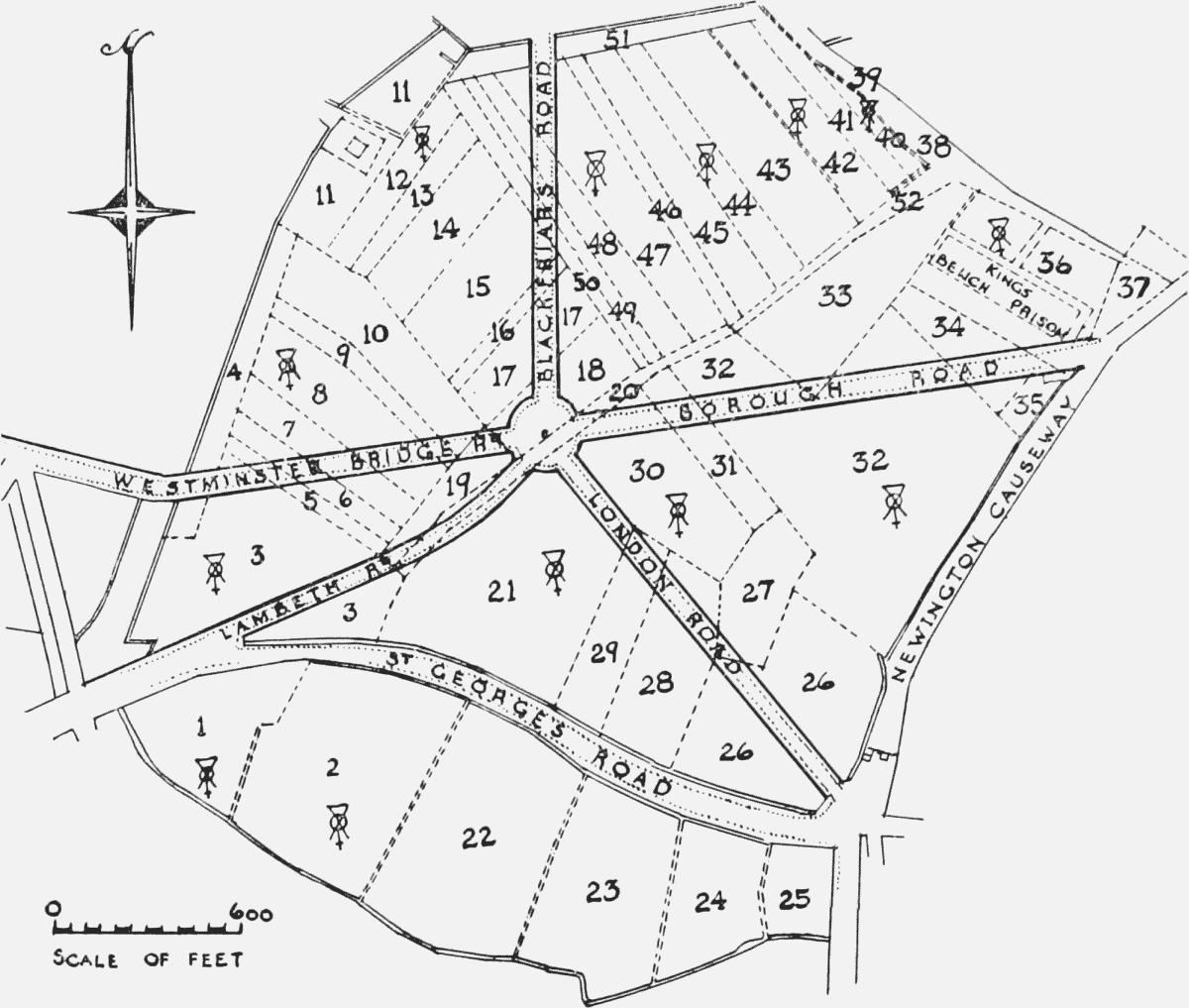
Plan of St. George's Fields circa 1760–70
Plots Nos. 1–3, 8, 12, 16, 18, 21, 30, 32, 35–38, 40, 42, 44, 47, 50–52 belonged to the Bridge
House. Owners of other plots are listed below and later buildings are given in brackets.
1 and 2. Moulton's Close (Bethlem Hospital).
3. (St. George's Cathedral).
4 and 7. Rev. Thomas Clarke.
9. Freehold of Paris Garden Manor.
10, 14, 31, 43, 45. Bower (1746), later
Quallett.
11. Part West family, part Baron family (5
Alls later the Halfway House).
13 and 28. Trustees of Marshall's Charity.
15. Rev. Thomas Clarke (Magdalen).
17. West family (Surrey Theatre).
19. Harp Acre.
20. Long Acre, Society of Friends.
21. (School for the Indigent Blind).
22. West family (West Square).
23. Hayle's Estate belonging to Lambeth
Parish.
24. West family.
25. (Fishmongers' Almshouses).
26. Sir John Lade, later Rolls' Estate.
27. (St. George's Market).
32. Formerly leased to St. Thomas' Hospital
(The Windmill, British and Foreign
Schools).
33 and 34. West family (King's Bench Prison).
35. The pound (Hay Market).
36. (Skin Market).
37. (Houses in Blackman Street).
38–40. St. John's Acre, copyhold of Paris
Garden Manor. Dirty Lane (Great
Suffolk Street). The City claimed all
three plots, c. 1800.
41. Hangman's Acre (House of Correction).
42. (Drapers' Almshouses, built 1820).
46. Lamp or Mill Acre (Miniver Street).
47. (Lancaster Street).
48 and 49. Society of Friends (Red Cow).
51. (Pocock Street).
The plan on p. 50, which has been compiled from several 17th and 18th century plans in the City Records Office, gives some indication of the division of St. George's Fields between different owners circa 1760–70. About half the acreage belonged to the Bridge House (approximately 70 acres out of a total of 144 in 1621) and the Bridge House Committee were therefore concerned to have their rights of ownership clearly recorded and to prevent encroachment. A survey or view made in 1601 records (fn. 150) that the Bridge House strips were marked by corner stones and by wooden stakes, the latter curiously named, sugar loaf, cock, pigeon, tubalkin, etc. These landmarks were liable to be moved by accident or design, and the Committee found it necessary to make new surveys from time to time. (fn. n2) The first precise map dates from about 1621, and the key to it gives the ownerships and acreage of the holdings in detail. (fn. n3) (fn. 125)
In December, 1735, a special sub-committee was appointed to survey the fields afresh. (fn. 9) They found that a number of the Bridge House boundary new stones had been moved, and after ordering that stakes should be driven in to replace them as a temporary measure, they suggested that a further survey should be taken in haytime when everyone would "be at Work upon his own Ground, and their several Claims be then the better distinguished." The new stones which were set up as a result of this survey bore the Bridge House Mark. The plan of the fields made at this time is still in the City Records Office, with the lines of the Blackfriars Bridge approach roads drawn across it at a later date. (fn. 152)
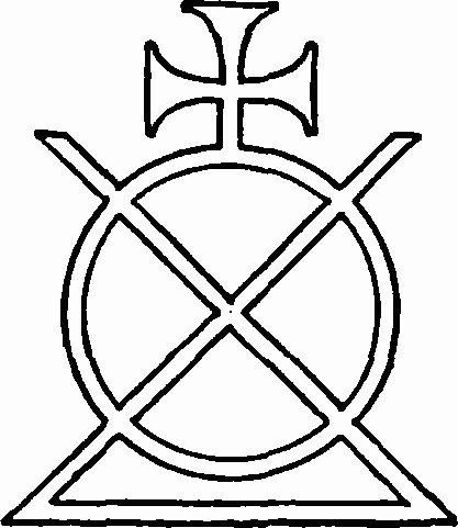
The Bridge House Mark
In March, 1698/99, the Bridge House Committee discussed with the other property owners of St. George's Fields the possibility of promoting a Bill in Parliament to enable them to enclose and consolidate their holdings, (fn. 16) but nothing came of this project, and the first serious agitation for the enclosure of the fields began in 1746 when Thomas Clarke, the main lessee of the Bridge House Estate there, complained to the Committee about the inconveniences which he and other occupiers suffered because their lands lay open—waggons were driven across the fields, to the ruin of the herbage, in order to avoid the turnpikes where weighing machines to assess tolls had recently been set up; also, during the recent "great murrain" of cattle, one infected beast driven on to the fields to graze had infected many others and caused a great many deaths. The report of the Surveyor to the Bridge House Committee endorsed Clarke's statements, but the Committee took no positive action, except to put up notices in the fields prohibiting the driving of waggons and carts there. (fn. 9) They gave their consent to Clarke and others presenting a petition to Parliament if they wished, but insisted that even if the land were enclosed, building should be forbidden there. As the Committee would give no active support to the project it was allowed to drop.
By 1773, the lease of the greater part of the Bridge House lands in St. George's Fields granted to Richard Hall in 1714, and subsequently held by Clarke, had come into the hands of James Rowles (Rolls). Six acres 33 perches had been taken out for making and widening the roads and the rest had been let out to various under-tenants "whereby many Encroachments trespasses and Innovations appear to have Arrisen," (fn. 9) and George Dance was ordered to make a new survey. Pending a decision as to a long-term tenancy, a three-year lease of the main part of the Bridge House holdings, including the "mineral spring" at the Dog and Duck, which was leased to Mrs. Elizabeth Hedger at about £50 a year, and the Hay Market near Blackman Street, which brought in about £24 a year, was granted to Rowles, while the remainder of Moulton's Close was granted to Edward Henshaw, linendraper, for the same term. At the end of this term Rowles was outbidden by Mrs. Hedger's son, James, who was promised a lease of all the Bridge House holdings for a rent of £500 a year and an undertaking to spend £500 in repairing the Dog and Duck.
Something must now be said about the Dog and Duck (Plate 37a),
since it played an important part in the later history of St. George's Fields.
It abutted on Lambeth Road near Kennington Road, and was encompassed
on three sides by ponds, in two of which the eye of fancy can discern the
shapes of a dog and duck (see Plate 53). It probably owes its name, however, to
the sport of hunting ducks with dogs. A small refreshment house seems first
to have been opened there in the time of the Commonwealth. (fn. n4) It was well
situated to attract chance trade, and after 1730, when the proprietor conceived
the idea of profiting by the current craze for drinking medicinal waters, it soon
became the 18th century equivalent of a 20th century road-house. In 1774,
John Burgoyne proclaimed in the prologue to The Maid of the Oaks that—
"St. George's Fields, with taste and fashion struck,
Display Acadia at the Dog and Duck." (fn. 18)
An advertisement which appeared in 1773 is typical of many (fn. 154) —
"St. George's Spaw, Dog and Duck, St. George's Fields. The Waters of this Spaw are now in their utmost perfection, and to be had at 6d. per gallon … These waters are recommended by the most eminent physicians, for the cure of the rheumatism, stone, gravel, fistulas, ulcers, cancers, sore eyes, and in all kinds of scorbutic cases whatever; and are remarkable for restoring a lost appetite . . . A cold bath from the above mineral. The long room fitted up for large entertainments. Tea, coffee and hot rolls as usual."
The Hedgers, mother and son, still further enlarged the premises and the inventory annexed to their lease in 1785 (fn. 155) describes the bar, the old and new tea rooms, the latter with a music gallery supported by "Ionick and Cabled columns," the Ladies' Bath and the Gentlemen's Bath, each covered with a leaded dome, the pleasure garden and bath with 21 drinking boxes, the skittle grounds, bowling green, etc. By this time, as various contemporary prints show, the place had become a resort for dissolute characters and sharpers, and in 1787 the Surrey magistrates refused to renew the licence. The Hedgers appealed to the City Corporation, who granted a new licence on the ground that they had judicial rights over Southwark. The legality of this was tried in 1791 when a decision was given in favour of the Surrey magistrates and the licence of the Dog and Duck was made conditional on its being closed on Sundays. The place was finally closed in 1799. James Hedger had, however, already amassed a sufficient profit to enable him to speculate extensively in building in the fields.
Although Hedger had been promised a lease of the Bridge House property in St. George's Fields in 1776, it was not until 1785 that a formal lease was signed. (fn. 155) Between 1780 and 1800 Hedger and his son James (fn. n5) also acquired an interest in a large part of the remainder of the fields on which they began to build houses. Before the Magdalen Hospital had been built near the Blackfriars Road in 1769 and the House of Correction in Hangman's Acre in 1772, authority had been obtained from Parliament to extinguish the rights of common on those plots. (fn. 157) Hedger bothered with no such preliminaries, but as he had covenanted not to build on City property, he applied in 1788 for permission to do so. His request was refused, for the Court of Common Council were already seeking legal advice as to the possibility of prosecuting him for building on commonable land. The oldest inhabitants were called in to give evidence, and they stated that of old custom the gates were thrown open after Lammastide and everyone who held property there was allowed to graze cattle freely—one horse or two cows for each acre held—and all the cattle turned in were marked by the pound keeper with the Bridge House Mark for a small fee—but counsel advised (fn. 16) that it would be difficult to make out a legal case for the enforcement of the custom against Hedger's wishes, since it was originally intended to be solely for the benefit of those who held land in the fields, and Hedger now had a controlling interest there. The matter was allowed to drop, but the City Corporation continued to take a close interest in developments in the fields. In 1788 George Dance, the City Surveyor, was asked to mark on a plan of the fields the buildings so far erected there (Plate 22) and further plans and surveys of the fields were made in 1790, 1792 and 1794. (fn. 9)
After 1785, other landholders of St. George's Fields began to follow Hedger's example in developing their land for profit. The most substantial houses, and the only ones of this period to survive, were those erected on the property of the West family in West Square, St. George's Road and Temple Place, Blackfriars Road (see below), and it seems reasonable to assume that the West family exercised some beneficial control over the buildings erected by their lessees. Hedger's building activities on the main part of the fields did not go unchallenged. In 1800 one of his tenants, named Harkness, refused to pay his rent and broke down some of Hedger's fences, on the ground that "the King of St. George's Fields", as he called Hedger, had no right to put them up. He was convicted and fined in the courts, but Hedger's costs were so high that he lost more than Harkness did over the case. (fn. 154)
The ground in St. George's Fields was mostly at or below high water level and it had always been soggy in wet weather. The main roads had been made up so that the water drained off them, but the house and surface drainage from the fields was still, for the most part, conveyed in the primitive ditches and open sewers which had sufficed when the fields were used only for agriculture. (fn. n6) Carts and coaches were still driven across the open ground when opportunity offered, to avoid the payment of toll, so churning up the mud; between the main roads there were only gravel footways. A writer in 1807 complained that it was impossible to walk there in the daytime without being above the ankles in wet and mud, while at night people were in danger of breaking their limbs by falling into ruts or over hillocks of rubbish. (fn. 154)
Long before the expiry of Hedger's lease in 1810, the City Corporation had decided that it would not be renewed and were making plans for the improvement of the district. The development of the fields had begun badly; not only was it haphazard and lacking in amenities, but the quality of the houses was generally so poor that only the lowest type of tenant could be persuaded to live in them. There was, however, one compensatory feature in the situation; when the City Corporation regained possession of the ground it could replan the area almost de novo, since there was every justification for pulling down the existing buildings. The first necessity was to secure a proper drainage system. In 1807 negotiations were begun with neighbouring landowners, the Archbishop of Canterbury who owned Lambeth Marsh, and the Prince of Wales who owned Prince's Meadows, and with the Surrey and Kent Sewer Commissioners, to promote a Bill in Parliament for this purpose, since the Commissioners had power only to maintain existing banks and sewers, not to make new ones. The proposal provoked some opposition from James Hedger, who thought his property might be adversely affected, (fn. 9) but the Bill was passed in 1809. (fn. 158) Seven years later, however, the Bridge House Committee were still debating the best method of draining St. George's Fields, and it was not until 1819 that general plans for doing so were agreed.
In 1807 the Bridge House Committee instructed George Dance to "prepare … Plans for letting and improving the several pieces . . . of Ground in Saint Georges fields now in Lease to Mr. James Hedger taking into Consideration the exchange or purchase of adjoining premises that may be necessary for such Improvement." (fn. 9) Two plans were produced by Dance, the earlier and more elaborate of which is reproduced on Plate 23. The layout of the main roads and of some of the connecting roads, which had become rights of way by usage, left a number of awkwardly shaped plots of ground; some of these Dance planned to fill with crescents, circuses and polygons, surrounded by houses and gardens.
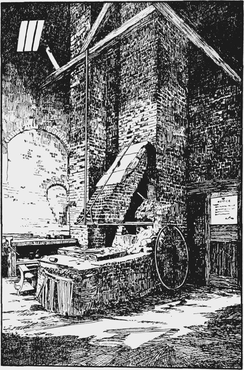
Smith's forge behind No. 159 Blackfriars Road
Eighteen years previously, Hedger had tried to establish a general provision market in St. George's Fields, to be known as St. George's Market. His attempt came to nothing owing to the opposition of St. Saviour's Vestry (fn. n7), but his market-place between London Road and Borough Road—a series of shops and stalls round a central paved square—provided a basis for the more elaborate plan suggested by Dance. In the latter scheme a circular courtyard replaced the square, and there were subsidiary openings surrounded with shops to fill the remainder of the triangular plot.
When Hedger and his tenants discovered that the City Corporation did not intend to renew his lease, they began to demolish the houses and other buildings in order to salvage the materials. The City officers tried to prevent this, but on the last day of the lease there was a riot in the fields, as several hundred people collected there to pull down the buildings. (fn. 154) Most of the houses that remained were retained temporarily by the occupants as tenants at will. The buildings were, however, in such bad condition that it was obvious that they could not last very long, and the City Corporation refused to be responsible for repairs.
In 1810 the City Corporation obtained an Act of Parliament extinguishing all rights of common over St. George's Fields and repealing a
clause in an Act of 1786 which prohibited building within 50 feet of certain
main roads there. The new Act specified that no houses "inferior to the
third building rate" should be erected on the frontages of Borough Road or
St. George's Road, or of the part of Westminster Bridge Road which traversed
St. George's Fields. (fn. 162) Two years later a further Act enabled the City Corporation to sell off or exchange certain small pieces of ground in the fields. (fn. 163)
During the following 20 years all the Bridge House lands there were let on
building lease, while the ground which did not belong to the Bridge House
was also closely built up. In 1813 James Smith wrote—
"Saint George's fields are fields no more;
The trowel supersedes the plough;
Swamps, huge and inundate of yore,
Are changed to civic villas now." (fn. 164)
For various reasons, very little of Dance's plans of 1807—09 materialized. The formation of Waterloo and Southwark Bridge Roads altered the configuration of the area north of Borough Road, while the grant of Moulton's Close to the Governors of Bethlem Hospital (see p. 77) and of ground in other parts of the fields to various charitable organizations (see Chapter 7) absorbed a considerable proportion of the rest of the Bridge House property. Probably, too, the City Corporation was not prepared to sanction the capital outlay which would have been necessary, for example, for the erection of St. George's Market as originally envisaged.
One of Dance's schemes was, however, carried out. The new buildings round St. George's Circus were built with a concave frontage at an even distance from the obelisk so that it became a circus in fact as well as in name. Some of the buildings erected in St. George's Fields during the first half of the 19th century still survive, though many of them were damaged during the 1939–45 war and most are sadly dilapidated. Brief accounts of the more important buildings or groups of buildings are given below.
Blackfriars Road (formerly Great Surrey Street)
The Magdalen Hospital, of which an account is given on p. 66, was built on the west side of Blackfriars Road before the road itself was completed. The hospital remained on the same site for a century and, after its removal to Streatham, the ground was bought by the Peabody Trust. Sixteen blocks of buildings, enclosing two quadrangles, were built there by William Cubitt & Co. from the designs of H. A. Darbishire (Plate 34). They were completed in 1872. A contemporary description (fn. 165) mentions that the Blackfriars Road buildings were plainer and less imposing in appearance than the earlier blocks erected by the Trust, (fn. n8) but were "more homelike and agreeable," with larger rooms and more cupboard space. (fn. n9) If architecturally they contrast unfavourably with the terrace houses of the preceding generation (see e.g. Plate 35) or with the working class cottages of the back courts built still earlier (Plate 33a and 33b) they certainly had more amenities than the latter. They mark the beginning of a new era in the provision of housing for the working class of this neighbourhood.
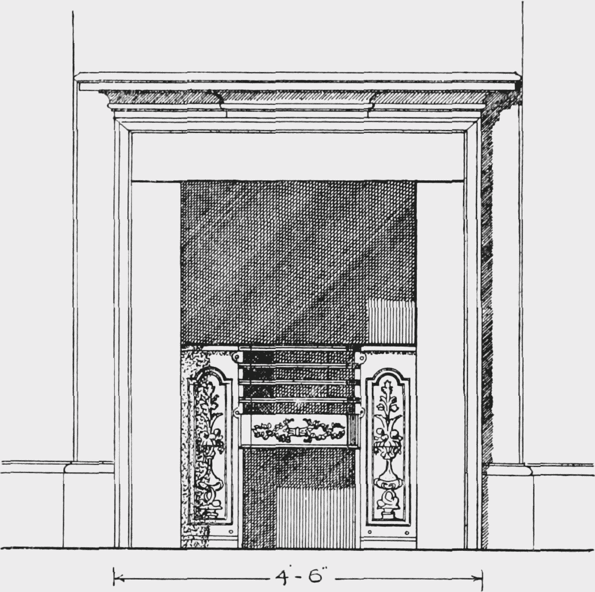
No. 139 Blackfriars Road, Fireplace on second floor
The Royal Circus and Equestrian Philharmonic Academy, the predecessor of the Surrey Theatre, was opened in 1782 on a piece of ground on the west side of Blackfriars Road near St. George's Circus, leased by Colonel Temple West to Charles Dibdin, the song writer, and Charles Hughes, a trick horse rider. (fn. 166) West himself gave some financial backing to the scheme, and proposed that stage entertainments should be given by children so that the theatre would form a school for young actors. It was burnt down in 1803 and was rebuilt from the designs of Rudolph Cabanel (who also designed the "Old Vic"), under the direction of James Donaldson junior (fn. 167) (Plates 30 and 32a). This building was also destroyed by fire in 1865 and was replaced by a third (fn. c1). Under the management of Robert Elliston, William Creswick, George Conquest, and others, the Surrey Theatre, as it was renamed in 1816, had many successes but declined in popularity after the death of Conquest in 1901. It became a cinema from 1920 to 1924 and then remained empty until it was pulled down in 1934 for the extension of the Royal Ophthalmic Hospital. (fn. 168)
The formation of Blackfriars Road cut across the strip of ground belonging to the West family in the centre of St. George's Fields (No. 17 on the plan on p. 50), leaving a triangular site on the east side of the road. This was let on building lease to Ezekial Delight (fn. 169) who erected a terrace of houses there, now Nos. 133–145, in 1793–94. Ezekial Delight was one of the four District Surveyors appointed by the City of London under the Building Act of 1794. He had disposed of the lease before his death in 1810. (fn. 170)
Thomas Dibdin, actor, dramatist and song writer, who ruined himself financially by his failure as proprietor of the Surrey Theatre, lived at No. 143 in 1817–20.
Benjamin Hanbury, nonconformist historian, whose uncle was minister of Union Street Congregational Church in 1803 to 1859, lived at No. 138 in 1810–54.
Augustus Applegarth (or Applegath), inventor of improvements in printing processes, and brother-in-law of Edward Cowper with whom he established a printing business in Duke Street, Stamford Street, lived at No. 137 in 1805–10.
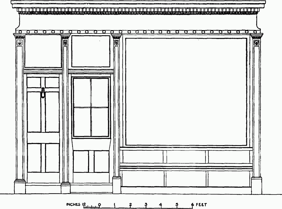
No. 159, of which only the ground floor is left, was built in 1818–19 by William Anderson of Neptune Place, Waterloo Bridge, stone mason, on land leased from the City Corporation. The shop front has Ionic columns and an enriched fascia.
On the south-east side of the yard behind No. 159 and about 250 feet from Blackfriars Road is a building dating from the early part of the 19th century. It now forms part of a British Road Services depdt. The building, which contains a forge, is of interesting construction, with wooden roof trusses in four bays carried on slender wooden columns.
Borough Road
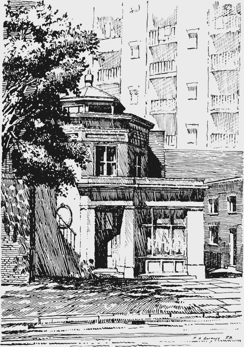
The houses on either side of the Borough Road, built on Bridge House Estate property during Hedger's tenancy, were demolished after 1810, but Nos. 2–4, 17–20, 61, 85, 86, 88–102, and 113–119, built between 1820 and 1830 under building leases from the City Corporation, still remain, though they are mostly in poor condition. They are all of three storeys, built in stock brick; most of them have shops on the ground floor. No. 85 has first-floor window guards with interesting winged ornament at the centres. They bear the Bridge House Mark. No. 62, the octagonal structure on the north side near Scovell Road, has sometimes been stated to have been the watch-house of the King's Bench Prison, but this was not so. It was built by Henry Robert Hartley, a stone mason, in 1821, on land leased to him by the City Corporation, and it has been in use, together with the adjoining yard, as a stone mason's or builder's premises ever since. It is now occupied by E. J. and A. T. Bradford, Ltd., architectural sculptors.
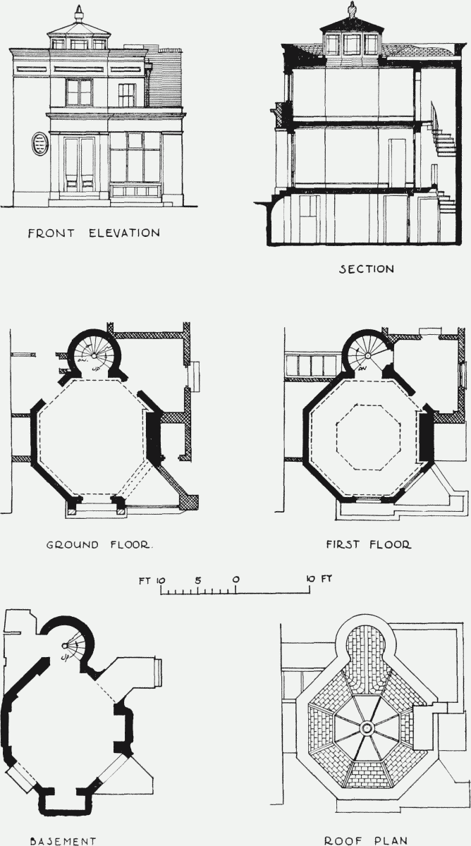
No. 62 Borough Road
St. George's Circus
The views of St. George's Circus on Plates 30 and 31 show that although ground was purchased in accordance with the Act of 1769 for the formation of a circus 250 feet in diameter, the line of the buildings subsequently erected there was by no means regular. Clauses in the Acts of Parliament relating to St. George's Fields of 1810 and 1812 stated that the circus was not to be reduced to less than 240 feet. The 1812 Act directed that all future buildings there should be "built up close to the said Circus, with concave Fronts in a uniform Manner … and not inferior to … the Third Rate of Building." (fn. 163) The slight encroachment made by the gateway to the School for the Indigent Blind erected in 1811–12 was condoned, but the other segments of the circus let on building lease between 1820 and 1830 all conformed to the new line. The Duke of Clarence public house, between London Road and Borough Road, built for John Ponton, victualler, in 1820; and the houses between Borough Road and Blackfriars Road, the Swan public house, and Nos. 11 and 8 St. George's Circus, built for David McLacklan of King Street, St. James's, baker, in 1824–28, and Nos. 10 and 9, built by George Sutton of Borough Road, builder, in 1828–30, still remain in good condition (Plate 28). Several of the houses between Blackfriars Road and Waterloo Road, built for Mary Johnson of the "Equestrian Coffeehouse" in 1821–25, were taken over by the Royal South London Ophthalmic Hospital after 1857. The present Royal Eye Hospital was built in 1890–91.
No. 62 Borough Road
St. George's Road and Lambeth Road
Nos. 63–83 St. George's Road, between Hayles Street and the entrance to West Square, on the south side of the old section of the road, were built and in occupation by 1789, a few years before the houses in West Square. This and the adjoining terraces were originally known as Prospect Place.
In 1838, when the grounds of Bethlem Hospital were enlarged, the lines of St. George's Road and Lambeth Road were altered. A triangle of vacant land was left between them which the City Corporation assigned to the Governors of the hospital. (fn. 171) The ground was let on building lease, and Nos. 105–145 St. George's Road (Plate 35), formerly named Laurie Terrace (after Sir Peter Laurie, president of Bethlem and Bridewell Hospitals in 1833–61), were built in 1842 by W. R. Glasier and Jeremiah Thomas Crawley. (fn. 171)
No. 9 St. George's Circus
Barkham Terrace, named after Edward Barkham, an 18th-century benefactor of Bethlem, (fn. 172) was built in the same year by Henry Heard of Castle Street and Ann Hewett of the New Kent Road. (fn. 171) The remaining houses, Nos. 56–72 Lambeth Road, form a three-storey terrace of Gothic character faced in stucco and relieved by shallow bay projections through the ground and first floors of each house. Each bay has a balcony at first-floor level. An uncommon feature of the terrace is the chamfering of all the window and door openings. There are small lodges of similar character at each end of the terrace, part of which was demolished for the erection in 1939 of the hospital of the Catholic Nursing Institute (designed by Robert Sharp). The centre of the terrace was occupied from 1864 until its demolition in 1952 by the Upton Baptist Chapel (Plate 42b), built from the designs of J. E. Goodchild. (fn. 173) The building now housing the Elizabeth Baxter hostel, in the angle between the two roads, dates from 1841. The hostel was founded in 1906 for the welfare of stranded girls. (fn. 174)
Nos. 15–31 King Edward Walk are all that remain of the long plain terrace of two-storey houses which originally formed the third side of the triangle of ground built up circa 1840. All the houses have semi-basements; Nos. 15–17, which were originally the central houses of the group, are set forward slightly and have raised parapets.
Nos. 34 and 30 West Square
Miniver Street
Miniver Street (fn. n10) (formerly St. Martin Street) was built up in the early years of the 19th century. No. 14, with its bowed shop-front (Plate 11b), dating from about 1817, and the last of the original houses, was demolished in 1950.
Southwark Bridge Road
One of the early terraces of houses in this road, Sussex Place, between Lancaster Street and Keyworth Street (Plate 29c), still survives in Nos. 190–220. The houses were built by a number of separate speculative builders, Peter Wadey, George Castleman, etc., in 1826–30, on land leased by the City Corporation.
West Square
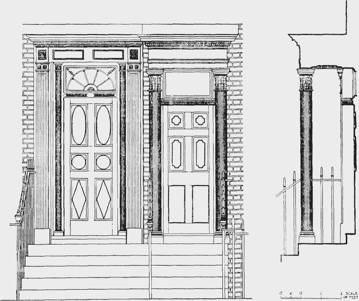
The largest of the several plots of ground in St. George's Fields, which belonged in the middle of the 18th century to Henry Bartelote and then to the West family (see the plan on p. 50), was the close lying south of St. George's Road, between Moulton's Close (the Imperial War Museum) and the ground belonging to Hayle's Estate. Colonel Temple West died in 1784, leaving his freehold estate in St. George's Fields to his wife Jane, during her life, and after her death, to his eldest son, Temple, in tail male. (fn. 176) They were empowered to make leases of up to 99 years, and in 1791 they granted building leases of the site of West Square to Thomas Kendall and James Hedger. (fn. 177) Most of the houses on the north, east and west sides of the square were completed and occupied by 1794, and the majority still remain (Plate 43); they are nearly all three-storeyed. Nos. 25–28 on the south side, built a few years later, are a storey higher. These have rectangular patterned door fanlights. The houses on the west side of the square are grouped formally; the two centre houses, which are surmounted by a pediment, and those adjoining them on either side, are set forward slightly as are the two houses at each end of the terrace. The open space in the centre of the square is now maintained by Southwark Borough Council.
Nos. 29 West Square and No. 1 Orient Street
In 1812, the Admiralty erected a tower on No. 36, on the east side of the square, for the shutter telegraph apparatus used to convey messages between Whitehall and New Cross, and thence to and from Chatham and Sheerness (Plate 44a). (fn. 178) Robert Barker (1739–1806), who painted panoramas and exhibited them in Leicester Square, erected a round wooden building for his work in West Square (Plate 44b). He lived at No. 14 from 1799 to 1806, and his widow continued to occupy the house after his death. His son, Henry, who assisted him in painting the panoramas, lived at No. 13 from 1802, when he married a daughter of William Bligh, commander of the Bounty, until 1824. No. 15 was occupied in 1804–09 by Henry Perkins (1778–1855), bookcollector and a partner in the firm of Barclay, Perkins, brewers.
James Hedger occupied a house in South (now Austral) Street. He had a garden on the west side extending along the back of West Square, and mews or stables on the opposite side of the street. (fn. 5) His son, James, lived in the square at No. 45 from 1808 until his death in 1812, when he was succeeded by his brother Robert. Another brother, William, occupied No. 31 from 1807 until 1819.