Survey of London: Volume 5, St Giles-in-The-Fields, Pt II. Originally published by London County Council, London, 1914.
This free content was digitised by double rekeying. All rights reserved.
'Site of Rose Field: Macklin St., Shelton St., Newton St. (part) and Parker St. (part)', in Survey of London: Volume 5, St Giles-in-The-Fields, Pt II, ed. W Edward Riley, Laurence Gomme (London, 1914), British History Online https://www.british-history.ac.uk/survey-london/vol5/pt2/pp27-32 [accessed 30 April 2025].
'Site of Rose Field: Macklin St., Shelton St., Newton St. (part) and Parker St. (part)', in Survey of London: Volume 5, St Giles-in-The-Fields, Pt II. Edited by W Edward Riley, Laurence Gomme (London, 1914), British History Online, accessed April 30, 2025, https://www.british-history.ac.uk/survey-london/vol5/pt2/pp27-32.
"Site of Rose Field: Macklin St., Shelton St., Newton St. (part) and Parker St. (part)". Survey of London: Volume 5, St Giles-in-The-Fields, Pt II. Ed. W Edward Riley, Laurence Gomme (London, 1914), British History Online. Web. 30 April 2025. https://www.british-history.ac.uk/survey-london/vol5/pt2/pp27-32.
In this section
XXX.—SITE OF ROSE FIELD (MACKLIN STREET, SHELTON STREET, NEWTON STREET (PART), AND PARKER STREET (PART).
Macklin Street (formerly Lewknor's Lane), Shelton Street (formerly St. Thomas's Street, afterwards King Street), the lower end of Newton Street (formerly much narrower and known as Cross Street) and the greater portion of Parker Street, have all been formed on the site of Rose Field, a pasture of a reputed area of six acres, attached to The Rose inn.
From particulars given in various deeds it is clear that the field's western and eastern boundaries respectively were Drury Lane and the stream (fn. 1) dividing it from Purse Field, and that its southern boundary ran 50 feet to the south of Parker Street. As regards its northern boundary, however, there is some uncertainty. The facts, so far as they have been ascertained, are as follows.
The houses on the north side of Macklin Street were entirely in Rose Field, as also were three houses in Drury Lane, north of Macklin Street, (fn. 2) and the line bounding the rear of the Macklin Street property certainly coincides, at least for a portion of its length, with the boundary of that part of Rose Field leased to Thomas Burton. (fn. 3) It may therefore be regarded as certain that at least for a portion of its length this line represents the northern boundary of Rose Field. Probably this is true as regards its whole length as far as Goldsmith Street, which seems to be the point at which it turned northwards. (fn. 4)
The first reference to Rose Field (though not under that name) which has been found, occurs in the deed concerning the exchange which Henry VIII., in 1537, effected with the Hospital of Burton Lazars. According to this, part of the property transferred to the Crown consisted of "one messuage, called The Rose, and one pasture to the same messuage belonging."
In the following year the king leased the inn and pasture to George Sutton and Ralph Martin. (fn. 5) In 1566 the property was leased to John Walgrave for 21 years as from Michaelmas, 1574; in 1580 to George Buck for 21 years, as from Michaelmas, 1595; and on 27th October, 1597, was, together with other property, granted by Elizabeth in perpetuity to Robert Bowes and Robert Milner, at a rent of £3 6s. 8d. Two days afterwards Milner sold it to James White, of London, silk weaver, and on 19th January, 1599–1600, the latter in turn parted with it to William Short. (fn. 6) Half a century later, William Short the younger took advantage of the sale of the Fee Farm Rents during the Commonwealth to redeem his rent for £29 12s. 6d. (fn. 7)
Before continuing the history of Rose Field, it may not be out of place to consider where The Rose inn, from which the field derived its name, was situated.
Parton (fn. 8) quotes a deed, dated 1667, referring to the sale by Edward Tooke to Luke Miller, of two tenements, situated in Lewknor's Lane, "which said two tenements doe abutt on the tenement formerly known by the sign of The Rose, late in the tenure of Walter Gibbons," and draws the inference that the inn was "on the south side of Holborn, not far eastward from The White Hart." It is, however, doubtful if "the tenement formerly known by the sign of The Rose" was The Rose of Rose Field; for when, ten years previously, William Short had sold to Edward Tooke the first 21 houses on the north side of Lewknor's Lane, which must have included the two tenements subsequently sold by Tooke to Miller, Walter Gibbons was in occupation of the twelfth house. It is therefore most probable that The Rose in question was a house in Lewknor's Lane, and not The Rose of Rose Field at all.
As a matter of fact, the latter is almost certainly to be identified with the inn of that name situated on the north side of Broad Street. In 1670 this inn was in possession of Sarah Hooper, widow of William Hooper, and the latter's son Benjamin, and is described in a deed (fn. 9) dated 2nd November in that year, as "all that messuage or tenement and brewhouse, with appurtenances, called The Rose, and all stables, maulting roomes, yardes, backsides, etc." On 26th March, 1723–4, Benjamin Hooper granted (fn. 10) "all that messuage or tenement and brewhouse, with the appurtenances, called The Rose Brewhouse, scituate in St. Giles in the Fields, now or late in the tenure of Samuel Hellier, Anthony Elmes, and Charles Hall, some or one of them, and all stables, malting houses, yards, backsides, ways, passages, etc.," to his two daughters, Jane Edmonds and Sarah Mee. The sewer ratebook for 1718 shows "Mr. Anthony Elmes" at a house in Broad Street close to Bow Street (now Museum Street) corner, (fn. 11) and thus the site of The Rose can be roughly identified. (fn. 12)
The necessary connection between the Hoopers and William Short, who owned The Rose of Rose Field, seems to be supplied by an entry in the Feet of Fines, dated 1640, concerning a purchase from the latter by William Hooper of a messuage and one stable with appurtenances in St. Giles in the Fields. (fn. 13)
To return now to the history of Rose Field. William Short does not appear to have taken any steps to develop the property for 15 years. On 28th July, 1615, however, he leased to Walter Burton the southern portion of the field. (fn. 14) From particulars obtained from a number of deeds it is known that the ground in question extended 50 feet on either side of Parker Street, i.e., from the southern boundary of the field as far north as the site of the garden afterwards in the occupation of John Fotherly. (fn. 15) Whether the lease actually included the site of the garden, it is not possible to say with certainty.
On 5th December, 1615, Short leased to Thomas Burton the portion to the north of the garden, "the said parcell … being mencioned in the said indenture to abutt east on the lands of Sir Charles Cornwallis, Knt. [i.e., Purse Field], west upon Drury Lane aforesaid, north upon the common sewer (fn. 16) which then divided the same from other lands of the said William Short then also in the occupation of the said Thomas Burton, (fn. 17) and south upon the lands of the said William Short lately demised to the said Walter Burton; and therein mencioned to conteyne in breadth from north to south on the west end that did abutt on Drury Lane 233 feete, and at the east end thereof in breadth from north to south 80 feete, and in length from east to west, viz., from the Cornwallis lands on the east to Drury Lane on the west 719 feete." (fn. 18)
The earliest mention of Lewknor's Lane which has been discovered is in an entry in the Privy Council Register (fn. 19) for 27th January, 1633–4, dealing with the case of Richard Harris, the owner of four houses "in Lewkner's Lane, backside of Drury Lane." Harris explained that he obtained the houses by purchase, and that they had been built six years. This takes the date of at least some of the houses in the street back to 1627 or 1628, and the fact that the street is not mentioned in the Subsidy Roll for the latter year makes it probable that these four houses were among the first built.
The usual reason given for the name of the street (afterwards corrupted to Lutenor, Newtenor) is that it was formed on the site of the house and grounds of Sir Lewis Lewknor. It is known that Lewknor was living in Drury Lane in 1620 and 1623 (fn. 20) and the position of his name in the Subsidy Roll for the latter year points to his house having been in about the position suggested. (fn. 21) There is no evidence, however, that the house was built before 1615, when the land was leased to Burton, and it does not seem likely, therefore, that it would be pulled down by 1628.
The name of the street was subsequently changed to Charles Street, and again altered to Macklin Street in 1878. (fn. c1)
Shelton Street does not date back so far as the remaining streets formed on Rose Field. As late as 1665, (fn. 22) when Lewknor's Lane and Parker's Lane had long been laid out, the houses on the north side of the latter were described as reaching to the garden "now or late" in the occupation of John Fotherly. In a deed of 1650 (fn. 23) the garden is said to be "now in the occupation of the Lady Vere," and a short time before it had been in the tenure of Sir John Cotton. (fn. 24) The street was formed before 1682, it being shown in Morden and Lea's Map of that date, and was at first known as St. Thomas's Street. In 1765 the name was changed to King Street, probably out of compliment to Joseph King, who took a lease of a large portion of the property in the street about that date. (fn. 25) Formerly in the flank wall of No. 166, Drury Lane, was a stone tablet bearing the inscription "King Street. 1765." In 1877 the street received the name of Shelton Street, and, with the carrying out of the Shelton Street housing scheme by the London County Council was almost entirely swept out of existence between 1889 and 1892.
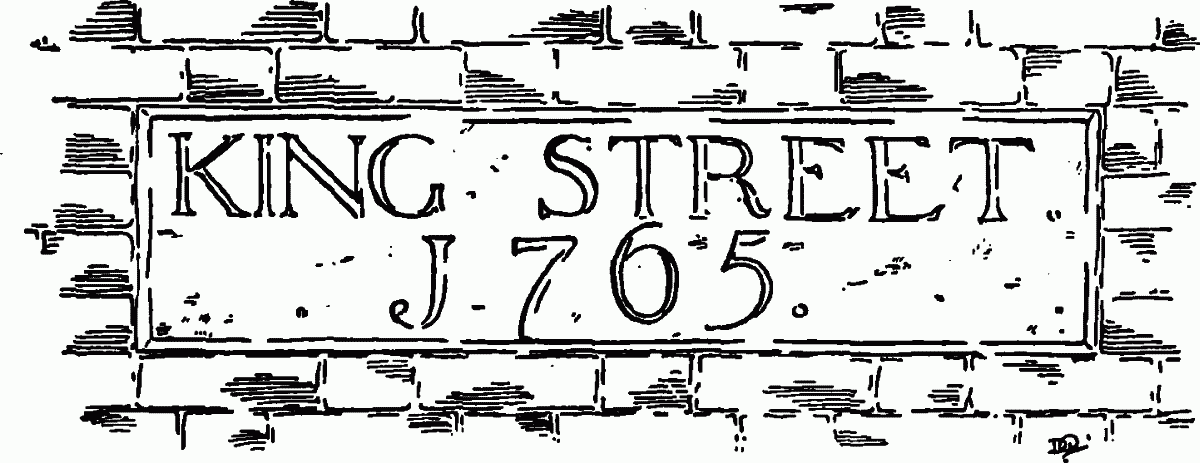
Stone Tablet (1765), formerly on flank wall of No. 166, Drury Lane
The earliest reference to Parker Street (formerly Parker's Lane) so far discovered, belongs to February, (fn. 26) 1620, when mention was made of "a way or passage of twenty feet broad, lately marked out by the said Walter Burton, leading from Drury Lane to and through the ground of the said Sir Charles Cornwallis, knight, towards Holborn." (fn. 27) The "marking out" of Parker Street took place therefore between July, 1615, and February, 1620. There seems great probability that the street owed its name, as suggested by Parton, (fn. 28) to Philip Parker, who certainly had a share in building the houses there (fn. 29) That he actually held ground in the neighbourhood of Parker Street is evident from the terms of Burton's lease to Edlyn of 1620, when, in granting his own interest in the land on the south side of Parker Street for a space of 520 feet westwards from the Rose Field boundary, he adds: "and the said Thomas Burton grants to Edmund Edlyn all the interest, right, claim or demand which he hath or ought to have in and to that piece of ground holden by Philip Parker." In the Subsidy Rolls for 1620–21 and 1618–9, Philip Parker is shown as residing in Drury Lane, perhaps the house (the third on the east side, north of Parker Street) where William Parker was living in 1646. (fn. 30)
The Council's collection contains:—
(fn. 31) No. 166, Drury Lane. Stone tablet (drawing).