Survey of London: Volumes 31 and 32, St James Westminster, Part 2. Originally published by London County Council, London, 1963.
This free content was digitised by double rekeying. All rights reserved.
'Broadwick and Peter Street Area', in Survey of London: Volumes 31 and 32, St James Westminster, Part 2, ed. F H W Sheppard (London, 1963), British History Online https://www.british-history.ac.uk/survey-london/vols31-2/pt2/pp219-229 [accessed 30 April 2025].
'Broadwick and Peter Street Area', in Survey of London: Volumes 31 and 32, St James Westminster, Part 2. Edited by F H W Sheppard (London, 1963), British History Online, accessed April 30, 2025, https://www.british-history.ac.uk/survey-london/vols31-2/pt2/pp219-229.
"Broadwick and Peter Street Area". Survey of London: Volumes 31 and 32, St James Westminster, Part 2. Ed. F H W Sheppard (London, 1963), British History Online. Web. 30 April 2025. https://www.british-history.ac.uk/survey-london/vols31-2/pt2/pp219-229.
In this section
Broadwick and Peter Street Area: Colman Hedge Close
Colman Hedge Close (figs. 2, 38) was a field of six acres on the west side of Colman Hedge Lane, now Wardour Street, and was the only part of the area covered by this volume which was not acquired by Henry VIII for the formation of the Bailiwick of St. James. (fn. 1) Some building took place here as early as the 1620's, but the development of the close was not completed until the early eighteenth century.
In 1455 Colman Hedge Close was in the possession of William Say, described as 'de Hospitio D[omini] Regis'. (fn. 3) This was probably the William Say who was master of the Hospital of St. Antony in Threadneedle Street and Dean of the King's Chapel, and who may perhaps be identified with William Say, Dean of St. Paul's. (fn. 4)
In April 1455 William Say conveyed the freehold of Colman Hedge Close, then described as six acres of arable land, to William Nicholl of London, brewer, and John Davey for an unspecified sum. During the next hundred years the field passed through the hands of various other owners and in October 1572 John Denham, of London, goldsmith, bought it for £60. Denham's name appears as owner on the plan of 1585 (see Plate 1), but in the previous September 1584 he had in fact sold the close to John Gisbie of Heston, brickmaker, for £101. The latter was perhaps responsible for digging the gravel pits which remained a feature of Colman Hedge Close until the late seventeenth century. (fn. 5)
The close continued in the possession of the Gisbie family until January 1630/1 when Edward Gisbie (Gisby), probably a son of John, sold Colman Hedge Close to Sir Edward Wardour, a prominent official of the Exchequer, for £825. (fn. 6)
At the time of the sale there were about a dozen houses in the close, several of which had evidently been erected since 1623. (fn. 7) In April 1630 the churchwardens of St. Martin's acquired for £40 the lease of one of these houses, near the western boundary of the close, for use as a pesthouse, plague then being prevalent in London; the annual rent of £8 16s. for the premises was at first paid to Edward Gisbie, and after the sale of January 1630/1 to Sir Edward Wardour. (fn. 8) In 1632, when the outbreak of plague had declined, the vestry tried to let the house to a private tenant upon the condition that they could 'have the same in time of need upon a days warning'. In the following year the conversion of the pesthouse into 'a fit workhouse for the begging poor of this parish' was considered, and in 1638 the vestry decided to dispose of their lease. (fn. 9) The building is marked as a pesthouse on a map of 1664. (fn. 10)
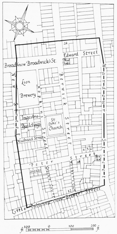
Colman Hedge Close, layout plan. Based on the Ordnance Survey, 1870–5
Another of the houses standing on Colman Hedge Close was converted into a brewhouse sometime before 1647, and let by Nathan Butler, an under-tenant of Sir Edward Wardour, to one Roberts. (fn. 11) In 1656 there was also a saltpetre house in Colman Hedge Close, probably erected by William Gegg of Soho, carpenter, to whom a twenty-one-year lease of the building was granted by Mary Wardour. (fn. 12) It was probably situated between what are now Brewer Street and Peter Street, and may have given its name to the latter. It may also have been responsible for the name Powder or Gunpowder Street which was applied to the western portion of Brewer Street in the late seventeenth century (see pages 118, 228).
These early buildings must have covered a considerable portion of Colman Hedge Close, and were probably situated along the western side of Colman Hedge Lane (now Wardour Street) and on the northern side of the narrow passage (now Brewer Street) to Sir William Pulteney's property. There was evidently no other formal street layout in the close until the 1670's, when Peter Street developed, probably out of a passage to the salt-petre house. (fn. 13)
By this period the freehold of Colman Hedge Close had descended to Edward Wardour, who had probably inherited the property on the death of his grandfather, Sir Edward Wardour, in 1646/7. (fn. 14) In 1685 a group of speculators came to an agreement with Wardour to take a lease of the property 'for the premises to be improved by Building'. The prospective lessees were James Pollett, a cook turned building speculator, Joseph Collens, carpenter, and Robert Walkton. (fn. 15) Pollett had already acquired long leases of Little Gelding's Close and Doghouse Close, both of which abutted on the northern part of Colman Hedge Close (see pages 243, 230 and fig. 2).
In November 1685 the three partners agreed amongst themselves as to their respective shares in the field to be leased from Edward Wardour. Pollett was to have a half share and Collens and Walkton a quarter share each. They must have already laid out parts of the property for building (although their lease was not signed until the following month) and must also have come to agreement with a number of building tradesmen prepared to take up sub-leases of individual sites. The lease of December 1685 was made to James Pollett, acting for himself and as trustee for his two partners. It was for ninety-one years at a rent of £200 per annum and included a covenant by Pollett to spend £1400 on the development of the property. (fn. 16)
In the years immediately following, Pollett and his associates were successful in sub-leasing most of the building sites in Colman Hedge Close, those which fronted on to Wardour Street, the modern Brewer Street and Edward Street (now part of Broadwick Street) being built up between 1686 and 1692.
In the western part of the close Pollett appears to have intended to lay out a large market square. In 1687 he and Charles Clutterbook obtained from James II a grant of the rights in the haymarket then held in the street of that name, (fn. 17) and in the following year, after acquiring Clutterbook's interest, Pollett was granted the right to transfer that market to his own ground in 'the olde Sohoe'. A condition of this second grant was that he should within two years make the new site 'fitt to receive the … Carts Wagons or Waines of hay and straw and for the keeping of the said market'. (fn. 18)
After the accession of William III Pollett was accused of being a professed papist and in 1690 both the grants from James II were cancelled. (fn. 19) By this time the layout of the market place had evidently begun, and the part of Broad Street in Colman Hedge Close was for some years known as 'the new Haymarket'. (fn. 20) In 1708 Berwick Street, whose eastern side to the south of Edward Street was probably intended to form the eastern side of the market square, was described as 'a kind of Row, the Fronts of the Houses resting on Columns, [which] make a small Piazza'. (fn. 21) In his comments on Berwick Street written in 1720 Strype stated that 'About the Middle of this Street is a Place designed for a Hay Market, and a great Part of the low Ground raised, with some of the Houses built Piazzo wise, and sustained by Stone Pillars; but whether it will be finished, Time will make appear'. (fn. 22) The failure of this scheme was probably the cause of the delay in the completion of the development of the western part of Colman Hedge Close, and for the haphazard layout between Peter and Broad Streets.
In 1714 the freehold of Colman Hedge Close was purchased by Pollett's executors for five thousand pounds. (fn. 23)
Wardour Street
Wardour Street derives its name from Edward Wardour, who owned the freehold of Colman Hedge Close. The street developed out of an ancient highway known as Colman Hedge Lane which extended from the Mews (formerly on the site of the National Gallery) to Tyburn Road (now Oxford Street). The southern end of this lane is now known as Whitcomb Street. The stretch between Coventry Street and Old Compton Street has formed part of Wardour Street since 1878, but was previously known as Princes Street and is so marked on the 1746 edition of Rocque's map.
The upper part of Colman Hedge Lane was known as Soho or Soho Street from the fields which bordered its eastern side. The name Wardour Street first appears in the ratebooks in 1689 and applied only to this part of the lane. Nevertheless 'Soho' as a name for this part of Colman Hedge Lane persisted and in July 1691 there is a reference to 'Old Soho, otherwise Wardour Street' in the Middlesex Sessions records, when the street was ordered to be paved. (fn. 24) This older name remained in use until at least 1746, when that part of the modern Wardour Street between Peter Street and Winnett Street is marked as 'Old Soho' on Rocque's map. In 1878 the name Wardour Street was extended to include Princes Street and the whole length of Colman Hedge Lane from Coventry Street to Oxford Street became known by its present name.
Only the western side of Wardour Street is described in the present volume, all the land to the east being in the adjoining parish of St. Anne, Soho. The west side of the street was bordered by four separate fields (see fig. 2)—Doghouse Close (Chapter XV), Colman Hedge Close (described here), Laystall Piece or Knaves' Acre (Chapter IX) and Vesey's Garden and Watts's Close (Chapter VIII).
Ogilby and Morgan's map (Plate 3a) shows that most of the part of the street described in this chapter had been developed by 1681–2. Building tradesmen to whom sub-leases were granted of land in Colman Hedge Close fronting the street between 1685 and 1689 include Nicholas Stone and John Marriott, bricklayers, Richard Tyler, brickmaker and William Oram, plasterer. (fn. 25) Many of the buildings now standing in this section of the street were erected in the 1920's and 30's for the film corporations with which Wardour Street is now associated; none of them is of interest.
Few large houses were built in Wardour Street and the street never seems to have had any pretensions to fashion, the inhabitants being chiefly tradesmen and innkeepers. In the early nineteenth century it was famous for its bookshops, much frequented by Charles Lamb. Later it 'became a by-word and a proverb, as the headquarters of curiosity-shops, antique and modern, genuine and fictitious'. (fn. 26) In the present century Wardour Street has become a centre for the music-publishing business, and more especially, the film-making industry.
The Intrepid Fox Public House
This public house owes its name to the enthusiastic partisanship of its proprietor, Samuel House, for Charles James Fox during the Westminster election of 1784. (fn. 27)
Broadwick Street
The street now known as Broadwick Street extends across four separate estates (see fig. 2)— Colman Hedge Close, Little Gelding's Close (both in the possession of James Pollett), Pawlett's Garden (Sir William Pulteney) and Pesthouse Close (the Earl of Craven). Building started at the eastern end in 1686, immediately after Edward Wardour's lease of Colman Hedge Close to Pollett, and proceeded intermittently westward, the final extension to Marshall Street being completed in 1736. Until 1936 the greater part of the street was called Broad Street, and the narrow eastern section Edward Street; in that year both these names were abolished and the whole thoroughfare is now called Broadwick Street.
Edward Street probably took its name from Edward Wardour, who had lived in a house on or near the site of the new street. Building began in 1686; an inscribed stone formerly at the corner of Wardour Street bore that date. (fn. 28) The street first appears in the ratebooks by name in 1689, when both sides seem to have been completed. Anthony Stephenson, carpenter, and John Marriott, bricklayer, were two of the tradesmen to whom Pollett and his associates Collens and Walkton granted building leases. (fn. 29)
After the failure of his scheme for a market (see page 220) Pollett appears to have decided to lay out a wide street in continuation of Edward Street across his ground in both Colman Hedge Close and Little Gelding's Close. Four houses on the south side of Broad Street between Berwick Street and New Street (now Ingestre Place) were built and occupied by 1693, and another five by 1695. (fn. 20) No further houses were built in Broad Street until after Pollett's death in 1703, (fn. 30) when his executors undertook the development of the vacant land and disposed of all the building sites on both sides of the street. Building must have begun almost immediately, for by 1704 there were already fourteen new houses built and occupied and by 1706 all the houses on both sides of the street in Colman Hedge Close and Little Gelding's Close were complete. (fn. 20) Nos. 42–46 (even) Broadwick Street, which still survive, belong to this stage of the development of the street and are described on page 248.
A house which formerly stood on the north side of this part of the street is illustrated by the drawing reproduced on Plate 122a; the drawing was evidently made during the occupancy of the Hon. Colonel Thomas Savill, who lived in Broad Street from at least 1716 until 1730. (fn. 20) The three-storeyed front was three windows wide with detailing very similar to that of the original houses in Golden Square. The windows were flatheaded with barred sashes in flush frames, the second and third storeys being finished with a bandcourse, while at the top was a modillioned eaves-cornice. The area-railing was divided at intervals by panels of wrought iron and the doorway had a moulded architrave surmounted by a swan-neck pediment on carved consoles. In the high-pitched roof was a single large dormer window with a triangular pediment.
Between 1718 and 1723 Broad Street was extended westward across William Pulteney's land in Pawlett's Garden, the width of the street being somewhat reduced. Nos. 48–58 (even) Broadwick Street, which were built here at this time, still survive and are described on page 214. The final extension of Broad Street into Lord Craven's Pesthouse Close to link up with Marshall Street did not take place until 1734–6. Of this development Nos. 60–74 (even) and 51–67 (odd) still survive and are described on page 203.
As a street of fairly large houses, Broad Street in its early days had a number of well-to-do residents, though none of any particular note. With the erection of the new houses on the Burlington estate and in St. George's parish, Broad Street (like Golden Square) quickly declined in fashion, and by the mid eighteenth century most of the houses were probably occupied by tradesmen and lodging-house keepers. (fn. 2) In the nineteenth century there was a further decline. A large brewery occupied a range of buildings on the south side of the street and many of the houses were sub-divided as workrooms or tenements. The original houses seem to have been little altered and the visual aspect of the street did not greatly change until the erection of the large blocks on the south side of the street in the 1930's.
Broadwick Street is irregular in character, reflecting its piecemeal development. The part east of Berwick Street is little more than an entry from Wardour Street, lined mostly with late nineteenthand twentieth-century warehouse and tenement buildings. The earliest building is the Bricklayers' Arms, on the east corner of Duck Lane, which probably dates from the mid nineteenth century. The part between Berwick Street and Lexington Street is much wider, and has been almost entirely rebuilt with large modern blocks. The south side is made up of three blocks, all faced with red brick and stone, Broadwick House, Trenchard House and Colquhoun House. Trenchard House is the best of them; it was erected as a police section house in 1938–40 to the design of Stanley G. Livock. The blocks on the north side are completely undistinguished, the only surviving buildings of interest being Nos. 42–46 (even), which are early eighteenth century. The western end of the street contains the greatest interest, since most of the original houses have survived, Nos. 39–49 (odd) alone having been rebuilt. Nos. 48–58 (even) comprise an exceptionally good and well preserved terrace but Nos. 51–67 (odd) and 60–74 (even) are in a bad state of decay.
In 1854 there was a severe outbreak of cholera in Broad Street and in the neighbouring streets. A total of seven hundred people died and in the forty-nine houses in Broad Street the inhabitants of only twelve escaped without a death. The Builder blamed the many cesspools in the street and called for a parish enquiry. (fn. 31) This was carried out in the following year by a vestry committee, which after deploring the presence of the numerous cesspools, the bad smells from the grease-boiling houses, the local cow-sheds and slaughter-houses, asserted that the outbreak had been caused by contaminated water from the pump before No. 40 Broad Street (now No. 41 Broadwick Street). The committee, largely influenced by Dr. John Snow, whose name has ever since been linked with the whole affair, then chained up the pump handle in a belated attempt to stem the epidemic. (fn. 32)
Snow, who then lived at No. 18 Sackville Street, had been investigating the causes of the spread of cholera for several years. He believed that the disease was water-borne and carried out a detailed investigation of the Broad Street outbreak. He found that in most cases the cholerastricken sick had drunk water from the street pump and that in premises with other water supplies the death rate was much lower. (fn. 33) Although his theory was confirmed by the cessation of the 1854 cholera epidemic, and generally accepted, the pump handle was later unchained and the well-water continued to be used for at least another decade. (fn. 34)
Dr. Snow's association with the street is now commemorated by the John Snow public house at No. 39 Broadwick Street, which stands near the site of the notorious pump.
Edward Street Baptist Chapel
Demolished
In or shortly after 1782 Richard Burnham established a Baptist chapel in Edward Street under the name of Elim or Salem. The chapel was described as 'a large room … converted into a place of worship', and Horwood's map of 1819 shows that it was on the north side of the street opposite Duck Lane. In 1795 Burnham and his followers moved to Grafton Street, and until 1805 the chapel in Edward Street was occupied by 'various adventurers.' (fn. 35) The chapel continued in use for some years, and is marked on a map of 1836 as a 'French Protestant Chapel'. (fn. 36)
The Lion Brewery
Demolished
There was a brewery on the south side of Broadwick Street from 1801 to 1937. In the former year two small houses, then Nos. 49 and 50 Broad Street, together with adjoining premises in New Street (now part of Ingestre Place) were taken by Messrs. Stretton, a firm of brewers. By 1824 the firm occupied all the premises in Broad Street between New Street and Hopkins Street. Two years later the brewery was taken over by Messrs. Goding and Broadwood and probably altered for them at about this time by the architect Francis Edwards. Later alterations were made to the brewery in 1885 by the builders Thornewill and Warham. The building was demolished in 1937 to make way for the present block, Trenchard House. (fn. 37)
Berwick Street
This street was probably named after the Duke of Berwick, an illegitimate son of James II. The latter may possibly have been a protector of the papist James Pollett, upon whose land the street was first laid out.
Berwick Street extends throughout almost the full length of Colman Hedge Close and Doghouse Close, both of which were held on lease by Pollett. The southern section, between Peter and Broad Streets, was laid out between 1687 and 1703, and the northern section, between Broad Street and Tyburn Road (now Oxford Street) a few years later. In 1687 Pollett built sewers in Berwick Street in the vicinity of Peter Street (fn. 38) and the street first appears by name in the ratebooks in 1689. Ten houses had then been built and occupied under sub-leases granted by Pollett's associate Joseph Collens, who seems to have been chiefly responsible for disposing of the sites in Berwick Street. Building tradesmen included Richard Avery, bricklayer, William Harper, glazier, William Oram, plasterer, Thomas Husbands, painter, and Thomas Parr and John Wrist, paviours. The evidence for the development of the southern part of the street is confusing, but probably most of the vacant sites were let and houses built there before 1703. (fn. 39)
Shortly after 1707 Berwick Street was extended north of Broad Street into Doghouse Close to link up with Tyburn Road. This new development was evidently carried out by Pollett's executors, who after his death in 1703 had been responsible for the completion of Poland Street and the eastern part of Broad Street. The buildings in this part of the street are described on pages 232–4.
In 1720 Strype described Berwick Street as 'a pretty handsome strait Street, with new well built Houses, much inhabited by the French, where they have a Church'. (fn. 24) Walford described the street in the nineteenth century as 'a haunt of artists of little note, and of trades subservient to an artist's requirements'. (fn. 40) In the 1850's and 60's the houses in this street and neighbourhood were denounced by The Builder as rookeries. They were all overcrowded and insanitary; the death rate was high and in 1854 there were many cases of cholera in Berwick Street. (fn. 41)
Berwick Street has retained its domestic character more than most of the streets in this neighbourhood, presumably because the presence of the market has discouraged large-scale rebuilding. Here and there a house has been replaced by a late nineteenth- or early twentieth-century building for use as a warehouse or workrooms, but these generally respect the original scale of the street. Two major exceptions are the large newly built blocks of flats, offices and shops on the west side, one by Westminster City Council, extending from Peter Street to Kemp's Court, and the other, known as Waverley House, replacing the former Nos. 62–66. The older houses are of three or four storeys with brick fronts two or three windows wide, the three-storeyed ones having a garret contained in a mansard roof. Although in most cases the fronts date from the late eighteenth or the nineteenth centuries, the rest of the house often dates from the early eighteenth century.
In the section of Berwick Street within Colman Hedge Close the whole of the west side has been rebuilt within the last ten or fifteen years, and although the east side retains many of its original narrow-fronted plots, not a single early eighteenth-century front remains. Several of the buildings on this side of the street appear to have been entirely rebuilt as tenements or warehouses in the mid to late nineteenth century and most of the others have fronts dating from the early nineteenth century. It has not been possible to examine any of the interiors.
Berwick Street Market
This market developed from the practice of shop-keepers displaying their wares on the pavement before their shops. There seems never to have been any formal grant of market rights, nor even, until 1892, any official recognition of the existence of a market here.
The earliest known reference to the sale of goods in the street occurs in 1778 in the minutes of the vestry committee for paving, repairing, cleaning and lighting the streets of the parish. 'Ten brokers living in Berwick Street and New Street' (now Ingestre Place) were then summoned 'for setting out goods in the Street… . Whereupon the Committee … advised them to be careful not to offend in future.' All future offences of this kind were to be dealt with by the magistrates. (fn. 42)
The subsequent development of the street market was slow. In 1868 the vestry, in response to a request from the City Corporation for a return of the markets in the parish, stated 'that there are no markets within the Parish but that it is desirable that a Market should be established'. It added that the ancient markets of the parish— St. James's Market, Carnaby Market and the Haymarket—all of which had been founded by patent in the late seventeenth and early eighteenth centuries, had long ceased to be used for their original purpose. (fn. 43)
Nothing seems to have come of this project, and the Berwick Street shop-keepers continued to obstruct the pavement with their wares. In March 1883 proceedings were taken against one such offender, the occupant of No. 101 Berwick Street, for 'placing out baskets and boards containing vegetables'. (fn. 44) By this period the market had evidently developed into a regular institution, for in May 1885 the ratepayers of the area petitioned the vestry to extend the market in Berwick Street and to form another in Broad Street. The vestry replied that it had no powers to form or extend street markets. (fn. 45) Three years later the vestry tried to compel the removal of a stall outside No. 100 Berwick Street, but after the owner had stated that the stall had stood in that position for sixteen years no further action was taken. (fn. 46)
In January 1892 the vestry at last recognized the existence of the market when it stated, in reply to an enquiry from the London County Council, that the only street market in the parish was in Berwick Street, that it caused little interference with traffic and that the neighbouring shop-keepers were in favour of its retention. The vestry considered that the market might be allowed to expand northwards into Broad Street, that it should not be restricted to the sale of perishable goods, nor even confined to vendors resident in the district. (fn. 47)
The Blue Posts Public House
There has been a public house of this name on this site at the corner of Broadwick Street since at least 1739; in the eighteenth century it was sometimes called the Three Blue Posts. (fn. 48) The present building is in the neo-Georgian style with a few art nouveau details.
No. 24 Berwick Street
This is the most northerly house on the east side of the street built on Colman Hedge Close. The site was originally occupied by two houses, one of which was a public house known as the Three Doves. They were rebuilt as one house in 1826, (fn. 20) and remained a public house until 1927. (fn. 49)
No. 24 has the best of the early nineteenthcentury fronts in this part of Berwick Street. It is of three storeys and built of yellow brick, each of the second and third storeys having three widely spaced windows with flat gauged arches, the latter now painted red. In the second storey the windows are set in shallow round-arched recesses. The top cornice and parapet are of stucco, the latter being broken in the centre by a pedestal. The ground storey has been completely altered. No. 57, the Green Man public house further north in the street (see page 232), is in much the same style.
Le Quarré French Church
Demolished
The first record of this congregation is in 1690, when it was meeting in Soho Square (which was known in French as 'Le Quarré de Sohoe'). In 1694 the congregation removed to a chapel in Berwick Street, (fn. 50) probably that described in the ratebooks as 'Mr. Kemps Chappell'. (fn. 20) Rocque's map of 1746 (Plate 6) marks this building as 'Fr. Ch.' and shows that it stood on the west side of Berwick Street a little to the north of the Anglican chapel of ease, formerly La Patente; it backed on to Hopkins Street, but the entrance was evidently from Berwick Street.
In 1709 Le Quarré was joined by the Swallow Street congregation (see page 63). In or shortly before 1726 a joint vestry ('Vesterie Commune') was established for the two congregations of Le Quarré and the chapel in Castle Street, St. Martin's Lane; (fn. 51) in 1762 the two congregations amalgamated and the chapel in Castle Street was vacated. (fn. 52) Between 1767 and 1769 the chapel in Berwick Street was also vacated, (fn. 53) and the congregation removed to Little Dean Street (now Bourchier Street). (fn. 54)
Rhodes's map of 1770 marks the chapel in Berwick Street as an auction room. It was probably this building which was referred to in 1818 as the 'Berwick Street Theatre'. This was a small hall with seating capacity for 350 persons which was used occasionally for private theatricals; it formed part of the premises of an auctioneer and copperplate-engraver named Daley, who let it for seven guineas a night. (fn. 55)
St. Luke's Church
Formerly La Patente French Church. Demolished
On 5 September 1688 James II issued letters patent incorporating a body of ten French ministers and granting them a licence to establish one or more churches for the Huguenot refugees in the City and suburbs. (fn. 56) Two non-conforming churches, both known as 'La Patente', were established by the ministers, one in Spitalfields (fn. 57) and the other in Berwick Street, Soho.
The latter is said to have been opened in 1689 (fn. 58) in a building leased from Joseph Collens, one of James Pollett's associates in the development of Colman Hedge Close. (fn. 59) The congregation was certainly in existence by 1691, when the 'French Church in Berwick Street' complained to the St. James's vestry of being over-assessed for the poor rates. (fn. 60)
In October 1694 La Patente, Soho, moved to Little Chapel Street (fn. 58) (now Sheraton Street), presumably to the large building whose erection was described as having been made possible by gifts from English friends. Three ministers remained, however, with part of the congregation in the Berwick Street chapel, (fn. 59) which now appears to have been known as L'Ancienne Patente or La Vieille Patente, while La Patente, in Little Chapel Street, was sometimes given the prefix Petite or Nouvelle. (fn. 61)
In 1696 there was serious disagreement among the three ministers of L'Ancienne Patente, and one of them, William Bardon, was dismissed. The other two, Peter Charles Souchett and Antony Blank, took a new lease from Michaelmas 1696. (fn. 59)
By 1707 the congregation had evidently dispersed, for at a meeting of the St. James's vestry on 24 July of that year the rector proposed that the parish should purchase and fit-up 'the chapel formerly used by the French in Berwick street', as a chapel of ease, and a committee was set up to carry the plan into execution. (fn. 62) In October 1707 the rector expressed the hope that the 'new chapel' in Berwick Street would be ready early in the new year. (fn. 63)
The cost of the work seems to have been greater than was at first anticipated, the largest single bill submitted by Mr. Ludby amounting to £1100. (fn. 64) The building is referred to at this time as the 'new Erected Chappell', and complete rebuilding may have taken place. (fn. 65)
Despite repairs in 1737 and 1740 the chapel was 'very much out of repair' by 1749. (fn. 66) In 1765 the lease was renewed by the freeholder, Sir Andrew Chadwick, and in the following two years the building was extensively repaired at a cost of £517. The work included the provision of a room on the west side of the chapel, where services were to be held for the children of the poorhouse. The two chief workmen employed were Bilcliffe, carpenter, and Ludby, bricklayer. In 1766 the organ in Archbishop Tenison's chapel in King Street was acquired by the Berwick Street chapel. (fn. 67) Further repairs were carried out in 1794 under the supervision of Thomas Hardwick. Seven years later the freehold of the building was purchased. (fn. 68)
In 1833 it was reported to the St. James's vestry that many of the poor persons displaced by the street improvements in the St. Giles's area had migrated to the Berwick Street district. This had 'become so low and turbulent' that respectable people had been deterred from attending the chapel, where services were constantly interrupted. It was suggested that the building should be sold and a new chapel erected 'in a more eligible spot'. (fn. 69) The Church Building Commissioners were asked to assist, but they were only prepared to support the building of a new church on the existing site. (fn. 70) The vestry agreed to this stipulation, and in 1835 the chapel was conveyed to the Commissioners. (fn. 71)
The first stone of the new church was laid by Earl de Grey on 15 March 1838 (fn. 72) and the building was consecrated as St. Luke's Church on 23 July 1839. (fn. 73) The cost was estimated at £14,000. The architect was Edward Blore and the builders Messrs. Grundy and H. Hartley (fn. 72) (Plate 11a, fig. 39).
In 1841 the church was assigned an ecclesiastical district, which was described as the most densely populated in London. (fn. 74) At first an attempt was made to charge a low pew-rent for about half the sittings, (fn. 75) but this scheme had gradually to be abandoned in the face of the poverty of the area, and by 1863 all sittings were free. (fn. 76) A large west gallery originally accommodated the children of the St. James's National Schools, but this was reduced to half its size in around 1860. (fn. 77) For some years a school appears to have been held in the rooms under the church. (fn. 78)
In 1935 St. Luke's district was amalgamated with the adjoining parish of St. Anne, Soho, and the church was demolished in the following year. (fn. 79) The site is now occupied by Kemp House.
St. Luke's Church was an insular building of simple plan, a rectangle divided into nave and aisles of seven bays. The arcades, composed of slender columns of wood linked by wooden fretted arches, supported the open trusses of the roof. A dais at the south end served for the chancel, containing the choir stalls and the sanctuary, there were open pews flanking a wide central aisle, and at the north end was a deep gallery to accommodate the school children. The large basement below the church was first used as a vicarage, and later as club rooms. (fn. 80)
The exterior was designed in the Decorated Gothic style, well detailed, but the effect was that of a typical Commissioners' church. Each angle of the building was emphasized by an octagonal buttress, rising to a crocketed square pinnacle. The east side facing Berwick Street was the 'front', with seven windows in bays divided by slender buttresses with weathered offsets, finishing in gablets level with the window arches. The southernmost window was of two lights, the northernmost a narrow single light, and the remaining five were of three lights below arched heads of curvilinear tracery. Below each end three-light window was a doorway, dressed with a pinnacled and crocketed gable. The parapet, perforated with trefoils, extended unbroken between the pinnacles of the end buttresses.
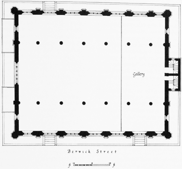
St. Luke's Church, Berwick Street, plan. Based on the Ordnance Survey, 1870–5, and a plan in the possession of the Church Commissioners.
The south end elevation was divided by pinnacled buttresses into three bays, conforming with the nave and aisles. In the middle bay was a large window of five lights with a traceried head, and in each side bay was a narrow single light. The west elevation was generally similar to the east, but had only one doorway, while the almost hidden north end was remarkable only for a small open belfry, rising above the apex of the gable.
Kemp House
This block was erected in 1960–2. It was built for Westminster City Council by Messrs. Wates Ltd., at an estimated cost of half a million pounds. The scheme was designed by the Council's Director of Housing, in association with L. C. Holbrook, of Messrs. Riches and Blythin. (fn. 81)
Kemp House is a noteworthy example of mixed development comprising offices, flats and shops. The building is steel-framed with a threestoreyed podium surmounted, towards the southern end, by a fourteen-storeyed tower faced with pinkish-yellow brick. Towards Berwick Street the podium is set well back behind a broad pavement, but above the shops in the ground storey projects a deep canopy which helps preserve the intimacy of the market area, an effect which is heightened by cantilevering the second and third storeys out over the pavement to form a wing at each end. A fuller description will be found in The Architect's Journal, 18 October 1961, pp. 675–687.
Brewer Street
Only Nos. 2–30 (even) Brewer Street are built on Colman Hedge Close; the general history of the street is described on page 118. The first houses on these sites were probably built in the 1660's and 70's along the southern boundary of the field and fronting on to a passage-way (shown in a map of 1664) (fn. 10) to the adjoining Pulteney property. In the 1670's this passage-way became the eastward arm of Sir William Pulteney's 'new way' (see page 118). Ogilby and Morgan's map of 1681–2 (Plate 3a) shows that it was a well defined street with houses along most of its north side.
This new street was at first known as Knaves' Acre from the close which flanked its southern side, but later became known as Pulteney or Little Pulteney Street. In 1937 the name Brewer Street was extended to include all the houses eastwards up to Wardour Street.
Following the grant of the long building lease of all Colman Hedge Close to Pollett and his associates in December 1685, the remaining vacant sites on this new street were sub-let for building and a number of new houses erected there. John Simmonds, blacksmith, and James Price, glazier, were two of the tradesmen who took up sites here. (fn. 82)
No. 12 Brewer Street
Formerly No. 5 Little Pulteney Street
No. 12 is a larger than average house, apparently dating from about 1750 but possibly earlier in its carcase. A modern shop-front almost fills the ground storey, its fascia largely concealing the brick sill-course to the first-floor windows. The upper part of the front is of plain brickwork, with two tiers of four evenly spaced windows, a few on the right retaining sashes with glazing-bars, all set in plain openings with plastered reveals and flat gauged arches. The return front to Walker's Court has also four windows in each storey, some of them blind and the rest with barred sashes. The soldier-course, the rudimentary cornice of projecting brick courses and the parapet are modern.
Green's Court
This court probably takes its name from Thomas Green, paviour, to whom a lease of part of the site was granted by Edward Wardour before December 1685. Three houses were built there by 1688. (fn. 82)
Peter Street
This street probably originated as a passage-way to the saltpetre house which was built about 1656 on a site between this street and Brewer Street. (fn. 12) The street name (which probably derived from this building) first appears in the ratebooks for 1675 and Ogilby and Morgan's map of 1681–2 shows buildings along the greater part of both sides of the street. After the grant of the building lease of 1685 to Pollett and his associates a number of new houses were erected there between 1686 and 1693. (fn. 20) The building tradesmen who took up leases include Thomas Husbands, painter, and John James and Abraham Bridle, carpenters. (fn. 83)
In 1720 Peter Street was described as 'a Street not over well inhabited', (fn. 22) and in the 1830's as 'a short dirty street, without any thoroughfare'. (fn. 84) By the late nineteenth century the buildings had become 'wretched hovels, and a disgrace to humanity'. (fn. 85) Most of the street has been rebuilt during the last hundred years and the earliest surviving houses are of the late eighteenth or early nineteenth centuries.
Nos. 2–4, 20–22 (consec.), and 28 Peter Street
Nos. 2 and 3 were built as a pair probably in the early nineteenth century, of brick since painted. Both consist of a basement and three low storeys, with a shop on the ground floor and one wide three-light window to the front room on the two upper storeys (segmental-headed at No. 2, flatheaded at No. 3, both with plastered reveals), and a parapet concealing the roof. No. 4 next door, two windows wide and four storeys high, carries the inscription 'JP1828' between the first and second floors.
Nos. 20–22 (consec.) form a four-storeyed terrace of three houses, each two windows wide, and resembling Nos. 33–36 Marshall Street. The ground floor, with thin pilaster-strips and meagre continuous entablature, was apparently planned for shop-fronts, but each contains only one domestic window. The top floor has been renewed. No. 23 has been rebuilt above the ground floor, which has the remains of a continuous range of small-paned shop windows. The cementfaced front of No. 28, three storeys high and three windows wide, has a pilaster-strip at the east end, above a nineteenth-century shop-front.
Peter Street Chapel
Demolished
In 1734 Dr. James Anderson and part of his congregation left the Scottish church in Swallow Street (see page 63) and established themselves in Lisle Street chapel, near Leicester Square. When they were unable to renew the lease of this building in 1755, the congregation, now led by Dr. John Patrick, acquired two houses in Peter Street and used their sites for a new church, described as 'a small neat building, with three galleries and conveniently fitted up with pews'. (fn. 86)
In 1815 it was listed as an independent chapel, (fn. 87) but later reverted to Scottish Presbyterianism. In the 1850's it was used by the Wesleyans, (fn. 49) but it evidently ceased to be used as a chapel in 1858, when all the internal fittings were offered for sale. (fn. 88) The chapel was situated on the north side of Peter Street, one door west of Hopkins Street, and later became the St. Luke's National School, (fn. 89) which was demolished in 1880 for the erection of a London School Board school (see below).
Pulteney L.C.C. School
This building was erected for the London School Board in 1880 by the builders Messrs. Wall Brothers of Kentish Town, from the plans of E. R. Robson, architect to the Board. The site had previously been occupied by a number of small houses and by St. Luke's National School. (fn. 90)
This is one of the plainer buildings designed by Robson for the London School Board. It is a single tall block of three storeys in yellow stock brick with red brick dressings. The windows have white-painted glazing-bars and the coved main cornice is painted white, the only other notable decorative element being the lofty arcade of shallow segmental-headed recesses with white keystones on the top storey, containing flatheaded windows. A two-storey cottage of the same materials stands west of the school.
Ingestre Place
In 1868 New Street and Husband Street were together renamed Ingestre Place after a block of artisans' dwellings known as Ingestre Buildings. These had been erected on the initiative of Lord Ingestre on a site fronting both these streets in 1853–5.
Only the east side of New Street formed part of Colman Hedge Close, the west side being part of Windmill Field (see page 137). The first houses on the east side were probably erected in the decade 1695–1705, following the development of the adjoining sites on the south side of Broad Street and the west side of Berwick Street. (fn. 20) In 1721 a house in New Street was taken by the vestry of St. James as a parish infirmary for sick and impotent paupers. It remained open until 1748 (see page 210).
Husband Street probably took its name from Thomas Husbands, painter, to whom Joseph Collens, one of James Pollett's associates in the development of Colman Hedge Close, granted several leases in 1701. (fn. 91) The buildings on the north side of the street were demolished in 1852 for the erection of Ingestre Buildings and those on the south side in 1880 for the London School Board school (see above).
Ingestre Buildings
This block of artisans' dwellings was erected through the initiative of Lord Ingestre (later nineteenth Earl of Shrewsbury) by the Metropolitan Association for Improving the Dwellings of the Industrious Classes. In 1852 the association took a ninety-nine-year lease of a large site which abutted on to the Lion Brewery on the north, and on New Street, Husband Street and Hopkins Street on its other three sides. This ground was covered by a quadrangle of dilapidated buildings, known as 'the Barracks', in the midst of which stood a cow-house full of cows and pigs. The site was then cleared and a new building was erected in 1853–5 at an estimated cost of £9000 (Plate 139b). The architect was Charles Lee. The new building, a plain four-storey block, with a few rusticated pilaster-strips and brick bandcourses above a dark entrance court-yard, did not meet with the approval of The Builder, which complained that it was overcrowded, lacked a playground and that the inhabitants were forced to close their windows to exclude the 'incense' from the adjoining Lion Brewery in Broad Street. (fn. 92)
Hopkins Street
Although it does not appear by name in the ratebooks until 1716 the original development of Hopkins Street probably took place in the 1690's, after the forfeiture of James Pollett's market licence in 1690 (see page 220). The street probably takes its name from Richard Hopkins, plasterer, to whom a lease of a site on the east side was granted in 1709. (fn. 93)