A History of the County of Cambridge and the Isle of Ely: Volume 10, Cheveley, Flendish, Staine and Staploe Hundreds (North-Eastern Cambridgeshire). Originally published by Victoria County History, London, 2002.
This free content was digitised by double rekeying. All rights reserved.
A F Wareham, A P M Wright, 'Burwell', in A History of the County of Cambridge and the Isle of Ely: Volume 10, Cheveley, Flendish, Staine and Staploe Hundreds (North-Eastern Cambridgeshire)(London, 2002), British History Online https://www.british-history.ac.uk/vch/cambs/vol10/pp334-341 [accessed 30 April 2025].
A F Wareham, A P M Wright, 'Burwell', in A History of the County of Cambridge and the Isle of Ely: Volume 10, Cheveley, Flendish, Staine and Staploe Hundreds (North-Eastern Cambridgeshire)(London, 2002), British History Online, accessed April 30, 2025, https://www.british-history.ac.uk/vch/cambs/vol10/pp334-341.
A F Wareham, A P M Wright. "Burwell". A History of the County of Cambridge and the Isle of Ely: Volume 10, Cheveley, Flendish, Staine and Staploe Hundreds (North-Eastern Cambridgeshire). (London, 2002), British History Online. Web. 30 April 2025. https://www.british-history.ac.uk/vch/cambs/vol10/pp334-341.
In this section
BURWELL
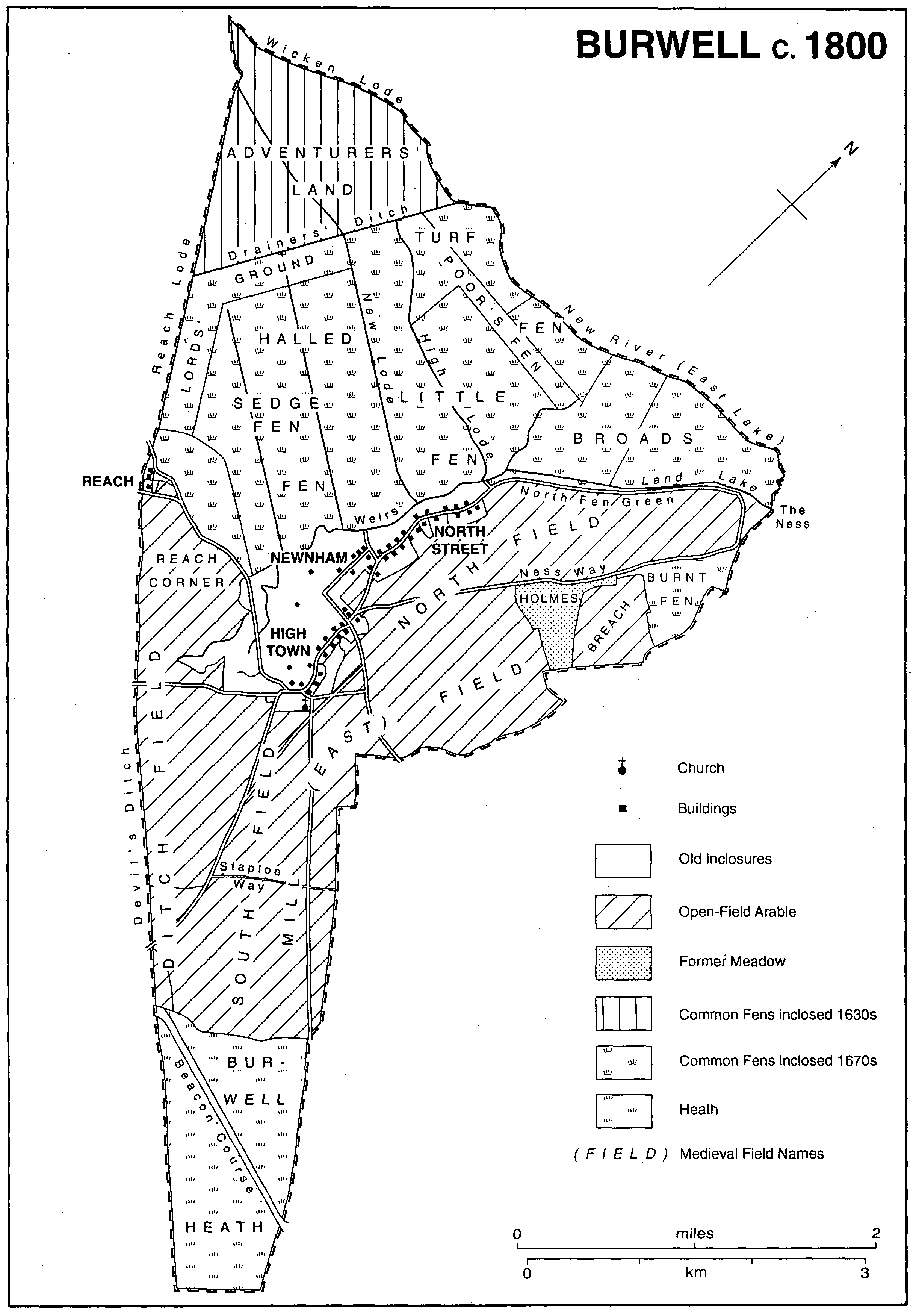
The parish of Burwell (fn. 1) lies by the Cambridgeshire-Suffolk boundary, almost four miles (6.5 km.) north-west of Newmarket and ten (16 km.) north-east of Cambridge. Approximately triangular, with a narrow southern extension, (fn. 2) Burwell stretches for c. 7 miles (12 km.) between an ancient watercourse running west into the river Cam on the north, and the line of the Icknield way on the south-east. It covered 7,446 a. until 346 a. on its western edge was detached in 1961 to form part of the new parish of Reach, which surrounds a hamlet that had previously lain partly in Burwell parish, thereafter reduced to 2,837 ha. (7,010 a.). (fn. 3) To the south-west Burwell is bounded by the Devil's Ditch, apparently 6th-century, and Reach Old Lode, perhaps originally Roman. (fn. 4) Probably since medieval times, Burwell's northern boundary has run for nearly four miles along a stream embanked when the Bedford Level was drained in the mid 17th century. That gently curving watercourse, known by 1677 as the New River, (fn. 5) joins at its west end the possibly also Roman Wicken Lode. The western part of the New River, slightly wider than the rest and called by the 1750s Monks' Lode, may, however, be medieval. (fn. 6) Just south of Wicken Lode's west end Burwell's boundary curves slightly north of the 19th-century Burwell Lode; that curve may indicate the line which Reach Lode followed before its modern straightening. On the east the boundary at first follows an irregular course, bending gradually southwestward where Burwell's former open fields met those of Exning (Suff.), to pass near Burwell village before turning south-east again to follow a straight route across heathland which eventually became part of Newmarket racing grounds.
That south-east end of Burwell lies upon the Middle Chalk, the land further north upon the Lower Chalk, including south-east of the village a belt of Totternhoe Stone, which has been quarried in places. The gault north-west of the chalk is largely overlaid, except near the New River, with peat, with a few islands of river gravel. (fn. 7) Burwell Heath, part of which reaches over 50 m. in the far south-east of the parish, then dips slightly before it extends northwestward for almost a mile upon high ground almost level at c. 30 metres. The ground then declines very gently for a mile, before dropping sharply to where the long village street stretches north-south at c. 10 m. Beyond it the fen to the west is again virtually level. Other high ground rising to over 15 m. occupies the north-east of the parish. Until Burwell was inclosed in 1815, the south-eastern heathland provided common and the remaining upland east and south of the village served as open fields, while the fen, not effectively drained until c. 1850, was also common until its formal division into several ownership between 1660 and 1680. (fn. 8)
Burwell's uplands had few watercourses in modern times, although a stream called Warbraham water once broke out every few years near the modern Warbraham Farm and flowed north, partly through Exning, to enter the New River at its east end. (fn. 9) An Anglo-Saxon fort which probably gave the village the name, 'spring by the burh', recorded from the late 10th century, (fn. 10) may have stood, preceding the 12thcentury Burwell castle, near Spring close west of the church. A stream rising there combines with other minor watercourses to form further north a larger one once called the Head lode, (fn. 11) but from the 1670s the Weirs. (fn. 12) Running parallel to the village street, that stream formed until modern times the effective boundary between the upland and the fen. (fn. 13) Before the lodes were created in Roman times that stream and others rising further north, including the Head lake mentioned c. 1580-1610, and the East and Land lakes still recorded in the 1670s, (fn. 14) had probably flowed west through the fen. A curving lode, possibly medieval and called the High lode by 1580, (fn. 15) but renamed the old lode in the 1670s, (fn. 16) runs west from the north end of the medieval village, where it met the navigable Weirs. It was superseded from the mid 17th century by the modern Burwell Lode, cut a little further south, still described as the new lode 1677 × 1699. (fn. 17) That modern Lode after initially leading northwest bends west after 2.5 km. to receive other straight parallel drainage ditches, also made in the 1670s and called by 1800 Newnham and High Town lodes. (fn. 18) Burwell Lode then again turns north-west to meet Reach Lode and follow a wide, straight cut, improved after 1840, into the river Cam, south of Upware. After 1700 the land surface in Burwell fen was much lowered, partly by continual peat digging: about 1850 the lodes, drainage channels, and droveways stood out over much of the fen above a 'dead flat water level'. (fn. 19)
Burwell c.1800
In the north-west of Burwell fen the peat covered in places the submerged remains of a prehistoric forest of bog oaks. During the Second World War many of their huge trunks were blown up to make the land cultivable. (fn. 20) Traces of prehistoric human activity include worked flints from the Palaeolithic period onwards. One concentration of flint tools from a slight rise in the fen, 1.5 km. west of the village, suggests that there was a small settlement there from late Neolithic times. (fn. 21) Several Bronze Age weapons and tools have been found, mostly in the fen, partly under the peat; of two Late Bronze Age founders' hoards, one comes from near Burwell church. (fn. 22) Ten or more Bronze Age round barrows once stood on and near Burwell Heath. Among them was a group of four south of Portland Farm, each c. 70 ft. across including its ditch, which were still visible in the early 19th century; the last of them was destroyed in the 1880s. Others on arable closer to the village had probably already been ploughed down before 1800. In two on the heath, destroyed in 1807, were found a cremation and two inhumations with beakers. (fn. 23)
There was probably a substantial RomanoBritish settlement near the modern village. Broken roof tiles and painted wall plaster possibly from a farm of that period were found with pottery fragments in 1935 under Burwell castle. Further north, traces of ancient British field ditches were noticed in 1969 with pottery sherds of the 2nd to 4th centuries in a field near Parsonage Lane, where a hoard of Roman bronze vessels was discovered in 1966. Previous finds in the fen included pewter dishes, one found close to the north-west end of Reach Lode, from near which has also come evidence of the passage of merchandise. (fn. 24) Other Roman structures, from which fragments of tiles and stonework found in 1928 may have come, may have stood close to an Anglo-Saxon cemetery discovered c. 1885 near clunchpits east of the village's south end and excavated, 1924-9. That cemetery, whose presence suggests settlement within the parish before 700, probably dated from the early Christian period. It contained at least 130 burials, mostly oriented, almost all adults; over 50 were without grave goods, few of the rest were weaponed or richly equipped. (fn. 25) In 1071 Hereward's men from the Isle of Ely burnt the village of Burwell. (fn. 26)
In 1086 Burwell was inhabited by c. 50 peasants with 10 servi. (fn. 27) By 1279 there were c. 175 tenants (fn. 28) and in 1327 66 taxpayers. (fn. 29) In 1377 462 people paid the poll tax. (fn. 30) The population may have doubled between the 1560s and the 1620s. (fn. 31) Some 600 communicants were reported in 1603 (fn. 32) and 566 potential adult church-goers in 1676. (fn. 33) In the 1660s and 1670s between 180 and 200 dwellings were occupied, of which in 1666 c. 145 had only one or two hearths, barely 20 four or more. (fn. 34) Save for a possible dip in the 1670s, numbers probably remained close to the level reached by 1640 until c. 1710, then fell by up to a third. That reduced level was maintained between the 1720s and the 1760s before growth was resumed from the 1770s. (fn. 35) From c. 1,250 in 1801 the population grew, most rapidly between 1811 and 1831 and in the 1840s, to 1,668 by 1831 and a peak for the 19th century of 2,040 in 1851. It then settled, save for a decline c. 1860, at between 1,950 and 2,000 until 1900. Thereafter numbers increased slowly to 2,257 in 1931 and 2,364 in 1951 before extensive new building in the 1960s produced a rise of c. 1,300 to 4,032 in 1971. From 4,223 in 1981, they rose more slowly to 4,628 in 1991. (fn. 36)
Until the 19th century settlement in Burwell was almost entirely confined to the long village street. (fn. 37) The inhabited area probably extended northwards from an early nucleus on relatively higher ground at the south end, called High Town by 1600, (fn. 38) near the two parish churches: the one which survives stands amidst an oval area with lanes within it, and has to the south a green, probably called by 1320 South green; the other church once stood just north-east of the oval. (fn. 39) Possible late Anglo-Saxon settlement in Spring close just to the west was obliterated by the erection there in 1144 of Burwell castle. (fn. 40) From High Town the high street (fn. 41) lined with dwellings leads due north past Stocks Hill, possibly recorded as the 'stocks green' c. 1645, to another green at Pound Hill, claimed as parish property in 1969. (fn. 42) The parallel lane, now called Mill Lane, once uninhabited, which formed a back lane east of the street, continues a winding lane east of the original oval block of dwellings.
Beyond the high street's end lies the raised Causeway, mentioned by 1575, (fn. 43) still grazed by cattle in the 1640s. (fn. 44) Four rows of ancient elms lining it by 1850 led to a 'cross' of trees at its north end. (fn. 45) It runs slightly north-west across a gap uninhabited before 1815 (fn. 46) to another settlement, curving gradually north-eastward, called from 1350 North Street. (fn. 47) That area was probably developed from the 13th century to provide access by water for villagers dealing in, or exploiting by boat, locally grown produce, including that of the fens: (fn. 48) from the early 14th century to the mid 15th the fen waterways carried corn from Ramsey abbey's Burwell manor to the abbey. (fn. 49) By 1320 Burwell's North End was populous enough to need its own aletaster. (fn. 50) On North Street, in contrast to the often wide closes around dwellings in High Town, the older houses, most continuous on the west side, stand end-on at the street end of long narrow crofts, (fn. 51) sometimes with outbuildings for storage further back. Those crofts run down to private landing places on the Weirs, (fn. 52) which there bend east to run eventually only 150 metres west of the street. At the south end, further from the water, some of North Street's houses have individual channels cut to run east from the Weirs. (fn. 53) For two thirds of its length North Street has, behind the scattered dwellings on its east side, another winding back lane, sometimes called after 1840 Silver Street. (fn. 54) Beyond the northern town's end, mentioned in 1582, of North Street, (fn. 55) squatters, 'typical fenmen', had by 1840 built six 'hovels' west of the Weirs near Goose Hall, one occupied in the mid 19th century by a local wise woman. (fn. 56)
Just west of the south end of North Street another planned development, presumably medieval, called by 1440 Newnham, (fn. 57) stands close to Burwell's ancient common hythe, 600 ft. long, mentioned by 1486. (fn. 58) Newnham has three narrow parallel lanes, mostly empty of housing in 1840, bounded by wider perimeter ones. In the later 19th century dwellings there were mostly humble wattle-and-daub, sedgethatched cottages. (fn. 59) The lane on the northern edge, leading along the hythe, was called by 1860 Hythe (Bridge) Lane. (fn. 60) From Newnham's east and west ends two lanes, that on the east called by 1671 Dark lane, (fn. 61) which provided before 1815 the main route for wheeled traffic, (fn. 62) lead south towards the site of the castle. Along the western lane nearest the fen edge, the modern Low Road, former manorial and rectorial farmsteads, some moated, stand amidst extensive closes. (fn. 63) Those lanes are linked to the north end of High Town by Parsonage Lane, established by c. 1410, (fn. 64) beside which cottages stood by the 18th century, (fn. 65) and further south by Hall Lane. (fn. 66) About 1840 there were probably c. 90 houses standing in and around High Town, c. 100 at North Street, and c. 30 at Newnham. (fn. 67) In 1861 the high street at High Town and its adjoining lanes had c. 125 of the dwellings in the village, North Street c. 150 and Newnham c. 60 more. (fn. 68)
Few houses survive in the village from before 1600, (fn. 69) but from the 17th century there remain some ten at High Town, with six more from the 18th. The earlier houses there, often onestoreyed with dormers, are mostly built, like some later ones, of locally cut clunch blocks; one or two were partially timber-framed. By the 18th century a few larger houses there were given brick fronts, though still having clunch side walls, among them the five-bayed Ramsey Manor with its segment-headed windows and pedimented doorcase. Few old houses remain in Newnham, although the farmhouses to its south include two of the 17th century. Tunbridge Farm, perhaps so named by 1860 from the Tunbridge (possibly the formerly (S)tonebridge) water nearby, mentioned in 1815, (fn. 70) standing within a moat, had a brick range added by 1700 at right angles to its original clunch northern one. Both older floors of that range, possibly the parlour wing of an earlier house, still have mullioned and transomed windows on three sides, and, inside, a reset low-arched 16thcentury clunch fireplace.
Along the west side of North Street stands a long line of originally 17th-century houses, many still thatched: almost 20 out of the 26 recorded in the 1960s were timber-framed, the others of clunch. (fn. 71) In the 18th century several were extended or cased in brick or clunch. Some of those houses were derelict or demolished by 1990. (fn. 72) The few houses erected 1700-1820 which survive there were mostly of clunch, dressed or fronted in brick. Of the 17th-century ones all but eight are single-storeyed with dormered attics, often to a customary local plan, which allowed parlour, kitchen, stairs, and storerooms on each flank to be supervised from a central 'house place'. (fn. 73) Many retain original moulded or chamfered beams; one near the south end has a four-centred stone fireplace and panelling possibly remade from 18th-century pews. One or two received in the 18th century higher wings, one in brick, standing along the street. About 1800 one was given, on its south entrance front, a symmetrical brick façade with bay windows, with reeded pilasters and Gothick glazing.
The early 19th century saw the building in High Town of one or two farmhouses, one in 1830, with standard three- or four-bayed, sashwindowed, brick or clunch fronts, along with rows of three or four cottages. (fn. 74) After inclosure in 1815 other farmsteads with dependent cottages, the earliest being at Ditch and Burwell Heath, later Warbraham, farms, were built south-east of the village on former open-field land. (fn. 75) Building along the Causeway began in the 1830s: (fn. 76) initially mostly single houses went up, ten by 1841, on the small plots on the northeast side allotted in 1815 for common rights. (fn. 77) By 1871 there were c. 30 dwellings there. (fn. 78) Later four long terraces to uniform design, each of 5-10 cottages, in Burwell white brick, trimmed in red, one dated 1897, were built along the south-west side. Several farms on the upland and along Ness Road to the north-east had been built by the 1860s, while small farmsteads and cottages, probably numbering thirteen by 1861 and twenty by 1881, were established beside the fen droveways. (fn. 79) Many 19th-century cottages survive along the village streets. The total number of inhabited dwellings in the parish grew from c. 280 in the 1820s to c. 450 by the 1880s, when over 30 others were empty. (fn. 80) By 1910, out of c. 540 dwellings in the parish, (fn. 81) there were altogether c. 75 houses and c. 250 cottages in and around the village, of which High Town and North Street each had c. 110 dwellings, the Causeway c. 50, and Newnham c. 45 others. (fn. 82)
Burwell village largely retained its traditional elongated shape until the mid 20th century, although the number of houses gradually rose from 567 in 1931 to 754 by 1951, (fn. 83) partly through ribbon building from the 1920s along roads leading north-eastward and southeastward from the southern end of the Causeway, and along the Swaffham road. (fn. 84) The village received piped water, replacing pumps, after much dispute, in 1939. (fn. 85) Growth was most rapid in the 1960s; by 1972 the village sewerage system installed in 1961 already needed expansion. Apart from infilling along the old streets, many of the 175 new houses built in the 1950s and of the 600 added 1960-72 (fn. 86) stood in two triangular areas east of High Town and North Street. Some lay along the earlier roads bounding those areas, which run south-east and north-east from those streets, others on the newly laid out avenues and closes, partly on former allotments, surrounded by those roads. Other new housing estates, partly still under construction in the early 1970s, lay within a densely built network of new closes extending southwards from Newnham towards Spring close, which envelop the previously empty lanes west of the Causeway and High Town. (fn. 87) Further building was restrained after 1972, the old hearts of High Town and North Street being made conservation areas in 1973, although infilling was still allowed. (fn. 88) By 1991 there were c. 1,950 occupied dwellings. Especially east of North Street the new building included many council houses; the first twelve were built c. 1920. In 1981 council property comprised a fifth of the housing in the parish and included sheltered housing for old people off Ness Road. Sales reduced it to under a sixth by 1991. (fn. 89) From 1974 there was a 7-a. caravan site off North Street. (fn. 90)
Burwell's long-distance communications were partly provided by the ancient way past the southern edge of the parish, which formed part of the Chesterford-Newmarket turnpike between 1724 and 1870, (fn. 91) and by other parallel tracks running north-east across Burwell heath through gaps in the Devil's Ditch. (fn. 92) The village was also linked to its neighbours by several fieldways: among them were (New) Market and Swaffham ways, running south and west, from the south end of High Town; others, including Ness way leading towards Fordham, ran east and north from its north end. (fn. 93) At inclosure most of them were left to follow their previous slightly curving courses or only marginally straightened, although a long straight road was set out south-eastward towards Burwell heath. (fn. 94) Scotred lane, recorded by 1650, curving northwest towards Reach from the south of High Town, probably passed over a stone bridge mentioned in 1581, which then apparently stood amidst meadows and crossed a watercourse west of High Town. (fn. 95) Further north, from the 17th century, access was available through a lane west from North Street over Anchor bridge, a drawbridge named after a nearby public house, to the fen droveways, which themselves crossed the lodes, to permit navigation, only by two drawbridges. (fn. 96) The droves were concreted only in the 1940s. (fn. 97)
From 1883-4 Burwell had its own railway station south of High Town on the newly built Cambridge-Mildenhall railway line. (fn. 98) Closed to passengers from 1962 and to goods in 1965, the station was demolished in 1967, as was the adjoining railway bridge in 1973, the line being removed. (fn. 99) In the mid 1970s a section of the Newmarket bypass was built across the northern edge of the former heath. (fn. 100) From the 1920s Burwell had a bus service worked by a company, formally established c. 1930, which had been built up from a taxi service by the Mansfield family, originally cycle repairers. From 1924 they ran buses, eventually providing daily services on routes through Burwell between Soham and Newmarket, also to Cambridge and to Bury St. Edmunds (Suff.) and the seaside. In 1979 the Burwell Bus Company was taken over by the Eastern Counties bus company. (fn. 101)
Burwell had resident doctors from the 1790s, two from c. 1910. (fn. 102) Charles Lucas (1853-c. 1938), (fn. 103) who took over c. 1890 the practice started on the high street in the 1840s by his father Thomas (d. 1895), (fn. 104) interested himself in local antiquities and archaeology. (fn. 105) E. A. R. Ennion, who served c. 1925-45 in the other practice, working from the substantial Edwardian Harlech House at the south end of High Town, studied and depicted fenland natural history. (fn. 106) In 1921 a district nurse's cottage was built at Pound Hill as a war memorial. (fn. 107) Doctors were still based in the village, one retiring in 1979 after 34 years' service, in the late 20th century. (fn. 108)
In the early 14th century Burwell was usually served by 10-15 alewives. (fn. 109) Of 13 recorded in 1400 half brewed no more than 6-20 times a year. (fn. 110) From the 1760s (fn. 111) the village had one substantial public house in High Town, (fn. 112) the White Horse, where a newly founded lodge of Oddfellows dined after their procession in 1850. (fn. 113) Enlarged in brick towards the street in 1849, with an assembly room at one side added soon after, and a bowling green, (fn. 114) it was styled a hotel by the 1930s. It closed in 1975. (fn. 115) The Five Bells, open in a mid 18th-century tiled, redbrick house by 1850, when a whitebrick clubroom was added, (fn. 116) survived in 1993, along with the Crown, recorded from the 1930s. Of the two inns recorded from the 1760s on North Street, the Anchor and the Rose, only the former, which had hosted annually dinners of a branch of Ancient Shepherds founded in 1846, which had c. 100 members c. 1870 and still flourished c. 1900, (fn. 117) was still open in 1993. The Queen's Arms, also on North Street, in a one-storeyed, timber-framed house, dated 1587, had closed by 1976. (fn. 118) The Fox, open at the north end of the Causeway by 1764, in a 17th-century, timber-framed, house, whose 18th-century western part was rebuilt c. 1850, (fn. 119) was still open in 1993, despite arson attacks. (fn. 120) In the 1890s a Conservative club started by 1888 had met there. (fn. 121) The William IV with its white brick front, built as an inn in the 1830s where Ness Road branched off from the Causeway, (fn. 122) apparently closed c. 1992. (fn. 123)
The village camping land was mentioned in 1583. (fn. 124) The village feast, by 1750 held on Pound Hill at Whitsun, survived into the late 1860s, (fn. 125) while a summer cottagers' flower show started by 1861 still flourished in the 1870s. (fn. 126) A flower show was revived in 1966. (fn. 127) Cricket matches were recorded from the 1840s. (fn. 128) The parish recreation ground acquired in 1897 (fn. 129) thenceforth provided space for cricket, (fn. 130) also for tennis from 1903, (fn. 131) rifle practice c. 1903, (fn. 132) and football from 1900. (fn. 133) From the 1850s Burwell had its own village band, (fn. 134) after 1918 intermittently revived into the 1990s as the Excelsior Band. (fn. 135) Plough Monday ceremonies were revived from the 1960s. (fn. 136) In 1914 John Gardiner, a clunchpit owner, left £1,000 for building a village hall. The white-plastered Gardiner Memorial Hall, trimmed in red brick, built east of the high street and opened in 1915, (fn. 137) was often used from the late 1910s for showing films. (fn. 138) At the village college, where a youth centre had been started in 1971, (fn. 139) a large sports and social centre was built and equipped in stages between 1983 and 1986, (fn. 140) while a swimming pool, made in 1986, (fn. 141) succeeded the former bathing place on the Weirs, in use from 1908. (fn. 142) Between the 1960s and the 1990s the well populated village saw established a large variety of sports and social clubs, (fn. 143) besides the British Legion branch started in 1921 (fn. 144) and a Women's Institute of 1936. (fn. 145) A Burwell Society, started in 1961 to uphold local rights of way, was revived in the 1980s as a group devoted to preserving local amenities. (fn. 146) The windmill east of High Town had its own preservation trust, formed in 1975, (fn. 147) which restored it between 1979 and 1981. (fn. 148) Next to it a museum of local crafts and domestic life was opened in 1992 in a 17th-century timberframed barn obtained from Suffolk and re-erected in 1988; other barns were brought to that site from Brinkley, and from Streetly in West Wickham. (fn. 149)
In September 1727, when 140 villagers crowded into a straw-filled barn to see a travelling puppet show, the candle of an excluded spectator, peering from next door, started a fire. Many of the audience were burnt, or crushed to death against the barred doorway. The charred remains of c. 80 victims, two thirds children, were buried in a common grave in the churchyard still marked by a stone with a winged and flaming heart. (fn. 150)
Edward Ball, later FitzBall (1792-1873), son of a Burwell farmer, was noted in his time, 1825-55, as a melodramatist, librettist, and song writer. (fn. 151) Edward Ball (1793-1865), the parish's most prosperous merchant in the early 19th century, (fn. 152) although a dissenter and opposing church rates, was thrice elected between 1852 and 1863 as Tory Protectionist M.P. for Cambridgeshire. (fn. 153)
From the 1660s Burwell heath was crossed by the last section of Newmarket's Beacon Course, running south-east to where the Rowley Mile stand at the effective modern end of the course was built c. 1810, eventually straddling the parish boundary. (fn. 154) At inclosure the Jockey Club threatened to obstruct the bill in parliament, demanding in 1814 that the course be formally allotted to it. It was fobbed off with permission to acquire the heathland involved, 17½ a., by exchange in 1817. (fn. 155) By 1830, however, up to 400 a. of that heath had been bought by the racing fourth duke of Portland (d. 1854). (fn. 156) His 246-a. holding in 1840 included much of the later Great and Little Portland farms, which were sold in 1881 from the Dobedes' Exning House estate. They were subsequently purchased and before 1895 sold by the Jockey Club, along with 73 a. of the heath. By 1840 the club itself owned another 480 a. of the heath south of the racecourse. (fn. 157) In 1910 it had in all 650 a. there, land used in the 20th century for racing and training gallops. (fn. 158)
BURWELL CASTLE.
In 1144 King Stephen, confronted by the rebellion of Geoffrey de Mandeville, earl of Essex, began to construct at Burwell one of the chain of forts intended to confine Geoffrey's depredations wrought from Ramsey abbey (Hunts.). That August Geoffrey, coming to besiege the 'newly built' castle at Burwell, was mortally wounded by an archer while reconnoitring it unhelmeted. (fn. 159) The castle was thereupon left unfinished. The surviving earthworks, excavated in 1935, in Spring close west of St. Mary's church, comprise a rectangle, 260 by 160 ft. A moat up to 9 ft. deep and 100 ft. wide, which surrounds the perimeter, was never completed, natural chalk remaining in places on its north, south, and west sides. Traces of the tracks used to carry the chalk up to large spoilheaps surviving to the west and north are still visible in the sides of the moat. Other chalk spoil dug from it in 1144 was being used to make the castle's interior platform. Only on the eastern side were there foundations of a curtain wall in flint-faced clunch, along with footings of a bridge across the moat. A rectangular tower, north of the bridge, 21 by 15 ft. internally, with similar walling 5 ft. thick, buttressed at the corners and slightly projecting, had remains of two garderobes in its north wall. Fragments of leaded stained glass and clunch masonry, possibly 14th-century, (fn. 160) suggest that the walled part may later have been used for some ecclesiastical purpose. (fn. 161) The last section of clunch curtain walling surviving on the east c. 1805 collapsed c. 1930 through fire brigade practice. (fn. 162) In 1983 the parish council acquired the site with the surrounding 11-a. Spring close, for the villagers' recreation, which once included motor cycle scrambling only stopped in 1976, and for archaeological preservation. (fn. 163)