A History of the County of Cambridge and the Isle of Ely: Volume 10, Cheveley, Flendish, Staine and Staploe Hundreds (North-Eastern Cambridgeshire). Originally published by Victoria County History, London, 2002.
This free content was digitised by double rekeying. All rights reserved.
A F Wareham, A P M Wright, 'Soham', in A History of the County of Cambridge and the Isle of Ely: Volume 10, Cheveley, Flendish, Staine and Staploe Hundreds (North-Eastern Cambridgeshire)(London, 2002), British History Online https://www.british-history.ac.uk/vch/cambs/vol10/pp489-499 [accessed 30 April 2025].
A F Wareham, A P M Wright, 'Soham', in A History of the County of Cambridge and the Isle of Ely: Volume 10, Cheveley, Flendish, Staine and Staploe Hundreds (North-Eastern Cambridgeshire)(London, 2002), British History Online, accessed April 30, 2025, https://www.british-history.ac.uk/vch/cambs/vol10/pp489-499.
A F Wareham, A P M Wright. "Soham". A History of the County of Cambridge and the Isle of Ely: Volume 10, Cheveley, Flendish, Staine and Staploe Hundreds (North-Eastern Cambridgeshire). (London, 2002), British History Online. Web. 30 April 2025. https://www.british-history.ac.uk/vch/cambs/vol10/pp489-499.
In this section
SOHAM
The parish of Soham, (fn. 1) with its 5,260 ha. (12,999 a.) (fn. 2) the largest in Cambridgeshire outside the Isle of Ely, lies on the border between the Isle and the southern part of the county, at its north-eastern angle. (fn. 3) Soham village stands five miles (8 km.) south-east of Ely and six miles (9.5 km.) north-west of Newmarket, and some twelve miles (19 km.) north-east of Cambridge. The parish, an irregular quadrilateral with curving sides, also including two northern projections, (fn. 4) stretches westward to touch the lower Ouse; there it takes in the ancient hamlet of Barway, considered a part of Soham since the 13th century. (fn. 5) Soham's eastern and western boundaries (fn. 6) largely follow existing or former curving fen watercourses, the former eventually reaching the north end of Isleham Lode. To the north Soham is divided from Ely parish by the Crooked Drain, so called by the late 19th century, (fn. 7) which curves south to make a large indentation between the two projections. In the south-east the existing boundary with Fordham, whose northern part was still reckoned in the 1650s to lie within the jurisdiction of the main Soham manor, (fn. 8) was only finally established in the mid 17th century when the hitherto intercommonable Soham and Fordham moors were allotted in severalty. (fn. 9) Further west the modern southern boundary follows the division for tithe collection, which ran in places across shared open fields and even furlongs. (fn. 10)
Most of Soham parish lies within the fens. It is virtually level at well below 10 m., lying in its far south-east upon the Lower Chalk, but mostly upon gault, with greensand and Ampthill clay in its far west around Barway. (fn. 11) The gault is exposed south-west and north of the village, upon land later used as arable, but elsewhere is overlaid with gravels east of the village and with alluvium both to its north and to its west, where the former Soham Mere lay. Beyond an area of peat north-west of the Mere rises the 'sugarloaf' Henny Hill, a name in use by 1086 and perhaps derived from its position amidst wildfowl-haunted fens. Slightly higher, rolling ground in the south-east of the parish gave space for some open fields, while a rise to almost 10 m. further north provided a site, just north of a river crossing, for the medieval village, so named, like Barway, from its situation by or amidst the fenland waters. (fn. 12)
The river, effectively the lower portion of the Snail running north from Fordham, from at least the 17th century followed a perhaps diverted course bending south-west at the north end of the modern Fordham moor. Its water then ran along a line curving west and then WNW. south of Soham village and eventually, after bending almost north-west near Barway hamlet, fell into the Ouse. Close to the village its flow turned west near the south end of the main street at the Brook dam, so styled from the 17th century. (fn. 13) Then, and perhaps by 1400, the dam gave its name to that section of the stream, (fn. 14) which probably ran there on an irregular ancient course. To the north-west of the village and in the south-east of the parish, where in the 17th and 18th centuries it was named locally the Clipsall river, (fn. 15) its straighter lines were probably due to artificial improvements. By the 1660s, partly to assist navigation, the Bedford Level Commissioners had also made some improvements to the lower course of the river, (fn. 16) sometimes styled c. 1700-30 the Soham river, (fn. 17) but usually called Soham Lode from the 1720s. (fn. 18) By 1760 a bridge provided access to Barway. (fn. 19) The western part of the lode runs north-east of the large but shallow Soham Mere, recorded from the 11th century, (fn. 20) whose 1,370 a. (fn. 21) remained undrained throughout the Middle Ages. Its draining, first attempted c. 1670, was not finally effected until after 1750. (fn. 22)
The fens further north, also subject to periodical inundation (fn. 23) and reckoned in 1279 to extend for ten leagues by two, (fn. 24) were devoted to common pasture, mainly of cattle, until their division in the 1660s. At that period there were set out both the main and the smaller straight drainage ditches which run through the fens, largely following property boundaries then laid down. Higher ground north and south of the village accommodated two groups of open fields, never formally inclosed, whose traditional triennial rotation gradually ceased from the late 18th century. In the late 20th century Soham became a centre for light industry. (fn. 25)

Soham in the late 20th Century
Settlement and domestic buildings.
There is evidence of human activity since the Bronze Age. The parish has yielded bronze weapons and tools, and some pottery, including two urns found near an uncremated skeleton in Clipsall field. (fn. 26) Early Iron Age remains are scantier, (fn. 27) but Late Iron Age and early Roman pottery was found c. 1980 south-east of the village, with three (destroyed) ring-ditches. Pottery and tesserae have been recovered from a probable Roman dwelling south of the village, while earthworks, possibly field boundaries, on New Fordey farm south of Barway suggest the existence of other habitations nearby. (fn. 28)
Soham was certainly inhabited in AngloSaxon times, its people being apparently buried in two separate cemeteries. One, on the site of the modern churchyard, has produced cruciform brooches, perhaps mid 6th-century. Another, which lay partly within the modern burial ground off the Fordham road, was partially excavated in 1931. Although probably pre-Conversion, its 25 burials consisted largely of poorly furnished inhumations. (fn. 29) Excavations off Pratt Street c. 1990 have revealed post-holes of dwellings with Saxo-Norman and later pottery from an apparently substantial settlement, besides cropmarks. (fn. 30) A story about St. Felix's relics (fn. 31) suggests the existence of such a settlement around a minster church by the early 11th century.
Soham's population, which in 1086 included 60 peasants with 5 servi, (fn. 32) had grown by 1279 to comprise c. 120 landholders, besides six fishermen at Barway. (fn. 33) In 1327 the fifteenth was levied on 88 residents. (fn. 34) In 1343 c. 600 villagers were called out to help harvest crops for the main 'Duchy' manor. The Black Death reached Soham in spring 1349, probably killing 14 out of that manor's 90 customary tenants by Easter (12 April) and 17 more by Whitsun (31 May), while two thirds of its inhabitants died early in June. In 1352-3 lack of tenants for 23 of its holdings was ascribed to the pestilence. (fn. 35) In 1377 the poll tax was paid by 382 adults, (fn. 36) and in 1523-4 the subsidy was assessed on c. 95 people. (fn. 37) In 1552-3 tithe-paying householders numbered 330 married couples, 40 widows, and 15 single men, and there were possibly 120 servants in husbandry living in. (fn. 38) In 1603 the curate reported 800 communicants, (fn. 39) the beginnings of an increase in population which may have risen by a seventh, possibly to well over 1,600, by the mid 17th century. (fn. 40) In 1648 there were c. 185 rateable households. Of c. 165 taxpayers assessed in the parish that year, only 15 came from Barway, (fn. 41) figures comparable with the number of ancient commonable messuages reported in 1666, 263 at Soham, 15 at Barway. (fn. 42) In 1666 up to 310 dwellings in the parish were inhabited, (fn. 43) while in 1676 c. 550 adults were reported. (fn. 44) Numbers, after remaining near their mid 17th-century height into the early 18th century, may have fallen back in the 1730s and 1740s before renewed growth from the 1760s (fn. 45) raised them to over 2,000 by 1801. A rate of increase of 350-400 per decade between then and 1821 briefly doubled in the 1830s. In 1841 the total population stood at 4,091. In 1851 it reached its 19th-century peak of 4,706, of whom c. 1,950 lived outside the village in 1851, and all but 391 had been born in the county. (fn. 46)
Pressure of population was relieved by emigration in the early 1850s: numerous villagers departed, not only unemployed labourers but small farmers. In 1851 10-12 families went at a time, leaving 60 houses empty by that August. (fn. 47) Early in 1852 up to 200 people went out, (fn. 48) mostly for Australia or America. By 1861 the population had been reduced to c. 4,280, a level maintained until the 1870s before falling below 4,000 by 1881. A slow recovery brought numbers back to c. 4,700 from the 1910s to the 1930s. The population was only 120 higher in 1951, but after slow growth in the 1950s rose steadily from the late 1960s, partly through immigration to occupy extensive new housing estates. It reached 5,431 in 1971, 6,571 in 1981, and 7,690 in 1991, (fn. 49) of whom c. 200 dwelt at Barway. (fn. 50)
The medieval village, like its early modern successor, (fn. 51) probably stretched from south to north amid extensive closes and crofts along a long street inclined slightly north-westward with occasional bends, which from the 12th century formed part of a route from Fordham to Ely. In the 1650s, when the village contained c. 200 houses, the most thickly inhabited part of the street was Churchgate Street, so called by the 1460s. (fn. 52) Two thirds of its fifty houses were then crowded along its east side; the western side of that street was less full, especially in its central portion south of the church, which had no back lane. East of that street ran a curving back lane called by 1580 Paddock Street, (fn. 53) which extended north to Cross Green, so styled by 1759, (fn. 54) where it entered Pratt Street, so named by 1466, (fn. 55) upon which twenty houses stood in 1656.
Further north still Hall Street, so named by 1460, (fn. 56) lay beyond a bend north-eastward where no houses stood in 1656 and few even in the 1840s; (fn. 57) in 1656 it had c. 20 houses with five more beyond a further bend. To the west lay its back lane, Thorn Street, in being by 1450 when it was called Cobb Street, and still inhabited 1510 × 1560, (fn. 58) but empty by 1656. Hall Street's northern extension, already called in 1628 by its modern name, Townsend, (fn. 59) was also virtually uninhabited in 1656.
South-east from Churchgate Street a causeway led to the slightly isolated Brook Street, mentioned from the 13th century, (fn. 60) which in 1656 had 30 houses, standing almost equally on both sides. To its west the main street crossed the brook by a bridge standing by 1260, (fn. 61) called the Stone bridge from the 17th century; (fn. 62) it was then continued southward by Sand Street, so named by 1350. (fn. 63) In 1656 Sand Street had four houses by the bridge, but not many others before the nine which stood at its south end, probably styled its 'Townsend' c. 1430-1600. (fn. 64) There it forked into fieldways, the main one leading towards Fordham.
Various lanes led off the long main street on each side. To the east were short ones, including one opposite the church mentioned c. 1250, (fn. 65) which ran into Paddock Street. Other longer lanes ran west from Churchgate Street towards the edge of the Mere: among them were Lion Lane (the modern Fountain Road) north of the church, and further south Bull Lane, which with c. 20 houses was more built-up. That lane also bore its modern name of Clay Street by 1400. (fn. 66) Beyond their junction lay a complex of lanes, which were already the site of dwellings by the 1430s and were collectively called by the 1630s Mereside or Mere street. (fn. 67) In 1656 there were c. 20 houses there, probably standing on sites taken in from the fen. A few other houses, then c. 18, straggled northward east of the Mere Bank, the modern Mereside, along which a way led north-west parallel to the main street. The lanes off Hall Street were uninhabited in 1656.
Over three miles to the north-west of the village lay the hamlet of Barway, where inhabitants were recorded from the early 13th century. (fn. 68) It had only fourteen houses in 1656 (fn. 69) and still only sixteen in 1706, reduced to seven by the 1760s. (fn. 70) Save for them and the manor house on Henny Hill, there was no ancient settlement in the fens.
Early modern growth in population resulted by the 17th century in encroachments on common land both within the village and to its east. Along the village streets up to ten cottages apparently stood in 1656 on the roadway, while a few owners had two or three dwellings on one close. (fn. 71) In 1625 over fifty encroachments were reported on the eastern commons, including ten on Calf fen and nine on the Holmes, of which at least 27 were apparently inhabited. In 1628 six cottages had recently been put up on 'lakes', once used for fishing, in Calf or Qua fen, two on the Holmes, where men already dwelt by 1565, eleven on East fen, and three on the Angles. (fn. 72) By 1656 two lines of up to ten cottages stood east of the Brook Street closes on parallel narrow strips stretching into East fen. Another twenty cottages then stood on the western edge of Qua fen and on two projections into it, east of the Holmes. (fn. 73)
The overall shape of the village changed little between the mid 17th century and the early 19th, although by the 1840s the houses on the main streets were more densely packed. (fn. 74) Initially growth in population was partly accommodated by subdividing existing buildings: the number of dwellings occupied by separate households in the parish rose from 560 in 1811 to 849, excluding Barway, in 1841, and was usually 980-1,000 in the mid 19th century. (fn. 75) By the 1840s several houses had been built east of Townsend, others along the west side of the Mere Bank, at whose south end the number of dwellings around Mere Street and the modern Mill Lane had also grown.
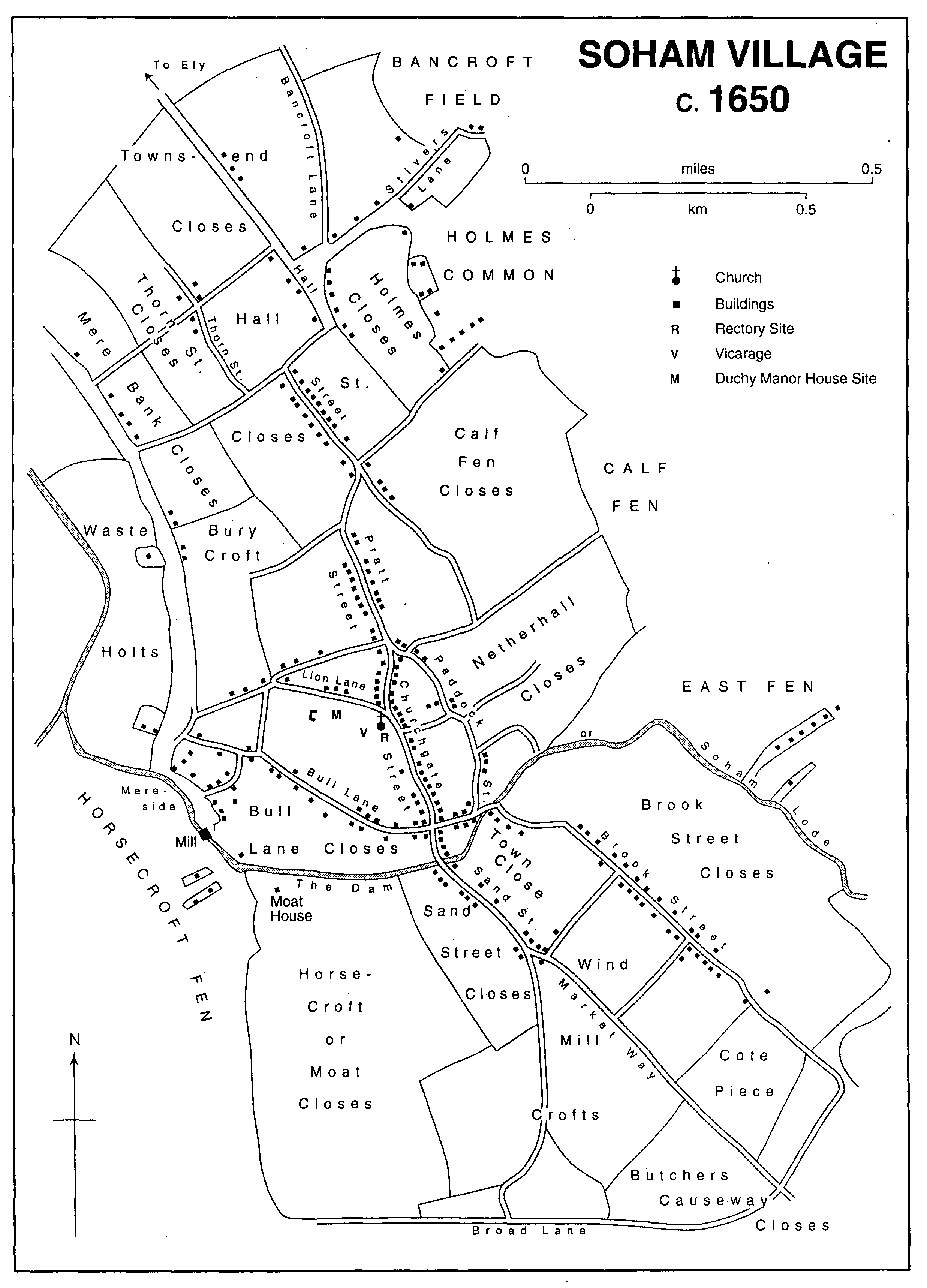
Soham Village c. 1650
Dwellings continued also to be built on the commons east of the village. In 1808 and later the Duchy manor court often forbade occupants of cottages newly built on encroachments on the poor's commons to exercise common rights there or to enlarge their gardens, and several times unsuccessfully ordered the cottages to be demolished. (fn. 76) By 1845 almost fifty cottages stood on intakes along the western and northern sides of Qua fen common, and over forty more on East Fen common, half of them recently built on its northern edge. (fn. 77) In 1975 there were still over fifty houses on East Fen common alone. (fn. 78)
To the north-west, although Barway still had barely a dozen houses, intermediate settlements had long been established off the road beside the Mere: c. 12 stood on appropriated common waste at Broad Piece. Further on, around the triangular Cotes Green recorded in the 1650s, where the ways to Ely and Barway divided, (fn. 79) there were others by the late 1760s at Soham Cotes, then so named. (fn. 80) By 1845 a dozen dwellings stood there, including eight in line west of the road.
Several farmhouses, some with dependent labourers' cottages nearby, had also by the 1840s been erected on various holdings out in the fen, including some substantial ones, of grey brick, often slated, for the larger farms on such estates as the Dobedes' 1,880 a. (fn. 81) Smallholders and squatters on the fen tended to build their houses to a traditional design with a narrow twostoreyed timber-framed front block and an outshot at the rear; (fn. 82) a few survived in the 1990s, some leaning over, along the main fen droveways. Since the uninclosed parish housed many smallholders and cottagers, a high proportion of dwellings, especially in the fen, was owneroccupied in the 1840s, c. 100 out of the 180 reckoned as houses and c. 135 out of 245 cottages. (fn. 83)
Between the 1850s and 1880s 120-30 of Soham's houses and cottages, housing c. 600 people and in 1861 almost 700, thus stood scattered in the fen; among them were c. 35 put up by the 1870s at intervals along Great Fen Drove. At Barway, however, the 12-16 dwellings had only 60-80 residents. Of the encroachments on commons the Cotes then had only ten dwellings with 40-50 inhabitants, but Broad Piece had 25-30, occupied by 130-50 people, while on the Shade common just north of Townsend there were usually 20 dwellings. The village itself had c. 1,750 inhabitants in the 1850s and again in 1881, but in 1871 almost 2,000, nearly half the parish's total population. Within it 215-35 dwellings stood along the main street and another 180-210 on the lanes leading off it to east and west. To the west 140-50 more, with 600 or more inhabitants, stretched along the fen edge from groups of cottages at Mill and Hunts Corners northward along Mereside, where c. 30 more dwellings were added in the 1870s. New building had also probably by then occurred along the newly renamed Station Road leading westward from the main street. East of the main street there was some decline in density between 1851 and 1881. Brook Street shrank from 37 to 25 dwellings, while the cottages, occupied by numerous labourers' families, straggling along the edges of East and Qua Fen commons, were reduced from the 198 into which c. 900 people were crowded in 1851 to 163, housing c. 650 people, by 1881. (fn. 84) Emigration or dereliction left many dwellings empty, 63 in 1851, 45-55 from the 1860s to the 1898s, and 69 even in 1901. (fn. 85)
Relatively few houses survive in the village from before 1800. The few timber-framed 16thcentury ones include one on the Causeway leading to Brook Street: it originally had a hall and cross-passage, earlier than the parlour block but converted to give two storeys in the 17th century, when a new rear service wing was added. West of the High Street four bays survive from a row of timber-framed, gabled, 16th-century houses, possibly built for use as shops; they were later cased, and their jetties underbuilt, in brick. (fn. 86) East of Hall Street stands a sequence of substantial brick-fronted, late 18th- and early 19th-century houses, including Sundial House, dated 1781; some have flint endwalls under tall gables. (fn. 87) West of the modern High Street stands an early 18th-century greybrick house, called in the 20th century the Manor House. It is doublepile and two-storeyed, with an attic in the hipped tiled roof. The five-bayed façade has a parapet and a pedimented Doric doorway. Inside, it retains much original joinery, including a staircase with turned balusters, fielded panelling, and carved fireplace surrounds. (fn. 88) South of the bridge Sand Street, where several professional men dwelt in the mid 19th century, (fn. 89) also retains some architecturally ambitious brick houses from that period, among them the three-bayed Soham Hall with a classic pillared porch. A once thatched cottage orné has a loggia on wooden posts and Gothick windows. (fn. 90) Many older houses were lost to the fires which often ravaged Soham's streets in the mid 19th century. (fn. 91) One on Hall Street in 1846 destroyed 13 houses, four workshops, and a public house, (fn. 92) another fire in 1847 five houses on Pratt Street. (fn. 93) Subsequent rebuilding meant that the visible elements along the older village streets were mostly 19th-century greybrick houses with slated roofs standing close together, and in the very centre continuously: (fn. 94) the larger ones, which are interspersed with smaller cottages, have standard three-bayed fronts, and doorways often with belated classical details. Further out to north and south wealthier villagers erected substantial houses in brick, sometimes stonedressed, in styles verging towards the Italianate.
The 1,118 households reported in the parish in 1911 (fn. 95) were accommodated in some 275 houses and 700 cottages. Of c. 180 houses and 275 cottages in the village, 139 houses and 106 cottages stood on the main long village street from Townsend towards Brook Street and the Fordham road, while another 38 and 169 respectively were on the side roads and lanes off it, chiefly to the west around Clay Street and Station Road. Further west there were 52 dwellings at Mill Corner, where brick terraces of cottages survived in the 1990s, and 70 cottages along Mereside. To the north-west there were 16 dwellings at Broad Piece and 25 at the Cotes. Around the edges of the eastern commons straggled 167 others, also mostly cottages, and 40 more had encroached on the Shade, another common, off the Ely road. Barway hamlet had only eleven dwellings and Henny nine, but c. 80 more, two thirds cottages, were scattered elsewhere in the fens. Many cottages were still owner-occupied, but c. 270 belonged to landlords letting eight or more each; one owned 58 cottages. (fn. 96)
By 1900 Soham village had attained the shape which it retained into the mid 20th century: the long central spine, the main street and its side streets, was flanked by lines of poorer houses on the mere and common edges, with some infilling but without much growth. Only 140 houses were added in the 1920s in the whole parish and 200 between 1931 and 1951. (fn. 97) In 1976 half the 173 houses standing in the village centre dated from before 1914. (fn. 98) From 1945 the council built extensively in the parish, where it had had 583 council houses by 1975. (fn. 99) Its earliest large development was some way south of the village. Downfield, a large estate (fn. 100) which had 700 inhabitants by 1976, (fn. 101) was steadily built on former farmland along two new roads, which ran south from the Fordham road. Laid out in the late 1940s, it was completed in the 1990s with several closes at its south end. From the 1950s the council also developed the curved Queensway, including over 70 prefabricated houses, (fn. 102) a little north-east of Pratt Street; similar houses went up on Staples Lane linking the Fordham road to Brook Street. (fn. 103) New building was most rapid between the late 1960s and early 1980s: 230 houses were under construction in 1975. (fn. 104) There was little space left for infilling on the older streets, but between the 1960s and the 1980s building took place at and beyond the eastern ends of lanes running east off the main street; among those thus developed were Brewhouse Lane off Paddock Street by 1970, (fn. 105) Bushel Lane off Hall Street, and in the 1990s Holmes and Bancroft Lanes off Townsend. (fn. 106) All those lanes also had closes built off them. From 1974, too, 33 houses went up off the western end of Clay Street. (fn. 107) In 1975 the area between the Causeway and Brook and Sand Streets was filled in with a council estate of 80-90 houses. (fn. 108) The thickest development came west of the main street: closely packed groups of houses and bungalows, sometimes built at densities of eight to the acre, covered the land north from Station Road as far as a lane that links the north end of Hall Street to Mereside. (fn. 109) In the 1990s more, partly council, housing was laid out north of that lane. (fn. 110)
Other new estates, mainly private, including one of over 100 dwellings called Northfields begun in 1975, were still going up in the 1990s on new roads off each side of Townsend, (fn. 111) from which ribbon building was then also extending along the Ely road. About 1978 c. 80 dwellings, 50 at Northfields, put up by the council in excess of demand, were sold or let to American airmen from airfields in Suffolk. (fn. 112) Other ribbon building, old and new, stretched along the road along the mere edge almost continuously northwestward to Soham Cotes, and also along the Hasse road, which runs across the fen north-east from the village. In the parish as a whole c. 240 new houses were added in the 1950s and c. 200 in the 1970s. By 1981 almost a third of the dwellings were council houses. (fn. 113) Over 600 more houses were built by 1991, when there were altogether 3,027 dwellings, only a fifth of which were still in council ownership and two thirds, compared with a half in 1981, owner-occupied. (fn. 114) By 1992 the council estates had been taken over by the Hereward Housing Association. (fn. 115) From the late 1960s sites for gipsies, though insufficient, were provided on Angle Common south-west of the village. (fn. 116)
The old village centre was made a conservation area c. 1975. (fn. 117) A Soham Society was founded in 1976 to preserve local amenities. (fn. 118) In 1921 a stone war memorial surmounted by the statue of a soldier was erected in Red Lion Square off the high street. (fn. 119)
Communications.
In the 11th century Soham lay at the end of passage by land towards the fens: the only way northward across them to Ely was by boat or in winter by sledging over the ice. (fn. 120) About 1110, after an Exning man had called for a road linking Ely to Bury St. Edmunds (Suff.), a monk of Ely priory constructed on bundles of reeds a causeway including small bridges, connecting Soham with Ely. (fn. 121) In the late 13th century the priory was still held responsible for maintaining it from the 'head', presumably the north end, of Soham village to the 'bishop's delf' on the Ely border, together with the bridges on that section. Soham's manorial lords were expected to repair it further south. (fn. 122) The monks, who leased the Duchy manor in the mid 14th century, continued to repair that causeway with reeds and pay its keeper's wage in the 1360s. (fn. 123) However, from the 1370s to the 1460s, when they no longer had an economic interest involved, there were occasional complaints that they neglected the causeway and the bridges on it. (fn. 124) The dean and chapter of Ely still contributed in the 18th century to the repair of the road north from the village's northern end towards Ely and of those bridges, which included by 1820 the main Delph bridge across the Crooked Drain. Between 1763 and 1874 that road was part of a turnpike running through Ely to Cambridge. (fn. 125) Soham people occasionally protested against tolls being levied on their carts bringing in turf from the fen at the tollgate, close to the north end. (fn. 126)
South-eastwards from the village a road, styled a causeway in the 16th century, ran towards Fordham and Newmarket; part was known from the 1630s to the 1860s as Butchers' causeway. Its southern continuation was by 1650 called Market way. (fn. 127) Other roads south of the village, such as Wicken way, mentioned from c. 1500, running west over Down and Noditch fields, (fn. 128) largely follow their gently curving medieval courses, unaltered by any inclosure. Those to north, east, and west were based on fen droveways; the droveways on the north, laid out from the 1660s, (fn. 129) were relatively straighter.
Soham's connexions northward by navigation along Soham Lode and through the Ouse to King's Lynn (Norf.) were still important in the mid 19th century when they provided a channel for the export of farm produce and the import of coal. By 1804 there was a dock on Soham Lode by the Anchor inn west of the village. (fn. 130) By the 1840s, however, Soham businessmen complained of the greater expense of water in comparison with rail traffic. (fn. 131) John Dobede (III), the wealthiest inhabitant, who c. 1837 had helped start a thrice-weekly coach service from the Crown inn to Cambridge, (fn. 132) from 1846 to the late 1850s occasionally chaired meetings to discuss proposals for a railway connexion to Ely. (fn. 133) Soham, however, had to wait for its railway until the Ely-Newmarket line was built in 1879. A station was then opened close to the Lode, off a square, with a newly established Station Hotel, laid out beyond the junction of Clay Street and Cock Lane, renamed Station Road by 1881. (fn. 134) From 1879 the railway's weighbridge at Newmarket replaced for weighing hay and corn by the cartload the late 18th-century steelyard, recorded from the 1780s, at the modern Fountain inn. That steelyard, supported in a timber-framed, weatherboarded structure on a brick base standing west of the inn, was restored in 1929. It still retained in the late 20th century some of the 18th-century machinery that worked the balance hanging over the roadway. (fn. 135)
The 19th-century station was destroyed in June 1944 when a long train carrying explosives blew up through a fire, killing two of its four crew, ruining other buildings nearby, and damaging c. 760 houses in the village. (fn. 136) The temporary station put up in its place was closed to passengers in 1965-6 and later demolished, although the line remained in use in the 1990s. (fn. 137)
In the late 20th century Soham relied for public transport on occasional buses. A bus service to Ely started by 1925, but the local bus depot closed 1967 × 1975. (fn. 138) Motor traffic had been coming through the village since 1900. (fn. 139) By the 1970s its narrow streets, obstructed with parked cars, were overcharged with more than 7,000 vehicles passing daily, including 1,000 heavy lorries. (fn. 140) A bypass, planned from 1976, was finally built, sweeping across the commons east of the village, in 1980-1. (fn. 141) The disused lode, ill-cleaned especially on its upper course and sometimes causing flooding near the village, had its course near the Brook Dam altered in 1979. (fn. 142)
Inns and alehouses.
Alewives were recorded in the late 14th century, when the Duchy manor court supervised 6-10 of them. (fn. 143) Taverns were recorded c. 1640. (fn. 144) The village's alehouses then included the Bull, certainly an inn in the 1630s, (fn. 145) and the Lion, (fn. 146) which stood in 1656 on the high street near the ends of the lanes named after them, while the Bear was recorded 1628 × 1656 and the George mentioned in 1637. (fn. 147) One public house recorded from the 1610s bearing the sign of the Lion, by 1787 known as the White Lion and renamed 1823 × 1835 the Fountain, occupied a house opposite the churchyard. After its front part was destroyed by fire in 1900, it was mostly rebuilt in red brick with prominent gables, but part of its timber-framed, 16thcentury rear wing survived. (fn. 148) There were several other inns on the high street. The Crown, perhaps open by 1701 and well equipped to take guests in 1816, closed in 1967. (fn. 149) The White Hart, recorded from the 1790s, occupied until its closure c. 1945 a timber-framed 16th-century house, containing an original hall range with a crownpost roof, into which a floor was inserted c. 1600; a rear wing was added c. 1630. The plastered front was remodelled in the 19th century and again after closure when it was converted into two shops. (fn. 150) The Red Lion, mentioned in 1677, (fn. 151) still occupied in the 1990s a thatched house, fivebayed and one-storeyed with dormers, (fn. 152) standing north of the square named after it from the 1850s. (fn. 153) Those four long remained the village's principal inns: auctions were held at them from the late 18th century, and all four were open into the 20th century. Outside the village were the Cherry Tree, opened by 1845, off the Fordham road southwards beyond Mill Croft, and the Tiger beyond North field, opened by 1820 and closed in 1970. (fn. 154) Both were usually run with adjoining farms. (fn. 155)
From the mid 19th century the parish had almost forty public houses and beerhouses; two, including the Crown, styled themselves hotels from the 1880s. Three quarters were in the village. Others stood out in the fen or on the roads towards it. (fn. 156) From the 1880s Soham had a substantial brewery, opened off Paddock Street by the Cutlacks and owned and worked from the 1890s to c. 1925 by their successors, Treadway and Percy, who also sold wine and spirits from a shop on Churchgate Street. Their former brewhouse remained in use, following takeovers by outside breweries, into the 1930s. It still stood, disused, off the east end of Brewhouse Lane in 1997. (fn. 157) In the late 1930s there were still twelve public houses on the village streets and lanes. Among nine others on its outskirts and elsewhere in the parish were two at the Shade, one at the Cotes, and two more in the fen. (fn. 158) By 1976, two having closed since 1967, (fn. 159) only four were open in the village centre with two near the former station. (fn. 160) The few still open in the 1990s included the Bushel and Strike, recorded by 1841, at the south end of Hall Street, occupying an early 18th-century house with pilaster strips. (fn. 161) Of five public houses outside the village in 1976, the largest was the Cherry Tree, rebuilt after a fire in 1946 as a redbrick roadhouse. (fn. 162) By the 1990s an early 19th-century house on Brook Street had been converted to a motel. The village then had several restaurants, including Chinese, Italian, and American Western ones.
Barway had a public house in 1810, (fn. 163) probably that called the Bull, 1860-80, but later only a beershop. (fn. 164) In the late 19th century occasional entertainments there had to be held in barns. (fn. 165) A village hall built for the hamlet c. 1945, with a corrugated iron roof, was in disrepair by 1970 (fn. 166) and disused from the mid 1980s, but still stood in 1996. (fn. 167)
Social activites.
In the 19th century the village inns accommodated Soham's principal friendly societies. One had had 60 members in 1803, 129 by the mid 1810s. (fn. 168) Among its successors was a branch of the Oddfellows, which had over 50 members in the 1840s when it was founded with support from a curate, (fn. 169) and over 120 by 1890. (fn. 170) A lodge of Ancient Shepherds, started in 1845-6, likewise usually met at the Red Lion. (fn. 171) It had normally 60-80 members, over 100 c. 1860. (fn. 172) Both still flourished in the 1930s, along with three minor societies, two of which were attached to lesser federations of friendly societies and linked with other public houses. A third, purely local one, long attached to the Primitive Methodist chapel, was replaced c. 1905 by a slate club at the Station Hotel. (fn. 173)
A pleasure fair held with the Whitsun horse fair still attracted swings and roundabouts in the 1860s, but was declining by the 1880s. (fn. 174) Soham's chief 19th-century holiday was the village feast, by the 1750s starting on the Monday after Midsummer, the date selected for one of the fairs granted in 1679 to Sir Thomas Chicheley. (fn. 175) Usually held by the 1840s from Monday to Wednesday, the feast continued to flourish, even though fewer travelling showmen appeared in the 1870s and 1880s, in the 1890s. (fn. 176) From the 1850s it included a cricket match. (fn. 177) From c. 1850 to the early 1880s the landlord of the Crown brought down singers and acrobats from London to perform on his bowling green, also displaying fireworks. (fn. 178) A local amateur brass band, founded by 1853, gave outdoor gala concerts, still attended by up to 1,500 people in the 1880s. (fn. 179) An outdoor 'gipsy tea' on the Thursday after, which Soham temperance supporters started c. 1855 in protest at excesses of conviviality during the feast, was from the late 1860s co-opted as a customary part of it. (fn. 180) From 1860 to c. 1875 the Anglican clergy sponsored, during their July Sunday-school festivities, flower and vegetable shows for cottagers, (fn. 181) revived for allotment-holders from 1888 by a Horticultural Society. (fn. 182) From the late 1890s to the 1920s the feast was gradually overshadowed by a parade, started by the vicar c. 1898, held on the Sunday before in support of Addenbrooke's Hospital. (fn. 183) From 1953 a carnival was held yearly at Whitsun, organized by the Soham Benevolent Association to raise funds for local causes: in the 1960s, at its peak it attracted c. 15,000 visitors. Its parade of floats (fn. 184) was replaced from 1973 with a show of up to 100 heavy horses, grazed on Soham's commons. (fn. 185) The carnival was supplemented from 1976 by an autumn 'pumpkin fair', also continuing in the 1990s. (fn. 186)
In the mid 19th century Soham was large enough to attract occasional visits from travelling circuses and menageries (fn. 187) and acting companies. (fn. 188) In 1862 a rope-walking performance by Blondin, initially promoted by a local publican, drew 3,000 spectators. (fn. 189) The village itself held concerts, occasionally from the 1820s, (fn. 190) frequently from the 1850s, when the Court House or Town Hall provided a venue for music, lectures, and other shows. (fn. 191) A local Rifle Corps established in 1861 as part of the county volunteers provided itself with a fife and drum band well before it received any uniforms or weapons. (fn. 192) A musical society formed in 1884 gave two or three concerts each winter in the late 1880s, (fn. 193) while a dramatic society started by 1892 perhaps survived with intermissions into the 1950s. From 1960 plays were produced locally by the village college Players. (fn. 194) Films were shown at Soham from 1908. By 1912 Taylor's, its coachmakers, fitted up a workshop with seating to show them. In 1913 they put up a purpose-built cinema, a plain red brick shedlike building, on Clay Street. In business until the 1930s as the Electric cinema, (fn. 195) thereafter renamed the Regal, it ceased showing films in 1950. A rival cinema, the Regent, open from 1939 in a bulkier building south of Red Lion Square, was closed in 1969. Briefly used for youth club discos, that building was converted to a warehouse c. 1975, (fn. 196) and survived in the 1990s.
The 19th century saw several attempts to start a village institute and reading room. The dissenting schoolmaster, David Gunton, supported a Literary and Scientific Institute which opened in 1842 with 40 members. (fn. 197) In 1850 some village youths started a Mutual Improvement Society. (fn. 198) In 1856 a local printer and bookseller started a subscription reading room, and another was open at the boys' school c. 1868-70. (fn. 199) There was a 'young men's institute' c. 1872-5. (fn. 200) In 1901 another institute with a reading room was opened, using rooms in the basement of the People's Hall on Station Street, (fn. 201) one of the meeting places that Soham owed to late 19thcentury political divisions. A Conservative association supposedly for working men was formed in 1886-7, when it opened on White Hart Lane a club hall with a stage and a billiard room. (fn. 202) The rival People's Hall was opened later in 1887, apparently by Soham's Liberals who had their own clubhouse on Churchgate Street; it served as the Literary and Social Institute from 1901 to the 1930s, (fn. 203) when both party clubs still flourished. (fn. 204) In the 1970s the village still had active Liberal and Labour party branches. (fn. 205) From 1919 the Soham Comrades Club, initially of former soldiers, took over the former Court House by the market place as their clubhouse. (fn. 206) Still active in the late 20th century, that club had 500 members in 1988, when it enlarged the building. (fn. 207) A Women's Institute, started only in 1944, was in 1961 with its 200 members the largest in the county. (fn. 208) In the late 20th century Soham had numerous social, sports, and other clubs, among them ones for cricket, bowls, and tennis, (fn. 209) also intermittently youth clubs. (fn. 210) Two early 20th-century bands, one, the Excelsior, encouraged by a curate, the other from the Salvation Army, were united in 1921 as the Soham Comrades band, (fn. 211) still playing successfully in the 1990s. (fn. 212)
A cricket club, which played from the 1830s, was reorganized at intervals in the 19th century (fn. 213) and again, when it had a ground, in 1901, along with a football club, whose formation had been discussed from 1889. (fn. 214) In the 1990s Soham United football club still used a ground on Qua Fen common, long rented from the parish. (fn. 215) Soham Town Rangers, formed in 1947 by merging two earlier clubs, acquired in 1949 an existing ground south of Julius Martin Lane, where its clubhouse was rebuilt in 1989. (fn. 216) In 1929 the parish council acquired for a recreation ground, still in use in the 1990s, 7 a. of the grounds of Soham Place west of the church; they included the former 5 1/2-a. Camping close, probably used for games before 1800. The ground floor of the Place, also eventually acquired, all that survived demolition, became a public meeting space. (fn. 217) A sports hall with extensive indoor facilities, adjoining part of Soham village college, planned from 1982 by the Soham and District Sports Association, was opened in 1994. (fn. 218) In the early 20th century villagers had swum in an open-air pool fed from the lode. (fn. 219) An outdoor pool supported in the 1970s by the parish council (fn. 220) was replaced by a new one opened in 1995. (fn. 221) A county library long cramped in a former shop on Churchgate Street was moved in 1994 to the remodelled former county junior school off Clay Street. (fn. 222)