A History of the County of Cambridge and the Isle of Ely: Volume 9, Chesterton, Northstowe, and Papworth Hundreds. Originally published by Victoria County History, London, 1989.
This free content was digitised by double rekeying. All rights reserved.
'Waterbeach: Introduction', in A History of the County of Cambridge and the Isle of Ely: Volume 9, Chesterton, Northstowe, and Papworth Hundreds, ed. A P M Wright, C P Lewis (London, 1989), British History Online https://www.british-history.ac.uk/vch/cambs/vol9/pp237-243 [accessed 30 April 2025].
'Waterbeach: Introduction', in A History of the County of Cambridge and the Isle of Ely: Volume 9, Chesterton, Northstowe, and Papworth Hundreds. Edited by A P M Wright, C P Lewis (London, 1989), British History Online, accessed April 30, 2025, https://www.british-history.ac.uk/vch/cambs/vol9/pp237-243.
"Waterbeach: Introduction". A History of the County of Cambridge and the Isle of Ely: Volume 9, Chesterton, Northstowe, and Papworth Hundreds. Ed. A P M Wright, C P Lewis (London, 1989), British History Online. Web. 30 April 2025. https://www.british-history.ac.uk/vch/cambs/vol9/pp237-243.
WATERBEACH
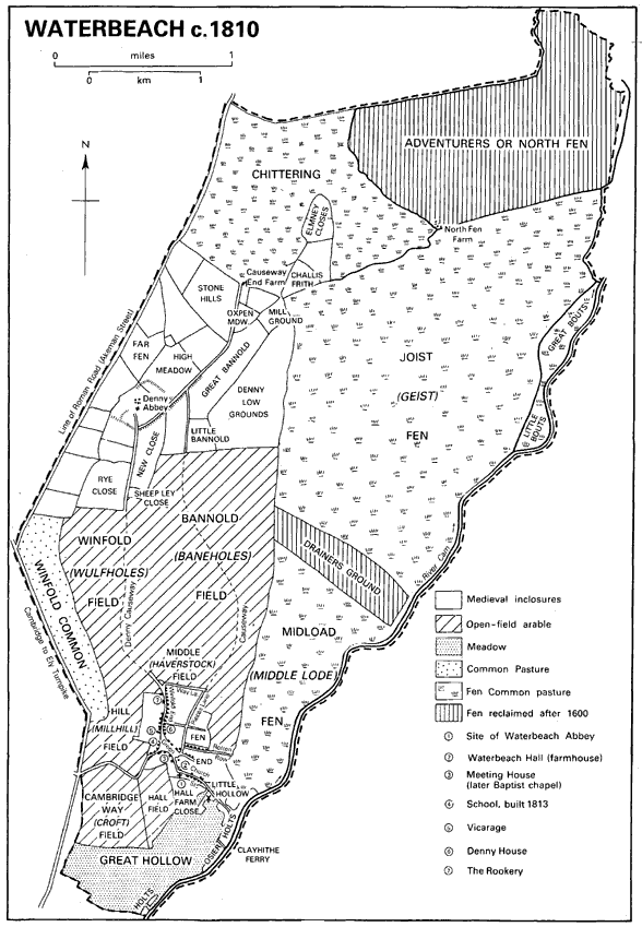
THE extensive parish of Waterbeach, (fn. 1) in which the village stands c. 8 km. (5 miles) north-northeast of Cambridge, stretches for almost 8 km. along the west bank of the river Cam. (fn. 2) Its original name of Beach, perhaps from a ridge, was from the 12th century qualified to distinguish it from its western neighbour Landbeach. (fn. 3) Waterbeach covers 2,327 ha. (c. 5,750 a.). (fn. 4) The boundary follows on the southwest old open field divisions and the Car Dyke or Old Tillage, the 2nd-century navigation channel, which, starting south-east of the village, linked the Cam with the arm of the Ouse later called the Old West river. (fn. 5) At Goose Hall the boundary turns north-east to run along the late Roman road, called Akeman Street, before bending again to follow a lode towards the Ouse. (fn. 6) The northern boundary, partly following a drainage ditch, was probably laid down when fenland previously intercommonable by Waterbeach and Stretham was formally divided in 1293. (fn. 7)
The soil of the parish lies mainly upon gault. The Lower Greensand beneath it is exposed at the north-west corner, the gault itself only along the spine of the parish, being covered to east and west by river gravels. Alluvial deposits lie beside the river, while the northern third of the parish consists mostly of peat. (fn. 8) The land is virtually level, lying entirely below 10 m. (30 ft.). The slightly higher soils along the western side were the first to be brought under cultivation, those at the south end being occupied from the Middle Ages by open fields farmed under a triennial rotation until inclosure in 1812. Further north on that side were extensive pastures held in severalty, re-established from the 12th century in an area that had probably been once already reclaimed from fenland in Roman times. Much farmland just north of the village was taken c. 1940 for the runways and buildings of an R.A.F. airfield. (fn. 9)
The eastern half of the parish remained fen pasture until after 1800. In 1636 there were reckoned to be c. 3,375 a. of common fen and wet ground there, (fn. 10) of which 750 a. were allotted to the Adventurers of the Bedford Level in 1637. (fn. 11) Most of that land, the later North Fen, 638 a. in the far north of the parish, was for a time brought under cultivation, (fn. 12) but in 1729, after seven years of flooding, an Act was sought for draining the Waterbeach Level. (fn. 13) That Act, passed in 1740, set up a commission, (fn. 14) which under Acts of 1766, 1797, and 1813 might levy local rates increased from 1s. per acre in 1740 to 5s. in 1813, to support borrowing that had reached £200 by 1797. The 1766 Act met with some opposition at Waterbeach, over 70 commoners dissenting. (fn. 15) Under those Acts the Commissioners' Drain was made, probably after the inclosure of 1814; (fn. 16) running north-east from near Bottisham Lock, it became the principal artery of Midload and Joist Fens in the east. Bannold Ditch, which meanders along a course to the west, largely follows the eastern boundary of the former open fields, and probably dates from an earlier period. The commissioners put up two windmills, one in Stretham, to help carry the water off, soon after 1740, a third, Upper Mill, only after 1766. By the 1790s the mills and banks were in decay. In the early 1830s the windmills were replaced with steam engines. (fn. 17) The network of lesser channels on a rectangular pattern that drains the eastern and northern edges of Waterbeach was resumably also laid out at inclosure, for they largely follow the boundaries of the allotments then made. (fn. 18)
Waterbeach c. 1810
The parish had no ancient woodland, but some elm groves, one of 18 a. called Bannold wood, were recorded in the early 17th century, when the lessees of the manor were felling them for their own profit. (fn. 19)
The north-eastern marshes were settled during the Roman organization of farming in the fenlands. Earthworks at Denny Lodge Farm and near Causeway End Farm in Chittering Fen indicate dwellings and inclosed fields, occupied from the early 2nd century to the early 4th. (fn. 20) Other earthworks around Denny Abbey also date from the Roman period. (fn. 21) When monks arrived at Denny ('Danes' Isle') c. 1150, they found the presumably empty higher ground there and at the neighbouring Elmney isolated amid marshes. (fn. 22) By then an English village had long been settled in the south: early AngloSaxon pottery has been found near the Car Dyke just west of the modern village. (fn. 23) That village is distinguished from Landbeach by its render of 1,450 eels as the 'Bech' of Domesday, when it contained 47 peasants. (fn. 24)
The population had grown greatly by 1279 when c. 180 tenants and 68 messuages and tofts were recorded. (fn. 25) About 1325 c. 160 tenants owed ploughing boons on the largest manor, (fn. 26) and 55 people paid the fifteenth in 1327. (fn. 27) In 1377 there were 205 adults paying the poll tax. (fn. 28) Although in 1524 only 31 people paid tax, (fn. 29) 70 households were reported in 1563. (fn. 30) In the 1660s there were c. 120 inhabited dwellings. (fn. 31) In 1728, however, only 74 families comprising c. 315 people were recorded. (fn. 32) By 1801 c. 129 households contained 553 people. Thereafter the population rose steadily, by between 130 and 200 in each decade, to reach c. 1,065 in 1831 and 1,270 in 1841. (fn. 33) Growth then slowed briefly, as overpopulation was partially relieved by emigration: five families numbering 40 persons left for America in 1849, (fn. 34) 80 people for Australia in 1850, (fn. 35) and emigration continued into the 1870s. (fn. 36) The village was also ravaged by typhoid in 1849 and by cholera in 1854. (fn. 37) The population stood at c. 1,440 in the 1850s, before increasing again to a peak of 1,619 in 1871. Then it declined steadily by 110 in each decade to 1,277 in 1901, but recovered to c. 1,430 in 1911 and 1931. Rapid growth accompanied the establishment of the airfield: of 2,630 inhabitants in 1951 1,880 belonged to private families, of whom many worked for the R.A.F. Military personnel numbered only some 200 in the 1950s and 1960s, but the civil population rose to 2,351 by 1961, c. 2,800 in 1971, and 3,551 out of c. 3,800 permanent residents in 1981. (fn. 38)
The village stands within the southern tip of the parish, where the gault is exposed, close to the river, but almost 1 km. east of the Roman road. (fn. 39) Before 19th- and 20th-century changes its houses mostly stretched along a main street running north-south, whose southern half widened into a green. The green had already suffered much encroachment from housing on its south and west sides by the 17th century. (fn. 40) Further losses in the mid 19th, partly for public purposes, had by 1901 reduced it to an hourglass shape. To the north the long crofts bordering the narrower section of the street perhaps represent strips taken in from open-field land in the Middle Ages: the village was still growing c. 1345, when Waterbeach abbey built six cottages. (fn. 41) Some decaying messuages were noted in the 1350s. (fn. 42) The back lane east of the green, called Fen Road after 1900 but in 1814 Pieces Lane, (fn. 43) was possibly so named from former open-field strips. Its original name was later transferred to the lane running east to the fen, called in 1814, as c. 1613, Way Lane. (fn. 44) Other lanes also ran east from the street by 1350: to the north was New Row, so named by 1364, where the small crofts on its north side were occupied by 'chambers', (fn. 45) perhaps single-room dwellings forming a terrace of housing for the poor. By 1546 they had so decayed that it was called Rotten Row, (fn. 46) a name retained until after 1800. (fn. 47) From the south-east corner of the green a road ran past the church and the site of the late 13th-century Waterbeach abbey. It was prolonged eastward and southward by a causeway, in the 16th century maintained under court leet orders (fn. 48) and through legacies. (fn. 49) It led to the ferry across the Cam at Clayhithe, settlement at which was mentioned in the 1330s. (fn. 50) There was a newly built house at Clayhithe in 1375, (fn. 51) and several residents were recorded in the 1420s and 1430s. (fn. 52)
Otherwise, save for the three farmsteads established at Denny Abbey, at Causeway End Farm, recorded by 1740, (fn. 53) on the old Elmney islet, and at North Farm (fn. 54) from which the Adventurers' land in the far north was cultivated, there was no settlement away from the village until inclosure in 1814. By the mid 17th century the village crofts were filled with the small dwellings of the numerous 'poor and mean people', who could support what outsiders thought 'an easy, idle life' from the resources of the fenland by fishing, fowling, and feeding cattle. (fn. 55) Of c. 85 houses and 10 cottages recorded in 1617 c. 26 had only one or two bays, and 50 had three, while only 13 were certainly larger. (fn. 56) Of 134 houses taxed in 1674 there were 111 with one or two hearths, and only 6 with more than four. (fn. 57)
The number of separate dwellings perhaps declined later: 106 families were crowded into 86 houses in 1794, (fn. 58) and 138 occupied 96 dwellings in 1801. (fn. 59) The total of inhabited dwellings increased from 229 in 1831 to 309 by 1851 and 346 in 1871. (fn. 60) Of those in or near the village, (fn. 61) numbering about 220 in 1841, 255 by 1861, and 275 in 1871, the number around the green, then styled High Street, increased from c. 72 in 1841 to c. 85 in the 1860s. Those along Church Street leading south-east numbered c. 30 before 1850, c. 40 later; humbler cottages were put up further east along Station Road, so named by 1871. The Cambridge road linking the village to the turnpike was also gradually built up, and Mill End north of that road had c. 25 houses by the 1860s. The street leading north from the green, called c. 1840 Winfold End, later Denny End, had only 14 dwellings in 1841, but 27 by 1851, and 35 by the 1860s, while labourers' cottages, numbering c. 70 in 1841, 85-95 after 1860, crowded the lanes east of the green, collectively called by the 1850s Fen End.
By the late 19th century not many of the traditional, timber-framed and reed-thatched houses were left: in the 1950s fewer than 10 survived from the 17th and 18th centuries. (fn. 62) Many were destroyed in the numerous fires, ascribed to accident or arson, which swept the village from the 1830s to the 1870s. (fn. 63) Moreover after inclosure some of the more prosperous smallholders rebuilt their dwellings in grey brick on a standard square plan with a three-bay front and central doorway. Several of that type survived in the 1980s along the main street. There was also much new building on the smaller farms created after inclosure in the former fen, where the number of houses rose from c. 40 in 1841, including 9 farmhouses, to 65-70 in the 1860s, among them 24 farmhouses, the rest mostly labourers' cottages. (fn. 64) Those farmhouses were mostly strung out along the straight new roads laid out through the fen after 1814. (fn. 65)
In the late 19th century the number of inhabited dwellings shrank: 21 out of 340 houses were empty in 1881 and 36 by 1891. (fn. 66) In 1910 the village contained c. 96 houses and 138 cottages, of which 8 houses and 43 cottages stood at Fen End, and 30 houses and 50 cottages in the fen. (fn. 67) After 1921 the total number of dwellings in the parish grew from 355 to 399 by 1931, and to 584 by 1951. The building of 20 a year on average over the next 20 years and of c. 330 in the 1970s raised the total to 1,283 by 1981. (fn. 68) Apart from the erection of married quarters at the airfield, for which a new estate of almost 80 houses was being planned in the 1970s, (fn. 69) growth came partly from infilling along the old streets and lanes, as at Denny End, and partly from small new developments just off them. (fn. 70) Large estates were laid out east and west of the main street in the 1960s and 1970s. (fn. 71) Almost 60 new houses were put up between 1945 and 1967, when a council estate of 120 was planned. (fn. 72) Some 60 a. northeast of the old village were designated for new housing in 1971. (fn. 73) In 1972 a Village Society was formed to oppose growth that would impair the village's character. (fn. 74) Almost 120 more houses, partly at Denny End, were proposed c. 1975, when c. 200 were under construction. Of c. 1,000 more inhabitants expected between 1978 and 1981, 300 had settled by 1979. (fn. 75) Moreover, caravan parks were set up, one at Denny End, (fn. 76) which had 50 places by 1962, (fn. 77) another at Bottisham Lock. (fn. 78)
Before 1800 the main site of habitation away from the village was at Denny, c. 2 km. to the north, and formerly approached by a low causeway, where there are substantial remains of monastic buildings. Founded by Benedictine monks in the mid 12th century, they were occupied from the 1170s to 1308 by the Knights Templar, and from the 1340s to the Dissolution by Franciscan nuns installed by Mary, countess of Pembroke. The intended plan of the Benedictine church can be deduced from its surviving central portion and from traces of walls found during excavations. (fn. 79) The church had a chancel of three bays, possibly square-ended. The tower over the crossing was only partly built, but there are north and south transepts. The aisled nave was to have been of four bays, but only part of the first had risen above the foundations when the monks left. The design of that part, with its massive piers supporting plainly chamfered arches with scalloped capitals and its one-light windows, resembles contemporary work at Ely. The gabled window in the north transept and the presence of a night stair at the south-west angle of the south transept show that the claustral buildings were planned south of the church, although temporary living accommodation was put up north of the nave.
It was that accommodation that the Templars took over and later rebuilt and extended. Since they used Denny mainly to house sick or aged brethren, their domestic buildings did not follow any conventional monastic plan. In the late 12th century they completed the nave to a curtailed design of two bays, using more elaborate waterleaf capitals, with only a south aisle, the west doorway having three orders with chevron mouldings. In the mid 13th century they erected against the south-west corner of the shortened church, in an area formerly a burial ground, a two-storeyed stone building, possibly to house a chaplain. North of the nave frequently altered east and west ranges delimited a small courtyard with a well. The range to the north, probably two-storeyed, had a pillared undercroft. In 1308 living quarters included a hall and a chamber with beds for 11 Templars and probably 3 corrodians. (fn. 80) By the 1320s, when a stable adjoined the 'capud ecclesie', there were an old hall, a lord's solar, and a new chamber, all probably thatched: a great wind unroofed the solar c. 1325. (fn. 81)
The countess of Pembroke and the nuns made many alterations. The chancel was demolished and replaced with a spacious aisled chapel almost thrice the length of its predecessor, and as wide as the Benedictine crossing and transepts combined. The east wall of the transept became the west wall of the new choir, of which only the western responds survive above ground. The rest of the Norman church was remodelled, the nave arcade being blocked and new windows inserted. A first floor was put into the nave and crossing, to provide a lodging, perhaps initially for the countess: a first-floor window looked from it into the choir. To provide a hall the south aisle was taken down and a wider range linked the Templars' south-west building to the south transept. A new cloister was made north of the new choir, and probably separated from its north wall by an open court. North of the cloister was the six-bayed refectory, surviving as a barn, in whose windows Decorated tracery survived c. 1730. Within it the lines of the nuns' seating along the sides were still visible in 1987. A small doorway leads from the dais end into the east range of the cloister, where the abbess perhaps lodged.
Following the Dissolution the 14th-century choir was demolished, and the lodgings in and around the older church were converted for a farmhouse. Cottage dwellings occupied part of the former Templar north courtyard between 1550 and 1650. In 1630, when the abbey was 'an ancient decayed house' with its tower 'yet standing', it was shared by Anne Knight with four other families. (fn. 82) The Knights had 10 hearths used by two households in the 1660s. (fn. 83) The farmhouse was reconstructed c. 1700. Its living rooms occupied the range, south of the nave, whose four-bay south front was refaced in red brick, while the north transept became the brewhouse and the south the kitchen, (fn. 84) a massive brick chimney being built into its south wall. New windows were also pierced through the east wall. Much woodwork of that period survived into the 1950s. About 1773 James Essex did much work for Peter Standley, apparently lowering the roofline of the transeptal cross wing and removing any surviving portion of the probable dormitory north of the north transept, (fn. 85) into which the nuns had inserted their night stair. The abbey continued to be used as a farmhouse into the 1930s, (fn. 86) but in 1952 Pembroke College transferred it to the Ministry of Works. (fn. 87) Over the next 35 years the post-medieval insertions were cleared away to reveal the structure of the monastic buildings.
In the 18th century a new road, running along the Landbeach boundary and the Car Dyke, superseded the southern section of the former Roman road as Waterbeach's main land link with the outside world. The new route was laid out under the Cambridge-Ely Turnpike Act of 1763, (fn. 88) and remained a turnpike until 1874. (fn. 89) From 1814 it was linked to Denny End in the village by Winfold Lane. The older Cambridge road, following a dog-legged track along former field paths from the green's south-west corner (fn. 90) was replaced c. 1980 by a new road further south. (fn. 91) Other straight roads were made across the fens c. 1814: the longest was Bannold Drove, while Long Drove followed the Commissioners' Drain further east. The Clayhithe ferry road followed the winding course of the medieval causeway to the ferry (fn. 92) that had belonged to the manor in the Middle Ages. By the 1340s the ferry with the ferryman's house was regularly leased by Denny abbey, the lessee transporting the abbey's officers free of charge. (fn. 93) It remained with the manorial estate until that was split up and sold in 1855-6, (fn. 94) and continued in use until the early 1870s. (fn. 95) In 1870 a company was formed to replace the ferry with an iron bridge nearby, to be maintained out of tolls, (fn. 96) which was opened in 1875. (fn. 97)
Waterborne communications were important into the late 19th century. (fn. 98) A lode led to a small dock south-east of the church. (fn. 99) In 1814 a public wharf near the modern Bottisham Lock was set out for use by local landowners. (fn. 100) By the 18th century the flood banks along the river were much used by horses hauling barges: from 1797 the Waterbeach Level commissioners could levy tolls on those using the bank north of the Brewhouse in Midload Fen; a tollhouse was set up there. (fn. 101) Near Bottisham Lock, reconstructed by 1842, (fn. 102) the Conservators of the River Cam had a sluice keeper's cottage, in use until after 1871. (fn. 103) In the 1870s many people travelled by steamboat to Clayhithe on the August Bank Holiday. (fn. 104) Others went by rail: the Great Eastern Railway main line between Cambridge and Norwich via Ely, passing through the parish close to the river, was opened in 1845, (fn. 105) and a station had been established at Waterbeach by 1851. (fn. 106) Up to six people were employed there in the mid 19th century. (fn. 107) The station, though unstaffed, was still open for occasional passenger traffic in 1986, but the station master's house and the goods yard were closed and sold c. 1966. (fn. 108) The railway supplied custom and fuel for the Waterbeach gas works, run by a company started in 1866. (fn. 109) When its owner, insulted with a skimmington in 1895, cut off the village gas supply, he lost the railway contract and the works closed. (fn. 110) The building, on an encroachment on the south-west corner of the green, still stood in 1986. (fn. 111) A new gas supply from the mains at Lode was sought in 1975, (fn. 112) and gas arrived c. 1985. (fn. 113)
The village had in 1686 one inn with five beds (fn. 114) and by the late 18th century numerous inns and public houses. By 1850 there were more than 10 in or near it. (fn. 115) Among them were the Rose and Crown, where the manor court was held in the 1750s, (fn. 116) and which closed in the 1860s, and the Sun, licensed by 1765, a coaching halt, (fn. 117) where the local branch of the Ancient Shepherds, started c. 1840, usually met by the 1850s. (fn. 118) The Sun and the White Horse, open by 1797, (fn. 119) at the south-east corner of the green, were still open in 1986. Other public houses included one near the station by 1861, closed after 1937, and four at Denny End, of which one survived in 1986 as the Brewery Tap. After 1814 four or five public houses were started in the newly inclosed feris. One, the Dog and Duck, newly built in 1834, (fn. 120) was a farmhouse from 1865. Of two put up by 1850 in Chittering Fen near the turnpike the Plough and Horses closed c. 1900, but the Travellers Rest was still open in 1986. In the 19th century three or four others catered for traffic along the river. The Jolly Anglers and Jolly Waterman, the latter newly built in 1836, (fn. 121) had both closed by 1910, but the Green Man at Bottisham Lock probably survived c. 1930. (fn. 122) At Clayhithe ferry the House of Lords, enlarged by the bridge company in 1875, (fn. 123) was known from the 1880s as the Clayhithe Bridge inn and by 1916 was styled a hotel. Much extended, it was still open in 1986, when it adjoined the boathouses and moorings of the Cam sailing and motor boat clubs. Those clubs also used a privately owned yacht basin at Bottisham Lock, where a new and larger one was excavated in 1975. (fn. 124)
May Day customs and village sports on the green, still kept up in the 1790s, had been long disused by 1820, (fn. 125) although unemployed labourers were still fiddling and Morris dancing on Plough Monday in 1854. (fn. 126) The village Feast was held on the second Monday in July until 1779, when, to prevent its interfering with the harvest, it was moved to the last Monday in May. (fn. 127) Until the 1880s it lasted three days: stalls, swings, and shows were put up on the green, and it was often well attended, some 80 visitors coming on one day in 1831, though it became less rowdy after 1860. (fn. 128) In the early 1880s there was a 'dancing booth', allegedly haunted by prostitutes from Cambridge, which the vicar strove with intermittent success to have closed. (fn. 129) By the 1860s two shows for flowers and vegetables were held annually in July and September by the Waterbeach Horticultural Society; reorganized from 1870 to cover four neighbouring villages. (fn. 130) In the 1880s those shows and their associated sports attracted many visitors from Cambridge. By 1894 they had been moved to the August Bank Holiday. (fn. 131) A main feature of the Feast by 1893 and until 1939 was the procession, led by a brass band, of Waterbeach's two friendly societies, the Foresters and Ancient Shepherds, to the Baptist chapel, in aid of Addenbrooke's hospital. The Feast lapsed during the Second World War, although a few travelling showmen still held a fair on the green at the traditional date into the early 1960s. When in 1971 a new headmaster inspired its revival, (fn. 132) a procession of 20 or more floats became its principal feature. (fn. 133) Moved to mid June in the 1980s, it had drawn attendances of up to 5,000 in the late 1970s. (fn. 134) emph>From 1981 it was enlivened by a marching brass band started in 1978, one of two or three active by 1986. (fn. 135) emph>
At a reading room started in 1854, (fn. 136) the vicar, W. K. Clay, and the Baptist minister gave lectures, some on parish history. (fn. 137) The vicar founded another reading society in 1874. (fn. 138) Village cricket matches were recorded from the 1850s, (fn. 139) and a cricket club was established in 1889. (fn. 140) From the 1950s the recreation ground owned by the parish council provided pitches for cricket, football, tennis, and bowls clubs. (fn. 141) A village drama group started in 1978 used the old school as its headquarters from 1979. (fn. 142) Waterbeach had no village hall in the 1980s: (fn. 143) the new school served as a village library and for meetings and other social activities. (fn. 144) By 1980 a community association grouped the various clubs and voluntary bodies. (fn. 145)
In 1939 almost 700 a. north-west of the village were requisitioned for an airfield. Six hangars were being built in 1940, and a triangle of hard runways was completed early in 1941. Waterbeach airfield, which in December 1944 housed c. 2,600 persons, was used successively for bombers (1941-2, 1943-4), for training (1942-3), by Transport Command (until 1950), and for fighter squadrons (until 1962). (fn. 146) In 1963 it was transferred to the R.A.F. Construction Branch (fn. 147) and in 1966 as Waterbeach barracks to the Royal Engineers (39 Regiment), (fn. 148) primarily concerned with work such as airfield building. (fn. 149) The runways were disused from the 1960s, except for use by a parascending club in the 1980s. (fn. 150) Many service quarters were put up in the 1970s. (fn. 151) The Engineers were still at Waterbeach in 1986.