A History of the County of Cambridge and the Isle of Ely: Volume 9, Chesterton, Northstowe, and Papworth Hundreds. Originally published by Victoria County History, London, 1989.
This free content was digitised by double rekeying. All rights reserved.
'Willingham: Introduction', in A History of the County of Cambridge and the Isle of Ely: Volume 9, Chesterton, Northstowe, and Papworth Hundreds, ed. A P M Wright, C P Lewis (London, 1989), British History Online https://www.british-history.ac.uk/vch/cambs/vol9/pp398-402 [accessed 30 April 2025].
'Willingham: Introduction', in A History of the County of Cambridge and the Isle of Ely: Volume 9, Chesterton, Northstowe, and Papworth Hundreds. Edited by A P M Wright, C P Lewis (London, 1989), British History Online, accessed April 30, 2025, https://www.british-history.ac.uk/vch/cambs/vol9/pp398-402.
"Willingham: Introduction". A History of the County of Cambridge and the Isle of Ely: Volume 9, Chesterton, Northstowe, and Papworth Hundreds. Ed. A P M Wright, C P Lewis (London, 1989), British History Online. Web. 30 April 2025. https://www.british-history.ac.uk/vch/cambs/vol9/pp398-402.
WILLINGHAM
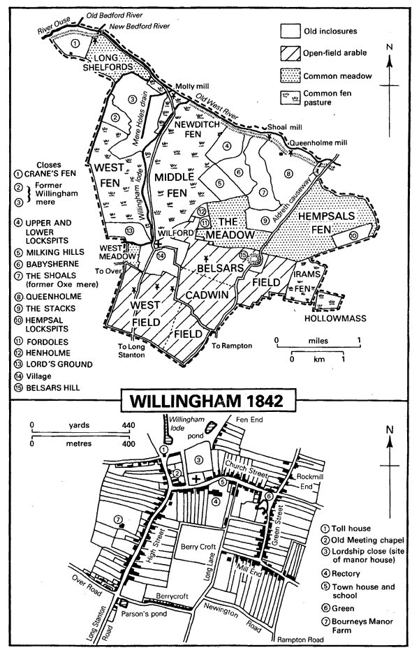
The parish of Willingham, (fn. 1) until the 18th century also known as Wivelingham, (fn. 2) lies on the fen edge south of the river Ouse or Old West River, forming a triangle with a base on the river and an apex to the south. It covered 4,694½ a. until 1884, when a detached part of 35½ a. was transferred to Rampton, leaving 4,659 a. (1,885 ha.). (fn. 3) The parish is almost flat, rising from 2 m. (6½ ft.) by the river to 7 m. in the village and 9 m. in the south. Gravels underlie the south-west part and the village, clays the south-east. Much of the north is covered with alluvium and the north-east is peat fen. Patches of gravel form several drier sites within the fen and the beds of two former meres are marked by shell marl. (fn. 4) Although piecemeal inclosures in the fens were made in the Middle Ages and the 17th and 18th centuries, the parish remained dependent on common pastures and a relatively small area of open fields until the mid 19th century. Proposals to inclose were successfully opposed in 1800 and 1812 (fn. 5) and inclosure took place under an Act of 1846, (fn. 6) the award being executed in 1853. (fn. 7) From the late 19th century Willingham was involved in horticulture. The village is notably large and compact.
The parish boundaries in the south, mainly following straight tracks, were presumably fixed before ploughland extended to them, though that on the south-east partly follows medieval furlong divisions. The greater part of the western boundary was determined c. 1618 when fen pastures intercommoned by Willingham and Over were partitioned by a ditch 12 ft. wide. (fn. 8) Long Shelfords and Crane's fen (formerly Little Shelfords) in the north-west were already wholly within Willingham. Hempsals fen, nearly 500 a. on the east side of the parish, was intercommoned by Willingham and Rampton in 1635. (fn. 9) The arrangement of parish boundaries in Irams fen south of Hempsals suggests that it too was once intercommoned. (fn. 10) The detached part of Willingham in Irams originated as an allotment by the Bedford Level Corporation in 1665 to the lord of Willingham, Richard Holman, (fn. 11) its later name of Hollowmass corrupted from Holman's. The rest of the northern part of the boundary between Willingham and Rampton was fixed before 1665. (fn. 12)
In the Middle Ages there were two meres. Willingham mere in the north-west was the larger. It was said in 1575 to cover 380 a., (fn. 13) perhaps the maximum extent that might be flooded, since the area permanently under water was probably c. 80 a. (fn. 14) In 1655 the mere and adjacent grounds partly liable to flood still covered c. 380 a. (fn. 15) In the early 17th century the main flow into the mere was from Willingham lode, its name suggesting an artificial cut, which began near the village; other streams and drainage channels fell into it from Over. (fn. 16) The mere was being drained in 1696 when Over paid £50 compensation for interference caused by its own drainage works. (fn. 17) By the 1720s the mere had been drained and the lode ran directly into the Old West River. (fn. 18) A straight drain was cut through the former mere bed between c. 1811 and 1836, the lode being diverted to the east. At first called Mere Holes drain, later Willingham engine drain, the new cut received all the streams and ditches west of the lode. (fn. 19) A smaller body of water east of Willingham mere was called Alkesmere in the mid 13th century (fn. 20) and Aux or Oxe mere c. 1620. (fn. 21) It was probably wet only seasonally by 1600 and disappeared shortly afterwards. (fn. 22) In the late 16th century small boats could row east along New ditch from Willingham mere to ditches flanking Aldreth causeway and thence to the Ouse even in July. (fn. 23)
The lower parts of the parish around the meres were probably inundated almost every year before the mid 17th century. (fn. 24) By 1605 the parish had flood banks south of the meres to protect the area between the lode and Aldreth causeway from their overflow, though the banks were inadequate in winter. (fn. 25) Sir Miles Sandys built Bathing bank shortly before 1618 to block the eastern outlet of Willingham mere and prevent it from overflowing into Oxe mere and flooding newly inclosed land nearby. (fn. 26) Restricting the mere with banks caused flooding upstream. A new outlet from the mere to the river was cut c. 1636. (fn. 27) After 1650 the Bedford Level Corporation's sluice at Earith diverted the entire flow of the Ouse from the Old West into the New Bedford River, stopping the main cause of floods in Willingham. (fn. 28) Draining and the inclosure of drained land were forcibly opposed by some of the inhabitants in 1654. (fn. 29) About 224 a. were allotted in 1658 to the Bedford Level Corporation: 53 a. at Hempsal Lockspits, 77 a. at Upper and Lower Lockspits in Middle fen, 53 a. between Willingham mere and the Over boundary, and 41 a. in small parcels elsewhere. (fn. 30) In 1665 the Corporation allotted 59 a. in West fen to the lord of Willingham manor, probably in lieu of common rights. It was later called Lord's Ground. (fn. 31)
A drainage windmill was at work on Sir William Hinde's land in Little Shelfords by 1605. (fn. 32) Later windmills by the Old West lifted water from the main drainage ditches into the river. In the 1830s Crane's Fen mill stood at the head of a drain between Crane's fen and Long Shelfords, Queenholme mill, built by 1719, near the farm of that name, Shoal mill 500 m. west, and the most important, Molly mill, earlier Weathersome or White's mill, at the end of Mere Holes drain. (fn. 33) Owned in 1837 by Thomas Frohock & Co., (fn. 34) it was replaced by a steam engine in 1848 after the formation of the Willingham West Fen drainage commission. Steam power was succeeded c. 1902 by an oil engine and the latter in 1936 by diesel pumps. After 1967 electric pumps in Over were used (fn. 35) but the engine house was preserved c. 1975 by industrial archaeologists. (fn. 36) Under an Act of 1842 to improve the drainage of 2,300 a. in Willingham east of the lode, Cottenham engine drain was dug parallel to the Old West River to take water to a steam pumping engine in Cottenham. (fn. 37)
The fen edge north and east of the village was densely settled from the 2nd century A.D., though all the known sites were abandoned in the wetter conditions of the post-Roman period. (fn. 38) Aldreth causeway, perhaps a Bronze Age route, crosses the eastern part of the parish. (fn. 39) On the edge of the fen it passes through Belsars Hill, a ringwork which may date from 1071 in its present form. (fn. 40) In the Middle Ages the causeway was the main Cambridge-Ely road. (fn. 41) In the 18th century a road from Cambridge to Sutton passed through the open fields and used the causeway to cross the fens. (fn. 42) High bridge over the Old West was in the 18th and 19th centuries often usable only with care or not at all (fn. 43) and in the 20th century the causeway deteriorated to a muddy track.
By the early 18th century, probably from c. 1650, there was an important bridge across the Ouse at Earith sluice, reached by a road which led north from Willingham alongside the lode and the Old West River. (fn. 44) Before the construction of the Cambridge-Ely turnpike in 1768 it was said that the only carriage road between the two towns lay through Willingham village, presumably referring to that road rather than the causeway. (fn. 45) The road was rebuilt c. 1827 probably by the parish, which in 1830 had a tollgate at the north end of the village. In 1830 the road was considered the pleasantest and shortest route between Cambridge and the fens. (fn. 46) Under the Inclosure Act of 1846 its course alongside the lode was stopped and a new straight road was built to the east. (fn. 47) The tollhouse was sold c. 1928 (fn. 48) and later demolished. Droveways in the fens included one leading directly from the village to Flat bridge over the Old West and another to Queenholme. Tracks led across the open fields south and east of Willingham to neighbouring villages, some of which were stopped at inclosure, leaving open only Over Road, Rampton Road, and Stanton, later Station, Road. (fn. 49) Throughout the 19th century three or four carriers ran between Willingham and Cambridge; two of them were based at Willingham in 1883. (fn. 50) The railway from Cambridge to St. Ives, opened in 1847, had a station 750 m. south of the parish boundary, nominally serving Long Stanton; the line from St. Ives to Sutton, with a station at Earith Bridge, was opened in 1878 and crossed the northern corner of the parish. (fn. 51) Earith Bridge station closed to passenger traffic in 1931 and the line was removed in 1958. Long Stanton station closed in 1970 (fn. 52) but a single track remained in 1982. An Act of 1869 for a railway between Haddenham and Long Stanton, passing through Willingham east of the village, was not put into effect. (fn. 53)
Willingham 1842
Willingham has nearly always been among the most populous villages in Cambridgeshire. The number of occupiers grew from 23 in 1086 (fn. 54) to 79 in 1251. (fn. 55) In 1377 the poll tax was paid by 287 adults. There were 105 households in 1563 and 137 houses in 1664. (fn. 56) In 1728 there were said to be 150 families (fn. 57) and by 1801 183 families included nearly 800 inhabitants. The population rose rapidly to over 1,600 in 1851 despite a pause in the 1830s partly due to emigration to America. Numbers fluctuated but did not change greatly over the century after 1851, falling until 1881, recovering the loss and adding more by 1931, but falling back to c. 1,600 in 1951. The population grew a little in the 1950s and quickly in the 1960s, reaching 2,500 by 1981. (fn. 58)
In 1575, when 107 commonable and 7 noncommonable houses were recorded, the village comprised three principal and several lesser streets, intersecting mainly at right angles and lined by blocks of tofts. (fn. 59) The compactness and regularity of the plan suggest that the village grew by several planned stages after the late 11th century. The spine of the village was Church Street linking the green on the east to the church near its west end. In 1575 High Street, running north and south to the west of the church, was built up on both sides, to the north for a short distance and to the south as far as the junction with the Over road. At the north end an irregular cluster of houses stood around the village pound and north-east of the church a row called Fen End faced Fen End pond. Running north and south from the green was the third principal street, Throckwell, Throcknole, or Rockmill End, at its southern end meeting a cross road called Mill End, later Silver Street. Rockmill End was built up on both sides in 1575, Mill End on the south only. The plots of houses facing High Street, Church Street, and Rockmill End backed on Berry croft, around which their owners were granted a right of way in 1602. (fn. 60) Long Lane left Church Street c. 125 m. west of the green and, as Cambridge way, extended south to the Long Stanton boundary until its southern part was closed in 1853.
By the 1720s a further 24 houses had been built on divided tofts and on new sites at the south end of High Street and east of Mill End. (fn. 61) In 1801 there were 146 houses. Their number did not rise in line with the growth in population for the next 20 years but then increased from 168 in 1821 to 293 in 1831. By 1841 much infilling along the main streets had taken place and cottages had been built along Over Road and Long Lane, in yards leading off Church Street, and in Berrycroft, a new street south of Berry croft. The newly occupied streets, except Long Lane, were mostly given over to labourers' cottages. Terraces of somewhat larger houses included British Terrace by 1861, demolished by 1982, and the late 19th-century Lordship Terrace in Fen End. Most of the farmhouses were in High Street, Church Street, and Green Street, the new name for Rockmill End south of the green. In 1881 there were c. 360 houses in the village, 40 more being added by 1901. In the early 20th century detached houses and bungalows, many with market gardens or orchards, extended along Earith Road, Rampton Road, and Station Road. Many council houses were built after 1945, especially in the 1960s and 1970s: by 1982 there were c. 70 on or near Over Road, c. 50 in Mill Field south of the village, and nearly 100 in Wilford Furlong, the latest of the estates to be developed, with others scattered elsewhere. Private house building in the 20th century was at first confined to the ribbon development of Station, Earith, and Rampton roads, but by the 1970s had also filled the remaining spaces in Long Lane, Newington Road, Fen End, and gaps in the centre of the village caused by the demolition of old cottages. By 1971 the parish had 865 houses. (fn. 62) In 1973 the county council was planning to permit more against the opposition of the parish council. (fn. 63) Proposals for new houses west of Rampton Road were rejected in 1977 because the sewage works at Over was already inadequate, (fn. 64) but by 1982 work had begun on a private estate south of Berrycroft, planned to contain 131 dwellings.
The most serious of numerous mid 19thcentury fires were at the time of the Swing riots in 1830, during an outbreak of incendiarism in 1851 and 1852, and in 1859. (fn. 65) Only about a dozen of the houses standing in 1970 dated from before 1700. (fn. 66) Among the more notable is Church Farm in Church Street, two-storeyed, timber-framed, and thatched, with an end-jettied cross wing on the east. Other 17th-century houses, many of them timber-framed and cased in brick, survive in High Street and Church Street. Several farmhouses in the village were rebuilt in the 1820s in buff-coloured gault brick. They are usually of three bays with a central entrance and some have external shutters on the ground-floor windows.
The only farmhouse outside the village c. 1811 was at Crane's fen. (fn. 67) Queenholme Farm was built between 1811 and 1841. (fn. 68) After inclosure in 1847 c. 9 farmsteads were built in the fens but not all had houses or even cottages and most farmers still lived in the village. (fn. 69) A hamlet grew up during the 19th century in the northern corner of the parish at the Hermitage, named from a medieval chapel across the river in Earith (Hunts.). (fn. 70) The Hardwicke Arms, owned by the Bedford Level Corporation, was open there by 1830. (fn. 71) By 1897 there were also the tollhouse for Earith bridge, a house for the keeper of Earith sluice, and three other cottages. (fn. 72)
The earliest recorded alehouses in the village were the George in 1665 and the Five Bells in 1671. (fn. 73) Up to 10 were licensed in the period 1764-1828 (fn. 74) and there were c. 16 public houses and beerhouses later in the 19th century. (fn. 75) The George and the Vine were perhaps the main inns in the late 19th century, (fn. 76) being joined in the 1910s by the White Hart. (fn. 77) There were 7 public houses in 1933 (fn. 78) and 5 in 1982, of which the longest established was the Duke of Wellington, called the Warriors in 1765. (fn. 79)
The village had a flourishing social life in the 19th century. An agricultural society was founded c. 1846 and in 1848 established an annual ploughing match, still held in 1977. (fn. 80) Cricket matches were being held in 1841. A debating society was recorded in 1854, a book society in 1870, (fn. 81) and a small public reading room had been opened by 1883. (fn. 82) The Star Club operated as a benefit society from 1874 until after 1945 and a village nurse was provided by a voluntary association in 1908. (fn. 83) The Willingham & District Permanent Benefit Building Society, founded in 1890, was wound up in 1956. (fn. 84) A public hall was built in High Street in 1896 (fn. 85) and after a period of disuse c. 1970 (fn. 86) was open again by 1982. A recreation ground of 5 a. north of the village was allotted under the inclosure award of 1853 (fn. 87) and another of about the same size was made on a piece of land next to West Fen Road bought in 1898. (fn. 88) A new pavilion was opened on the latter in 1973. (fn. 89) By 1982 Willingham Social Club had a new building in the village. (fn. 90) The rectory house was bought by the county council in 1953 and turned into an old people's home called Willingham House. It had 37 residents in 1982. (fn. 91)
The parish provided two fire engines by 1851, one housed in the church porch until the 1890s, the other in a shed on the green. (fn. 92) The Willingham Water and General Supply Co. was established in 1912 and built a water tower by Station Road. Its system was taken over by Chesterton rural district council in 1955. (fn. 93)