A History of the County of Essex: Volume 4, Ongar Hundred. Originally published by Victoria County History, London, 1956.
This free content was digitised by double rekeying. All rights reserved.
'Chigwell: Introduction', in A History of the County of Essex: Volume 4, Ongar Hundred, ed. W R Powell (London, 1956), British History Online https://www.british-history.ac.uk/vch/essex/vol4/pp18-22 [accessed 30 April 2025].
'Chigwell: Introduction', in A History of the County of Essex: Volume 4, Ongar Hundred. Edited by W R Powell (London, 1956), British History Online, accessed April 30, 2025, https://www.british-history.ac.uk/vch/essex/vol4/pp18-22.
"Chigwell: Introduction". A History of the County of Essex: Volume 4, Ongar Hundred. Ed. W R Powell (London, 1956), British History Online. Web. 30 April 2025. https://www.british-history.ac.uk/vch/essex/vol4/pp18-22.
CHIGWELL
Chigwell lies in the south-west corner of Ongar hundred, on both banks of the Roding, at a distance of 12 miles from London. (fn. 1) The ancient parish had an area of 5,009 acres. (fn. 2) It contained three distinct sections. The village of Chigwell, on the east side of the Roding, was the main settlement and included the parish church. Chigwell Row, a mile south of the village, was a roadside hamlet on the edge of Hainault Forest. The third section was Buckhurst Hill, 1½ mile from the village on the west bank of the river. Until the 19th century much of Buckhurst Hill was within Epping Forest and there were only a few scattered houses in that part of the parish before the modern development took place. The soil of the parish is mainly London Clay, but there are thin patches of glacial gravel in and around Chigwell village and smaller patches at Buckhurst Hill and Chigwell Row.
For ecclesiastical purposes the ancient parish was divided by the formation of the district of Buckhurst Hill in 1838 and that of Chigwell Row in 1860. Both these districts became separate ecclesiastical parishes in 1867. (fn. 3) Buckhurst Hill was made a separate urban district in 1895. (fn. 4) Chigwell and Chigwell Row together constituted the civil parish of Chigwell from 1895 until 1933, when that parish was merged with the Urban Districts of Buckhurst Hill and Loughton to form the new Urban District of Chigwell. (fn. 5)
For several centuries the south-west end of the parish and Chigwell Row have been predominantly residential, with houses occupied mainly by people with interests in London, while the rest of the parish has always been devoted to agriculture. Modern development has emphasized this contrast. Buckhurst Hill and much of Chigwell Row have been built up but Chigwell village has retained its rural appearance.
From the west bank of the Roding the ground rises steeply from about 50 ft. to 267 ft. at Buckhurst Hill, and then falls to about 150 ft. at Ching Brook, which roughly defines the western boundary of the ancient parish. On the east of the river the land rises to 213 ft. in Chigwell village and then falls away to Chigwell (formerly Edensor's) Brook, which flows south-west from the centre of the parish to join the Roding near Luxborough. South of the brook the land rises to Grange Hill (235 ft.) and the ridge of Chigwell Row (280 ft.). From these heights there are long views over the Thames valley to the hills of Kent. Near the northeast boundary is Lambourne Brook, another tributary of the Roding.
Chigwell was formerly in the forest of Essex and two small patches of woodland still exist within the area of the ancient parish. Lords Bushes at Buckhurst Hill cover 90 acres belonging to Epping Forest. At Chigwell Row there are some 50 acres which form part of Hainault Forest.
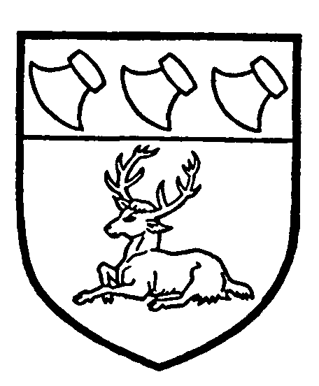
Chigwell Urban District
Or, a stag at rest proper, on a cheif gules three axe-heads bendwise sinister with blades down-words argent. [Granted 1951.]
The main road from London to Ongar, here called High Road, passes north-east through Chigwell village. From the village Roding Lane runs west to Buckhurst Hill; near the lane on the east bank of the river are the R.A.F. Station, Chigwell, and the Buckhurst Hill County High School for boys. The R.A.F. Station is on the site of the ancient manor house of Chigwell Hall. Beyond the river to the west Roding Lane passes a public park and finally joins Palmerston Road, Buckhurst Hill.
Buckhurst Hill is a residential area developed mainly during the past century. It consists of an inner ring on both sides of the railway station, dating from about 1850-1900, with building to the north and south mainly of 1920-39. From West Buckhurst Hill the Loughton road and the Epping New Road run north, the London road (via Woodford) runs south and the Chingford road runs west.
From Chigwell village Vicarage Lane runs southeast to Chigwell Row. Half a mile north of the village on the High Road are Rolls Park and the site of Barringtons (see Manors). Opposite Rolls the main road is joined by the road leading from Loughton via Loughton Bridge. North of Rolls the main road is called Abridge Road. Half a mile north-east of Rolls, immediately south of the Roding, is Woolston Hall (see Manors). Pudding Lane and Gravel Lane run south from Abridge Road near Woolston to Chigwell Row.
Half a mile south of Chigwell village High Road joins Hainault Road which leads to Grange Hill, and then via Fencepiece Road to Ilford. A mile south-west of Chigwell, to the west of High Road is Great West Hatch (see Manors) and near this on the opposite side of the road is the Manor House (formerly the Bowling Green, see Manors). Luxborough Lane, leading from Great West Hatch north-west to Buckhurst Hill, takes its name from an ancient manor in this area.
High Road leaves the parish just before reaching Woodford Bridge. Manor Road, leading from Woodford Bridge to Chigwell Row enters the parish immediately to the south of the Manor House. Between Manor Road and High Road at this point there is a small built-up area dating mainly from about 1900. There is recent ribbon-development farther east on Manor Road before the junction with Hainault Road. At Grange Hill there is a housing area of 1920-39, and in Fencepiece Road there is some similar development and also some houses built since 1945. To the east of Grange Hill is the large Hainault housing estate built since 1945 by the London County Council. Part of this is in Chigwell Urban District, and part in the Boroughs of Ilford and Dagenham. Other houses west of Chigwell Row are mostly modern. From Chigwell Row Romford Road runs south-east to Romford and Dagenham. Manor Road continues east of Chigwell Row to Lambourne End as Lambourne Road.
Chigwell village, Chigwell Row, Gravel Lane, and Pudding Lane contain a number of houses dating from the 17th and 18th centuries, many of which are described below.
The railway from London to Epping passes through Buckhurst Hill, where there is a station. A loop line from Woodford to Hainault, Newbury Park, and Leytonstone branches east from the Epping line. There are stations at Roding Valley (South Buckhurst Hill), Chigwell (½ mile south of the village), and Grange Hill. Hainault station, which serves the London County Council estate, is just outside Chigwell parish. Both these lines are now electrified and form part of the Central London Line.
Before the 17th century the repair of the parish roads was largely a matter of charity, and many bequests were made for this purpose, for example, those of Cicely Rypton (1551) (fn. 6) and George Scott (1588). (fn. 7) In 1592 the surveyors of Chigwell presented eight parishioners at Quarter Sessions for refusing to do their statute duty on the roads. (fn. 8) In 1682 the Woolston manor court presented the surveyors themselves for failing to repair a footbridge and threatened them with a penalty of £5 if they failed in the future. (fn. 9)
The most important road in the parish in early times was the London-Abridge road, which was also the main road (via Theydon Bois) to Epping. This follows closely the line of an old Roman road, passing near the site of a Romano-British settlement near Woolston. (fn. 10) The charity founded in 1557 and 1562 by Joan Sympson for the repair of this road is described below (see Charities). Her endowment was regularly used for this purpose in the 16th and 17th centuries, (fn. 11) but in spite of it ten rods of the road between Chigwell village and Abridge were in a bad condition in 1647. (fn. 12) From 1763 the road was maintained by the Middlesex and Essex Highway Trust. (fn. 13) In 1866 the parish resumed responsibility for the road. (fn. 14) In 1668 part of the road between Chigwell and Abridge was diverted near Rolls to enable the owner of that house, Sir Eliab Harvey, to extend his grounds. (fn. 15)
It is remarkable that until 1890 there was no proper road between Chigwell and Buckhurst Hill. Before that there was only a track running from Luxborough Lane, through the Roding and along Squirrels Lane, which lay approximately on the line of the present Lower Queen's Road, Buckhurst Hill. This track was often obstructed. (fn. 16) A 'church way' from Buckhurst Hill to the parish church at Chigwell existed in 1586. As it included three stiles it was presumably a footpath. (fn. 17) The construction of a new road across the Roding from Buckhurst Hill to Chigwell was discussed by the parish vestry in 1855 and 1864. Nothing, however, was achieved until in 1890 the present Roding Lane was opened. (fn. 18) Before this the people of Buckhurst Hill could only reach Chigwell, without fording the river, by way of Woodford or by Loughton Bridge.
Gravel Lane, (fn. 19) Pudding (formerly Patsalls) Lane, (fn. 20) Vicarage Lane, (fn. 21) and Hainault Road (formerly Fortey or Horn Lane) (fn. 22) all figure in records from early times. They were all gated at the forest end to keep out stray animals. (fn. 23) The gate house at the upper end of Hainault Road still exists.
The road from Grange Hill to Ilford was not made until 1833, and that from Chigwell Row to Romford about 30 years earlier; both were paid for by public subscription. (fn. 24) In the former case, however, a track must previously have existed, for in 1662 Fortey Lane was described as the road from Chigwell to Barking. (fn. 25)
Manor Road undoubtedly replaced an ancient track. (fn. 26) As late as 1817, however, it was held that it was not a public highway because it was only a 'fair weather road'. (fn. 27) Its extension from Chigwell Row to Lambourne End (c. 1790) has been described under Lambourne.
At Buckhurst Hill the Loughton-Woodford road is of ancient origin. It became important early in the 17th century when the road from Loughton to Epping through the forest was completed, thus providing a new direct route from London to Newmarket. (fn. 28) In the 18th century it came under the control of the Epping and Ongar Highway Trust, which about 1780 remade the section between Buckhurst Hill and Loughton. (fn. 29) In 1834 the trust completed its new road from Woodford to Epping, by-passing Loughton. (fn. 30) A short stretch of this Epping New Road runs through Buckhurst Hill.
The only other roads in Buckhurst Hill before the 19th century seem to have been a lane leading from the 'Bald Faced Stag' to Langfords (now Westbury Lane) and another, on the opposite side of the main road, leading to Whitehall in Chingford (now Whitehall Lane). In 1791 and 1796 the parish resisted magistrates' orders to repair the latter road. (fn. 31) Of the newer roads in Buckhurst Hill Queens Road was taken over by the parish in 1867, Princes Road and Victoria Crescent in 1870, Victoria Road in 1881, and Alfred Road, Albert Road, Gladstone Road, and Russell Road in 1883. Kings Place Road was taken over in sections in 1870, 1879, 1881, and 1883. (fn. 32)
The combined Domesday figures for Chigwell Hall and Woolston give a total of 23 villeins, 4 bordars, and 8 freemen in 1066, to which a further 4 bordars had been added by 1086. (fn. 33) In 1391 there were 72 houses in the parish. There was a small concentration round the church in Chigwell Street but most of the houses were scattered throughout the parish. (fn. 34) They probably included most of those known to have existed in the 15th century, among which were the following: (fn. 35) Little Londons, Turnours, Martins (now Marchings), Brownings, Serjeants, Birds, and Coles (now Taylors Farm) in Gravel Lane; Billingsbourne in Millers Lane (off Gravel Lane); Pettits and Barns alias Fulhams in Pudding Lane; Appletons (now Old Farm) in Green Lane (a track off Vicarage Lane); Tailours and the manor house of Barringtons (later Rolls) in High Road, and Woolston Hall off Abridge Road. At Chigwell Row were Sheepcotes, near the Lambourne boundary, Whitehall (formerly Gullivers) with Goodhouse and Haywards near by, Skynners which later became the 'Maypole' and stood behind the site of the more recent inn of the same name, Old Bennetts, Hatchmans, Pearsmiths, and Page Hall, all of which stood near the present Hainault Hall, and Hatch House near the later Clare Hall, with perhaps a dozen smaller houses. At Grange Hill there was Grange Farm and in Hainault Road, Elces (formerly Youngs). In Chigwell village a few houses are known to have existed in the Middle Ages, and in the 15th century there were probably more than a dozen, including the Grange, Church House, and Ringleys on the site of Grange Court. Farther south in High Road there were houses at Broomhill and West Hatch, Brookhouse Farm and the old mansion at Luxborough. At Buckhurst Hill there were a few houses in the 15th century, among them King's Place and Monkhams.
Some of these houses have disappeared and the others have been rebuilt or so much altered as to leave few traces of their early origin. Among the oldest surviving houses in the parish are the Retreat at Chigwell Row, Woolston Hall (see Manors), Marchings, and Brownings, all of which date from the 16th or early 17th centuries. Marchings is a two-story house, timberframed and roughcast. It was probably built early in the 16th century but has been much altered. Brownings is a two-story building, also timber-framed and roughcast, with an old tile roof. It has a front of three gables, the centre one being much wider than the others. The Retreat, now a café, was probably built in the 16th century but only a small part of the present building is original. There are old timbers inside. Details of some Chigwell houses and their furnishings in the 15th-17th centuries are contained in the printed series 'Old Chigwell Wills'. (fn. 36)
In 1671 there were 168 houses and two forges in the parish. (fn. 37) In addition to the houses already mentioned were Bacons (on the site of Montfort House), Morgans (later Great House and now the Grove), Wheelers alias Butlers Bennetts (now the Chace), Langhall (now the Foxhounds), Taylors Hall (on the site of Willow House), Clare Hall, Bowls, and some cottages, all in Manor Road. In Pudding Lane Clark's tenement (later Burnt House) had been built and in Chigwell village there were houses on nearly all the present sites. The original manor house of Chigwell Hall had fallen into disuse after the building of a new house near the church (see Manors). Existing houses which in their present form date from the 17th century are the 'King's Head', Chigwell School, Harsnetts, Woodlands at Chigwell Row, the Foxhounds, Brookhouse Farm, Church House, Pettits Hall lodge, Turnours and possibly Grange Court.
The 'King's Head' in Chigwell village was made famous by Dickens in Barnaby Rudge, where it figures as the 'Maypole'. It was an important inn. From 1713 and possibly earlier it was regularly used for meetings of the Court of Attachments of Waltham Forest. (fn. 38) In the 1850's it was a favourite resort of public authorities banqueting at the public expense, and was famous for pigeon pie. (fn. 39) The main part of the building is of three stories with attics and cellars and exposed timberframing. Each upper story overhangs and there are four various-sized gables. There is a large roughcast chimney-stack with diagonal shafts. There have been many alterations and additions to the building. The Chester Room on the first floor has 17th-century panelling.
The original part of Chigwell School was built soon after the foundation of the school in 1629. (fn. 40) It is a one-story building of red brick with an old tile roof. There have been additions in the 18th century and later. Harsnetts is a two-story building opposite the school, now divided into two houses.
Woodlands, at Chigwell Row, is a two-story building, roughcast, with a tile roof and a rebuilt chimneystack of four shafts. The 'Fox and Hounds' consists of two stories and attics and is of red brick. Brookhouse Farm is a timber-framed and roughcast building having an old tile roof and a central chimney-stack with six diagonal shafts. Church House, though mainly of the 18th century, incorporates obvious remains of a 17thcentury building, including a chimney-stack. It is of two stories, timber-framed, and roughcast. Pettits Hall lodge is of similar construction, with a cross gable overhanging to the right. (fn. 41) Turnours, on one of the oldest sites in the parish, is particularly interesting. In the entrance hall there is a fine 17th-century fireplace. Late in the 19th century the house was encased in red brick in Gothic style. Cloisters were built on the north side and a chapel behind the house to the west. These alterations were probably planned by Miss Ada Palmer. The Palmers lived at Turnours from about 1860 to about 1914. (fn. 42) Ada was a painter and sculptor and many of her works are preserved in the house. During the Second World War Turnours was used for military purposes and a hutted camp was built in the fields to the north-west. After the war the house was acquired by Dr. N. Beattie of Ilford and maintained by him as an International Youth Centre. (fn. 43) Grange Court, which was remodelled in 1774 was probably built in the late 17th or early 18th century. It is a large and handsome three-story house with lower side wings, and is built mainly of stock brick. It is now part of Chigwell School.
During the 18th and early 19th centuries several new houses were built in the parish and many old ones greatly altered or completely rebuilt. Among those which in their present form date from the 18th century are Chigwell Lodge, Brook House, the stables at Barton Friars (originally the stables to Grange Court), Vine Cottage, and Tailours, in High Road, and Sheepcotes and Hainault Hall at Chigwell Row. Flint Cottage, The Haylands, Little Haylands, and Belmont Park, in High Road, are of the early 19th century. Crosby House at Chigwell Row is an early-19th-century remodelling of an 18th-century house. Great West Hatch, New Barns in Luxborough Lane, and Barrington Lodge and Forest House at Chigwell Row were entirely new houses built in the 18th century. Many smaller houses also date from the 18th and earlier 19th centuries. The old house at Luxborough was replaced about 1720 by a large mansion, but this was demolished about 1800. There was small-scale but continuous new building throughout the parish and by 1851 there were 396 houses of all sizes. (fn. 44)
The population of the parish was 1,351 in 1801. By 1841 it had risen to 2,059. It declined slightly to 1,965 in 1851. (fn. 45) Between 1850 and 1870 Chigwell Row was greatly changed by the inclosure and destruction of most of Hainault Forest (see Agriculture). At Buckhurst Hill part of Epping Forest was inclosed and some of it built over.
The rapid building at Buckhurst Hill was a result of the extension of the railway from Woodford to Loughton. By 1871 there were 1,080 houses in Chigwell parish, nearly all the increase being at Buckhurst Hill. (fn. 46) The only other building of any importance had been in Hainault Road. (fn. 47) By 1891 the number of houses had increased to 1,271. (fn. 48) The population of the parish rose to 6,324 in 1891 and 7,294 in 1901. (fn. 49)
It is interesting to compare the development of Buckhurst Hill between 1851 and 1901 with that of Loughton (q.v.). Both places were affected at the same time by the coming of the railway and both were involved in the controversy concerning the inclosure of Epping Forest. (fn. 50) At Buckhurst Hill development was much more rapid than at Loughton and was much more concentrated round the railway station. Inclosures from the forest were much smaller at Buckhurst Hill than at Loughton, mainly because Buckhurst Hill had a smaller forest frontage, but most of the inclosures at Buckhurst Hill were more quickly built over and thus became exempt from the provisions of the Epping Forest Act of 1878. Loughton's growth took place within the framework of an ancient village. At Buckhurst Hill a new town sprang up on farm land and forest.
Growth was much slower after 1901. The opening of the Woodford-Ilford loop line in 1903 caused some building in Chigwell village and at Grange Hill, and there was also some development near Woodford Bridge. In 1931 the total population was 8,948 (Buckhurst Hill U.D. 5,486; Chigwell C.P. 3,462). Between 1931 and 1939 there was much new building, in Hainault Road, Manor Road, Forest Lane, High Road, and in various parts of Buckhurst Hill, especially at Monkhams. Shortly before 1939 Chigwell lost one of its oldest houses, the Grange in High Road, which was demolished after a fire. (fn. 51) It dated from the 15th century. (fn. 52)
Since 1945 restrictions have prevented large-scale private building, and much of Chigwell has been designated as a part of 'the Green Belt'. The new Hainault estate, however, has added 1,900 houses to the urban district since 1945. There has also been some building of local council houses. The Grange Farm Camp, Chigwell, opened in 1951, provides large-scale facilities for camping, swimming, and many other types of athletics (see also Charities). In 1953 the population of Chigwell Ward was estimated at 14,000 and that of Buckhurst Hill Ward at 12,000. (fn. 53)
There was a regular coach service from Chigwell to the 'Blue Boar' at Aldgate from 1790. (fn. 54) In the 1820's Mary Draper of the 'King's Head' ran a daily service to Aldgate. (fn. 55) In 1840 a coach left the 'Maypole' at Chigwell Row every morning, calling at the 'King's Head' on its journey to the 'Three Nuns', Whitechapel, and returning by the same route in the evening. (fn. 56) In 1845 the Ongar coach to London also passed the 'King's Head'. (fn. 57) William Powling kept a coach at his house next to the 'Maypole' at Chigwell Row; from 1844 it ran from there to the 'King's Head' and back to connect with the Ongar coach. (fn. 58) After his death in 1848 (fn. 59) his widow kept two coaches for some years, one ran to London daily and the other to the newly opened railway station at Ilford. (fn. 60) In 1858 these coaches were taken over by William Claydon who in 1864 moved to Vicarage Lane. (fn. 61) For many years before the building of the Ilford loop a coach ran every morning and evening to Woodford station, the Ilford coach being discontinued. (fn. 62) Coaches owned by Nelson of the 'Bull', Aldgate, ran to Chigwell Row until 1868. (fn. 63) In 1848 Henry Chipperfield ran a wagon three times a week from Chigwell to London and John Wilton ran one daily from Chigwell Row. (fn. 64) In 1878 William Claydon ran a wagon to London four times a week. (fn. 65)
Before the building of the railways Buckhurst Hill had many coaches passing through every day, to London, Cambridge, Norwich, Bury St. Edmunds, Dunmow, and elsewhere.
The Eastern Counties Railway extended its line from Woodford to Loughton in 1856, with a station at Buckhurst Hill. In 1903 the Ilford loop was opened, with stations at Chigwell and Grange Hill. (fn. 66) In 1937 a new station was opened at Roding Valley, on this loop, to serve the southern part of Buckhurst Hill.
In 1839 there were postal receiving houses at Chigwell and Chigwell Row. (fn. 67) By 1863 there were two post-offices at Chigwell, and sub-post-offices at Chigwell Row and Buckhurst Hill. (fn. 68) By 1874 there was a telegraph office at Chigwell. (fn. 69) In 1886 there were two post-offices at Buckhurst Hill, one of them having the telegraph, and the Chigwell Row office also had the telegraph. (fn. 70) The telephone was in use at Buckhurst Hill by about 1906. (fn. 71) By 1922 there was a telephone exchange in Chigwell village. (fn. 72)