A History of the County of Essex: Volume 6. Originally published by Victoria County History, London, 1973.
This free content was digitised by double rekeying. All rights reserved.
'West Ham: Stratford Abbey', in A History of the County of Essex: Volume 6, ed. W R Powell( London, 1973), British History Online https://www.british-history.ac.uk/vch/essex/vol6/pp112-114 [accessed 27 July 2024].
'West Ham: Stratford Abbey', in A History of the County of Essex: Volume 6. Edited by W R Powell( London, 1973), British History Online, accessed July 27, 2024, https://www.british-history.ac.uk/vch/essex/vol6/pp112-114.
"West Ham: Stratford Abbey". A History of the County of Essex: Volume 6. Ed. W R Powell(London, 1973), , British History Online. Web. 27 July 2024. https://www.british-history.ac.uk/vch/essex/vol6/pp112-114.
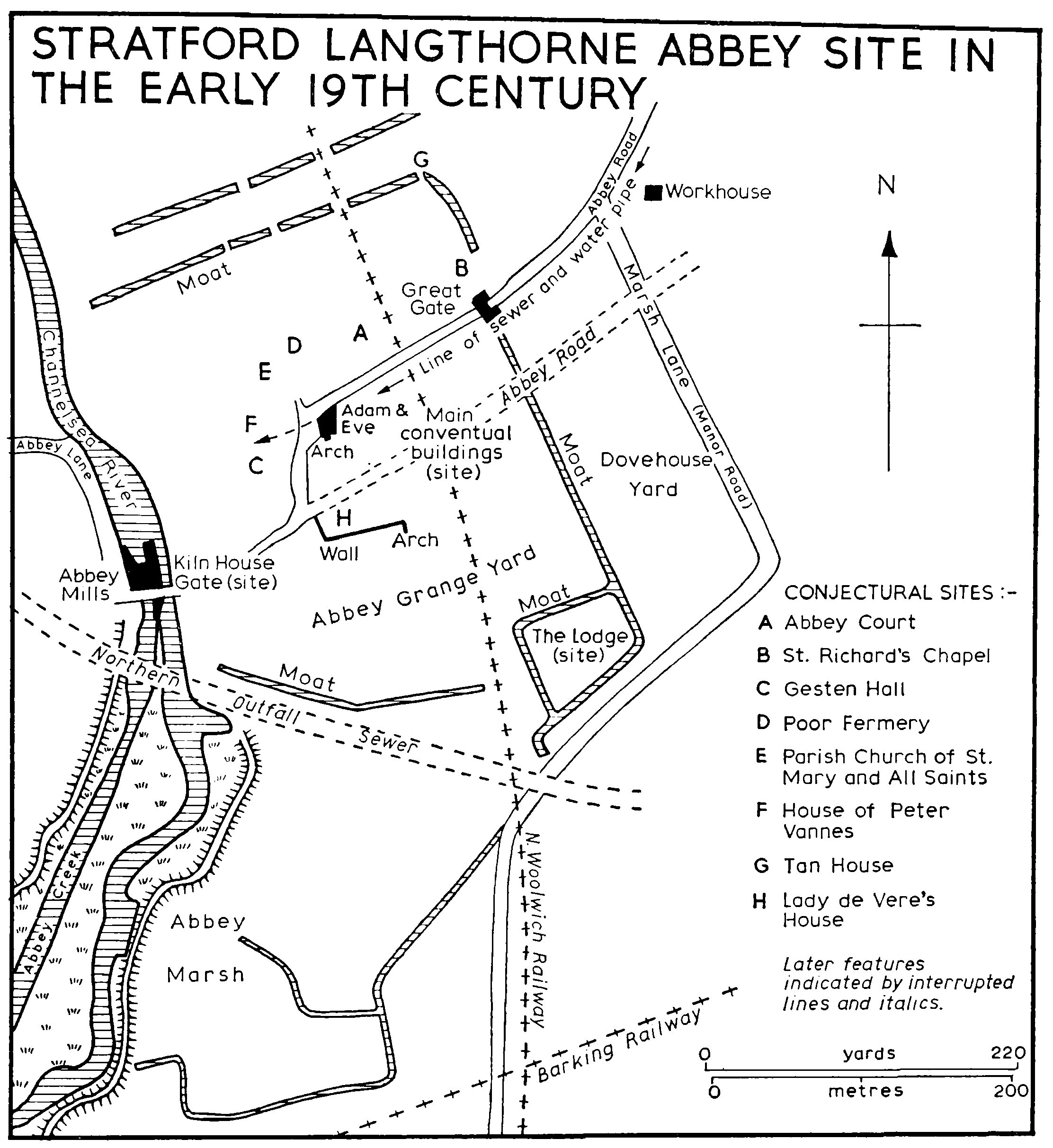
STRATFORD ABBEY PRECINCTS. (fn. 1)
The abbey of Stratford Langthorne lay between the Channelsea river and Marsh Lane (Manor Road) on a site now occupied by factories, railways, and a sewage pumping station. None of its buildings remain in situ. The abbey precincts appear to have comprised about 20 a., moated to north, east, and south. They constituted a separate parish, with its own parish church, distinct from the abbey church. The abbey exercised peculiar jurisdiction within the precincts. (fn. 2)
When the abbey was dissolved in 1538 several of the buildings in the precincts were occupied by lay persons, mostly under leases granted during the past five years. In 1539 the abbey site and the reversion of the other property in the precincts were granted to Sir Peter Meautis or Mewtas (d. 1562), later ambassador to France. During the next two centuries the ownership of the precincts came to be divided between several owners. By 1732 an alehouse, the Adam and Eve, had been built on part of the site. That, with the adjoining land to east and south, was bought in 1784 by Thomas Holbrook (d. 1811), a brewer, who dug up the abbey foundations, used some of the stone for building and sold much of the rest. (fn. 3) In the 1840s the North Woolwich railway was built through the site, running north to south about 70 yd. east of the Adam and Eve. The site was again disturbed by railway works in the 1870s.
STRATFORD LANGTHORNE ABBEY SITE IN THE EARLY 19TH CENTURY
The topography of the precincts is not precisely known and the accompanying plan is partly conjectural. The main conventual buildings were probably demolished soon after the Dissolution. They were clearly in the immediate vicinity of the Adam and Eve. The existence of an ancient waterpipe and an ancient sewer, both running west to the Adam and Eve, suggest that the domestic offices of the abbey to which they were probably connected lay south of the road through the precincts, with the church south of them. Such an arrangement would have been consistent with local custom. In west Essex most of the monasteries of which the plans are known, including Stratford's neighbours at Waltham and Barking, had churches to the south of the other conventual buildings. (fn. 4) Such a layout is also consistent with the position of the abbey court at Stratford which lay on the north side of the precincts. Extensive building seems to have been going on at the abbey in the 13th century. (fn. 5) A great west window in the abbey church was mentioned in 1400 as newly built. (fn. 6) That work may have been connected with the patronage of Richard II, who came to the help of the abbey when it was in financial difficulties resulting from floods and other causes. (fn. 7) Leland's story that floods caused the temporary evacuation of the abbey probably relates to the same period. (fn. 8) When completed the conventual buildings probably occupied a frontage of about 180 yd. on the road through the preeincts, and extended south for some 140 yd. Medieval masonry recorded from that area included a 13th-century arch which survived until c. 1870 in a wall at the Adam and Eve. Fragments of a two-light window of uncertain date, which are now (1971) in the long porch of All Saints church, West Ham, probably came from the conventual site. They were formerly built into a wall west of the Adam and Eve on the opposite side of the road. All Saints church also has an octagonal font bowl which may originally have come from the abbey. It was found on the site of the leathercloth factory just outside the precincts. Another probable relic of the abbey preserved in the church is a stone carved with five skulls. It was found c. 1874 in an ancient burial ground, during railway works near the Adam and Eve. Other sepulchral remains were found in the same area in the 18th and 19th centuries, including stone and lead coffins. It is usually assumed that these were all associated with the abbey, but the mention of urns in one report suggests an earlier period, and it may be significant that the site of the leathercloth factory was once called Barrow field. (fn. 9) Various other objects, since dispersed, have been found at the abbey, including an onyx seal depicting a griffin with the legend 'Nunc vobis gaudium et salutem'. (fn. 10)
Among the buildings in the precincts in 1539 was the Lodge, a moated house lying on the southern side near Marsh Lane. This may well have occupied the site of a manor-house even older than the abbey. (fn. 11) It apparently still existed in 1747, when it was called the Abbey House. Near the west end of the abbey church was a house occupied in 1538 by Lady de Vere and previously by the countess of Salisbury. (fn. 12) It was demolished immediately after the Dissolution. On the north side of the precincts was the parish church, dedicated to St. Mary and All Saints, and near it the 'pore fermery' and the 'gesten hall', both leased as private residences. In the same area were several other unnamed houses, one of which was on lease to Peter Vannes, dean of Salisbury. The gesten hall and Vannes's house appear to have survived until the early 19th century. The Abbey Mill, on the Channelsea river, is treated elsewhere. (fn. 13) Adjoining it were the bakehouse and kilnhouse. The slaughter-house was in the grange yard, near the Lodge. A tannery, in the north-east corner of the precincts, went out of use shortly before the Dissolution. (fn. 14)
The main (eastern) entrance to the precincts was from Abbey Road through the Great Gate, which stood in the present Baker's Row, about 170 yd. from the Adam and Eve. (fn. 15) The gatehouse survived until about 1825. Its outer (eastern) side was of brick, apparently of the late 15th or early 16th century. The inner side was of timber with foliated spandrels. St. Richard's chapel, near the Great Gate, was probably identical with a chapel there mentioned in 1334. (fn. 16) It seems to have disappeared by 1576. The western entrance to the precincts was from Abbey Lane through the Kilnhouse Gate.