A History of the County of Essex: Volume 7. Originally published by Victoria County History, London, 1978.
This free content was digitised by double rekeying. All rights reserved.
'Upminster: Introduction and manors', in A History of the County of Essex: Volume 7, ed. W R Powell (London, 1978), British History Online https://www.british-history.ac.uk/vch/essex/vol7/pp143-153 [accessed 30 April 2025].
'Upminster: Introduction and manors', in A History of the County of Essex: Volume 7. Edited by W R Powell (London, 1978), British History Online, accessed April 30, 2025, https://www.british-history.ac.uk/vch/essex/vol7/pp143-153.
"Upminster: Introduction and manors". A History of the County of Essex: Volume 7. Ed. W R Powell (London, 1978), British History Online. Web. 30 April 2025. https://www.british-history.ac.uk/vch/essex/vol7/pp143-153.
In this section
UPMINSTER
Upminster lies about 15 miles east of the city of London. (fn. 1) It became part of Hornchurch urban district in 1934 and of the London borough of Havering in 1965. The old village at the centre is now a dormitory suburb but there is still farm-land to the north and south. The ancient parish, which contained 3,369 a., was about a mile wide, east and west, and about 6 miles long. Its boundary on the north and west was the Ingrebourne river; ¾ mile south of Hacton Bridge the boundary ran eastwards to the White Hart corner at Hacton, whence it followed the Aveley road south to the stream south of Running Water wood. There it turned east as far as the SE. corner of Little Brickkiln wood before running almost due north for five miles to the SW. corner of Foxberry (or Foxburrow) wood, which it skirted on the west and north. Turning north, the boundary ran through Brick House and continued north for ½ mile or more before turning westwards to rejoin the Ingrebourne. (fn. 2)
Upminister's terrain slopes southwards. In the north of the parish, at Upminster Common (formerly Tyler's Common), the ground rises 200 ft. above sea-level, but it drops in the south to 50 ft. Throughout the parish there is a layer of loam, resting in the south on sand and gravel and in the north on London clay. In addition to the Ingrebourne and the Running Water, another stream north of Corbets Tey flowed westwards across the parish. In the late 18th century it was dammed to form a lake in Gaynes Park. (fn. 3) Until the 19th century the parish was well supplied with springs; on Tyler's common there was a mineral spring praised in the 18th century but in 1910 said to have little or no medicinal value. (fn. 4)
The recorded population of Upminster in 1086 was 39. (fn. 5) In 1670 85 houses were listed in the parish. (fn. 6) In 1695 there were 370 inhabitants. (fn. 7) The number rose to 765 by 1801 and to 1,477 by 1901. (fn. 8) The development of the garden suburb after 1906 took the population in 1931 to 5,732. In 1951 the total for the old parish was 13,038, a figure which appears to have altered little since.
A Romano-British farmstead, occupied throughout the 1st century and in the 3rd century, was discovered west of Corbets Tey during gravel-digging in 1962. (fn. 9) In medieval Upminster there seem to have been three clusters of settlement: the village itself, and the hamlets of Hacton and Corbets Tey. Then as later the village probably lay along the Hornchurch road (now St. Mary's Lane), and centred on the ancient parish church, which stands at the junction with Corbets Tey Road. South of the Hornchurch road and on the western boundary of the parish Bridge House stood in 1375 on the site of the present Hornchurch stadium. (fn. 10) New Place near the eastern boundary was first mentioned c. 1475. (fn. 11) Hacton and its bridge date from c. 1300. (fn. 12) Corbets Tey, named in 1461, presumably takes its name from the 13th century family of Corbin or Corvyn or from the 15th-century John Corbyn. (fn. 13) Keeling's Cottages, in Ockendon Road, were partly of the 15th century, and with the neighbouring Keelings were demolished after 1958. (fn. 14) In addition to the three settlements medieval dwellings were scattered through the parish. (fn. 15) Two which dated from the 15th century still survived in 1974: Upminster Hall a mile north of the village on Hall Lane and Great Tomkyns, in Tomkyns (formerly Bird) Lane. (fn. 16) Great Tomkyns contains within its exposed timber frame a hall rising the whole height of the house. (fn. 17) A 17th-century weatherboarded barn also stands within the partly-dried moat. (fn. 18) Pages (formerly Tithe) Farm, Shepherds Hill, is probably late medieval in origin and there are smoke-blackened rafters, now reset, in the central section of the roof. The hall, chimney, and ceiling are 16th-century insertions and the east (service) wing was rebuilt as a parlour in 1663. (fn. 19)
Settlement in the 16th and 17th centuries followed the earlier pattern: the village and hamlets continued to expand slowly, and isolated farms were built in the north and south ends of the parish. High House and Hoppy Hall, south of the village on the Corbets Tey road, were built in the late 16th or early 17th century; both were demolished in 1935–6. (fn. 20) At Hacton the late-16th-century Park Corner Farm was destroyed by bombing in the Second World War. (fn. 21) Great Sunnings, a farm-house of similar date lying south of Corbets Tey, still survives, but its Jacobean panelling and Adam fire-place were removed and sold between 1945 and 1958. (fn. 22) In Corbets Tey itself several 17th-century buildings survive. They include the Old Cottage, a timber-framed house at the corner of Corbets Tey Road and Ockendon Road. This was the George inn from 1769 or earlier until 1901. Until 1969 it had an elaborate Jacobean fire-place. (fn. 23) Opposite Old Cottage is High House, which has a narrow but elegant late-17th-century brick façade dominating a lower and earlier timber-framed wing. (fn. 24) A row of rendered and weatherboarded cottages (nos. 1–8 Harwood Hall Lane) stands to the west. Nos. 1–3 were originally a single dwelling of the early 17th century, but revealing older methods of construction. It was divided when nos. 4–8 were built in the mid 18th century. (fn. 25)
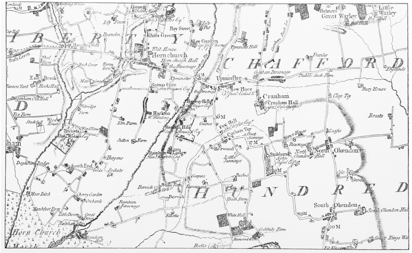
Hornchurch and the central part of Chafford hundred, 1777. From Chapman and André's Map of Essex, reduced to c. 1½ in. to 1 mile.
From the mid 17th century successful Londoners were buying estates in Upminster, and by 1700 Gaynes, New Place, and Upminster Hall manor had been bought respectively by a brewer, a draper, and a mariner. (fn. 26) In his old age Benjamin Braund (d. 1734), a vintner, retired to Corbets Tey, and his bachelor son William (1695–1774), a successful Portugal merchant and City financier, also settled in Upminster. (fn. 27) Between 1762 and 1765 William Braund built Hactons at the junction of Little Gaynes and Hacton Lanes. It is a red-brick house with stone quoins and dressings, the main block being flanked by two lower wings containing kitchens and servants' quarters. After military occupation during the Second World War Hactons stood empty until 1954 when it was converted into flats. The brickwork was painted white, and the roof-line of the main block altered to provide windows for an attic storey. The lack of a view from the north front apparently results from planting first undertaken in the 1840s. (fn. 28) William Braund was outdone by Sir James Esdaile. After inheriting New Place through his second wife, Esdaile bought Gaynes manor in 1770. (fn. 29) He at once undertook a programme of building, renovation, and landscaping which transformed Upminster. (fn. 30) In 1771 he began with the Gaynes chapel in the parish church, and he continued with New Place, High House, Hoppy Hall, Gaynes mansion, the West Lodge, Gaynes Cross, Hunts, and the Bell Inn in Upminster, and in Corbets Tey with Londons and Harwood Hall. (fn. 31) Of these New Place, Gaynes (or Great Gaynes), Hoppy Hall, and Harwood Hall were occupied by members of his family; Londons took its name from Dr. London, the occupant from 1804 to 1819. (fn. 32) In 1974 only two of Esdaile's buildings were still standing: Gaynes Cross (no. 201 Corbets Tey Road) on the site of Gaynes manor pound, and Harwood Hall. The latter, on the lane running from Corbets Tey to Smokeholes on the Aveley road, was built in 1782, enlarged c. 1840, and castellated by 1881. (fn. 33) Some of Esdaile's programme was carried out by Samuel Hammond, his tenant at West Lodge and the builder responsible for much of the building on Upminster Hill (now St. Mary's Lane) in the later 18th century. (fn. 34) Tadlows, no. 251 Corbets Tey Road, is probably another Esdaile building. (fn. 35)
North of the village two 18th-century farm-houses still survive: the brick Chapmans or Potkiln farmhouse at the corner of Hall Lane and Bird Lane, and the weatherboarded Tylers Hall NE. of Upminster Common. In the late 18th century Tylers Hall consisted of a 'farm end' and a 'family apartment' on which the owner claimed to have spent £1,000; Chapmans was enlarged c. 1890. (fn. 36) Fox Hall, Corbets Tey Road, is said to have been built in 1718. It originally consisted of a single block with a highpitched roof and massive flat chimney shafts. A flight of steps led to an ornamental front door. Wings were added at the NW. and SW. corners c. 1817. The house was sold in 1923 and demolished soon after. (fn. 37) In Ockendon Road, Corbets Tey, is the Huntsman and Hounds public house. It existed as a tavern in 1769, and was rebuilt in 1895–6. (fn. 38)
Besides the George and the Huntsman and Hounds in Corbets Tey, there were two other inns in 18th-century Upminster. The Cock at Hacton was the earliest known inn in the parish. It existed in the period 1685–1743, but had closed by 1769. (fn. 39) The Bell, on the SE. corner of Cranham Lane and Corbets Tey Road, was in business in 1769, was built or rebuilt in the 18th century, and sold for demolition in 1962. (fn. 40)
A late-18th-century map shows a road pattern which remained almost unaltered until the 20th century. (fn. 41) From the west three roads entered the parish across the Ingrebourne: the most northerly, Shepherds Hill, skirted the commons on the south and continued as Warley Road; the second, St. Mary's Lane, crossed the waist of the parish from Hornchurch to Cranham; (fn. 42) Hacton Lane, the most southerly, entering the parish at Hacton bridge, ran south to Hacton Corner. It continued as Aveley Road, forming the parish boundary with Rainham and Aveley. (fn. 43) Nag's Head Lane ran south from Brentwood across the common, continuing as Hall Lane to the village and then as Corbets Tey Road. Bird Lane curved south from the Warley road to join Hall Lane at Chapmans or Potkiln Farm. South of the village Gaynes Lane turned west from Corbets Tey Road at Gaynes Cross to join Hacton Lane north of Hacton Corner. At Corbets Tey the road divided: a lane ran westward to join the Aveley road at Smokeholes, while the main road turned east to North Ockendon. Just east of the hamlet a green lane continued south into Aveley, crossing another (Bramble Lane) from Rainham to the Ockendons. In 1774 the two roads running east to the Ockendons were connected by a road immediately west of Stubbers; in 1814 this road was closed and a new one opened on the boundary between Upminster and North Ockendon. (fn. 44) Chafford Heath, the former meeting-place of the hundred, lay south of Corbets Tey at the junction of Aveley Road and Bramble Lane. It still survived, diminished, in 1799, but by 1842 had been absorbed by neighbouring farms. (fn. 45)
The upkeep of the bridges over the Ingrebourne belonged to Upminster alone since Hornchurch, as part of the Liberty of Havering, successfully claimed exemption from responsibility. (fn. 46) Upminster bridge (Bridge House bridge, or Lower bridge) on the Hornchurch-Upminster road, existed in 1375, and in 1617 was a horse-bridge in need of repair. (fn. 47) Destroyed in the winter of 1709–10, the wooden bridge was replaced by another, the county contributing to the cost. (fn. 48) A wooden carriage-bridge was built in 1759, and another in 1827. (fn. 49) In 1888 floods made the bridge dangerous for heavy traffic. The county took it over in 1889, and in 1891–2 built a new bridge of brick and iron more than twice the width of the old one. (fn. 50) A ford beside Upminster bridge was used regularly until c. 1850. (fn. 51)
About a mile downstream from Upminster bridge is Hacton bridge. It was originally manorial and already existed in 1299. (fn. 52) In the 1630s it was a horse-bridge, but in the 1660s inhabitants of the Barstable and Chafford hundreds persuaded the carpenter in charge of its repair to make it a cart-bridge, since the road was much used by those taking corn to Romford market. Joseph Grave, the younger, absentee lord of Gaynes, objected when he found out, but in 1674 quarter sessions ordered the retention of the cartbridge with the county paying two-thirds of the cost of its upkeep. A brick bridge was built in 1728. In 1743 the county shared the cost of repair with the lord of Gaynes, but the parish, ignorant of the 1674 ruling, paid for repairs between 1773 and 1820. (fn. 53) In 1827 the Solicitor-General nevertheless held that the 1674 ruling still bound the county and the lord of Gaynes, but in 1828 the latter declined responsibility, and by 1857 Hacton Bridge was entirely the county's charge. (fn. 54)
The most northerly of Upminster's three bridges is Cockabourne (or Cocklebourne) bridge, which carries the road from Warley and Upminster common to Romford. It was first recorded, as a horse-bridge, in 1613. (fn. 55) Damaged in the winter of 1709–10, it was rebuilt in 1714. (fn. 56) A brick bridge was built in 1790. (fn. 57) By 1892 a new one was needed, and in 1893 the county took over the bridge and rebuilt it with the aid of a contribution from the parish. (fn. 58) In 1967 the road was widened and a new bridge was built by Havering L.B.C. (fn. 59)
Few large houses were built in Upminster in the 19th and early 20th centuries. Those built by Esdaile satisfied the demand for rented houses from outsiders, most of whom were working in, or had retired from, London. Harold Court, in the far NW. corner of the parish, and Hill Place (sometimes called Hill House) on Upminster Hill, were the two largest houses built in the mid 19th century. In addition Capt. Richard W. Pelly, R.N., the tenant at New Place until 1874, almost wholly rebuilt the east wing c. 1867. (fn. 60) Harold Court, slated and of white stock brick, was built c. 1868 in an Italianate style for W. R. Preston. (fn. 61) Preston was a solicitor, farmer, and speculative land developer, who in 1871 undertook to dispose of Brentwood's sewage on 30 a. of adjoining land. (fn. 62) He absconded, bankrupt, in 1881, and between 1885 and 1889 Harold Court was occupied by the Shoreditch children's home. (fn. 63) A branch of the Essex county lunatic asylum occupied the house from 1892 to 1918, when it became the county's tuberculosis sanatorium. On the introduction of the National Health Service the sanatorium became a hospital in the Brentwood Group. It was sold in 1960 to the Education committee of the Essex county council, and since 1963 it has housed a branch of Brentwood college of education. (fn. 64)
Hill Place appears to have been built originally in 1790. Bought in 1827 by Wasey Sterry (d. 1842), a Romford solicitor, it was after his death let to a succession of tenants and sub-tenants until it was bought by the last of them, Temple Soanes, in 1867. Soanes had the house reconstructed in 1871–2 to the restrained Gothic designs of W. G. Bartleet, the architect who had previously remodelled the parish church. In 1927 Hill Place was bought by the Order of the Sacred Heart for use as a convent and school. Bartleet's building survived in 1974: outside, it retained its diapered red brick with stone trim; inside there had been little alteration, and the carving of the marble fire-places, stone corbels, and wooden panelling was well preserved. The windows of the main staircase were made by William Morris to designs of Burne-Jones. (fn. 65)
In the early 20th century only one house comparable to Harold Court and Hill Place was built. This was Upminster Court, Hall Lane, built in 1905–6 for A. E. Williams by Sir Charles Reilly, himself a resident in the parish. (fn. 66) The house, with 22 a., was bought in 1946 by Essex county council for use as the education office of the South Essex division. In 1970 it housed the Havering education offices, and the gardens were a borough nursery. (fn. 67)
Of the 19th-century inns and beerhouses the Compasses on the south side of Upminster Hill (fl. 1845–70) had a six-day licence, as did the Masons Arms in Cranham Lane, until 1887. The latter, which was already in business in 1848, was rebuilt in 1928. (fn. 68) At Hacton the White Hart, opened as a beerhouse in 1854, also survives. The Shepherd and Dog was built c. 1848 on Shepherds Hill leading from the Common to Cockabourne Bridge; it was rebuilt after a sale of the property in 1929. (fn. 69)
The transformation of Upminster from an Essex village to a London suburb occurred after 1900. The railway had arrived in 1885 but the unwillingness of the major landowners to sell land permitted little development in the next fifteen years. (fn. 70) Then in 1901 Dowsing & Davis, of Romford, bought the 10 a. of the Mavisbank property on the north side of Upminster Hill. By 1902 Gaynes, Champion, and Branfill Roads had been laid out, but at the end of 1909 there were only 24 houses on the estate, and it was sold in 1911 to W. P. Griggs & Co. (fn. 71)
(Sir) Peter Griggs, who had previously played a large part in the development of Ilford, had turned his attention to Upminster by 1906. He planned to develop 700 a. of the Upminster Hall estate as a garden suburb or 'a new town on an American plan'. North of the railway, houses were to have ½ a. each, south of it would be the shops and smaller houses. Prices were at first intended to range from £455 to £1,145, but leaseholds were soon being advertised from £395, and in 1908 from £295 to £1,250, with freeholds suggested at £395–£1,595. (fn. 72) The first brick was laid on 17 November 1906; within a year 44 new houses were built or under construction north of the railway, and by 1909 there were 96. All were private houses except for a 'high-class preparatory school' and a doctor's house. South of the railway, shops were being built by 1907, and by 1909 seventy-nine houses had also been started. (fn. 73) North of the railway the new roads were all 'Gardens', named at first after former manorial families of Upminster, except for the substitution of the alien 'Waldgrave' for the less aristocratic 'Latham'; between the railway and Cranham Lane to the south were Howard and St. Lawrence Roads. (fn. 74) Development continued in the following years, and even, though at a slower pace, throughout the First World War. (fn. 75)
Griggs bought New Place, with about 70 a., in 1909, but it was not until 1924, after the last occupant's death, that the house was demolished, part of the property sold to the parish council for offices, and the rest of the estate laid out for building with frontages at £10 a foot. In 1938 Sunnyside and Argyle Gardens indicated the boundaries of the estate. (fn. 76) The death of Henry Joslin in 1927 released more of Upminster for development: an attempt to sell his 400 a. as a single estate failed in 1928, and in 1929 his holdings were offered in 17 lots. Hunts farm, Hoppy Hall farm, the Bridge (House) farm, and Gaynes Park north of the lake had all been built over by 1938, thus completing the development of central Upminster. (fn. 77) The area east and north of Upminster Hall was developed in the 1950s and 1960s in a style similar to that of the garden suburb north of the railway. (fn. 78) At the corner of Hacton Lane and Little Gaynes Lane the Optimist, the only new Upminster inn of the 20th century, was opened in 1956. (fn. 79)
The hamlet of Corbets Tey shrank in population between 1891 and 1911, a fact reflected in the closure of the Anchor public house in 1896 and the George in 1901. (fn. 80) Some building N. and NE. of the hamlet occurred in the 1930s, with in-filling in the 1950s. Londons was demolished after 1958 and by 1965 Londons Close had replaced it. (fn. 81) The South Essex crematorium, Ockendon Road, was opened in 1957. (fn. 82) South of Corbets Tey much of the farm-land east of the Aveley Road and on both sides of Bramble Lane has been given over to gravel-working since 1962. By 1974 the former site of Chafford Heath, and the cottage-chapel and burying-ground there, had been returned to farm-crops, Bramble farm was uninhabited, and Heath Farm no longer standing. (fn. 83)
The construction of the Southend arterial road after the First World War cut Upminster in two. The road was officially opened in 1925; the creation of the Hall Lane fly-over in 1965–6 improved communication between the lands north and south of the road, but the renaming of Bird Lane north of the road as Tomkins Lane c. 1968 acknowledged indirectly the arterial road's divisive effect. (fn. 84)
A coach service which passed through Upminster on its way to Aldgate from South Ockendon was discontinued in 1846. (fn. 85) In 1855 the nearest carriers travelling to London were those of Hornchurch and Romford, and a horse bus plied daily between Romford and Corbets Tey. (fn. 86) The Eastern Counties railway's main line from London to Romford, opened in 1839, extended to Brentwood in 1840, and to Colchester in 1843, passed through the northern tip of Upminster parish. The nearest stations were at Romford and Brentwood until 1868, when Harold Wood station was opened. The London, Tilbury and Southend railway's short cut from Barking to Pitsea was opened as far as Upminster in 1885 and from Upminster to Pitsea in 1888. (fn. 87) The Romford-Grays branch followed: a single track from Upminster to Grays in 1892 and Romford in 1893. (fn. 88) In 1902 the District Line's extension from Whitechapel to Bow made possible a journey without changes from Upminster to Earl's Court, but it was not until 1932, after electrification, that District trains ran regularly to Upminster. (fn. 89) The first motor bus service came from Stratford Broadway to Upminster in 1921; the nuisance caused by hundreds of Sunday visitors led the parish council in 1926 to refuse permission to the London General Omnibus Company for a second service. (fn. 90)
There were post offices in the village and at Corbets Tey in 1848. (fn. 91) From 1889 telegrams were sent through the former, and a public telephone was installed there in 1913. (fn. 92) An Upminster telephone exchange was installed in 1922 over Green's Stores in Station Road, and in 1929 a new one was erected in St. Mary's Lane on the south side east of the crossroads. (fn. 93)
Of the notables connected with Upminster the earliest was Alice Perrers (d. 1400), the mistress of Edward III, who lived and was buried in the parish. (fn. 94) Two 17th-century rectors, John Robotham and John Newton, are remembered by scholars for their writings on religion and mathematics, and a third, William Derham, Canon of Windsor (d. 1735), combined theology and natural science with his pastoral duties. (fn. 95) Sir James Esdaile (d. 1793), Lord Mayor of London 1777–8, lived at New Place. (fn. 96) Among 19th-century residents were J. W. Benn, M.P., later Sir James Wedgwood Benn, Bt. (1850–1922), and his family, which included his son William, later Viscount Stansgate (1877–1960). (fn. 97) F. M. Sir Evelyn Wood, V.C. (1838–1919), rented Upminster properties more than once. (fn. 98) T. L. Wilson (1833–1919), carpenter, builder, and undertaker, was the village historian. He published two editions of his work in 1856 and 1881, and from 1881 until within weeks of his death in 1919 he continued to gather in his scrapbooks materials relating to the parish. (fn. 99)
A poor club existed in Upminster as early as 1774: between that year and 1797 the vestry paid club money for inhabitants, and in 1820 made an advance to a sick parishioner until his club allowance was paid. (fn. 100) In 1814 the Huntsman and Hounds at Corbets Tey started a friendly society, and in 1828 the Upminster Friendly Institution took in no fewer than 26 surrounding parishes. (fn. 101) A poor (Women's, or Clothing & Shoe) club existed by 1829; it continued with diminishing support in later years, until 1915, having amalgamated with a Coal club formed in the later 19th century by Miss Rigby, of Hactons. (fn. 102) The Bellringers Club, founded in 1889, changed its name to the Loyal Victorian friendly society in 1893 and was still flourishing in 1907. (fn. 103) Branches of the United Patriots benefit society and the National friendly deposit society were formed in 1899 and 1907; the latter existed in 1937. (fn. 104) A Corbets Tey friendly society, founded c. 1895–1900, existed in 1911. (fn. 105)
The Upminster cricket club was formed in 1858 and reformed in 1883. (fn. 106) It survived the secession of a group of young gentlemen, newcomers to Upminster, who formed under the presidency of W. G. Grace the short-lived Upminster Friars cricket club, 1896–99. (fn. 107) Since 1933 the Upminster cricket club has played in the recreation ground (Upminster Park). The Upminster golf club was formed in 1927, with Upminster Hall as its clubhouse. (fn. 108) The Capitol cinema, later the Gaumont, was opened in 1929 and demolished in 1974. (fn. 109)
MANORS.
In 1086 there were three manors in Upminster. (fn. 110) Walter of Douai held 6½ hides and 30 a. which became the manor of Gaynes. Waltham abbey held 2½ hides and 40 a. which became the manor of Upminster Hall. The third manor, held by Mauger under Odo, bishop of Bayeux, comprised 1½ hide. It appears to have become part of the manor of Bumpsteads, which is reserved for treatment under Aveley.
The largest of the three Domesday manors, known at first as the manor of UPMINSTER, but later styled GAYNES or ENGAYNES, included the whole parish except the north-eastern and the southern extremities. (fn. 111) Before the Conquest the manor had been held by Swein the swarthy. (fn. 112) In 1086 it was held in demesne by Walter of Douai, presumably as part of his honour of Bampton, to which it belonged in 1212; it was then appurtenant to Bulwick (Northants.). (fn. 113)
In Henry I's reign the tenant in demesne 'by inheritance' was Richard FitzUrse, from whom the manor passed to his son Reynold, to Reynold's daughter Maud, and to Maud's son William de Curtenay. On Curtenay's death without issue in 1215 his lands were claimed by Viel Engaine and Roger Gernet, descendents of Richard FitzUrse's daughters. (fn. 114)
During the recent civil war, however, William de Cauntelo had intruded into some of Curtenay's manors. In 1218 Viel Engaine was said to owe the king 10 marks for having seisin of Upminster, saving to Ada, Curtenay's widow, her dower in the manor. In 1221 Viel bought out Ada's interest in Upminster by assigning her an equivalent income, and in 1223 he reached an agreement with William de Cauntelo, whereby Viel secured the Upminster manor, but surrendered Bulwick. (fn. 115)
Viel Engaine, from whose family the manor took its name, died in 1248 and was succeeded in turn by his sons Henry (d. 1272) and John (d. Jan. 1297). (fn. 116) In July 1297 John Engaine, son of the last and later Lord Engaine, on going overseas, was licensed to enfeoff Simon of Havering with the manor but not the advowson. Simon was to hold the manor in fee farm, the first payment being made 10 years after the licence. (fn. 117) The manor was held by Simon in 1303, and by Sir John of Havering in 1346. John was presumably the grandson and heir of Simon mentioned in litigation of 1314. (fn. 118) He had died by 1367 and the descent of the manor becomes uncertain. (fn. 119) John's widow, Lora, who later married William Morewood, clearly had an interest in the manor until her death on 4 November 1393, but in 1373 and 1378 three kinsmen and next heirs of Robert of Havering quit-claimed the reversion of Gaynes and other manors to feoffees of Alice Perrers. (fn. 120) At an unknown date Sir John Deyncourt, a follower of John of Gaunt, was also granted the reversion, but he died a day before Lora Morewood, leaving his son Roger, a minor, as his heir. (fn. 121) In 1400 Alice Perrers died, devising 'her' manor of Gaynes to her younger daughter Joan Despaigne or Southerey, but it was entrusted, to Joan's exclusion, to guardians for Roger Deyncourt during his minority. (fn. 122) A compromise was later arranged, and by the end of 1406 Joan had surrendered her lifeinterest in return for an annuity of 40 marks. (fn. 123)
Roger Deyncourt held the manor in 1412, was acquiring land in Upminster in 1429, and died in 1455. (fn. 124) His son, Thomas Deyncourt of Upminster, can be traced between 1441 and 1464. (fn. 125) Anne, the widow of Hugh Cawood, lord of Gaynes, was named as lady between 1504 and 1515. (fn. 126) In 1526 Richard Deyncourt of Maidstone sold to Nicholas Wayte, citizen of London, the manor with other properties in Upminster and Bollesworth (Derb.) previously belonging to Anne Cawood and devised by her to Deyncourt. (fn. 127) Wayte, who was the husband of Deyncourt's half-sister Ellen, died in 1542, and in 1543 his heirs sold the manor with 1,000 a. of land to Ralph Latham, citizen and goldsmith of London. (fn. 128)
Latham (d. 1557) was succeeded by his son William, who in 1587 sold Gaynes to Gerard Dewes (d. 1592). (fn. 129) In 1593 Gerard's son Paul re-conveyed the manor to William Latham, with remainder to William Latham his son, husband of Gerard Dewes's daughter Alice. (fn. 130) In 1612 Gaynes was settled on Ralph, son of William Latham the younger, on his marriage. (fn. 131) Ralph Latham, who became Common Serjeant of London, mortgaged the manor in 1641. (fn. 132) By 1650 Joseph Grave, brewer of London, possessed the manor and devised it to his son, the Revd. Joseph Grave. (fn. 133) On Joseph's death in 1719 or 1720 the manor passed to his brother Peter, who devised it c. 1721 to his wife Jane. (fn. 134) Amos White bought the manor from Jane Grave and her son in 1722, and in 1747 sold it to George Montgomerie of St. George's, Hanover Square (Mdx.). (fn. 135) Montgomerie died in 1765 or 1766, and in 1770 his trustees conveyed Gaynes with 100 a. to Sir James Esdaile, cooper, and Lord Mayor of London 1777–8, who already held New Place. (fn. 136)
Sir James (d. 1793) was succeeded by Peter Esdaile, his son by his first marriage, on whose death in 1817 Gaynes passed to James Esdaile, son of Peter's half-brother. (fn. 137) James separated much of the Gaynes estate, which Sir James had increased to some 750 a., from the lordship of the manor. About 540 a. were sold in 1820, but New Place (78 a.) and Hunts farm (130 a.) immediately to the south were retained, together with the lordship. The Esdaile interest in Upminster was virtually ended in 1839 by a sale, at which James Cuddon of Norwich bought the lordship. (fn. 138) Cuddon held the lordship as late as 1849; in 1852 Mrs. Branfill, lady of the manor of Upminster Hall, declined to purchase it, being advised that it was valueless. (fn. 139) Leopold Leopold was lord of the manor in 1854, Dr. George Rowe following him, 1856–9. (fn. 140) Joseph Jackson, a cabinet warehouseman of Shoreditch and Tottenham, (d. 1871) was lord of the manor by 1862; he devised the manor to his older brother John (d. c. 1882). (fn. 141) John Jackson, after what appears to be a lapse of trustees (1885–95), was succeeded by his nephew, John Atkinson (fl. 1899–1927). (fn. 142) In the years 1933–5 Amy Atkinson, widow, was lady. (fn. 143)
At the break-up of the Gaynes estate in 1820 the Revd. John Clayton (1745–1843), pastor of the Weigh-House chapel (Lond.), bought Hoppy Hall farm and part of Gaynes Park, the rest of the park being purchased by his second son, the Revd. George Clayton (1783–1862) pastor of York St. chapel, Walworth (Lond.). (fn. 144) In 1844 George Clayton bought out the other interests in the park, and his widow Rebecca (d. 1873) thus had a life-interest in the whole 105 a. of Gaynes Park, where after her second marriage in 1865 to Henry Joslin the younger (d. 1927) she and her husband lived. (fn. 145) After Mrs. Joslin's death the estate was sold in 1874 to H. A. Gilliat (1852–90), and in the same year Gilliat added to it Londons farm (52 a.). (fn. 146) Gilliat attempted to establish a large-scale dairy-farm, but this failed, and in 1878 he sold the Gaynes Park estate to its former occupier, Henry Joslin. (fn. 147) By 1887 Joslin had added the whole of Hoppy Hall farm (98 a.) to the estate, and in 1890 he bought Hunts farm (130 a.). (fn. 148) In 1929, after his death, the estate was sold for building development. (fn. 149)
The manor-house lay in Gaynes Lane. In 1752 it appears to have been no more than a farm-house, but after Esdaile's purchase of the manor in 1770 a new house was built, probably designed by James Paine. (fn. 150) Construction had begun in 1771; the house, thought to have cost £22,000, was probably completed by 1774 when Esdaile took the property into his own hands. (fn. 151) In 1776 and 1779 Gaynes was advertised as 'a complete residence for either Nobleman or Gentleman'. (fn. 152)
In 1856 the building was described, a generation after its demolition, as having had a central mansion with two linked wings. It had a lofty Corinthian portico, and was entered by winding steps on either side. The principal floor, being raised, gave an extended view southwards and the well-proportioned rooms were said to have been elegant rather than large. (fn. 153)
Attempts were made to sell the house in 1819 and 1820, but when no buyer came forward, the 'centre mansion' and the west wing were demolished and the remaining east wing and park sold. (fn. 154) In 1845 the east wing was also taken down, and in its place a brick house 'in the Tudor style' was erected in 1846 for 'about £7,000'. (fn. 155) It was demolished after the sale of the estate in 1929. (fn. 156)
Gaynes park was created in the late 18th century. In 1752 the house had been surrounded by fields extending south to a small stream; by 1789 the stream had been dammed and widened to produce a lake, and fields beyond it also brought in to make a park of some 100 a. A plantation with a meandering path closed the view to the west and from the eastern boundary near to the house another plantation looped westward into the park, presumably to cut out a view of Corbets Tey and even the newly-built Harwood Hall. In 1974 only the lake with some grassland immediately to the north survived as Parklands public park. (fn. 157)
The manor of NEW PLACE lay south of Cranham (now St. Mary's) Lane. For much of its history it was part of the Gaynes estate, and the lord of that manor often lived there. In 1557 it comprised 50 a. of freehold land held of the manors of Cranham and South Ockendon. (fn. 158) The house was then the residence of Ralph Latham, owner of Gaynes and Upminster Hall. (fn. 159) New Place descended with Gaynes until the 1640s. Serjeant Ralph Latham (d. c. 1648) certainly lived at New Place, and Hamlet Latham, his son, was perhaps living there in 1650. (fn. 160) The manor appears to have passed to Hamlet's sister Mary (d. 1671), wife of (Sir) Thomas Skipwith (Bt.), of Metheringham (Lincs.), and to have been sold by Skipwith in 1677 to John Rayley, draper of London. (fn. 161)
Rayley (d. 1706) left New Place to his widow Hester (d. 1724), from whom it passed to Sarah, wife of Joseph Mayor, and formerly the wife of John Rayley (d. 1718), son of the previous John. (fn. 162) Mrs. Mayor (d. 1757) settled New Place on her husband's niece Mary Mayor, on Mary's marriage in 1748 with (Sir) James Esdaile. (fn. 163) From 1757 the Esdailes lived at New Place; in 1770 Esdaile acquired Gaynes, and New Place descended with the lordship of that until 1839, when it sold with 63 a. and the rights in St. Mary's (or Gaynes) chapel in the parish church. (fn. 164) The purchaser was James Harmer (1777–1853), alderman of London and owner of the Weekly Dispatch. His descendants, the Umfreville family, held New Place until 1909, when they sold it with some 70 a. to W. P. Griggs, the estate developer. (fn. 165)
About 1720 it was stated that the 'old seat' of New Place was down and that nothing but the outhouses remained. (fn. 166) The house is usually said to have been rebuilt c. 1775 by Sir James Esdaile; if so, there was an earlier 18th-century house on the site, for Mrs. Mayor 'died at her seat at New Place' in 1757. (fn. 167) Esdaile's house was of red brick, and in 1839 was described as having 'a handsome uniform elevation with wings, ascended by a flight of stone steps under a Gothic Portico . . . '. The east wing was rebuilt and enlarged c. 1870. (fn. 168) The house was occupied by tenants until 1922, and in 1924 was demolished. (fn. 169)
The stable-block of New Place was used as the Upminster council offices from 1924 to 1934, and as a branch of Hornchurch public library from 1936 to 1963. It has since been vacant. Over it is a clock, said to have come from Woolwich arsenal. Its existence led to the alternative style of Clock House being given to New Place. (fn. 170)
The manor of UPMINSTER or UPMINSTER HALL or WALTHAM HALL was one of seventeen manors given by Earl Harold to his newly-founded college (later abbey) of Waltham Holy Cross, a gift that was confirmed by the king in 1062. (fn. 171) The manor lay in the north and east of the parish; on the south it was bounded by Cranham Lane and on the west by Nag's Head Lane and Hall Lane. Waltham Abbey held the manor until the Dissolution. It was granted to Thomas Cromwell, earl of Essex, but reverted to the Crown on his forfeiture in 1540. (fn. 172) It was sold in 1543 to Ralph Latham, goldsmith of London. (fn. 173) Ralph (d. 1557) was succeeded by his son William, a minor. (fn. 174) William Latham leased most of the manor in 1576 to George Wiseman for 61 years, and in 1594 sold the freehold to Roger James (d. 1596), mercer of London. (fn. 175) Roger James, son of the previous Roger, sold Upminster Hall in 1628 to Serjeant Ralph Latham. (fn. 176)
In 1642 Latham sold the manor to Elizabeth Hicks, Lady Campden (d. 1643), who settled it on her great-grandson, Henry Noel. (fn. 177) On Henry's death in 1677 Upminster Hall passed to his elder brother Edward Noel, later earl of Gainsborough, subject to the life-interest of Henry's widow. (fn. 178) Gainsborough sold the manor in 1686 to Andrew Branfill of Stepney (Mdx.), master mariner. (fn. 179) It was then occupied, with its two farms, by Francis Seamer and Samuel Springham. (fn. 180)
Upminster Hall descended in the Branfill family for over 200 years. (fn. 181) In 1842 the estate consisted of 674 a., of which 354 were in hand. (fn. 182) On the death in 1844 of Champion Branfill (IV) it passed to his widow Ann Eliza (d. 1873) who was succeeded by her second son Benjamin Branfill (d. 1899). (fn. 183) Benjamin's heir was his grandson Champion Andrew Branfill, the last of his family to hold Upminster. By 1906 much of the estate had been sold for development to W. P. Griggs (later Upminster Estates Ltd.). (fn. 184) In 1921 the remainder was sold to Godfrey Pike, who in 1927 sold the estate and the lordship separately. The latter was sold to Upminster Estates, and bought from the company in 1938 by Essex county council, which still held it in 1974. (fn. 185) The estate was bought by the South Essex Brick and Tile Company which in 1927 leased the Hall itself and 6½ a. to the Upminster Golf Club. In 1935 the club acquired the freehold. (fn. 186)
Upminster Hall, Hall Lane, dates certainly from the 16th and probably from the 15th century. To the original plaster and timber house consisting of a central hall with projecting north and south crosswings, a NW. block was added in the 18th century. Further adaptations and additions have been made since the Hall became the clubhouse of the Upminster Golf Club. (fn. 187)
The medieval stone chapel attached to the Hall was still standing c. 1720 when it contained a font. (fn. 188) The font was given to the parish church later in the 18th century, and in 1790 the chapel was said to have been long taken down. (fn. 189)
A thatched timber-framed barn of nine bays stands NW. of Upminster Hall. It is sometimes described without known justification as a tithe barn. (fn. 190) It was probably built c. 1450, (fn. 191) but it is not impossible that it dates from the mid 16th century when Ralph Latham built up his large estate in Upminster. By 1813 three of the barn's nine bays had been floored with oak. (fn. 192) The barn was separated from most of the estate in 1935, and in 1937 was bought, with about 30 a., by Hornchurch U.D.C. (fn. 193) In 1965 the council re-thatched the barn but vandals fired it in 1973. In 1976 it was opened as an agricultural and folk museum. (fn. 194)
ECONOMIC HISTORY.
Until the present century most of Upminster's inhabitants were employed on the land or in local trade. In 1066 the two chief manors had 13 ploughs, in 1086 only 12; there was woodland for 500 swine and 14 a. of meadow, the two manors in 1086 actually supporting 30 swine and 160 sheep. (fn. 195) In the next century the woodland diminished; Richard I in 1189 acquitted the canons of Waltham of various assarts, including 104 a. at Upminster. (fn. 196) An inquiry in 1389 into Essex labour conditions disclosed in Upminster only agricultural labourers and artisans. (fn. 197)
Upminster seems always to have been a parish of mixed agriculture. Sheep-farming has been carried on ever since the 11th century. Bequests of sheep are contained in 15th-century Upminster wills, and in 1552 no fewer than 53 sheep were held by the church. (fn. 198) The sheep-pastures have been mainly in the north and south ends of the parish. Verses published in 1759 mention 'the fleecy flocks' of Corbets Tey, and c. 1830 a writer commented on the acreage in the north end of the parish which was 'chiefly fed by sheep'. (fn. 199) Figures relating to the Gaynes estate, in the 15th and 16th centuries, suggest that in the centre of the parish arable farming predominated. (fn. 200) In the parish as a whole there was, by the 17th century, a considerable variety of crops and livestock. Tithe disputes of 1618 and 1664 refer not only to acreages of hay, pasturing of wethers, and lambs, calves, eggs, goslings, and piglets, but to cheeses, and fruit: apples and pears on both occasions, plums and cherries as well in 1664. (fn. 201)
There were three common wastes in Upminster, of which the two main ones lay north of the RomfordWarley road. In the south Chafford Heath lay east of Aveley Road on either side of Bramble Lane. It had provided 6 a. of common pasture for the tenants of Gaynes manor time out of mind when in 1611 there was an attempt to inclose it. (fn. 202) The common still existed north of Bramble Lane in 1772, but had all been inclosed by 1842. (fn. 203)
Gaynes (or Mill, or, in recent times, Upminster) common, west of Nag's Head Lane, was extinguished by agreement, 1846–9. (fn. 204) To the east of it the 78 acres of Upminster (or Tylers) common was the subject of a bitter dispute in 1951. Essex county council, as lord of the manor, sought to inclose the common. (fn. 205) From 1943 to 1950 it had been requisitioned by the Essex War Agricultural committee; on its release the county council fenced and leased it. Opposition to the inclosure was led in Parliament by Mr. Geoffrey Bing, M.P. for Hornchurch, and locally by Mr. Edward Luther, Mr. Edgar Fordham, and a commoner, Mr. Ben Cunningham. (fn. 206) The inclosure of Upminster common was declared illegal by the minister of Agriculture in 1951, and in 1952 the Government Auditor surcharged all the members of the county council for the costs of the inclosure, the first occasion on which such a surcharge was imposed. A commemorative stone recording 'the victory of the commoners over Essex County Council' was later erected opposite the common.
In 1795 it was reckoned there were six acres of arable to every one of pasture in the parish. (fn. 207) In 1842, out of a total of 3,369 a., there were 1,941 a. of arable, 1,011 a. of meadow, 91 a. of woodland, and 148 a. of common. Roads and homesteads occupied 178 a. (fn. 208) By the later 19th century there was a considerable growth of market-gardening in Upminster, as in neighbouring parishes. In 1881 Isaac Gay of Great Sunnings won a prize given by the Royal Agricultural Society for creating a 'new model' in market-gardening. (fn. 209) By 1905 arable and woodlands had decreased to 1,578 a. and 63 a. respectively, but there were 1,047 a. of permanent grass. (fn. 210) Twenty years later there had been relatively little change, with 979 a. of permanent grass and 1,031 a. available for cultivation. (fn. 211) In 1961, although there were fewer than 480 a. of permanent grass, market-gardening occupied 522 a., and there were 1,261 a. available for cultivation. (fn. 212)
There were 174 families in Upminster in 1821 and 202 in 1831; of these a local historian reckoned 114 and 134 engaged in agriculture, 46 and 47 in trade. (fn. 213)
Of the two mills at Upminster, the older was on Gaynes common. It was a post-mill on a high brick base, and may have existed in 1665, when Thomas Dawson of Upminster, miller, was buried in the churchyard. Certainly it existed in 1670. (fn. 214) In 1778 William Pinchon was the miller there and his descendants still possessed the mill in 1846. (fn. 215) By 1875 David Pinchon had sold it, and in 1882 it was taken down. (fn. 216)
In 1802–3 James Nokes built the other mill on the north side of Upminster Hill (now St. Mary's Lane). (fn. 217) It followed the Kentish style, being a smock windmill with boat-shaped cap. (fn. 218) From 1818 certainly, and perhaps from 1811 or 1812, it had an auxilliary steam-engine, the earliest recorded for an Essex mill. (fn. 219) The Nokes family owned the mill until 1849; and from 1858 to 1934 it was owned by the Abraham family. (fn. 220) It was damaged by lightning in 1889. (fn. 221) Ten years later the cast-iron shaft to which the sails were attached snapped at the neck and carried away part of the stage as it fell. Since the villagers regarded the mill as their communal weathervane, they raised £150 towards its repair. (fn. 222) The mill was sold in 1935 and again in 1937 when Essex county council bought it. (fn. 223) It was then in good condition but during the Second World War it decayed rapidly. The county council carried out major repairs in 1962–3. Ownership of the mill passed in 1965 to the London borough of Havering, which completed a major restoration in 1968. Since 1967 the mill has in most years been opened to the public under the management of the Hornchurch and District Historical Society. (fn. 224)
There was a tannery on the Corbets Tey road at an undiscovered date but possibly between 1573 and 1635 when Upminster tanners appear in local records. (fn. 225) From the 18th century numerous gravel-pits can be traced in southern Upminster. (fn. 226) Brickworks also were to be found. On the NE. boundary of the parish Brick House farm in 1881 commemorated a former brickfield, and Tylers farm in 1974 represented a corruption of the Anglo-Saxon tigelhyrste (tile-earth wood). (fn. 227) In 1708 Samuel Springham had a house at the Brick-kilns. (fn. 228) It is possible that this was the site near the junction of Hall and Bird Lanes where there was later a circular brick-kiln 45 ft. in diameter and 70 ft. high. (fn. 229) That kiln was said to have been built in 1774 by Matthew Howland Patrick, the lessee of Upminster Hall and husband of the widowed Mrs. Branfill. Here, before his death in 1777 Patrick 'had just brought his sugar-mould-pottery to perfection'. (fn. 230) In 1791 Patrick's stepson Champion Branfill (III), spent over £200 on the potkiln. (fn. 231) Producing bricks, tiles, and pipes, it was worked by a succession of lessees until in 1885 James Brown, of Braintree and Chelmsford and with a head office in London, bought the lease. (fn. 232) He enlarged the works, and erected workmen's houses. (fn. 233) By 1895 a tramway had been built from the brickworks to Upminster station. (fn. 234) Under a variety of titles the brickworks continued to operate until 1933; they were demolished in the 1930s, the tramway track being lifted at much the same time. (fn. 235)