A History of the County of Essex: Volume 8. Originally published by Victoria County History, London, 1983.
This free content was digitised by double rekeying. All rights reserved.
'Parishes: Aveley', in A History of the County of Essex: Volume 8, ed. W R Powell, Beryl A Board, Nancy Briggs, J L Fisher, Vanessa A Harding, Joan Hasler, Norma Knight, Margaret Parsons (London, 1983), British History Online https://www.british-history.ac.uk/vch/essex/vol8/pp1-16 [accessed 30 April 2025].
'Parishes: Aveley', in A History of the County of Essex: Volume 8. Edited by W R Powell, Beryl A Board, Nancy Briggs, J L Fisher, Vanessa A Harding, Joan Hasler, Norma Knight, Margaret Parsons (London, 1983), British History Online, accessed April 30, 2025, https://www.british-history.ac.uk/vch/essex/vol8/pp1-16.
"Parishes: Aveley". A History of the County of Essex: Volume 8. Ed. W R Powell, Beryl A Board, Nancy Briggs, J L Fisher, Vanessa A Harding, Joan Hasler, Norma Knight, Margaret Parsons (London, 1983), British History Online. Web. 30 April 2025. https://www.british-history.ac.uk/vch/essex/vol8/pp1-16.
In this section
AVELEY
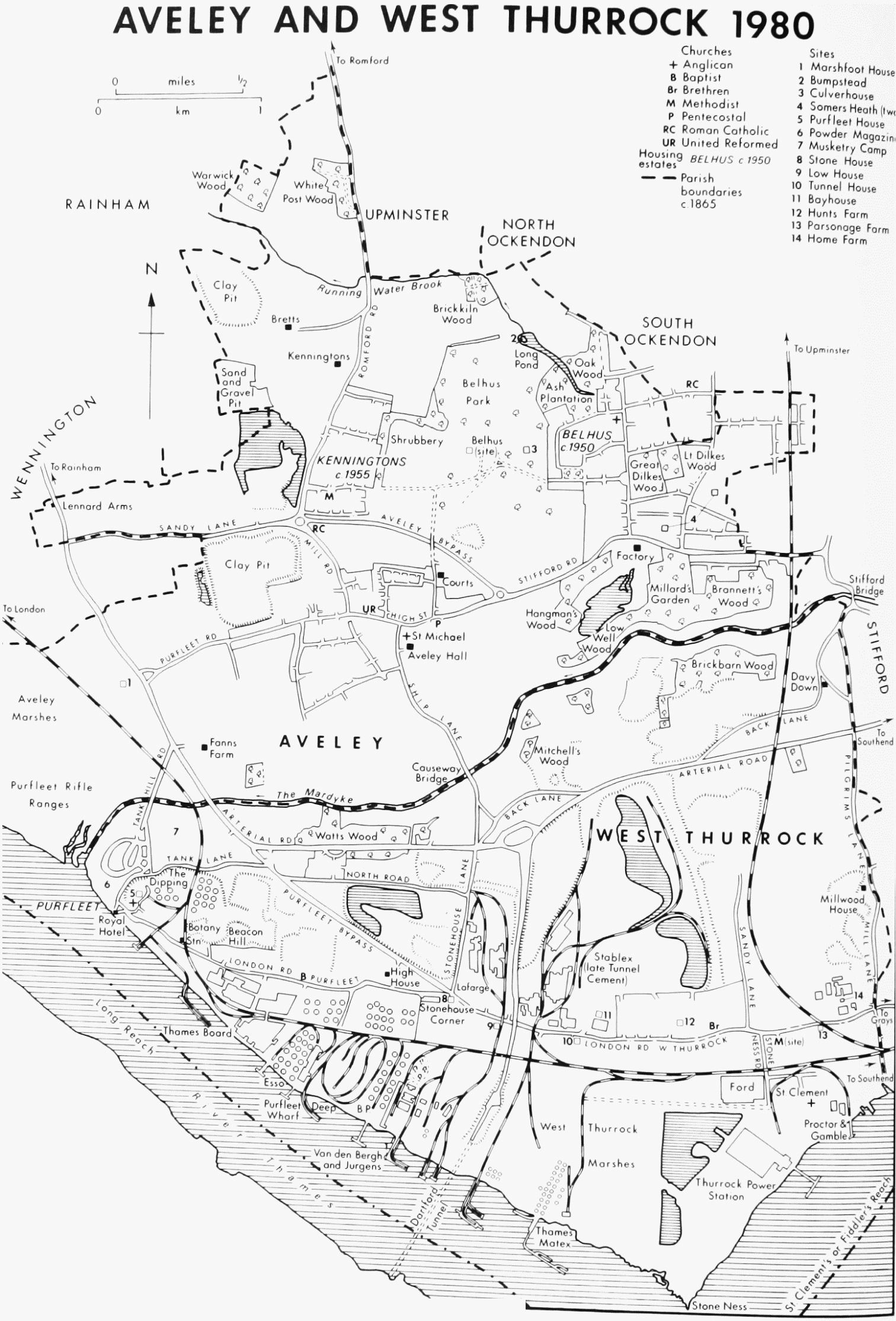
Aveley lies beside the Thames, 26 km. east of London and 6.5 km. north-west of Grays Thurrock. (fn. 1) The ancient parish comprised 2,695 a. (1,091 ha.). (fn. 2) It became part of Purfleet urban district in 1929 and of Thurrock urban district in 1936. From 1974 it formed the westernmost ward of the borough of Thurrock. (fn. 3) Part of Aveley is still rural, but in its north-east corner is the large Belhus housing estate built by the London county council.
The village stands on rising ground north of the river Mardyke, which flows south-west to join the Thames at Purfleet. West of Purfleet are Aveley marshes, bordering the Thames for 1.6 km. towards Wennington. North-west of the village the land rises to over 30 m. at Sandy Lane. The soil is mainly sand and gravel, with some clay and chalk. (fn. 4)
From the 11th century to the 17th Aveley was a large and flourishing village. The recorded population was 30 in 1066 and 33 in 1086. (fn. 5) Twenty-six Aveley men were assessed to the lay subsidy in 1327 and 73 in 1523; on both occasions those figures were exceeded, in Chafford hundred, only by Brentwood and South Weald. (fn. 6) In 1670 there were 84 houses in the parish; only Brentwood and Upminster had more. (fn. 7) During the next two centuries, however, growth was relatively slow, probably because the large area of parkland restricted building. In 1801, with a population of 543, Aveley ranked only sixth in the hundred, and by 1901, with 1,060, it had sunk to tenth. In 1931, the last year for which there are separate census figures, the population was 2,003. (fn. 8) After the Second World War the building of the Belhus estate brought a rapid increase. In 1961 the estate contained 22,212 inhabitants, mainly in Aveley. There were 5,897 in the rest of the ancient parish. (fn. 9)
AVELEY AND WEST THURROCK 1980
The remains of prehistoric elephants, found during gravel digging north of Sandy Lane, are displayed at the Natural History Museum, London. (fn. 10) In the same area have been found traces of Iron Age and Roman occupation up to the 5th century. (fn. 11) The medieval village grew up on the lower ground near the church, along the road (High Street) which continued east to Stifford and South Ockendon. West of the village, the main road ran north as Mill Road and Romford Road to Upminster and Romford. (fn. 12) Sandy Lane, which branches west from Mill Road towards Wennington, Rainham, and London, was the western end of an old road from Wennington to Stifford which bypassed the village. (fn. 13) In 1630 Lord Barrett obtained powers to close the eastern end, which ran along the southern boundary of Belhus park, and during the following years it was taken into the park. (fn. 14) Romford Road was known in 1359 and later as Bredle Street. (fn. 15) In the 18th century it was believed to have been a Roman road. (fn. 16) In 1713 Aveley and Upminster parishes agreed to share the cost of maintaining the part of it north of Running Water. A post marking the parish boundary presumably gave its name to the adjoining White Post wood. (fn. 17) Ship Lane, which runs south from the village to West Thurrock and Grays, crossing the Mardyke at Causeway bridge, was in existence by 1593. (fn. 18) Purfleet Road, which runs west from the village, was also known, in the 19th century and later, as Water Lane. (fn. 19) It existed in 1593 as a manor way leading to Fanns Farm, Marshfoot House, and Tunny Mead. (fn. 20) Gravel Pit Lane, which ran south from Sandy Lane to Water Lane, had fallen into disuse by 1809, when its closure was ordered. (fn. 21) By 1866 it was no more than a footpath. (fn. 22) In the 1760s, after the building of the gunpowder magazine at Purfleet, the Board of Ordnance made a new and more direct road from Purfleet alongside the marsh to Wennington and London. (fn. 23) That road, later called London Road, was lined with trees, fenced with posts and rails, and gated at each end. In 1827 the Board, no longer wishing to maintain the road, proposed to dedicate it to the public, in spite of opposition from Aveley and Wennington. (fn. 24) In 1925 London Road became part of the London-Southend arterial road, which crosses the Mardyke southeast of Fanns Farm. (fn. 25) The Aveley bypass, completed by 1969, runs east from the junction of Sandy Lane and Mill Road, to Stifford Road east of High Street. (fn. 26)
Causeway (Cauce, Cawsie) or Aveley bridge over the Mardyke, between Aveley and West Thurrock, was mentioned in 1364, when it was said to have been built by William Brinson in the reign of Edward II, to improve communication between his manors of Aveley and West Thurrock. (fn. 27) The bridge remained the joint responsibility of the lords of the two manors until 1664 or later, but by 1769 it had become a county bridge. (fn. 28) In 1760 it was said to be a wooden bridge. (fn. 29) It was rebuilt in brick in 1816, widened in 1844, replaced by a new iron bridge in 1862, and again rebuilt c. 1930. (fn. 30)
The medieval pattern of settlement changed little before the 20th century. In 1777 most of the houses were in High Street. (fn. 31) Aveley manor house, south-east of the church, had disappeared by 1593, and Bumpstead was demolished some time after 1719. (fn. 32) The principal building in the parish was Belhus, seat of the Barrett-Lennards, rebuilt by 1526 and emparked in the early 17th century. (fn. 33) It survived until 1957. Marshfoot House, at the west end of Water Lane, stood on the site of an earlier house. (fn. 34) From 1773 to 1787 it served as the workhouse for Aveley and Stifford. (fn. 35) It had disappeared by 1954. (fn. 36) Among other houses existing in 1777 were Pond Farm, probably named from a 14th-century family, and the Parsonage (later Parsonage Farm), both in Water Lane, Heath House, south-east of Belhus, Fanns Farm, near Marshfoot House, and Courts, north of the village. (fn. 37) Of those only Fanns Farm and Courts survive. In the early 19th century Aveley Hall was built south of the church, and a new Vicarage in Mill Road, on a site inclosed from the common. (fn. 38)
In the 14th century there was a ferry from Aveley across the Thames, and to London. It was last mentioned in 1374. (fn. 39) The use of the Mardyke for navigation is discussed below. (fn. 40) In the 1820s and 1830s Aveley was served by a daily coach between Horndon-on-the-Hill and London, and by various carriers. (fn. 41) The London, Tilbury, and Southend railway, opened in 1854 as far as Tilbury, passed through the south-west corner of Aveley, with a station at Purfleet, 3 km. from the village. The branch from Grays was opened as far as Upminster in 1892, with a station at South Ockendon, 3 km. north-east of Aveley village, and was extended to Romford in 1893. (fn. 42)
In 1876 Aveley was said to be a quiet agricultural village with a long street of small houses and cottages, some timber framed and plastered, with 'a decent inn, the Old Ship'. (fn. 43) That inn, recorded from 1754, still stands at the corner of High Street and Ship Lane. (fn. 44) An earlier inn on the site, the Swan, was mentioned in 1498, 1577, and 1618. (fn. 45) The Crown and Anchor, formerly the Cock, High Street, which also survives, is recorded from 1618. (fn. 46) Behind a late-18th- or early-19th-century front with parapet it has the plan and roof form of a late medieval hall and cross wing house. The Lennard Arms, London Road, was formerly the Crown and Cushion, first recorded in 1779. (fn. 47) It has an early 19th-century front with rear portions dating from the 16th and 17th centuries. The Harrow, mentioned in 1566, stood opposite the church in High Street. (fn. 48) It was demolished by 1850. (fn. 49) The Prince Albert, also in High Street, formerly in a 16th-century building, (fn. 50) had been demolished by 1954 and was later rebuilt. Many of the timber framed cottages remained until after the Second World War, but by 1954 only two or three survived. (fn. 51) Two old farmhouses remain in Aveley. Fanns Farm, east of London Road, stands on the site of a house recorded from 1339. (fn. 52) It was rebuilt in the mid 18th century, to a double pile plan, two storeys high, which has survived largely unaltered. (fn. 53) The farm buildings, although altered in the 19th century, retain the basic form of two identical stockyards with yellow brick ranges. (fn. 54) Courts, lying north of the village, was probably named from the le Curt family in the 13th century, and is recorded frequently from the 15th century. (fn. 55) It was a substantial medieval hall house, possibly moated, of which the service cross wing, screens passage, and one bay of the hall survive. A floor over the hall was inserted between 1593 and 1596. (fn. 56) The parts now missing had disappeared by the early 17th century, when extensions were made to the west and north of the cross wing. The village institute, in Mill Road, was formerly a Congregational church. The reservoir, also in Mill Road, was built in 1890 by the South Essex Waterworks Co. (fn. 57)
After the Second World War the London county council bought 1,220 a. of land in Aveley and South Ockendon to rehouse Londoners and to provide labour for the riverside factories at Purfleet and West Thurrock. The first house on the Belhus estate was occupied in 1950, and by 1959 there were 4,000 houses and 1,320 flats. Shops and a health centre were opened by 1955, and in 1963 a library in Derry Avenue and a community centre in Faymore Gardens. The Belhus estate was transferred to Thurrock borough council in 1980. Belhus park is used for sports, including golf, and has a swimming pool, opened in 1974. The Kenningtons estate, built by the L.C.C. on the western edge of Belhus park, was completed in the early 1960s. (fn. 58)
The Aveley Lunatick club, a social club formed in 1763, met at the Harrow on the first Monday after the full moon. Membership was 2s. 6d. and 1s. each meeting, with fines for late arrival and drunkenness. (fn. 59) In 1824 a social club held meetings at the Crown and Anchor. (fn. 60)
The Barrett and Barrett-Lennard families of Belhus had a long connexion with Aveley. Edward Barrett (1581–1644), Lord Barrett of Newburgh, was a diplomatist and Chancellor of the Exchequer. (fn. 61) Thomas Barrett-Lennard, Lord Dacre (1717–86), was an antiquarian who supplied Morant with much local material for his History of Essex. (fn. 62) Sir Thomas Barrett-Lennard, Bt. (1853–1923) was also an antiquarian. (fn. 63) The Cely family, prominent wool merchants, lived at Bretts in the 15th century. (fn. 64) Alice Diehl (1844– 1912), writer and musician, was born at Aveley. (fn. 65)
Manors and Other Estates.
There were five estates in 1086: three called Aveley and two called Kenningtons. (fn. 66) The estate of Odo, bishop of Bayeux, may have become the manor of Bumpstead. From William de Warenne's estate appears to have derived the manor of Kenningtons. Swein of Essex's estate in Kenningtons became the manor of Bretts, while that of John, son of Waleran, became Aveley manor. Ansger the cook held 50 a. in Aveley, together with 25 a. adjoining in Stifford. The descent of that tenement has not been traced.
The manor of AVELEY comprised most of the southern half of the parish. (fn. 67) It was held in 1066 by Sweyn, as 3½ hides. Another ½ hide, held by Ulsi, a free man, was later added by Waleran son of Ranulf, whose son John was holding the manor in demesne in 1086. (fn. 68)
The manor appears to have descended like that of Fyfield until the death of Stephen de Langton, which occurred in 1261. (fn. 69) Stephen's heir at Aveley was his kinsman William de Staundon, who was then under age and had died by 1272. (fn. 70) In 1286 Bartholomew Brinson (de Breaunzon, Brianzun) died holding the manor in right of his wife Joan. (fn. 71) Joan later married Sir John de Lovetot. She and Lovetot became closely associated with Walter Langton, treasurer of England and bishop of Lichfield, who was also rector of West Thurrock, and had custody of Joan's infant son William Brinson. (fn. 72) In 1303 Langton was acquitted of adultery with Joan, and of joining with her to murder Lovetot. (fn. 73) In 1305, after her death, William Brinson granted Langton a two year lease of the manor of Aveley, rent free, to pay off a loan made long before by Langton to Lovetot. (fn. 74) Brinson, who came of age c. 1305, died holding Aveley in 1310. (fn. 75) He was succeeded by his brother John (d. 1316) who left a son and heir (Sir) John Brinson (d. 1338). (fn. 76)
Sir John Brinson's posthumous daughter and heir Joan died in 1339. (fn. 77) She was succeeded by a kinsman, William, son of Swetman of Aveley, who in the same year sold the manor to Sir Thomas de Bradeston (d. 1360). (fn. 78) Sir Thomas's heir was his young grandson, Thomas de Bradeston. Thomas (d. 1374) left an infant daughter Elizabeth, who took the manor in marriage to Sir Walter de la Pole. (fn. 79) Sir Walter (d. 1434) was succeeded by his grandson (Sir) Edmund Inglethorpe, who by his will dated 1456 devised Aveley to his wife Joan. (fn. 80) Joan (d. 1494) left as coheirs a great-grandson, John Stonor, and four granddaughters. (fn. 81) Stonor appears to have succeeded her at Aveley, but had died by 1502, when his sister Anne and her husband Adrian Fortescue sold the manor to Averey Rawson, a London merchant. (fn. 82)
Rawson held Aveley in 1509. (fn. 83) Later, possibly in 1513 and certainly by 1519, it was acquired by the Savoy Hospital (Lond.). (fn. 84) When the hospital was dissolved in 1553 the manor was granted to the corporation of the City of London as governors of Christ's, Bridewell, and St. Thomas's Hospitals. (fn. 85) Aveley became part of the endowments of St. Thomas's Hospital. (fn. 86) In 1842 the manorial demesne comprised 732 a. (fn. 87) The land was sold in the 1920s, but the City retained the manorial rights. (fn. 88)
Aveley manor house stood on a moated site south-east of the church. In 1374 it was a substantial house with a deer park. It had disappeared by 1593. (fn. 89)
The free chapel of St. Anne or St. Mary, standing in the churchyard c. 180 m. NE. of the church, belonged to Aveley manor. (fn. 90) It was first recorded in 1316 and the last known chaplain was appointed in 1435. (fn. 91) In the 18th century and later it was known as Chapel de la Lee. (fn. 92) The remains of a wall, the last surviving part of the chapel, were demolished in 1947. (fn. 93) A meadow called Chapel Fen may have formed part of the endowment. (fn. 94)
The manor of BELHUS or NORTONS or MANYWARES or COPPINS CROUCH lay in the centre of the parish. The first three names came from 14th-century tenants. Coppins Crouch was the former cross-road at the southeast corner of Belhus park. In the later Middle Ages Belhus paid quitrent to the Knights Hospitallers' manor of Rainham. (fn. 95) The Hospitallers, who held Rainham from c. 1190, acquired land and rents in Aveley and Wennington during the 13th century from the Bret and Vaizey families. (fn. 96) In 1303 they held 1 knight's fee in Aveley. (fn. 97) Their property there seems to have included Belhus, Culverhouse, and several other tenements. (fn. 98) After the Dissolution Belhus paid quitrent to the manor of Purfleet, in West Thurrock, which also had been one of the Hospitallers' manors. (fn. 99)
The Belhus family, from whom the manor was named, came from Ramsden Bellhouse. (fn. 100) Nicholas Belhus probably settled at Aveley c. 1327. (fn. 101) His son Thomas married, before 1367, Elizabeth, daughter and heir of Richard Norton, whose estate, built up in the 1330s and 1340s, included lands bought from John Manyware. (fn. 102) Thomas Belhus, who acquired Bumpstead manor in 1375 but left it to Stratford Langthorne abbey, was dead by 1397, when Nortons was divided between his daughters Iseult, wife of Gilbert Lee, and Alice, wife of John Barrett. (fn. 103) Barrett was succeeded by his son Thomas (d. 1440) and then by his grandson Robert Barrett, who in 1458 bought the share of his cousin Walter Serjeant in Belhus or Nortons manor. (fn. 104) Robert Barrett, who was dead by 1483, was succeeded by his son John. (fn. 105)
Between 1483 and 1644 the Barretts built up around Belhus one of the largest estates in Essex. John Barrett, a notable lawyer, bought Noke manor in Wennington, and several farms in Aveley, including Culverhouse and Somers Heath. He also rebuilt Belhus House. (fn. 106) When he died in 1526 the estate comprised some 1,325 a. in Aveley and adjoining parishes. (fn. 107) He was succeeded by his grandson Edward Barrett (d. 1586), who inherited the manor of Bretts and bought that of Bumpstead. Edward was followed by a grandson, Edward Barrett (d. 1644), later Lord Barrett of Newburgh, sometimes called Lord Newburgh, who bought Kenningtons manor and Courts farm and made a park at Belhus. (fn. 108) In 1619 the estate comprised 2,249 a. (fn. 109) None of Lord Barrett's children survived, and he left the estate to his distant kinsman Richard Lennard, who took the name Barrett. (fn. 110)
Richard Barrett (d. 1696) was succeeded by his son Dacre Barrett (d. 1725). Dacre Barrett's heir was his grandson Thomas Barrett-Lennard, later Lord Dacre (d. 1786), (fn. 111) who devised Belhus to his natural son (Sir) Thomas Barrett-Lennard (Bt.). (d. 1857). The estate descended with the baronetcy. (fn. 112) During the 19th century several more farms were added to the estate, including Moor Hall, Rainham. (fn. 113) After the death of Sir Thomas, the second baronet, in 1919 his son Sir Thomas (d. 1923), moved to Norfolk, and during the following years the Belhus estate was broken up. In 1937 Essex county council bought 600 a. of it as part of the metropolitan Green Belt. (fn. 114) Much of the remainder was bought by London county council after the Second World War for a large housing estate. (fn. 115) In 1957 the L.C.C. sold 500 a. of Belhus park to E.C.C. to be added to the Green Belt. (fn. 116)
John Barrett (d. 1526) referred to Belhus in his will as 'newly builded'. (fn. 117) The house was of brick and ranged round a small courtyard with the north range extending eastwards. The hall formed the central section of the south side; the porch at the east end of the hall was surmounted by a four-storeyed tower. In the later 16th century a bay window was added to the south side of the hall, presumably at the time when a first floor was inserted. The 17th-century stables and outbuildings were mostly timber framed and lay to the east and south-east of the house.
In 1618 Sir Edward Barrett obtained a licence to make a park; he did this by adding Culverhouse (74 a.) and part of Bumpstead farm (36 a.) to the land surrounding Belhus (224 a.). (fn. 118) In the mid 17th century the park was stocked with 300 deer, and the gardens included a 'wilderness', 'rock garden' and a 'pallisadoe garden', which was presumably on the south side of the house where there was a walled forecourt. (fn. 119) The brick gatehouse forming the south entrance, and perhaps contemporary with the house, was demolished by Dacre Barrett between 1696 and 1710. (fn. 120)
Extensive alterations to the house, in Gothick style, and to the grounds, were made by Thomas Barrett-Lennard, later Lord Dacre, between 1744 and 1777. (fn. 121) The first phase of work (1745–6) included the building of a staircase block in the original courtyard, the recasing of the west wing as the entrance front with a hall in Gothick style, and the reconstruction of the south front, where the upstairs drawing room, with a coved ceiling, was formed above the original hall with a dining room on the ground floor. (fn. 122) The dining room was not fitted up until the second phase of alterations (1752–7); Sanderson Miller advised on this room, designing the chimney-piece in 1752. (fn. 123) James Lovell, carver, provided the decorative scheme for the north drawing room in 1754. (fn. 124) Lady Dacre's dressing room (Crest room) was fitted up in 1757. (fn. 125) The south-east block, with a tower corresponding to that at the west end of the south front, was added in 1776–7 to the designs of an architect named Watson (probably the mason, John Watson); during that period John Hobcraft received payments totalling £400. (fn. 126)
The walled gardens south of the house were probably removed in 1744. (fn. 127) The main work on the park began in 1749, when a start was made on the alteration of the stream to form the Long pond. Capability Brown worked at Belhus between 1752 and 1763, receiving a total of £668 14s.; he created the Shrubbery west of the house. (fn. 128) Richard Woods was employed between 1770 and 1771, and may well have been responsible for the final form of the Long pond, which was crossed by a bridge. (fn. 129)
Nineteenth-century alterations were largely confined to small additions to the service rooms on the east. During the Second World War Belhus was damaged by bombing and by military occupation; it was demolished in 1957. (fn. 130) The contents of the house had been dispersed in 1923. The important armorial glass, consisting of 15thcentury panels from Hurstmonceux Castle (Suss.), and 16th-century shields commemorating the alliances of the Barrett family, is in the Philadelphia Museum of Art, U.S.A.; the other 16th-century piece, a Tudor rose, is at King's College, Cambridge. (fn. 131) Lord Dacre had augmented the earlier armorial glass by commissioning shields, commemorating later family alliances, from William Peckitt. (fn. 132) The early Georgian canopied bedstead, formerly in the Queen's bedroom, is at Christchurch Mansion, Ipswich. (fn. 133) Fittings preserved at the demolition of Belhus in 1957 include an oak fireplace and panelling from the south drawing room, 5 crests from the ceiling of the Crest room, and the hall lantern, all at Thurrock Museum, and 16thcentury panelling and a firegrate, at Valence House, Dagenham. (fn. 134)
The manor of BRETTS or BRETTS PLACE lay in the north-west quarter of the parish. In 1066 Ulstan held I hide in Kenningtons. It passed at the Conquest to Swein of Essex, of whom it was held in 1086 by Lewin. (fn. 135) The overlordship descended as part of the honor of Rayleigh. (fn. 136)
The manor took its name from the Bret family, tenants in demesne in the 13th and early 14th centuries. Hugh le Bret held ¼ knight's fee in Kenningtons in 1212. (fn. 137) He or a namesake died in 1267 leaving John his son and heir. (fn. 138) John le Bret was succeeded in 1298 by his son Simon. (fn. 139) By that time the manor comprised 238 a., of which 104 a. were held of Rayleigh, 82 a. of the earl of Hereford, and 52 a. of Joan Brinson. The last two tenements had presumably been carved out of the neighbouring manors of Bumpstead and Aveley. Simon le Bret was still living c. 1308, but had died by 1323, when his son and heir Thomas came of age. (fn. 140) Thomas le Bret (d. 1329) left an infant daughter Elizabeth, who married Henry Baldwin. (fn. 141) In 1349 Elizabeth, then a widow, conveyed Bretts to John de Bolyngton (d. 1375). (fn. 142)
Joan, daughter and heir of John de Bolyngton, married William Sawtry. (fn. 143) In 1410 she and William conveyed Bretts Place to Robert Arnold. (fn. 144) In 1447 the manor passed to Richard Andrews, later dean of York, as cousin and heir of Robert Arnold's widow Isabel. (fn. 145) Andrews sold Bretts in 1462 to his brother-in-law Richard Cely (d. 1481 or 1482), a prominent London wool merchant. (fn. 146) Cely's son and heir, Richard (d. 1494), left three daughters and coheirs: Margaret, who married John Kettleby, Isabel, who married Robert Warham and later Anthony Cook, and Anne. (fn. 147) The manor was divided between the daughters, but Isabel eventually inherited her sisters' shares, and in 1531 she and her second husband sold the reversion of the whole to (Sir) John Baker (d. 1558), recorder of London and later Chancellor of the Exchequer. (fn. 148) Isabel Cook still had a life interest in Bretts in 1546, when Baker settled the remainder of the manor on his stepson Edward Barrett. (fn. 149) Bretts was in Barrett's hands by 1568, (fn. 150) and was thus merged in the Belhus estate.
Bretts manor house, known in 1349 and later as Bretts Place, stands on a moated site west of Romford Road. (fn. 151) It is of two storeys, with roughcast over timber framing and brick, and possibly dates from the 14th century. There are deep projecting wings, with a formerly open hall in the centre. The entrance doorway, probably of the 15th century but reset, has a four-centred head. Gothic windows were mentioned in the 18th century, (fn. 152) and traces of them were seen in 1954 behind the roughcast on the ground floor and inside the house. The upper floors are also known to have had some ancient windows of oak. The external appearance of the house is modern except for the doorway mentioned. (fn. 153) The moat survives on the north and east sides.
The manor of BUMPSTEAD lay in the north-east of the parish. It may have originated in the estate of 1 hide and 30 a. held in 1066 by Edward, a free man, and in 1086 by Mauger, tenant of Odo, Bishop of Bayeux. (fn. 154) In the 14th century Bumpstead was held of the Bohuns, earls of Hereford and Essex. (fn. 155) The Mandevilles, ancestors of the Bohuns, appear to have succeeded Odo of Bayeux in several other places where their manors adjoined his. (fn. 156) Since they held the large manor of South Ockendon they may well have acquired the overlordship of the adjoining manor of Bumpstead after Odo's forfeiture. (fn. 157)
The Bumpstead family, from whom the manor was named, were tenants in demesne in the 13th century. In 1286 Matthew, son of Gilbert of Bumpstead, granted to his son Geoffrey of Bumpstead the reversion to a messuage, a mill, and 176 a. land in Aveley. (fn. 158) Geoffrey of Bumpstead was holding ¼ knight's fee in Aveley in 1303. (fn. 159) He appears to have been succeeded by his cousin William of Bumpstead, who in 1319 was holding a messuage, a mill, and 208 a. (fn. 160) The manor descended with Ruckholt in Leyton until 1345, when William of Bumpstead was hanged for murder. (fn. 161) Both manors were restored to Joan of Bumpstead, William's widow, in the same year. (fn. 162) In 1349 Robert of Bumpstead, son of William, granted his Aveley estate to Henry of Ditton, who conveyed it to William of Chiddele, clothier of London. (fn. 163) Chiddele granted it in 1352 to Sir John of Staunton, lord of South Hall in Rainham. (fn. 164) In 1372 Sir John's son Ralph of Staunton vested Bumpstead, so named for the first time, in trustees from whom it was bought in 1375 by Thomas Belhus of Aveley. (fn. 165)
By Thomas Belhus's will Bumpstead, then comprising 208 a., and Brookland in Upminster, then 100 a., passed in 1400 to Stratford Langthorne abbey. (fn. 166) Brookland adjoined Bumpstead to the north, and may well have represented Odo of Bayeux's Domesday manor in Upminster. (fn. 167) It had been bought by Thomas Belhus in 1390, (fn. 168) and from that time was merged in Bumpstead manor. Stratford abbey retained Bumpstead until the Dissolution. In 1541 the manor was granted by the Crown to Edward North, later Lord North, who sold it in the same year to Edward Barrett. (fn. 169) Bumpstead was thus merged in the Belhus estate. In 1619 there was a 'fair mansion house' and 217 a. of land, (fn. 170) including 36 a. within the new park of Belhus. (fn. 171) The house, which was moated, was demolished by c. 1719. (fn. 172) Its site became the northern part of the Long pond in the park.
The tenement of CULVERHOUSE adjoined Belhus to the east. In the later Middle Ages it paid quitrents to the Knights Hospitallers, which suggests that its tenurial history was similar to that of Belhus. (fn. 173) The Culverhouse family, from whom the tenement was named, was living at Aveley in the 13th and 14th centuries. (fn. 174) Early in the 14th century John, son and heir of Richard Culverhouse (de Columbariis), granted to William Young of Wennington all his land in Aveley, except his wife's dower and a house in the market. (fn. 175) Thomas Young was holding Culverhouse in 1346. (fn. 176) It descended with the manor of Yonges in Wennington until 1406, when William Kelet and his wife Alice conveyed it, with 120 a. land, to Robert Arnold, who soon afterwards acquired also the manor of Bretts. (fn. 177) Culverhouse passed with Bretts to Arnold's widow Isabel, whose executors conveyed it in 1457 to William Spenser and his wife Isabel. (fn. 178) Isabel Spenser outlived three husbands. In 1484, as Isabel Atkinson, she conveyed Culverhouse to Henry Andrews, lord of Noke in Wennington. (fn. 179) Andrews left Culverhouse for life to his wife Christine (d. 1526) who later married William Carew. The reversion was sold in 1495 by Richard Andrews, son of Henry, to John Barrett. (fn. 180) Culverhouse thus became part of the Belhus estate. In 1619 it comprised 74 a. within Belhus park and 194 a. outside it. (fn. 181) Culverhouse farm house, which lay about 450 m. west of Belhus mansion, had disappeared by 1777. (fn. 182) Another dwelling, belonging to Culverhouse in 1619, lay about 1,200 m. south-west of Belhus. It then had no name, but was later called Somers Heath, a name originally applied to a tenement farther east. (fn. 183)
The manor of KENNINGTONS lay in the north-west quarter of the parish. In 1066 three free men held four hides in Kennington (Kelituna). William de Warenne (I) earl of Surrey, later obtained those tenements by exchange, and in 1086 they were all held of him by Wlbert. A further ½ hide, which in 1086 was held of Warenne by Ranulf, had belonged in 1066 to Ulwin, a free man. (fn. 184)
The descent of Warenne's manors, including those in Essex, is difficult to trace because so many of them were granted out to be held in socage and at fee farm. (fn. 185) In the 14th century and later the tenement or manor of Kenningtons was held in socage of Prittlewell priory, for an annual rent of 30s. (fn. 186) Lewes priory (Suss.), of which Prittlewell was a cell, was founded by William de Warenne (I), who endowed it with tithes from his demesne lands and rents from the other lands. (fn. 187) The rent from Kenningtons may have been originally granted to Lewes, and later assigned to Prittlewell.
The tenancy in demesne of Kenningtons appears to have been acquired soon after 1300 by Henry Garnet (d. 1345), as part of a large estate in Wennington, Aveley, and Rainham. (fn. 188) Kenningtons descended with the manor of Wennington until 1620, when it was bought from Sir William Ayloffe by Sir Edward Barrett, and was thus merged in the Belhus estate. (fn. 189) In 1620 Kenningtons comprised 212 a. (fn. 190) It passed with Belhus until 1937 when it was bought by Essex county council; the county council sold it in 1979 to J. P., W. D., J. F., and A. H. Davis. (fn. 191)
Kenningtons house is a timber framed building of two storeys. It was originally an aisled hall of much style, built between c. 1275 and c. 1310. The aisles seem to have been removed before c. 1380, when the building was extended one bay to the south. Later features include plain brick chimneys of 17th-century origin. The interior was modernized in the early 19th century. (fn. 192)
The tenement of SOMERS HEATH lay in the eastern half of the parish, extending into Stifford. In 1526 it was paying quitrent to St. Bartholomew's hospital, (fn. 193) which indicates that it was part of the land of Kenningtons granted to the hospital between c. 1193 and 1212 by Gilbert de Tham'. (fn. 194)
The Somer family, from whom the tenement was named, were living in Aveley by 1327. (fn. 195) In 1342 Roger Ynge of Aveley granted to Thomas Somer and his wife Joan and their daughter Agnes 4 dayworks of land and a house, with remainder to Thomas's sons Thomas and John. (fn. 196) This may have been Somers Heath, which, so named, was certainly in the hands of the Somer family by 1464. (fn. 197) They continued to hold it until 1514, when the widow and daughters of John Somer sold it, with about 90 a. of land, to John Barrett. (fn. 198) Somers Heath was thus merged in the Belhus estate. In 1619 it comprised 144 a. in Aveley and Stifford. (fn. 199) The house, which lay about 100 yd. west of the Stifford boundary, had disappeared by 1778, its name having been transferred to a house farther west which had previously been part of Culverhouse. (fn. 200)
Economic History.
Aveley has long been an area of mixed farming evenly balanced between arable and pasture. Between 1066 and 1086 the total number of ploughteams, indicating arable, declined from 12½ to 8½, while the number of sheep recorded rose from 20 to 80. Those changes took place mainly on Kenningtons manor, held by William de Warenne, where the number of ploughteams fell from 4 to 2, while sheep rose from 20 to 50. The value of Kenningtons had risen from 30s., when Warenne received it, to 97s. in 1086. In 1066 there had been 1 villein and 4 serfs on the manor, but by 1086 there were 7 villeins, 1 bordar and 1 serf. On Aveley manor, held by John, son of Waleran, the number of ploughteams had decreased between 1066 and 1086 from 5½ to 3, but although there were 60 a. of meadow, no livestock was recorded, and both the value and the population had fallen. No significant changes occurred in the two smaller manors. (fn. 201)
Numerous conveyances, in the 13th and 14th centuries, of 1–a. pieces of land, suggest the practice of open-field farming then or previously. (fn. 202) The existence of common pastures, or leazes, at some early period is indicated by field names. In 1593 Great and Little Horse Leighs comprised about 10 a. in Aveley marsh, and in 1619 Sheepsleaze and Nightleaze formed part of Belhus park. (fn. 203) There were about 15 a. of common waste west of Mill Lane, which in 1593 was called Gallowsheath. (fn. 204) By 1837 the vicarage house occupied 1 a. of that land, and in 1845 St. Thomas's hospital, lord of Aveley manor, sold about 8 a. of it to the vicar as glebe. (fn. 205)
In 1086 the manor of Kenningtons had woodland for 100 swine. (fn. 206) In 1619 most of the woodland in the parish, some 307 a., belonged to the Belhus estate. (fn. 207) The timber in the woods was reserved, and the herbage let for grazing. (fn. 208) In 1907 the woods at Belhus covered almost exactly the same area as in 1619. (fn. 209) After 1949 the woods were preserved for recreation. (fn. 210)
Aveley marshes are described below. They were used for arable as well as for pasture. In 1287 there were 95 a. arable in the marshes, but the pasture could not be measured as it was flooded. (fn. 211) In 1861, when the total area of the marshes was 470 a., only 23 a. were arable. (fn. 212) Between 1640 and 1645 the rateable value of marshland was twice as high as that of upland. (fn. 213) There was much pasture elsewhere in the parish. Bretts contained 200 a. of pasture in 1567. (fn. 214) In 1619 the Belhus estate contained 1,020 a. of meadow and pasture, of which 306 a. were in the newly formed park. (fn. 215)
The growth of the Belhus estate in the 16th and early 17th centuries was an important feature of Aveley's economy. (fn. 216) By 1619 the estate comprised 2,249 a., of which 2,034 a. were in Aveley, occupying nearly 70 per cent of the total area of the parish. (fn. 217) In the 19th century several more farms were added, but the estate was broken up after the First World War.
In 1842 the parish contained 1,636 a. arable, 949 a. pasture and 162 a. woodland. (fn. 218) Returns in 1906 list 1,302 a. as arable and 1,160 a. as permanent grass, and in 1926 there were 1,231 a. arable and 481 a. grass. (fn. 219) The decline in the area under grass may be partly accounted for by the opening, by 1910, of Purfleet rifle range on Aveley marshes. (fn. 220) In 1944 the London county council was authorized to develop 1,220 a. of land for housing in Aveley and South Ockendon, of which half was arable and half pasture. (fn. 221)
In 1813 there were over 500 Southdown sheep at Belhus. (fn. 222) Returns for the parish in 1866 list 896 sheep, 58 cattle, and 159 pigs. (fn. 223) By 1926 sheep had declined to 150 and pigs to 49, but cattle had increased to 272. (fn. 224) Bretts farm, when put up for sale in 1951, contained a herd of 45 Friesian dairy cows and heifers, and 44 swine. (fn. 225) In the 1870s and 1880s the Belhus stud was notable, and held annual sales of hunters: the sale of 1882 realized 6,230 guineas. (fn. 226)
The light, sandy soil, with gravel subsoil, was suitable for vegetable growing. By 1795 potatoes were being grown for horse fodder, and early peas for the London market, for which Aveley became notable. (fn. 227) In 1841 the census included 113 migrant Irish labourers who, as at Stifford, were probably pea-pickers. (fn. 228) One Aveley farmer, Isaac Knight, was known in the 1880s as the 'marrow king'. (fn. 229) Returns in 1866 list 521 a. of vegetables, mainly potatoes, peas, turnips, and swedes, and 764 a. of cereals, mainly wheat and barley. In 1906 the area of vegetables returned had risen to 669 a., while that of cereals had fallen to 384 a. In 1926 vegetables were returned on 567 a. and cereals on 470 a. (fn. 230) In 1842 there were 5 farms of more than 50 a., the largest being Manor Farm, belonging to St. Thomas's hospital, with 732 a., and 8 holdings of between 20 a. and 50 a. (fn. 231) In 1926 there were 7 farms of more than 50 a., including 2 with over 300 a., and 2 holdings between 20 a. and 50 a. (fn. 232)
There was a water mill on Aveley manor in 1286. (fn. 233) In 1316 it was ruinous and in danger of falling down. (fn. 234) Both in 1360 and 1374 it was said to be worthless because of flooding and the lack of millstones. (fn. 235) Bumpstead manor had a windmill in 1286, 1349, and 1352. (fn. 236) The site was drowned when the Long pond was created in Belhus park c. 1761. (fn. 237) Aveley windmill, recorded from 1619, stood east of the road to Romford, opposite Gallowsheath common. (fn. 238) Being near Kenningtons, it may have been identical with the mill of Kenningtons, mentioned c. 1260. (fn. 239) The last miller was recorded in 1848, but a postmill was standing until c. 1930. (fn. 240)
A weekly market, on Monday, was granted in 1248 to Stephen de Langton, lord of Aveley manor. (fn. 241) It became one of the busiest markets in the district. Before the end of the 13th century it was attracting fullers and other merchants from Kent, (fn. 242) and it was often mentioned in the 14th century. (fn. 243) In the 16th century rents were paid for 12 stalls and 2 standings; the main products for sale were butter and cheese. (fn. 244) The topography of High Street suggests that the original market place was there. (fn. 245) In 1372 two men were charged with building shops on the highway in the market place. (fn. 246) A map of 1593 shows the 'butter market' south of High Street in the present Ship Lane. (fn. 247) The market appears to have survived at least until the 1680s, but had ceased before 1768. (fn. 248)
An annual fair, for three days at Michaelmas, was granted to Bartholomew Brinson, lord of Aveley manor, in 1286. (fn. 249) There was still a fair on the manor in 1339, but no more is known of it. (fn. 250) In 1762 quarter sessions ordered the suppression of an unlawful fair at Aveley, apparently of recent origin. (fn. 251) The order may have been ineffective, for an Easter fair was being held in 1810, when soldiers were involved in a riot there. (fn. 252) The Easter fair was last recorded in 1863. (fn. 253)
The main industries have been concerned with the extraction of gravel, chalk, and clay. Brickmaking was carried on in the north of the parish near the Upminster boundary. In 1619 there were brickfields in Belhus park. (fn. 254) A brickmaker, Mrs. Perry, was mentioned in 1736. (fn. 255) Brickkiln wood, field, and mead and Brickclamps field were named in 1842. (fn. 256) Chalk quarrying, mentioned in 1768, when chalk was said to be widely used as manure, probably took place near the Mardyke, in Chalk pit field. (fn. 257) There was a gravel pit in Gallowsheath common in 1593. (fn. 258) Gravel digging was carried out by Hall & Co. in Sandy Lane from 1947. (fn. 259) In 1979 the pits were being reclaimed.
The Marley Tile (Aveley) Co. Ltd. opened a factory in Stifford Road in 1937, making cement tiles. (fn. 260) From 1970 London clay from Aveley was pumped as slurry to West Thurrock, to make cement. (fn. 261) The Aveley trading estate, built after the Second World War, includes, on its South Ockendon site, two factories in Arcany Road and Ardmore Road, each divided into several small units. (fn. 262) By 1962 all the units were occupied and were being used for garment manufacture, electrical engineering, and other light industries. (fn. 263) Aveley Electric Ltd., Arisdaile Avenue, manufacturers of toroidal components, employed over 200 people by 1968. (fn. 264)
Marshes and Sea Defences.
Aveley's coastline with the Thames is only 1,500 m. long, but its marshes were more extensive than that suggests. As late as 1760 the river Mardyke was tidal for about 8 km., and was subject to flooding, especially when the drainage was neglected. (fn. 265) About 1 km. from the mouth of the Mardyke was a tract of land called the fens, from which Fen (or Fanns) farm was named: when first mentioned, in 1339, it was flooded, and could not be measured. (fn. 266) There are other references to floods at Aveley in 1287, 1452, and 1560. (fn. 267) Commissioners of sewers for Aveley and district are recorded in 1321, 1391, 1449, and 1509. (fn. 268)
By the later 16th century the marshes were governed by a court of sewers whose jurisdiction extended from West Ham to Mucking. (fn. 269) Aveley level, which formed part of that area, in 1563 ran from Rainham bridge to Grays bridge. (fn. 270) The marshland in Aveley parish then comprised 314 a., of which 274 a. lay in Aveley marsh, and 40 a. in Tonney mead. Tonney (later Tenny) mead, which was probably identical with the medieval Toumannesmead (Townsmens' mead) lay beside the Mardyke near Fen farm. (fn. 271) Aveley marsh was shared between two owners, of whom St. Thomas's hospital, London, lord of Aveley manor, held the greater part. St. Thomas's was also one of six owners in Tonney mead. At Aveley, as elsewhere, the owners were responsible for maintaining the sea walls: 488½ rods (2,463 m.) in Aveley marsh and 113 rods (567 m.) in Tonney mead. (fn. 272)
About 1680 Aveley level was combined with Mucking level to form Rainham level. (fn. 273) In 1760, when the government was planning the powder magazine at Purfleet, an engineer reported that the Mardyke was very badly drained, mainly because the water mill at its mouth penned in the tides for 6 hours in 24. (fn. 274) The mill was demolished in the following year. (fn. 275) In the 19th century Aveley and West Thurrock formed a division of Rainham level. In 1838 Aveley's marshes, then reckoned to include the meadows by the Mardyke, comprised 501 a., with 6 owners. (fn. 276) By 1861 they had been reduced to about 470 a. (fn. 277) In 1931 Rainham level passed to the Essex Rivers catchment board, which in 1952 was merged in the Essex River board. (fn. 278) One of Aveley's worst floods occurred in 1888, when over 400 a. of Aveley Hall farm were affected. (fn. 279) In the 1953 floods, when Purfleet suffered much, there was no serious damage at Aveley.
Local Government.
In 1273–4 Aveley manor claimed the rights of gallows, assize of bread and of ale, and warren. (fn. 280) View of frankpledge was first recorded in 1316. (fn. 281) Rolls and extracts exist for courts leet between 1519 and 1686, and for courts baron from 1519 to 1934. (fn. 282) In the 16th and early 17th centuries the courts were usually held once a year, and in the early 17th century were said to be kept with great care. (fn. 283) There was usually one constable, except from 1532 to 1547 when there were two. From 1559 to 1662 two headboroughs were appointed. There were two aletasters from 1519 to 1686 and a poundkeeper was recorded in 1659, 1676, and 1686. In 1587 a pillory and ducking stool were said to be required. In 1624 and 1628 a ducking stool, whipping post, and common pound were all lacking, while the pillory needed repair.
Rolls or extracts for courts leet and baron for Belhus manor exist from 1482 to 1613. The manor had view of frankpledge and rights of waifs and strays and felons' goods. The court was usually held on hockday, the second Tuesday after Easter. A constable was appointed in 1555 and again in 1591–3. A prison was mentioned in 1484 and 1498. (fn. 284)
In 1373 the view of frankpledge for Bretts manor was held by the honor of Rayleigh. (fn. 285) In the 16th century, after Bretts and Bumpstead had been merged in the Belhus estate, a joint court was held for the three manors. (fn. 286) The last court was held in the time of Lord Newburgh (d. 1644), after which the owners appear to have found the manorial dues too small to be worth collecting. (fn. 287)
The parish records include vestry minutes (1640–1704, 1706–1852); churchwardens' rates (1785–9), accounts (1760–96), and bills (1751– 1878); constables' accounts (1705), rate (1729), and papers (1718–1863); overseers' rates (1640–5, 1797–1827), accounts (1691–1836), bills (1700–1845), and apprenticeship papers (1685–1847); and surveyors accounts (1810–26). (fn. 288)
From 1640 to 1704 only one vestry was recorded each year, usually at Easter. From 1706 to 1766 two or three annual meetings were recorded. In 1708 the vestry ordered quarterly meetings of all paying scot and lot, to consider the state of the poor, with 1s. fine for non-attendance. From 1767 to 1834 only the Easter vestry was recorded in the minutes, but monthly meetings were held from 1800, and probably before, since in 1776 the vestry ordered that no more than 10s. was to be allowed for expenses at each monthly meeting. Between 1640 and 1704 the vestry minutes were rarely signed. From 1706 to 1835 there were usually between 4 and 8 signatures. From 1706 to 1770 the vicar or curate attended regularly and signed first. After 1770 his attendance was irregular, and the churchwardens signed first. Vestry meetings were held in the vestry room of the church, but sometimes adjourned, as in 1801 to the Ship inn, and in 1802, 1806, and 1821–4 to the Crown and Anchor. A church clerk was appointed in 1685 and 1708. In 1723 his salary was £2 10s., supplemented in 1747 by 5s. for washing surplices. In 1795 he was allowed an assistant and his salary was increased to £6 a year. A select vestry, with 10 ordinary and 2 honorary members, was appointed in 1821. It existed in 1822 but there is no later reference to it.
There were two churchwardens from 1640 to 1708, one only from 1709 to 1812, and two again from 1812. In 1746 and 1754 the warden was nominated by the vicar. From 1828 one was nominated by the parish, the other by the vicar. There were two overseers of the poor until 1722, one only from 1723 and two again after 1772. An assistant overseer was appointed from 1826 to 1829 at a salary of £20. In 1832 the overseer was allowed a rate collector at a salary of £10. There were usually two surveyors of the highways; in 1716, 1742, 1752, and 1754 members of the Barrett family of Belhus held the office. A headborough was nominated in 1648, 1650, and 1652. There were two constables from 1640 to 1726, usually one only from 1726 to 1789, and two again after 1789. A beadle was appointed in 1812. Separate rates were levied in the late 17th and early 18th centuries but after 1743 the constables' debts were settled by the overseers.
Poor relief was given in the form of cash doles, payments for clothing, and burial. Poor children were apprenticed, as farmworkers or shoemakers, usually within the parish, but on two occasions in Kent, as wheelwright in Plumstead in 1803 and as printer and bookbinder in Deptford in 1822. In 1720 badges were ordered for the poor. (fn. 289) In 1735 and 1736 the vestry ordered strict measures to be taken against unlawful inhabitants, and in 1768 ten parishioners were ordered to be indicted for taking in lodgers. In 1797 an agreement was made with Rainham and Wennington for joint action against gypsies and vagrants. In 1773 Marshfoot House was leased as a workhouse for 14 years at £6 yearly. Aveley and Stifford used it jointly from 1774 to 1787 when the contents of the house were sold. (fn. 290) From 1787 to 1792 Aveley used the workhouse at Great Warley, paying £3 3s. in rent and allowing 2s. 6d. per week for each inmate. There were 10 inmates from Aveley in 1787 but the average number was 4 or 5. From 1792 to 1802 Aveley, West Thurrock, and Stifford jointly used the West Thurrock workhouse, sharing expenses equally. From 1806 Aveley, West Thurrock, and Rainham leased Noke House, Wennington, as a joint workhouse. (fn. 291) An agreement made in 1810 and renewed in 1813 gave the master of the workhouse a salary of £40 yearly, plus coal and extra allowances for maternity and burials. A sum of 4s. was allowed weekly for each pauper, to be increased to 5s. when bread exceeded 1s. 6d. a loaf. West Thurrock withdrew from the agreement in 1831 and the contents of the workhouse were sold. Medical care for the poor was provided casually in the early 18th century, but by 1772 a doctor was being retained at £2 a year, rising to £10 by 1803, with additional payments for fractures and midwifery. The rate was increased to £15 in 1817 but was reduced in 1821 to £13 because of the 'pressure of the times'. Inoculation was introduced in 1809.
Rates levied for the relief of the poor from 1640 to 1645 were assessed not only on land but also on the 'abilities' of the inhabitants. (fn. 292) In the early 18th century the rates were usually levied twice yearly, but by the end of the century six or seven times. From Easter 1817 to Easter 1818 a monthly rate of 6d. was levied. From 1640 to 1645 average annual expenditure on the poor was £28. In 1776 it was £196, while in the years 1783 to 1785 it averaged £136. Between 1800 and 1816 the average expenditure was £277, an increase, compared with 1783–5, similar in proportion to those in most of the neighbouring parishes, except Rainham and Cranham, where it was much higher. (fn. 293) In Aveley the worst years were 1810 and 1816, when the parish paid out £407 and £419 respectively. (fn. 294) In 1835 Aveley became part of the Orsett poor-law union.
Aveley remained part of Orsett rural district until 1929, when it was joined to West Thurrock and South Ockendon to form Purfleet urban district, later becoming part successively of Thurrock U.D., and of Thurrock borough. (fn. 295)
Churches.
Aveley church dates from the 12th century. The advowson was held by the lords of Aveley manor until 1314, when John Brinson granted it to Lesnes abbey (Kent). (fn. 296) The abbey was immediately licensed to appropriate the rectory, but did not at first do so, and between 1314 and 1330 presented at least four successive rectors, who in turn presented to the vicarage. (fn. 297) By 1323 the bishop had assigned a portion to the vicar, but the arrangement may have caused dissension, for in the same year the newly appointed rector, William Lapryn, was assaulted and robbed at Aveley by a gang of local men. (fn. 298) A vicarage was formally ordained in 1330 by the bishop of London. The vicar was to receive all oblations and small tithes, and the abbey was to provide him with a house. (fn. 299) In return the vicar was to pay the abbey an annual pension of £5, and was to maintain the chancel of the parish church. The bishop reserved the advowson of the vicarage for himself and his successors, and stipulated that Lesnes should pay 10 marks a year to the dean and chapter of St. Paul's. No rector was instituted after 1330. Since then the advowson of the vicarage has been held by the bishop of the diocese. The rectory remained with Lesnes until the dissolution of the abbey in 1525. With other Essex property, including the advowson of Rainham, it was granted in 1526 to Wolsey, who settled it on Cardinal College, Oxford. (fn. 300) On Wolsey's fall it reverted to the Crown, and in 1536 was granted to the dean and chapter of St. Paul's. (fn. 301) It remained with St. Paul's until the later 19th century, when it was transferred to the Ecclesiastical (later Church) Commissioners. (fn. 302) From the 16th century onwards the rectory was often leased. (fn. 303)
The rectory was valued at 40 marks in 1254, £30 in 1291, and £60 in 1650. (fn. 304) The great tithes were commuted in 1842 for £461; there were then 30 a. of rectorial glebe. (fn. 305) The rectory was charged with a rent which originated between 1069 and 1076, when Waleran son of Ranulf, lord of Aveley manor, granted his tithes to the abbey of St. Stephen, Caen (Calvados, France). (fn. 306) In 1254 Panfield priory, a cell of Caen, was receiving 30s. a year in place of 2 sheaves from the demesne of the lord of the manor. (fn. 307) By 1291 the rent to Panfield had risen to £2. (fn. 308) When the alien priories were dissolved in 1414 the rent passed to the Crown. (fn. 309) Henry VI granted it in 1441 to Eton College. (fn. 310) The rectory house, to which there are references from the late 13th century, was later known as Parsonage Farm. (fn. 311) It stood on the north side of Purfleet Road, near the present Lowlands Road.
The vicarage was valued at £14 10s. 4d. in 1535 and £54 in 1650. (fn. 312) Between 1650 and 1653 it was receiving an augmentation of £20 a year, but that had lapsed by 1659. (fn. 313) In 1690 the vicar temporarily surrendered his rights to tithes and other dues on condition that the parish vestry paid half his taxes and hired a curate at £28 a year. (fn. 314) In 1842 the small tithes were permanently commuted for £330. (fn. 315) The vicar had a house at Aveley in 1384. (fn. 316) The deeds relating to it, from 1325 to 1392, appear to have come from the archives of Lesnes abbey, (fn. 317) which suggests that the abbey may have been concerned in providing the house, as directed in the ordination of 1330. In 1650 there was no Vicarage house or glebe, and in 1685 it was said that neither had existed within living memory. (fn. 318) In the earlier 18th century the vicar lived at Hornchurch. (fn. 319) R. Marsh White, vicar 1833–63, bought an acre of land in Mill Road, and by 1837 had built a Vicarage there. (fn. 320) In 1845 he bought a further 8 a. adjoining. (fn. 321) The Vicarage, with most of the land, was sold in 1922, when a new house was built. (fn. 322)
The earliest known rectors were both foreigners, William de Friscobaldis was presented in 1311 by the king when the manor was in his hands after the death of William Brinson. (fn. 323) Jordan Moraundi was already rector in 1317, when he received papal provision elsewhere. (fn. 324) For the vicars, before the 18th century, Aveley cannot have been an attractive living, since they rarely stayed long. Between 1327 and 1706 no fewer than 58 are recorded, compared with 30 rectors of the adjoining parish of Stifford in the same period. (fn. 325) William Taylor, vicar 1574–89, and his successor Thomas Austen, 1589–1609, both quarrelled with their parishioners. (fn. 326) Austen, when leaving, was sternly admonished by the bishop for his 'unpeaceable spirit', but Aveley must have been a difficult parish at that period, for in 1628 there was another quarrel, involving an assistant curate. (fn. 327) William Ayscough, vicar 1641–52, was evidently a Puritan. (fn. 328) He had at least one successor before the Restoration. (fn. 329) Duel Pead, instituted in 1712, remained until 1767, and also served as assistant curate of Wennington and West Thurrock. (fn. 330) George Pattrick, vicar 1772–1800, and also curate of Wennington, obtained the living through the influence of Lord Dacre, whom he helped with historical research; in his later years he was a popular preacher in London. (fn. 331) Between 1800 and 1833, under three absent vicars, the parish was served by curates. (fn. 332) R. Marsh White, vicar 1833–63, built the village school as well as the Vicarage. (fn. 333)
The church of ST. MICHAEL, in High Street, is of flint and ragstone with some Roman and 16th-century brick; the tower is of limestone. (fn. 334) It has a chancel with north chapel, aisled and clerestoried nave with north porch, and west tower. The nave was built early in the 12th century and retains some fragments of the original walls. The south aisle, with its arcade of three bays, was added later in the 12th century, and the north aisle early in the 13th century. Later in the 13th century the chancel was rebuilt, presumably replacing a smaller structure of the 12th century or earlier, and the tower and north chapel were added. During the 14th century the south aisle was remodelled and given a new doorway and windows. Most of the other windows in the church were replaced in the 15th century. During that century also the north porch was added and the north aisle was extended alongside the tower, which was given a new west doorway and windows. The clerestory and a new nave roof were built in the 16th century. A lofty spire, blown down in 1703, was replaced before 1769 by a shorter one. (fn. 335)
Major repairs were carried out in 1830, to prevent the church falling down. The chancel was restored in 1885 by the Ecclesiastical Commissioners, as impropriators. (fn. 336) In 1888 the remainder of the church was renovated and the tower arch was opened by the removal of the west gallery. (fn. 337) The tower was restored in 1910 and the roof in 1934. (fn. 338) A further restoration was carried out between 1947 and 1955. (fn. 339) The tower was renovated in 1973.
There are three bells: one of between c. 1508 and c. 1522, the others dated 1618 and 1692. (fn. 340) Two bells of 1712 were sold in 1979, when the remaining bells were rehung. The plate includes a silver cup and paten of 1620. (fn. 341) The font is of the late 12th century. The oak chancel screen dates from the 15th century. The pulpit, with hexagonal sounding board, is dated 1621. There is a carved armchair of the same period. (fn. 342) The iron lectern was purchased in 1888 from Winchester Cathedral. (fn. 343) The most notable monument is a military brass to Ralph de Knevynton (d. 1370). (fn. 344) The Barretts of Belhus and their successors the Barrett-Lennards are commemorated by many monuments from the 16th to the 20th century, including an armorial tablet to Thomas BarrettLennard, Lord Dacre (d. 1786).
The manorial chapel of La Lee is treated elsewhere. (fn. 345) The church of ALL SAINTS, Belhus Park, Foyle Drive, originated in 1952 as a mission on the L.C.C. estate. A church was opened in 1953 and a conventional district was formed in 1955. (fn. 346) A new parish, taken out of Aveley, South Ockendon, and Stifford, was formed in 1958, the advowson of the vicarage being vested in the bishop. (fn. 347)
Roman Catholicism.
The Aveley, formed in 1952, included Aveley village and the L.C.C. estate in Aveley and South Ockendon. The Parish church of the Holy Cross, Eastington Way, South Ockendon, was completed in 1961. (fn. 348) The church of ST. PAUL, 1964, was in 1979 still being served from Holy Cross. (fn. 349)
Protestant Nonconformity.
The house of Thomas Jordan in Peter's Court was registered in 1712 for Presbyterian worship by Robert Browne, minister. (fn. 350) A General Baptist church centered at Pilgrims Hatch, South Weald, in 1715, was said to have a meeting place at Aveley. (fn. 351) In 1749 Francis England of West Thurrock by his will left £25 to a meeting place of Protestant dissenters at Aveley. (fn. 352)
Aveley United Reformed church, High Street, probably originated in 1815, when Anthony Brown, minister at South Ockendon, registered a building for Calvinistic worship. (fn. 353) In 1817 a church and school were built on a leasehold site in Mill Road. (fn. 354) Brown claimed attendances of 150 to 200 in 1829. (fn. 355) He and his successor at South Ockendon superintended the chapel until 1856, after which the pulpit was supplied by Hackney College students until 1863, when Robert Clarke (1796–1878) became the first resident pastor. (fn. 356) When the lease expired in 1877 a new church was built in High Street, on a site given by Sir Thomas Barrett-Lennard Bt. (fn. 357) The old building continued in use as an institute. (fn. 358) From 1879 to 1909 Aveley was supplied by students from New College, London. The congregation was small, with only 23 members in 1880. As the district grew the numbers rose to over 50 in the 1930s and to a peak of 70 in the early 1950s. (fn. 359) In 1972 Aveley joined the United Reformed church. There were 25 members in 1979. (fn. 360)
Methodism was brought to Aveley by John Valton in the 1760s, but did not take root. (fn. 361) In 1844 William Jones, a Primitive Methodist missionary, registered a meeting place at Aveley. (fn. 362) The building, which later became a coal shed, (fn. 363) was probably included in the Brentwood mission circuit formed in the following year. Aveley P.M. church, registered in 1851, was head of a circuit from 1851 to 1855, but closed soon after. A daughter church at Grays thrived and founded its own circuit. (fn. 364) Shannon Way Methodist church, on the L.C.C. estate, was registered in 1958, and its permanent building in 1961. (fn. 365)
Aveley Pentecostal church, Aveley Close, was registered by the Assemblies of God in 1967. (fn. 366) In 1979 it occupied the buildings of the former National school.
Education.
There are references to a schoolmaster at Aveley in 1340, (fn. 367) to unlincensed teaching c. 1598, (fn. 368) and to two schoolmasters in 1602 who may have been rivals. (fn. 369) In 1807 there were three day schools, with a total of 33 girls, and another with 30 days; all the pupils paid 6d. a week. (fn. 370) In 1839 there were a 'middle' school, an Independent Sunday school, and several dame schools, besides the Anglican schools mentioned below. (fn. 371) A nonconformist girls school, which existed in 1871, seems to have closed by 1893. (fn. 372)
Averley county junior and infant schools, Stifford Road, originated in 1812, when a Church Sunday school was founded, supported by subscription. (fn. 373) By 1816 it was a day and Sunday school for 174. (fn. 374) An infant school was started c. 1837, supported by the vicar and Lady BarrettLennard. By 1839 there were two Church day and Sunday schools. They had no school room (fn. 375) and seem to have been merged in 1844 when a National school for 75 was built by subscription and grants from the government and National Society, on land beside the church given by the governors of St. Thomas's hospital. (fn. 376) It received annual government grants from 1858. In 1852, when there were 130 children on the register, an infant classroom was added. (fn. 377) In 1858 most of the day pupils were infants; evening classes were also held from 1846 to 1881. (fn. 378) In 1871 the school was enlarged, and in 1886 a new school for 100 infants was built. (fn. 379)
In 1907 the county council took over the Church infant school, for which new buildings for 120 were erected in 1909 behind the National school. (fn. 380) The National school itself was taken over by the council in 1913. A new council school for 240 was built in 1914 next to the old one, but both new schools were used as a military hospital until at least 1916, while children were taught at the old school and the Aveley Institute. The old school was used again in the 1930s and 1940s to relieve overcrowding. (fn. 381) In 1939 the seniors were transferred to Aveley senior council school. The junior and infant schools were amalgamated in 1943, but were separated in 1950 when a new junior school was opened on an adjoining site. (fn. 382)
Aveley school, Nethan Drive, originated in 1939, when a senior council school was opened in Back Lane for 480 children from Aveley, Purfleet, and West Thurrock. (fn. 383) It became a county secondary school in 1945 and moved in 1964 to new buildings for 600 in Love Lane. (fn. 384) It was reorganized as a comprehensive school in 1971 and moved in 1976 to the buildings of the former technical high school in Nethan Drive. (fn. 385)
Kenningtons county junior and infant schools, Tamar Drive, opened in 1955 for 560. (fn. 386) Dacre county primary school, Shannon Way, opened in 1957 for 280 and closed in 1963. Holy Cross Roman Catholic (Aided) primary school, Daiglen Drive began as an infants school for 240, opened in 1956, and a junior school for 320, opened in 1957, both being reorganized as a primary school in 1978. (fn. 387)
Aveley county technical school, Nethan Drive, was opened in 1957 for 660. (fn. 388) In 1968 it was amalgamated with Grays technical high school on the Nethan Drive site, as Aveley and Grays technical high school. In 1971, when Thurrock secondary schools became comprehensive, pupils were transferred to Aveley school and Grays school. (fn. 389)
Dacre school, Erriff Drive, South Ockendon, opened in 1964 as a mixed school for the educationally sub-normal, in the buildings of the former Dacre primary school in Shannon Way. It moved in 1975 into buildings of the former Barretts school, South Ockendon. (fn. 390)
Charities for the Poor. (fn. 391)
Edward Barrett, later Lord Barrett of Newburgh (d. 1644), built almshouses for 12 families in 1639. He is said to have supported 6 families in his lifetime but left no endowment. (fn. 392) The houses, ruinous in 1706, were repaired by Dacre Barrett (d. 1725) at the request of parishioners and landowners, who acknowledged his right to appoint almspeople. (fn. 393) In 1745 Lord Dacre (d. 1786) replaced the houses by a smaller building on part of the old site, and put on it the old inscription, 'Donum Dei 1639'. (fn. 394) In 1837 the house was in three tenements for poor people chosen by Sir Thomas Barrett-Lennard. It was pulled down in 1934. (fn. 395)
Thomas Cleve in 1639 bought from John Lewty a £3 rent charge for the weekly distribution by the churchwardens of a penny loaf to the parish clerk and 12 parish poor who attended church on Sundays. Any surplus rent was for poor relief or church repairs. In the period 1709–49 only 8s. was received yearly. In 1786 Lewty was wrongly named as the benefactor and by 1837 the charity was known by his name. (fn. 396) By 1837 the rent charge, reduced to 52s. by deduction of land tax, was used to give 6 twopenny loaves on Sundays to the parish clerk and 5 widows attending church or not. In 1956 the 52s. charge was redeemed for £104 stock. (fn. 397) In the 1970s. the yearly income of £2.60 was dispensed in small cash gifts. In 1979 the charity was being resolved. (fn. 398)
Richard Thomas Wood of Northfleet (Kent), by will proved 1847, gave £100 in trust to provide doles to widows. In the 1970s the yearly income of £220 was dispensed in small cash gifts. In 1979 the charity was being resolved. (fn. 399)
Lost Charities. Harry Noke of Upminster, by will proved 1595, gave 20 lambs as stock to buy bread for the poor of Aveley and West Thurrock. (fn. 400) Aveley churchwardens received payment from 1601 or earlier. Between 1603 and 1608 the annual income varied from £3 to £6 12s. In 1618, when the stock had been converted to money and increased to £12 5s. by other gifts, £10 of it was used on church repairs. In 1629 Aveley parishioners were required to raise £11 in takes to replace the stock illegally spent. (fn. 401) There is no evidence that it was done. The charity was lost by 1786. (fn. 402) Waller's 5s. annuity was received by the parish in 1637 and Glover's £1 annuity in 1644. Nothing more is known of those gifts.