A History of the County of Essex: Volume 8. Originally published by Victoria County History, London, 1983.
This free content was digitised by double rekeying. All rights reserved.
'Parishes: Great Hallingbury', in A History of the County of Essex: Volume 8, ed. W R Powell, Beryl A Board, Nancy Briggs, J L Fisher, Vanessa A Harding, Joan Hasler, Norma Knight, Margaret Parsons (London, 1983), British History Online https://www.british-history.ac.uk/vch/essex/vol8/pp113-124 [accessed 30 April 2025].
'Parishes: Great Hallingbury', in A History of the County of Essex: Volume 8. Edited by W R Powell, Beryl A Board, Nancy Briggs, J L Fisher, Vanessa A Harding, Joan Hasler, Norma Knight, Margaret Parsons (London, 1983), British History Online, accessed April 30, 2025, https://www.british-history.ac.uk/vch/essex/vol8/pp113-124.
"Parishes: Great Hallingbury". A History of the County of Essex: Volume 8. Ed. W R Powell, Beryl A Board, Nancy Briggs, J L Fisher, Vanessa A Harding, Joan Hasler, Norma Knight, Margaret Parsons (London, 1983), British History Online. Web. 30 April 2025. https://www.british-history.ac.uk/vch/essex/vol8/pp113-124.
In this section
GREAT HALLINGBURY
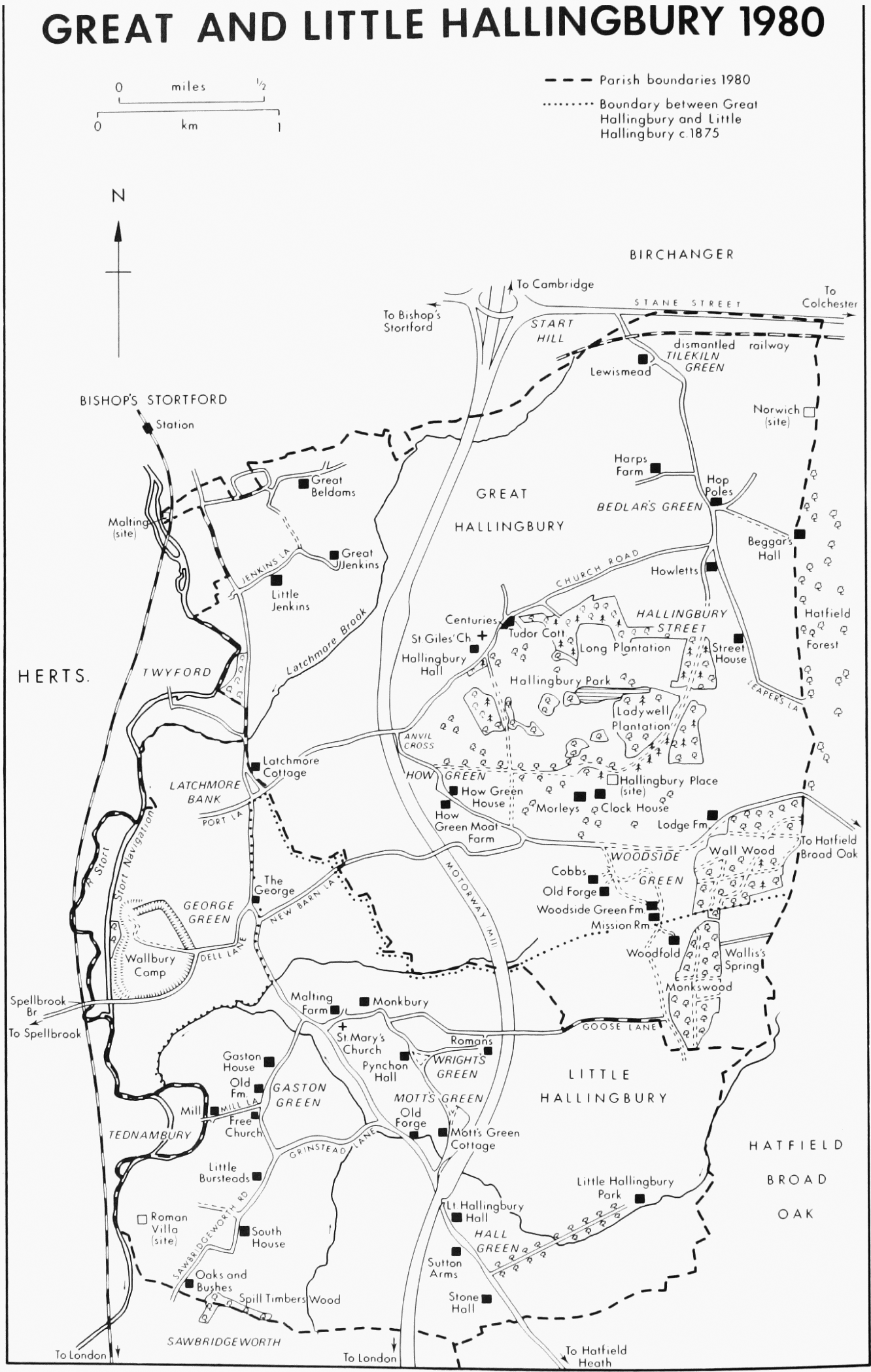
Great Hallingbury is a rural parish 4 km. south-east of Bishop's Stortford (Herts.). (fn. 1) It is within the metropolitan Green Belt and has been designated an area of special landscape value. (fn. 2) It is bounded by Little Hallingbury to the south, Hatfield Broad Oak to the east, Stansted Mountfitchet and Birchanger to the north, and Sawbridgeworth and Thorley (Herts.) to the west, where the river Stort forms the parish and county boundary.
The ancient parish occupied 2,688 a. (1,088 ha.). (fn. 3) In 1953 the south-west corner of the parish, comprising 362 a., and including Wallbury, was transferred to Little Hallingbury, while the north-east corner of Little Hallingbury (194 a.), including Monkswood and the southern part of Woodside Green, was transferred to Great Hallingbury. (fn. 4)
The Stort valley is about 60 m. above sea level. The terrain rises steeply to 70 m. at the summit of Wallbury Camp, and then slopes gradually north-east to 90 m. at Bedlar's Green. Latchmore brook flows south-west from Bedlar's Green to join the Stort. The soil is mainly loam, with glacial gravel and sand in the river valleys. (fn. 5) Wall wood, belonging to the National Trust as part of Hatfield forest, lies in the south-eastern corner of the parish. (fn. 6)
Wallbury Camp is an Iron Age hill fort of 14 ha., surrounded by a double rampart and ditches. Iron Age pottery has been found near the camp and on the site of the church. (fn. 7) Stane Street, a Roman road, forms part of the northern boundary of the parish. Roman pottery has been found near the road, and the church contains Roman brick. (fn. 8)
The recorded population of Great Hallingbury manor was 23 in 1066 but only 13 in 1086. (fn. 9) Twenty-four men were assessed to tax in 1327, and 34 in 1525. (fn. 10) There were 58 houses in the parish in 1670, including 24 with occupiers too poor to be taxed. (fn. 11) The population rose from 549 in 1801 to 710 in 1851, but declined to 490 in 1911. (fn. 12) It rose from 530 in 1921 to 1,001 in 1961, and was 945 in 1971. (fn. 13)
The ancient pattern of scattered settlement has survived to the present day. The parish church, dating from the 11th century, adjoins Hallingbury Hall manor house in the centre of the parish. Wallbury manor house, lying within the ramparts of the hill fort, has been demolished. By the 16th century there was settlement also in the north-east at Bedlar's Green and Tilekiln Green, in the south at Woodside Green and How Green, and on several sites in the north-west. (fn. 14) Early in the 16th century Hallingbury Hall was superseded by Morley House, later Hallingbury Place, which was built 1 km. to the south-east. Hallingbury Place, one of Essex's greatest houses, came to dominate the parish, and its park was in the 19th century extended eastwards to include the whole of Hatfield forest, in Hatfield Broad Oak. (fn. 15) The existence of the park may have restricted development in the centre of the parish, but by the later 18th century there had been a little building in the east at Hallingbury Street, and in the west at Latchmore Bank and George Green. (fn. 16) Norwich, a house lying on the edge of Hatfield forest, existed by 1735. It had gone by 1897. (fn. 17) Hallingbury Place was demolished in 1926, but its park, reduced in size, remains. Twentiethcentury building in the parish includes some council houses in Church Road, and small developments at Dell Lane, George Green, and Beldams Lane.
The ancient road pattern has survived with few changes. (fn. 18) Stane Street, running west to Bishop's Stortford and east to Dunmow, Braintree, and Colchester, was turnpiked in the 18th century. (fn. 19) It is joined near Tilekiln Green by a road running north-west from Hatfield forest as Leaper's Lane and Hallingbury Street. In the 18th century another road ran due north from the forest to Stane Street via Beggars Hall, but that survives only as a footpath. The road from Bishop's Stortford runs south through Latchmore Bank and George Green. In the 18th century it was a coach road. Port Lane runs west from Latchmore Bank. In the 18th century it was joined by a lane from Wallbury and continued north to cross Latchmore brook at Twyford (Herts.). That lane had become a footpath by 1874. Dell Lane runs north-east from Wallbury to George Green, where it joins New Barn Lane, leading north-east to Woodside Green. Church Road runs northeast from Latchmore Bank by Anvil Cross and the church to Bedlar's Green. The road running east from Anvil Cross to How Green and Woodside Green was slightly diverted in 1845 to improve access to Hallingbury park. (fn. 20) Two lanes inside Hallingbury park were closed in the 19th century: the lane from Hallingbury Hall to West Drive became a footpath, while most of the lane across the park to Hallingbury Street was destroyed when the Cedar avenue was planted in the 1860s. The London-Cambridge motorway (M11), completed in 1980, runs through the western side of the parish, the nearest access being at Start Hill, near Tilekiln Green.
GREAT AND LITTLE HALLINGBURY 1980
Spellbrook bridge, which spans the Stort west of Wallbury, was recorded from 1399, originally as Wall bridge. (fn. 21) It was the joint responsibility of the lords of the manors of Wallbury and of Tednambury in Sawbridgeworth. (fn. 22) In 1648 it was in a dangerous condition, and in 1653 it was so decayed that travellers had to swim the river. (fn. 23) It was rebuilt in wood in 1700. (fn. 24) When the Stort navigation was opened in 1769 a second bridge was built east of Spellbrook bridge, to span the canal at Wallbury. (fn. 25) In 1921 Spellbrook bridge was rebuilt by Essex county council in concrete and brick. The canal bridge was taken over in 1972 by Hertfordshire county council. (fn. 26) A bridge at Latchmore Bank was built by the parish in 1711. (fn. 27) How long it survived is not known. In 1856 the vestry resolved to build a permanent bridge over the ford there, and Thorley parish (Herts.) agreed to meet a quarter of the costs of erection and maintenance. (fn. 28)
The Northern and Eastern railway from London, extended to Bishop's Stortford in 1842, skirted the western boundary of Great Hallingbury. The Great Eastern line from Bishop's Stortford to Dunmow and Braintree, opened in 1869, crossed the north-eastern tip of the parish, with a halt at Start Hill. It was closed to passengers in 1952. (fn. 29)
The oldest surviving building in Great Hallingbury, apart from the church, is Harps Farm, which takes its name from the family of John atte Harpe, recorded in 1420. (fn. 30) The early 15thcentury hall and north cross wing survive. Early in the 17th century a chimney was put into the southern end of the hall, the service end was rebuilt and extended to form a new parlour, and the kitchen was moved to the north wing. There are 19th- and 20th-century alterations and additions to the house. Cobbs Farm, at Woodside Green, recorded by that name from 1676, (fn. 31) was also a medieval hall house, of which the south cross wing and part of the hall survive. In the 17th century the hall was remodelled, a chimney stack and upper floor were inserted, and the roof was raised. At some time the north cross wing was removed, but c. 1980 a new timber-framed cross wing was built in its place. Lewismead, at Tilekiln Green, was formerly Lewys, Lewyns, or Lewis's, recorded from 1553. (fn. 32) It has a latemedieval cross wing at the north-east end. The hall, which presumably lay to the south-west, was rebuilt in the early 17th century. The cross wing was extended to the rear, perhaps in the later 17th century. In the 18th century there was a further addition at the south end of the main range. How Green House, east of How Green, has a late medieval cross wing at the southern end which retains a crown post roof. The hall range was rebuilt in the 17th century and at its north end there are alterations and additions of the early 19th century. Early in the 20th century the west front was rendered and given false timbering, and there have been 20th-century additions to the north and west. Tudor Cottage and Centuries, Church Road, form a single building, now two dwellings but formerly more. The roadside block of Tudor Cottage was a small medieval building which retains its smokeblackened roof timbers, into which a chimney and part of an upper floor were inserted in the 17th century. The main block of Centuries was built in the late 18th or early 19th century but incorporates much old material. The singlestorey range between them is probably of the 19th century.
There are several late 16th-century houses. Little Jenkins, Jenkins Lane, was built on a three-roomed plan with two-storeyed, canted bays on the north side of each room; the bays survive only on the upper floor. In 1958 the house was restored and additions were made to the south, partly on the site of a stair turret. (fn. 33) Farther east in Jenkins Lane is Great Jenkins, known in 1553 as Steven Jenkins. (fn. 34) The present house was built in the late 16th or early 17th century to a three-roomed plan, with a first floor jettied on the south, east, and possibly also the west. The ground floor was extended to the line of the upper floor, perhaps in the mid 18th century, when much of the interior was refitted. Woodside Green Farm had a main range of three rooms with a short back wing to the north. Early in the 17th century the east front was remodelled, larger gables with attic windows being placed above the two main rooms. Early in the 18th century a new doorcase with carved brackets to the hood was inserted. Soon after 1800 the main chimney was removed and replaced by a staircase hall, and new chimneys with octagonal shafts in 17th-century style were built on the south gable and between the central and northern rooms. About the same time the back wing was extended. Great Beldams, Beldams Lane, was built to a three-roomed plan which was extended in the 19th century by two short northern wings. The Old Forge, Woodside Green, has a main block with a large internal chimney stack of the late 16th or early 17th century. The longer parallel block at the back may be old at its south end but is partly of the 20th century. Clock House, formerly the stable block of Hallingbury Place, (fn. 35) also dates from the 16th century.
Howletts, in Hallingbury Street, is an early 17th-century house of three-roomed plan with minor additions at the back. Street House, in the same street, is of similar date and plan. The staircase turret on the west side may be original. Beggars Hall, which lies immediately east of the boundary with Hatfield Broad Oak, is now accessible only from Bedlar's Green, and is therefore included here. The name is recorded from 1714, (fn. 36) but the house, of three-roomed plan, was built in the 17th century. It was remodelled and much enlarged in brick in 1959. (fn. 37) Plough Cottage, formerly Angle Close, at Latchmore Bank, also dates from the 17th century. How Green Moat Farm, on a moated side south-east of How Green, probably takes its name from the family of Nicholas del Ho, recorded in 1248. (fn. 38) The house has been considerably enlarged in the 20th century, and many old features have been introduced from other houses, including Theydon Grove, Epping, demolished c. 1965, (fn. 39) while there is much new work in imitation of older styles. The south-east side of the main range incorporates a large chimney stack which may be of 17th-century origin, and the kitchen area may be 19th-century or earlier, but it is otherwise difficult to define the extent of the house before 1900. The barn is of the 18th or early 19th century, and the 18th-century wrought iron gates were introduced c. 1960, at which time a small lake was created.
Eighteenth-century buildings include Parkgate House, at Woodside Green, and Latchmore Cottage, at Latchmore Bank, originally a tworoomed cottage but with extensive 20th-century additions. Among 19th-century buildings are a number of estate houses, at Bedlar's Green and elsewhere, of red brick with blue diaper work and with date stones incorporating the Archer Houblon monogram.
The George inn, George Green, was known as the Shoulder of Mutton in 1709, and in 1754 as the King's Head. (fn. 40) It had taken its present name by 1769. (fn. 41) The building probably dates from the 17th century, with an 18th-century wing on the west. The Hop Poles inn, Bedlar's Green, recorded under that name from 1881, is on the site of a beerhouse existing in 1840. (fn. 42) Hops were formerly grown in the area, but the name may refer to the arms of the Archer Houblons. (fn. 43)
Since Great Hallingbury has no village centre and is near Bishop's Stortford, its residents have depended on the town for most of their goods and services. A postal receiving office had been opened by 1874. (fn. 44) In 1981 there was a sub-post office at Bedlar's Green, combined with a general store, the only shop in the parish.
There have been few notable residents apart from some of the lords of the manors and rectors. Hugh Morgan (d. 1613) apothecary to Elizabeth I, held property in the parish. (fn. 45) Henry F. Johnson (d. 1908), bishop of Colchester, was born in Great Hallingbury. (fn. 46)
Manors
Five estates called Hallingbury were listed in 1086. One, comprising 30 a., and belonging to the bishop of London's fee, had been held in 1066 by Edeva. (fn. 47) No other record of it has been found; perhaps it was an outlier of the bishop's manor of Bishop's Stortford (Herts.). Two other manors, and possibly a third, lay in Little Hallingbury, and are treated there. One was in Great Hallingbury. The manor of GREAT HALLINGBURY or HALLINGBURY MORLEY lay in the centre of the parish. In 1066 it comprised 3 hides and 38 a., held by two free men. In 1086 it was held in demesne by Roger de Otburville. (fn. 48) Soon afterwards it seems to have been acquired by Eudes dapifer (d. 1120). The cartulary of St. John's abbey, Colchester, contains conflicting statements relating to Great Hallingbury in a series of charters, at least some of which were forgeries. According to a purported royal writ dated between 1096 and 1100 Eudes dapifer gave to the abbey the manor and church of Great Hallingbury. (fn. 49) A charter of 1119 attributed to Eudes himself states that he gave to the abbey Great Hallingbury and two-thirds of its tithes. (fn. 50) Henry I in 1119 confirmed to the abbey inter alia two-thirds of those tithes, and in 1120 he confirmed Great Hallingbury, presumably the manor, to Rose, widow of Eudes, as part of her dower. (fn. 51) A charter of the same Rose, dated c. 1120, purported to grant to the abbey the manor of Great Hallingbury as Eudes had held it, and as she had held it after his death. (fn. 52) All the other charters in the series, ranging in date from c. 1120 to 1237, contain confirmations of the abbey's title to two-thirds of the tithes, without mentioning the manor. (fn. 53)
On the evidence above it is improbable that St. John's abbey ever held the manor. After the expiration of Rose's life interest Great Hallingbury seems to have been included, with other lands of Eudes, in the barony of Walkern. It passed with the barony until the death of John de Burgh in 1280, when it fell to the share of his daughter Devorguille, wife of Robert FitzWalter, Lord FitzWalter (d. 1326) of Little Dunmow. Devorguille died in 1284, (fn. 54) and FitzWalter held the manor by the courtesy of England. In 1313 he bought out the reversion of half the manor from their daughter Christine, to whom it had been assigned as her purparty, and in 1315 conveyed the reversion of the whole manor to John Marshal, Lord Marshal (d. 1316), who was apparently a nephew of Christine. When Lord FitzWalter died Great Hallingbury passed to Lord Marshal's sister and coheir Hawise, wife of Robert Morley, Lord Morley (d. 1360). (fn. 55)
The manor descended in the Morley family, with their title, until the death of Robert Morley, Lord Morley, in 1442. His daughter and coheir Eleanor married William Lovel, who became Lord Morley. Eleanor and William, both of whom died in 1476, were succeeded by their son Henry Lovel, Lord Morley (d. 1489), whose heir was his sister Alice (d. 1518), wife of Sir William Parker and later of Sir Edward Howard. She was succeeded by her son Henry Parker (d. 1556), for whom the Morley barony was revived. (fn. 56)
Henry Parker, Lord Morley, was succeeded by his grandson Henry Parker, Lord Morley, who was implicated in the rising of the northern earls in 1570, and fled abroad. Great Hallingbury was then seized by the Crown, but after Henry's death in 1577 it was restored to his son Edward Parker, Lord Morley. (fn. 57) Edward, who in 1586 was one of the judges of Mary, queen of Scots, in 1592 bought Hatfield forest. (fn. 58) He was succeeded in 1618 by his son William Parker, Lord Morley and Monteagle (d. 1622). (fn. 59) William's son Henry Parker, Lord Morley and Monteagle, was sequestrated as a royalist in 1652, when Great Hallingbury was placed in the custody of Major John Wildman. (fn. 60) On Henry's death in 1655 his son Thomas, Lord Morley and Monteagle, recovered the estate, which he sold in 1666 to Sir Edward Turnor (d. 1676) of Little Parndon, Speaker of the House of Commons. (fn. 61) After the death of Sir Edward's son, also Sir Edward Turnor, in 1721, the estate was vested in trustees to be sold to pay his debts. (fn. 62)
In 1729 the Hallingbury estate was bought by the executors of Sir Richard Houblon, to be settled on his kinsman Jacob Houblon (d. 1770). (fn. 63) It passed in the direct line of the Houblons until the death of John Archer Houblon in 1891. He was succeeded by his nephew George Bramston Eyre, who took the name of Archer-Houblon. G. B. Archer-Houblon (d. 1913) was succeeded by his son Henry L. Archer-Houblon. The estate, comprising 3,140 a., mainly in Great and Little Hallingbury and Hatfield Broad Oak, was put up for sale in 1923, and was broken up. (fn. 64)
The original manor house of Great Hallingbury seems to have gone by 1435, when its site only was mentioned. (fn. 65) Hallingbury Hall, probably a later building on the same site, was recorded from 1571; it adjoined the church to the south-west. (fn. 66) In 1653 it was timber framed, with nine rooms. (fn. 67) The main part of the present house is of red brick with slate roof, and contains bricks dated 1813. At the rear are two parallel ranges of the 16th and 17th centuries, containing service rooms. Part of the homestead moat survives.
Early in the 16th century Hallingbury Hall was superseded by a new and grander residence called Morley House, later Hallingbury Place, built about 1 km. south-east of the church, probably by Henry Parker, Lord Morley (d. 1556). It was of brick, possibly half-H-shaped, with wings extending south. (fn. 68) Elizabeth I stayed there in 1561 and 1576. (fn. 69) In 1653 the house had 45 rooms. (fn. 70) Jacob Houblon (d. 1783), who succeeded to the estate in 1770, reconstructed and enlarged Hallingbury Place in 1771–3 to the designs of John Redgrave, replacing the mullioned windows with sliding sashes, dividing up the first floor gallery, and building a square tower with domed roof at each of the four corners of the house. (fn. 71) New gardens were laid out to the designs of 'Capability' Brown. (fn. 72) John Archer Houblon in 1857 inclosed Hatfield forest, and in the following years incorporated it into the grounds of Hallingbury Place. (fn. 73) The house was leased in 1910 to Lockett Agnew, who modernized the interior and replanned the gardens. (fn. 74) In 1923, when it was put up for sale, Hallingbury Place contained 7 reception rooms, 12 bedrooms and dressing rooms on the first floor, 20 staff bedrooms on the second floor, and 7 bathrooms. (fn. 75) A two-storey extension at the north-west corner included another sitting room and a bedroom. The stable-block contained 10 bedrooms and a mess room. The house was demolished in 1926, and only the 16th-century brick stable-block, converted into a modern dwelling, still stands. (fn. 76) Some of the materials from Hallingbury Place were used to build a new house, Morleys, about 200 m. to the west.
The manor of LA WALLE, later WALLBURY, on the southern border of the parish, probably took its name from the Iron Age hill fort, near the river Stort; (fn. 77) it seems originally to have included Wall Wood on the Hatfield Broad Oak boundary. (fn. 78) It has been suggested that it was the manor of 'Walla', held in 1086 by Richard FitzGilbert of Clare, (fn. 79) but that is not borne out by the descent of La Walle. In 1301 Hatfield Broad Oak, the hamlet of La Walle, and the adjoining Monkswood in Little Hallingbury, were included in the forest of Essex as ancient Crown demesne. (fn. 80) If La Walle and Monkswood were indeed ancient demesne they had probably belonged in 1086 to Hatfield Broad Oak, then the only royal manor in Harlow hundred. (fn. 81) In 1219 land in Hallingbury, i.e. La Walle, was claimed by Richard de Montfitchet as the fee of his great-grandmother Margery de Montfitchet. (fn. 82) Margery's husband William de Montfitchet (d. by 1156), had succeeded to many of the lands held in 1086 by Robert Gernon. As a tenant in chief Gernon held a great honor based at Stansted Mountfitchet, which adjoined Hatfield Broad Oak and Great Hallingbury to the north. (fn. 83) The honor itself did not extend into Hatfield or Great Hallingbury, but among Gernon's other lands were three distinct properties in Hatfield, all of which were in 1086 listed under the king's manor. The first, comprising 30 a., had been held under Edward the Confessor by a smith who was executed for theft, whereupon it was seized by the king's reeve. The second, comprising 40 a. of woodland, had also been held by King Edward's reeve. Osmund the Angevin had disseised the king's reeve and the manor of both properties. The third estate, of ½ hide, had been held in 1066 by a sokeman. (fn. 84) It is not clear whether Robert Gernon held the three estates by right or usurpation. Doubt on that score may explain Richard de Montfitchet's revival of an ancient claim.
Whether or not La Walle had been part of Hatfield Broad Oak it was certainly in the king's hands by 1189 or 1190, when Richard I granted half of it to Walter de Hauville, to hold by serjeanty of keeping the king's falcons. (fn. 85) Richard de Montfitchet's claim of 1219, made against Walter, must have failed, for Walter's half of the manor passed in 1220 to his nephew Gilbert de Hauville. (fn. 86) In 1240 Henry III granted Gilbert's land of La Walle to Roger de Ros, the king's tailor, to hold in fee, rendering a silver bodkin or Id. a year. Gilbert de Hauville, who was infirm, was to remain in occupation of the land for life, paying ½ mark a year to Roger de Ros. (fn. 87)
The other half of the manor was granted by Richard I in 1190 or 1191, also in falcon serjeanty, to Richard FitzAucher who was still holding it in 1208. (fn. 88) It later passed to Ralph Purcel, whose widow in 1215 held 1/6 of the manor in dower. (fn. 89) In 1235 Edmund, son of Ralph, held La Walle jointly with Gilbert de Hauville. (fn. 90) There is no later record of Edmund's holding.
Roger de Ros, also called Taylor, died in 1256 or 1257 holding La Walle, then containing 222 a. (fn. 91) In 1262 the king confirmed the manor to Henry le Flemmeng, to whom it had been granted by Roger's sisters Emeline de Ros and Thomasine, widow of William of Rouen. It later escheated to the Crown as 'lands of the Normans', and in 1267 was granted by Henry III to his halfbrother William de Valence, earl of Pembroke (d. 1296). (fn. 92) William's son and heir Aymer de Valence, earl of Pembroke (d. 1324), in 1321 settled Wallbury for life on his third wife Mary. (fn. 93) On her death in 1377 the manor passed to Aymer's grandnephew John Hastings, earl of Pembroke (d. 1389). (fn. 94) Hastings died childless, and there followed a long struggle for his lands between his kinsmen.
Most of Hastings's estates, including Wallbury, had been entailed on William de Beauchamp, later Lord Abergavenny. Beauchamp, who was descended from a sister of Hastings's grandmother, seems to have joined forces with Reynold de Grey, Lord Grey of Ruthin, who was descended from a sister of Hastings's grandfather, and Wallbury was at first awarded to them. In 1396 they were ejected by Richard Talbot, Lord Talbot, leader of three claimants descended from sisters of Aymer de Valence, earl of Pembroke, but Talbot died in the same year, and in 1397 Wallbury was restored by Chancery decree to Grey and Beauchamp. (fn. 95) In 1400, by the king's order, Grey vested the manor in trustees, who in 1401 conveyed half Wallbury wood to Beauchamp. (fn. 96) In 1402 Grey was captured by the Welsh rebel Owain Glyn Dŵr, and had to sell some of his lands, including Wallbury, to raise the ransom for his release. Grey's trustees in 1404 conveyed the manor to Richard Rede and others. (fn. 97)
Richard Rede in 1412 held lands in Great Hallingbury worth £10 a year. (fn. 98) In 1431 he conveyed Wallbury to trustees with the intention of evading the Crown's rights of wardship over his son John, then a minor. Later in the same year the trustees paid 40 marks for a royal pardon for that action, but on Richard Rede's death in 1432 the manor was nevertheless taken into the king's hand. On John Rede's death in 1436 the king granted Wallbury to William Wetenhall (Wetnale), grocer of London, the sole surviving trustee appointed by Richard Rede. (fn. 99) Wetenhall's title was disputed by Edmund de Grey, Lord Hastings and Ruthin, cousin and heir of Reynold de Grey, Lord Grey, but in 1442 Edmund renounced his claim. (fn. 100) Wetenhall (d. 1457) was succeeded by his son William (d. 1468), whose infant heir was another William Wetenhall. (fn. 101) William Wetenhall, probably the last named, held Wallbury in 1489 and 1520. (fn. 102) George Wetenhall, who held it in 1555, was succeeded at his death in 1573 by his son Thomas, who sold Wallbury in 1576 to Thomas Meade, later a justice of Queen's Bench. (fn. 103) Meade sold the manor in 1584 to Edward Parker, Lord Morley. (fn. 104) Wallbury was thus merged with the manor of Great Hallingbury, with which it thenceforward descended until the estate was broken up in 1923. (fn. 105) Wallbury, comprising 189 a., was then put up for sale, and it changed hands several times in the following years. (fn. 106)
Wallbury House lay near the Stort, within the ramparts of the hill fort. In the 17th century it was a timber-framed building of 10 rooms. (fn. 107) In 1840 the adjoining grounds covered 52 a. A narrow plantation of woodland skirted the outer edge of the fort. (fn. 108) The house had been demolished by 1876. (fn. 109) Its barn, probably of the 15th century, survived until the Second World War, when it was destroyed by bombing. (fn. 110)
Economic History
Great Hallingbury in 1086 was a small and declining manor. There were 25 a. of meadow, pasture worth 28d., woodland for 600 swine, and a mill. The recorded population comprised 8 villeins and 5 bordars, and there were 5 ploughteams. In 1066 there had been 18 villeins, 4 bordars, a serf, and 16½ ploughteams. It was stated in 1086 that 9 ploughteams could be employed, which suggests that part of the arable had been permanently converted to other uses. That may be partly explained by an increase in livestock other than plough oxen. In 1066 there had been 30 sheep, 40 swine, 3 'beasts', and a rouncey, but in 1086 there were 120 sheep, 80 swine, 8 'beasts', a rouncey, and 3 hives of bees. The total value of the manor had fallen from £11 in 1066 to £6 in 1086. (fn. 111)
The extensive Domesday woodland probably lay on the eastern side of the parish, adjoining Hatfield forest. (fn. 112) It was reduced by assarting and inclosure in the 12th century. (fn. 113) The park of Great Hallingbury manor, which was inclosed by 1130, comprised 202 a. in 1379. (fn. 114) The agistment of the park was worth 10s. a year in 1360, although the underwood was barely sufficient to provide timber for the annual enclosure. (fn. 115) In the early 15th century the warden of the park and the warren, appointed for life, had a house in the park and a daily wage of 2d. (fn. 116) The amount of open woodland seems to have been further reduced in the mid 16th century by the inclosure of New park, which was probably carried out when Morley House was built. New park included pasture as well as woodland, and some of it had already been inclosed in small parcels. (fn. 117) Its northern section, called Nether New park, included the pond next to the parish church; to the south lay Upper New park. (fn. 118) By 1653 the woodland in the parks of Hallingbury manor was limited to a few copses of 2 or 3 a. (fn. 119) The landscaping carried out at Hallingbury Place in the later 18th century included woodland, and by 1840 Lady Well and Long plantations comprised 12 a. and 17 a. respectively. (fn. 120)
The woodland of Wallbury manor in 1346 consisted mainly of Wall Wood, adjoining Hatfield forest. (fn. 121) A park of 16 a. was inclosed by 1377, but 80 a. of woodland remained on the manor in 1574. (fn. 122) Attempts to inclose the wood were resisted in 1610 and 1648, but 57 a. had been converted to arable by 1653. (fn. 123) In 1840 Wall Wood comprised 62 a. of the 139 a. of woodland in the parish. (fn. 124) It was conveyed to the National Trust, as part of Hatfield forest, in 1946. (fn. 125) Small patches of woodland survive elsewhere in the parish.
In 1653 the tenants of Great Hallingbury manor were entitled to take timber within the parks for kindling and the repair of gates, fences, ploughs, and carts, but they no longer enjoyed common pasture in the manorial woodlands and wastes. (fn. 126) At an earlier date there had probably been common pasture at Bedlar's Green in the north and How Green in the south, where inclosed fields called the Common were recorded in 1840. (fn. 127) Wallbury manor's tenants in 1653 had pasture rights on Wallbury common, then some 75 a. (fn. 128) At that period they claimed the right to cut timber for fencing and gating the common, to cut bushes between All Saints' day (1 November) and St. George's day (23 April), to dig for clay, and to keep a bull and a boar. They refused to allow the lord of the manor to pasture his beasts on the common. (fn. 129) Wallbury common was probably identical with Woodside Green, which adjoins Wall Wood to the west. In 1840 Woodside Green comprised 42 a. out of the 45 a. of common land remaining in the parish. (fn. 130) It was given in 1936 to the National Trust, which recognizes the ancient grazing rights there. (fn. 131)
There were open fields on Great Hallingbury manor in the Middle Ages. In 1313 the demesne of half the manor, contained 191 a., lying in four fields, one of which, Southstead, contained 61 a. (fn. 132) Inclosure of the open fields was well advanced by the later 16th century, when the courts of both Great Hallingbury and Wallbury manors often issued injunctions against hedgebreaking. (fn. 133) Many of the tenants of Wallbury manor had inclosed their fields by 1580. (fn. 134) An open field called Sheephoe still survived in 1645. (fn. 135) Field names in 1840 suggest the previous existence of large open fields in the north: Harps farm contained two fields called Further Rowleys and one called Hither Rowleys, while Jenkins farm included Great Rowleys and Little Rowleys. Long, narrow fields west of Woodside green, recorded at the same time, are even clearer evidence of earlier open field farming. Similar strip-shaped fields along the east bank of the river Stort had probably been part of common meadows. (fn. 136)
In 1275 only 56 a. of arable on Great Hallingbury manor were held by customary tenants. (fn. 137) The relatively small number of customary tenants was probably due to the presence of molmen, who held mainly by money rents. (fn. 138) In 1313 one half of the manor contained 8 free tenants, 16 molmen, and 18 customary tenants. The customary tenants, besides performing services on the lord's demesne, owed chicken and egg rents. (fn. 139) In 1426 they owed a total of 70 works, the cash value of which was stated. (fn. 140) By the mid 16th century most labour services had been commuted for money rents. In 1571 the free tenants on the manor owed total rents of 51s. and 6 capons, while the copyholders owed £15 18s. 4d. rents, 8 capons, and 13s. for 'worksilver'. (fn. 141) In 1614 capon rents were still due on both Great Hallingbury and Wallbury manors, but they had disappeared by 1653. (fn. 142)
Recorded figures suggest that arable farming always predominated in the parish. Wallbury manor in 1267 contained 200 a. of arable, 18 a. of meadow, and 4 a. of pasture. (fn. 143) There were 120 a. of arable in 1377. (fn. 144) In 1653 there was little permanent pasture in Wallbury or in Great Hallingbury manor except in Hallingbury park. (fn. 145) Over 60 a. of arable in New park were ploughed up in 1678. (fn. 146) In the early 19th century John Houblon was said to have laid down much grass, but the soil was not entirely suitable, and needed much preparation. (fn. 147) In 1838 the parish was estimated to contain 1,637 a. arable and 681 a. pasture. (fn. 148) The proportion of arable fell in the later 19th century, but has risen again during the present century. Returns for 1866 included 1,351 a. of cereals, 334 a. of vegetables, and 765 a. of grass. Those for 1906 list 772 a. of cereals, 235 a. of vegetables, and 1,160 a. of grass. By 1926 cereals had increased to 1,267 a., but vegetables had fallen to 111 a. and grass to 1,239 a. The 1977 returns list 718 ha. (1,774 a.) of cereals, 139 ha. (343 a.) of vegetables, and 190 ha. (469 a.) of grass. (fn. 149) In all four returns wheat was the main cereal, and beans were the largest vegetable crop. In the above figures uncropped fallow, when listed, has been included in the total for grass.
There was a hop garden on Wallbury manor in 1614 and 1648. It may have been the former hop ground, near Spellbrook bridge, mentioned in 1770. (fn. 150) In 1653 there was a hop ground on Hallingbury Hall farm and another on Harps farm. (fn. 151) A hop ground formed part of the glebe in 1783. (fn. 152) In 1840 Lewis's farm, north of Harps, included Hop ground meadow, field, and pasture. (fn. 153) A field called the Vineyard, part of Wallbury manor demesne in 1653, probably indicates viticulture at an earlier date. (fn. 154) Two fields at Wallbury, comprising 19 a., were called the Vineyards in 1840. (fn. 155) In 1981 there were nursery gardens at Bedlar's Green and Hallingbury Street.
In the early 19th century John Houblon kept 300 Southdown sheep on his Hallingbury estate. (fn. 156) Returns for 1866 list 620 sheep, 177 pigs, 50 cows, and 91 other cattle. In 1906 there were 507 sheep, 97 pigs, 83 horses, 64 cows, and 168 other cattle. By 1926 cows and heifers had increased to 185, and there were 71 other cattle, 127 pigs, 81 horses, but only 14 sheep. In 1977 there were 508 cattle, 331 pigs, and 170 poultry. (fn. 157) In 1981 there was a small goat farm at How Green.
From the late 16th century the Hallingbury estate, held in succession by the Parkers, the Turnors, and the Houblons, comprised the greater part the parish: in 1840 John Archer Houblon owned 2,100 a. in Great Hallingbury. (fn. 158) Most of the land was let to tenants, whose holdings were gradually consolidated into larger farms. How Green farm comprised 56 a. in the 16th century, Great Jenkins 62 a. in 1579, and Harps 60 a. in 1647. By 1840 they measured 166 a., 132 a., and 257 a. respectively. (fn. 159) In 1840 there were 12 farms in the parish of 50 a. or more. The largest, Hallingbury Hall farm (370 a.), included Lodge farm. One farm contained between 200 and 300 a., four between 100 and 200 a., and six between 50 and 100 a. (fn. 160) The 1906 returns list two farms over 300 a., and ten between 50 and 300 a. In 1926 there were two over 300 a., five between 150 and 300 a., two between 100 and 150 a., and three between 50 and 100 a. Returns for 1977 show one farm over 500 ha. (1,235 a.), two between 100 ha. (247 a.) and 200 ha. (494 a.), and three between 10 ha. and 100 ha. (fn. 161)
The mill on Great Hallingbury manor in 1086 may have been the predecessor of the water mill recorded in 1275. (fn. 162) A fulling mill on the manor, mentioned in 1571, may have stood on the south bank of Latchmore brook west of Hallingbury Hall, where Great and Lower Mill fields were recorded in 1840. (fn. 163) There was a windmill on Jacob Houblon's estate in 1729. (fn. 164) It may have stood on the moated mound in Hallingbury park which survived until c. 1980, when it was ploughed out. (fn. 165) Windmill spring, lying west of Harps farm in 1840, may have been another windmill site. (fn. 166) Wallbury manor had a mill in 1267. (fn. 167) Two fulling mills were recorded there in 1432, and one in 1545. (fn. 168)
The textile industry, indicated by the presence of fulling mills, may have originated as early as 1237, when William of Hallingbury supplied cloth to Henry III. (fn. 169) Tile and brickmaking was recorded in the parish from 1553, when William Naylor owed an annual rent of 1,000 tiles. His descendant John Naylor was still paying it in 1653. (fn. 170) The industry presumably gave its name to Tilekiln Green. In 1653 Great and Little Brickhill fields were recorded on Lodge farm, and Brickhill field on Hallingbury Hall farm. (fn. 171) There are references to brickmaking and brickmakers in the late 17th and 18th century. (fn. 172) About 1875 there were brickworks at Bedlar's Green. (fn. 173) They were then on lease to Cannon & Son, who bought them in 1923. (fn. 174) F. Cannon & Sons were still trading in 1937, but the works were derelict in 1981. (fn. 175) Gravel was dug in the north and west of the parish. In 1806 the parish vestry granted compensation for damage to pasture caused by stacking and carting gravel. (fn. 176) Four Gravel Pit fields were recorded in 1840, two west of Latchmore Bank, one west of Little Jenkins, and one west of Tilekiln Green. (fn. 177) There was a gravel pit north-west of Little Jenkins in 1958. (fn. 178)
A malting in the parish had been closed for two years up to 1820, when the vestry offered the owner exemption from rates for the next two years if he would reopen it. (fn. 179) In the mid 19th century two large maltings were built in the north-west corner of the parish, near the railway. They had been converted to timber stores by 1974, and were demolished in 1979. (fn. 180) A basket maker was trading in the period 1878–94. (fn. 181) In 1981 several small industries were located at How Green Moat farm, including the packing of straw and sawdust for domestic pets, light engineering, coat making, and decorative straw weaving. There was a joinery, Anderson Manson, at Tilekiln Green. Thames Water (Lee Division) works, west of Little Jenkins, included Bishop's Stortford sewage works, opened c. 1870. (fn. 182) A fair, held at Woodside Green on Whit Tuesday, was recorded in the 18th and earlier 19th century. (fn. 183)
Local Government
In 1274–5 the lord of Great Hallingbury manor claimed the rights of gallows, assizes of bread and of ale, and free warren. (fn. 184) In the late 14th century the court leet was held on Whit Monday. (fn. 185) Court rolls of the manor survive for the period 1578–1925 with a few minor gaps. Courts leet in the later 16th century were usually held annually in the autumn, but occasionally in March or April. In the later 17th century they were sometimes held twice a year, but in the 18th century only once a year. The leet appointed a constable annually until the early 17th century. From that time the parish gradually assumed responsibility, although occasional appointments were made by the leet until 1766. (fn. 186)
The lord of Wallbury manor in 1274–5 claimed view of frankpledge and the assizes of bread and of ale. (fn. 187) Court rolls survive for the years 1399– 1441, 1491–1507, and 1576–1759. By 1399 the court leet was usually held annually on the Wednesday after Corpus Christi. By the later 16th century it was being held at irregular intervals, but occasional meetings continued until the early 18th century. A constable was appointed annually until the end of the 16th century, and infrequently until 1687. A reeve or hayward was appointed in 1648. (fn. 188)
Parish records include churchwardens' accounts (1526–1630), and vestry minutes (1647–1739, 1779–81, and 1801–61). (fn. 189) Between 1647 and 1709 vestry meetings, irregularly recorded, seem usually to have been held twice a year. In 1703 the vestry resolved to meet monthly, but there is no evidence that it did so, and from 1710 to 1739 only the Easter meeting was recorded. From 1779 to 1781 more frequent vestries were held: 9 in 1780 and 10 in 1781. The Easter vestry was noted from 1801 to 1804, but later meetings were infrequently recorded. Attendances, as indicated by those signing the minutes, were between 5 and 8 until 1719. They ranged from 8 to 14 between 1720 and 1738, and fell to 6 or fewer between 1779 and 1781. After 1801 they were usually between 4 and 9. The rector signed first when present. William Hales, rector from c. 1648 to 1690, attended regularly between 1654 and 1659, and later occasionally. Edward D'Auvergne, rector 1701–37, missed only four Easter vestries. John Archer Houblon, lord of the manor, often took the chair in the 1820s and 1830s. Parish clerks were recorded in the early 18th century. John Guiver (d. 1733) was clerk for over 40 years. (fn. 190)
There were two churchwardens, except in 1537, 1558, 1728–39, and 1801–32, when there was one, and in 1581, 1598, and 1617–18 when there were three. Sir Edward Turnor served as churchwarden from 1687 to 1721, and his son Charles from 1722 to 1727. There were usually two overseers of the poor. A woman served in 1682, 1729, and 1731–2. An assistant overseer was recorded in 1831. From 1801 the overseers were allowed salaries in addition to travelling expenses. Two constables, sometimes serving for two years, were appointed by the parish from 1647 or earlier. In 1696 they were appointed by Great Hallingbury manor court, but they accounted to the vestry the following year. Separate rates were levied for the constables until the mid 18th century. Two highway surveyors were recorded from 1669 to 1704. Sir Edward Turnor served in 1687. The surveyors' expenses were sometimes paid by the other officers, but a separate highway rate was recorded in 1668, 1672, 1673, and 1806.
In 1709 regular doles were being paid to 11 paupers. A workhouse existed from 1773, when Newhouse, with barns, outhouses and gardens, was acquired for 'parish profits and advantages'. (fn. 191) The income from spinning was recorded from 1779 to 1781. The workhouse, at Hallingbury Street, was closed in 1835 and was later sold. The vestry agreed in 1801 to open a shop selling provisions to the poor at almost cost price. In 1809 an intricate scheme was drawn up for distributing flour according to the size and age of families. Free bread and fuel were distributed in 1830 and 1831. In 1832 John Archer Houblon provided some 17 a. (6.9 ha.) of land at a nominal rent to be farmed by the unemployed. Four parish officials were to supervise the work and sell the produce, which was to be stored in a barn at How Green. In 1835 the parish raised £50 to pay for four men to emigrate to America. Medical care was provided casually in the 18th century. A part-time surgeon was employed from 1815.
Poor relief cost £8 14s. in 1614. (fn. 192) During the period 1721–30 it averaged £89, with a peak of £113 in 1730. It rose to £180 in 1776, and to an average of £252 in the three years 1783–5. (fn. 193) Between 1806 and 1817 the average was £848, with peaks of £1,193 in 1813 and £1,343 in 1817. (fn. 194) In 1836 Great Hallingbury became part of Bishop's Stortford poor law union.
Church
Architectural evidence shows that Great Hallingbury church existed in the 11th century. The advowson of the rectory was held by the lord of the manor of Great Hallingbury until 1924, when it was conveyed to the bishop of Chelmsford. Between the 15th and the 18th centuries occasional presentations were made by others for one turn, notably by the queen in 1582 and the king in 1701. (fn. 195) The Houblons, when they bought the Hallingbury estate in 1729, had to fight a legal action to establish their title to the advowson. (fn. 196)
Two thirds of the tithes of the demesne of Great Hallingbury manor were given to St. John's abbey, Colchester, by Eudes dapifer, lord of the manor, in or before 1119. (fn. 197) The abbey still held them in 1291, when they were valued at £3 6s. 8d., but in 1296, after disputes between the abbey and the rector of Great Hallingbury, the bishop directed that in future all tithes should be received by the rector, who was to pay the abbey annually 5½ marks (£3 13s. 4d.). (fn. 198)
The rectory was valued in 1254 at £6 13s. 4d., in 1291 at £5 6s. 8d., and in 1535 at £22. (fn. 199) In 1541 the rector, John Adcock, with the bishop's consent, granted an 80-year lease of the rectory to Charles and Thomas Parker, members of Lord Morley's family, who undertook to maintain the rectory house, to pay to the Crown the rent charge formerly due to Colchester abbey, and to meet half the first fruits tax on the benefice. The rector was to have the use of certain rooms in the house. (fn. 200) In 1552 Lord Morley redeemed the rent charge from the Crown. (fn. 201) The Morleys seem to have maintained their control over the rectory almost up to the Civil War. They sublet the glebe and the rectory house, and, as late as 1629, appear to have extracted from a new rector an undertaking to lease the corn tithes to them. (fn. 202)
In 1610 there were about 76 a. of glebe. (fn. 203) The rectory was valued in 1650 at £134, including £110 from tithes and £24 from the house and 50 a. of barren glebe. (fn. 204) The Morleys seem no longer to have had any financial interest in it. In 1788 the rectory was valued at £250. (fn. 205) The tithes were commuted in 1840 for £720; there were then 58 a. of glebe. (fn. 206) By 1922 all the glebe except 5 a. had been sold. (fn. 207)
The Rectory house may originally have stood within the moat which still partly survives 300 m. north-east of the church, in the grounds of Glebe House. By 1777, however, the house was outside the moat, to the south. (fn. 208) In 1878 it was rebuilt on the same site, in a style said to have been copied from a Scottish mansion. (fn. 209) A new Rectory was built in 1947, opposite the church. The Rectory of 1878 survives as Glebe House, with 7 a. of garden and paddock. (fn. 210)
Rectors are recorded from the 13th century or earlier, but the list is far from complete before 1553. (fn. 211) Between 1393 and 1490 there were at least 11, of whom 5 left by resignation. Thomas Horston, 1393–1410, was also a canon of St. Paul's, London. (fn. 212) Another pluralist was William Lincoln, rector 1440–8 and bishop of Dunkeld (Scot.). (fn. 213) From the 16th century incumbencies grew longer: there were no more than 22 rectors between 1553 and 1954, including three who stayed for over 40 years.
Richard Amadas, rector 1585–1629, was denounced by Puritans as 'an unpreaching minister.' (fn. 214) Edward Thurman, rector from 1629, is said to have threatened to drive all Puritans out of the parish. His opponents charged him with simony, fornication, drunkenness, and neglect of duty, and he was sequestrated in 1643. (fn. 215) William Hales was serving the cure by 1648. It has been suggested that he had been chaplain to the Barringtons at Hatfield Broad Oak. In 1654 he was admitted to the rectory by the Triers. Although Thurman was apparently still living in 1660 Hales was left in possession, and he remained at Great Hallingbury until 1690. (fn. 216) Robert Huntington, rector 1692–1701, was an orientalist and later bishop of Raphoe (Irel.). (fn. 217) Edward D'Auvergne, rector 1701–37, had been chaplain to the Scots Guards during William III's campaigns in Flanders, of which he became the historian. (fn. 218) Henry M. Oswald, rector 1873–1903, was brother-in-law of the squire, John Archer Houblon. (fn. 219) During his incumbency the church was restored and enlarged, and the Rectory was rebuilt. Leonard Elliott-Binns, rector 1933–4, was a well known writer on theology and church history. (fn. 220)
The Trinity guild of Great Hallingbury existed in 1525, when it had 25 members. Between 1528 and 1543 it contributed varying sums to church funds. Rent from a 'guild cow' was part of the church income from 1543 to 1546. That was presumably the cow 'sometime belonging to the Trinity guild' which was held by the church in 1547. No later reference has been found to the guild. Between 1525 and 1548 the church derived income from a few other cows and sheep, and from a house called Copped Hall, which was rebuilt in 1533–4. (fn. 221)
The church of ST. GILES (fn. 222) comprises nave, chancel, north aisle and chapel, west tower with spire, and south porch. (fn. 223) The walls are of flint rubble, with dressings of Barnack stone, clunch, and Roman brick. The building was remodelled and enlarged in 1874.
Two features of the late 11th century have survived: the chancel arch, which is mainly of Roman brick, reset, and a small round-headed window in the nave. The chancel was rebuilt in the later 13th century, and the west tower added or rebuilt c. 1400. During the later Middle Ages a rood loft was built, with a stairway cut into the north side of the chancel arch. A piscina, which probably served an altar in the rood loft, survives high on the east wall of the nave, south of the chancel arch. A timber spire existed by 1527, when it was reshingled, but in 1738 it was struck by lightning and burnt down. (fn. 224) It seems to have been replaced by a small conical structure. (fn. 225) Between 1549 and 1551, in accordance with government policy, the church was stripped of its 'superstitious' furnishings, including the rood screen, the tabernacle over the high altar, and the Easter sepulchre. The process was reversed between 1553 and 1555, with the aid of a royal grant of £11. (fn. 226)
The building scheme of 1874 was planned and financed by John Archer Houblon of Hallingbury Place, to the designs of G. E. Pritchett. The nave and chancel were largely rebuilt, and the north aisle, south porch, and spire were added. Houblon himself helped to design the capitals of the new nave arcade, which depict the leaves and fruit of local plants.
The church has five bells, the oldest of which was cast in 1542. (fn. 227) The plate includes a silver cup and paten, both of 1662. (fn. 228) Fragments of small alabaster images, dating from the 15th century and probably from an altar piece, were found in the church during the restoration of 1874. They are now in the Colchester and Essex Museum. (fn. 229) Two funeral helms belonging to the church date from the 16th century. One of them, originally a tourney helm, may have been carried at the funeral in 1556 of Henry Parker, Lord Morley; it is now in the Victoria and Albert Museum, London.
In the choir vestry are indents of part of a brass to Henry Parker, Lord Morley (d. 1556), and earlier members of the Lovel and Parker families. (fn. 230) They come from an altar tomb formerly in the chancel. Another altar tomb there, to Sir Edward Turnor (d. 1721), no longer survives. (fn. 231)
Woodside Green mission room, built by 1915, was still in use in 1981. (fn. 232)
Roman Catholicism. (fn. 233)
In the later 16th and the earlier 17th century the Parkers, Lords Morley, and their family were prominent recusants. William Parker, Lord Mounteagle, later Morley and Mounteagle (d. 1622), became a Protestant in 1605, and in the same year received a warning which led to the detection of the Gunpowder plot. (fn. 234) Some members of his family, however, remained Roman Catholics. Several other recusants were living in the parish in the earlier 17th century.
Protestant Nonconformity
A few dissenters were recorded c. 1766 and in 1810. (fn. 235) A nonconformist meeting house was listed in 1829. (fn. 236)
Education
Great Hallingbury Church of England primary school originated c. 1819. In that year the parish had a Sunday school with some 80 children, supported by subscriptions, and another school, held weekly, where 12 girls were taught and partly clothed at the expense of a private benefactor. (fn. 237) By 1820 the two schools seem to have united as a National day and Sunday school for 75. (fn. 238) The National school is said to have met in a cottage, near the church, later called Centuries. (fn. 239) During the 1830s it received grants from parish rates, but by 1846 it was entirely supported by the rector. (fn. 240) In 1851 John Archer Houblon built a new school for 200 next to the church. (fn. 241) Samuel Page, by his will proved 1862, gave £25 in trust to the school. In 1978 an income of 60p was received from the endowment. (fn. 242) The school received government grants from 1872. (fn. 243) The Archer Houblons helped to maintain it until 1924. (fn. 244) In 1948 the school was reorganized for juniors and infants and was granted Controlled status. It was closed in 1981. (fn. 245) The building, which includes a teacher's house, is in Gothic style, of red brick with blue diapering.
Charities for the Poor. (fn. 246)
John Till, by his will dated 1637, gave a 14s. rent charge from land in Great Hallingbury to the parish poor. (fn. 247) Its receipt and distribution are recorded for the years 1703–7, 1714–30, and 1737–42. By 1786 the land had been divided. In 1835 it was stated that no payment had been received from one part since 1808, nor from the other since 1823. One part of the rent charge was received from 1833 until 1852. (fn. 248)
An unknown donor gave £20 for the parish poor, which by 1703 was producing £1 a year. In 1729 it was said to have been used to buy a house for the poor, but from 1737 the gift was again producing £1 a year. In the early 1830s the gift, with subscriptions, was used to provide bread, clothing, or fuel. By 1890 it seems to have been combined with money given by John Archer Houblon, and in that year the total stock amounted to £211. In 1978 the income of £744 was spent on gifts to the sick and old, and on the care of graves.