A History of the County of Essex: Volume 8. Originally published by Victoria County History, London, 1983.
This free content was digitised by double rekeying. All rights reserved.
'Parishes: Sheering', in A History of the County of Essex: Volume 8, ed. W R Powell, Beryl A Board, Nancy Briggs, J L Fisher, Vanessa A Harding, Joan Hasler, Norma Knight, Margaret Parsons (London, 1983), British History Online https://www.british-history.ac.uk/vch/essex/vol8/pp240-249 [accessed 30 April 2025].
'Parishes: Sheering', in A History of the County of Essex: Volume 8. Edited by W R Powell, Beryl A Board, Nancy Briggs, J L Fisher, Vanessa A Harding, Joan Hasler, Norma Knight, Margaret Parsons (London, 1983), British History Online, accessed April 30, 2025, https://www.british-history.ac.uk/vch/essex/vol8/pp240-249.
"Parishes: Sheering". A History of the County of Essex: Volume 8. Ed. W R Powell, Beryl A Board, Nancy Briggs, J L Fisher, Vanessa A Harding, Joan Hasler, Norma Knight, Margaret Parsons (London, 1983), British History Online. Web. 30 April 2025. https://www.british-history.ac.uk/vch/essex/vol8/pp240-249.
In this section
SHEERING
Sheering lies immediately north-east of Harlow, on the east bank of the river Stort, which form the parish and county boundary with Sawbridgeworth (Herts.). Pincey brook forms most of the southern boundary and Hatfield Heath road most of the northern. (fn. 1) The ancient parish comprised 1,645 a. (666 ha.). (fn. 2) A detached part of Matching, 1.5 a. near Wheeler's farm, was transferred to Sheering in 1883. (fn. 3) Part of Harlow was transferred to Sheering in 1955, increasing the area to 1,869 a. (756 ha.). (fn. 4)
The terrain, which reaches a height of 76 m. in the north-east, slopes down west to the Stort and south to Pincey brook. A stream rising in the north-east, near Quick Wood, flows west into the Stort. Another, forming part of the eastern boundary, flows south to join Pincey brook. The soil is mainly boulder clay, with sand and gravel in the Stort and Pincey valleys. (fn. 5)
In 1086 the total recorded population was 31. (fn. 6) Sixteen men were assessed to the lay subsidy in 1327, and 24 in 1525. (fn. 7) There were 33 houses in 1670, and 42 ratepayers in 1758. (fn. 8) The population rose from 342 in 1801 to 547 in 1831, but then remained static until after 1901. It rose from 664 in 1911 to 973 in 1931, 1,457 in 1961 and 1,969 in 1971. (fn. 9)
Mesolithic flints and late Bronze Age or Early Iron Age pottery have been found in the southwest. (fn. 10) A Roman stone coffin was found in the south, near Sheering Hall, and there is Roman brick in the church. (fn. 11)
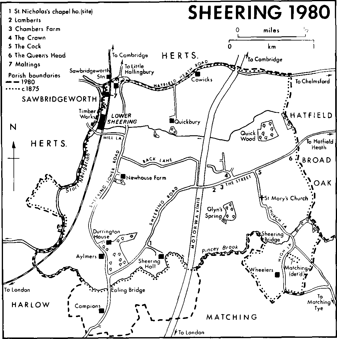
SHEERING 1980
Until the 20th century the main settlement was Sheering village, which extends east and west along the Street, north of the church. (fn. 12) Most of the copyhold tenements which can be located were in the Street, (fn. 13) which in 1769 consisted 'chiefly of mean houses built at a distance from each other'. (fn. 14) It has been suggested that the rectangular ditches there were homestead moats, (fn. 15) but it seems more likely that they were roadside drains. They were apparently extended between 1840 and 1897, and many have been filled in during the 20th century. (fn. 16) In the 18th and early 19th century some outbuildings in the Street were converted into cottages. Development there continued throughout the 19th century, as old houses were divided or replaced, and new ones were built between them. The roadside waste was inclosed, and new building was extended east to the parish boundary. (fn. 17) Replacement and infilling continued in the 20th century, and the number of houses in the Street increased from 66 in 1840 to over 100 in 1980. (fn. 18) Before the Second World War 14 council houses were built in Primley Lane, north of the Street, and 115 more were built between 1950 and 1965 along new roads in the same area. (fn. 19)
There were at least six medieval farmhouses outside the village: Sheering Hall at the south end of Sheering Road, beside Pincey brook; Aylmers and Newhouse in Sheering Lower Road; Quickbury manor and Cowicks south of Hatfield Heath Road; and Wheelers in High Lane, south of Sheering bridge. Newhouse retains some of its medieval structure. The others were later rebuilt. (fn. 20)
In the mid 19th century the building of the railway, across the western side of the parish, stimulated industrial growth at Lower Sheering, near Sawbridgeworth station. (fn. 21) That was not at first accompanied by much residential growth, but by 1921 development had begun in Mill Lane and Lower Road, (fn. 22) and since the Second World War there has been much building between Mill Lane and the railway.
The ancient road pattern, shown on 18thcentury maps, has survived with few changes. (fn. 23) Hatfield Heath Road, which forms part of the northern boundary of the parish, is part of the main road from Sawbridgeworth to Chelmsford. It is joined near Sawbridgeworth station by Lower Road, from Harlow. Sheering Road, which runs south-west in continuation of the Street, joins Lower Road near Pincey brook. Church Lane, leading to Matching, runs southeast from the Street by Sheering bridge to Matching. The line of Lower Road, by Durrington House, was slightly altered in the mid 18th century. (fn. 24) In 1845 Sheering Road, which then passed near Durrington House, was diverted to a more southerly course, farther from the house. (fn. 25) A section of the London-Cambridge motorway, M11, completed in 1980, cuts through the western side of the parish. During its construction Back Lane, which formerly linked Lower Road and the Street, was severed. Its eastern end was sealed off and its western end was diverted southwards to join Sheering Road.
Sheering is approached from the south by two bridges over Pincey brook. Ealing (formerly Gildene) bridge, in Lower Road, recorded from c. 1044, is described elsewhere. (fn. 26) Sheering bridge, in Church Lane, maintained by the parish in the 16th century, became a county bridge in the late 19th century. (fn. 27) A bridge over the Stort was in 1627 the responsibility of the miller of Sheering mill. (fn. 28) It was probably replaced by a new one over the Stort Navigation when that was made in 1769. (fn. 29) The canal bridge was taken over in 1911 by Epping rural district council from the Lee Conservancy. It became a county bridge c. 1929. (fn. 30)
By 1741 Lower Road and Sheering Road were both used by coaches running north and east from Harlow. (fn. 31) In the later 18th century the improvement of the turnpike road from Harlow via Sawbridgeworth and Hockerill (Herts.) probably diverted north-south traffic from Sheering. (fn. 32) In the 1820s and 1830s only the daily coach from London to Dunmow and carriers between Hatfield Broad Oak and London passed through Sheering. (fn. 33) The Northern and Eastern railway from London reached Harlow in 1841 and was extended to Sawbridgeworth and Bishop's Stortford in 1842. (fn. 34) Sheering village is 6 km. northeast of Harlow Mill station and 2 km. south-east of Sawbridgeworth station.
The oldest surviving building, apart from the church, is Newhouse Farm, Lower Road, which retains its late medieval plan of a hall with two cross wings, and has much of the original timberframing, including a crown post roof. A chimney and an upper floor were put into the hall in the early 17th century, and about the same time a service wing was added on the east. Lamberts, in the Street, recorded in 1584, (fn. 35) has a main range and cross wing of the late 16th or early 17th century. Two low pavilions were built on the south front c. 1905 by the novelist Elinor Glyn, who set up her 'Petit Trianon' in the western pavilion. (fn. 36) The pavilions were converted into flats c. 1970. (fn. 37)
Chambers Farm, in the Street, is a 17thcentury timber-framed house, apparently renovated in 1769. (fn. 38) Cowicks, Hatfield Heath Road, probably takes its name from the family of John Cowick, recorded in 1276. (fn. 39) It is a timber-framed building of the 17th century, much altered and enlarged, with maltings at the west end of its service wing. There are traces of a moat to east and west. The manor houses are described below. (fn. 40) Wheelers, High Lane, rebuilt c. 1830, retains part of its medieval moat to the east. It was probably named from the family of John the Wheeler (fl. 1354). (fn. 41)
There were two inns in 1755, the Crown and the Cock. (fn. 42) At that time the Crown may have been the building now called Crown House, the Street, which dates from the 18th century, but by 1809 the sign had been transferred to a house on the present site at the corner of Back Lane and the Street. (fn. 43) The present building may be of 18th-century origin, but was much altered and enlarged in the 19th century. The Cock, also in the Street, is a timber-framed building of 18thcentury origin. The Railway inn, near Sawbridgeworth station, had been built by 1861. (fn. 44) The Queen's Head, in the Street, existed as a beerhouse by 1871. (fn. 45)
Mains water was brought to the parish in 1920, gas in 1933, electricity in 1938, and main drainage in 1953. A village hall, built in the Street in 1930, was burnt down in 1971 and rebuilt in 1974. A playing field, north of the hall, was bought by the parish council in 1921. Another was given to the council in 1966 by Walter Lawrence Ltd. (fn. 46)
Manors.
The Manor Of SHEERING HALL, or lying in the south, was held in 1066 by three men as 5 hides and 30 a., and in 1086 by Peter de Valognes in demesne. (fn. 47) It descended with the honor of Benington or Valognes until that was divided among coheirs in 1235. Sheering then fell to the share of Christine, wife of Peter de Maule. (fn. 48) In 1290 Christine granted the manor to her kinsman Robert FitzWalter, Lord FitzWalter (d. 1326). (fn. 49) FitzWalter in 1294 leased Sheering to Ralph of Coggeshall for two years, and in 1295 confirmed the lease for life. (fn. 50) The lease may have been acquired by Thomas de Lovaine (d. 1345), who in 1314 held the manor in right of his wife Joan (d. 1318). Lovaine presented to the manorial chapel in 1322 and was one of the principal taxpayers in Sheering in 1327. (fn. 51)
Sheering descended like Roydon Hall in the FitzWalter family until 1505. It subsequently remained with the Radcliffes, earls of Sussex, (fn. 52) until 1617, when Robert Radcliffe, earl of Sussex, sold it to Sir Lionel Cranfield, later earl of Middlesex, owner of the adjacent Pishiobury estate in Sawbridgeworth. (fn. 53) Cranfield sold the manor in 1635 to (Sir) Thomas Hewett (Bt.). (fn. 54) Sir Thomas was succeeded in 1662 by his son Sir George Hewett, Bt., later Viscount Hewett, who died unmarried in 1689. Lord Hewett's estates were divided among his four sisters, of whom Elizabeth, wife of Sir Richard Anderson, received most of the Sheering property, comprising 360 a. Lady Anderson, by her will proved 1698, directed that the manor should be sold, and that the proceeds should be put in trust for her husband for life, with reversion to her grandchildren. In 1699 a sale was arranged with Thomas Filmer of the Inner Temple (Mdx.), but both he and Anderson died before the conveyance was completed, and the transaction dragged on until 1706, when the estate passed by Chancery order to Filmer's daughters, Mary and Susan, wife of Robert Eddowes. Mary and Susan sold Sheering in 1718 to Robert Chester, a director of the South Sea Company, who later acquired other property in Sheering that had formed part of the Hewett estate before 1689. (fn. 55)
Robert Chester forfeited his estate as a result of the South Sea Bubble, and Sheering was sold in 1725 to Samuel Feake (d. 1757), chairman of the East India Company. (fn. 56) The manor passed to Samuel Feake (d. 1774), son of the last, whose heirs were his sisters Anne and Mary. Anne Feake married Jonathan Cruse, and died in 1800, leaving her share to him and his heirs, on condition that they took the name of Feake. (fn. 57) He died in 1818 leaving three children by a later marriage: John, Jane, who married Thomas Sanford, and Anne, who married Philip Martin. Mary Feake died unmarried in 1803, leaving her share to Amelia Hollingbury and Amelia's daughter Henrietta, wife of Thomas Glyn. Henrietta was succeeded by her son Thomas C. Glyn (d. 1860) who in 1844 bought the Feakes' share of the manor. Sheering passed to Clayton W. F. Glyn (d. 1887). (fn. 58) His son Clayton L. Glyn lived extravagantly and mortgaged the estate. Durrington House and Sheering Hall had apparently been sold by 1908, when C. L. Glyn was rescued from bankruptcy by his wife Elinor, the novelist. They had lived at Durrington House from their marriage in 1892, moving in 1895 to Sheering Hall and later to Lamberts. He died in 1915, and in 1918 Elinor conveyed the manor to their daughters Margot and Juliet. (fn. 59) The estate was sold and broken up c. 1924. (fn. 60)
Sheering Hall, which was the manor house until the 18th century, stands south of Sheering Road, near Ealing bridge. The site was once moated. (fn. 61) The central section of the south-west front was probably built in the early 17th century. It is timber-framed, jettied along part of each side, and has an unusually high ground floor. There is an 18th-century service wing to the north-east. Two timber-framed, thatched, and weatherboarded barns standing north of the house date from the 17th or the 18th century. (fn. 62)
Durrington House, Lower Road, became the residence of the lord of the manor in the time of Samuel Feake (d. 1757), who remodelled it. (fn. 63) The south range dates from the early 17th century, but appears to have been refaced early in the 18th century. The west range was added in the mid 18th century. It has a fine front with central pediment, canted bays to the ground floor, and recessed Venetian windows to the first floor. The staircase and some service rooms, which occupied the angle between the ranges, appear to have been altered c. 1860 when additions were made on the east side. A small park was formed c. 1845. (fn. 64) Durrington House continued to be the manor house until 1892 or later. (fn. 65) It was the home of Sir Harry Goschen from c. 1906 until his death in 1945. (fn. 66)
The manor of QUICKBURY or COWICKBURY, which lay in the north, was in 1066 held by Alwin Godtuna as 3 hides. In 1086 it was held of William de Warenne by Richard. (fn. 67) The tenancy in chief descended with the earldom of Surrey until 1314, and passed to Aymer de Valence, earl of Pembroke, who died holding it in 1324. (fn. 68) It was held by Edmund, duke of Kent, who was executed in 1330, and descended to Thomas de Holand, earl of Kent (d. 1397). The earldom became extinct in 1408 on the death of Thomas's son Edmund de Holand, and when Thomas's wife Alice died in 1416 her lands were taken into the king's hands. (fn. 69)
In 1098 Richard Guet apparently subinfeudated the manor to Bermondsey priory, later abbey (Surr.). He may have been identical with Richard who was tenant in 1086. (fn. 70) Richard's mesne tenancy passed with Housham in Matching to Ralph de Assartis, who in 1241 confirmed Richard's grant, but changed the terms to tenure in free alms. The abbey's freedom from knight service was later disputed, but was confirmed c. 1257 by Ralph de Arderne and his wife Erneburga. In 1274 the abbey leased Quickbury, along with Monkbury in Little Hallingbury, to Adam de Stratton, the fraudulent chief baron of the Exchequer, who was attainted in 1290. His lands were forfeited to the Crown and in the same year were restored to the abbey. (fn. 71) Bermondsey abbey held Quickbury until the Dissolution.
In 1540 the manor was bought from the Crown by Thomas Josselyn of High Roding. (fn. 72) Josselyn sold it in 1557 to Robert Hurst of Sawbridgeworth. (fn. 73) Hurst was succeeded in 1583 by his brother Roger (d. 1587). (fn. 74) Thomas Hurst, Roger's son, died in 1618, and in 1621 Thomas's son, another Roger, sold the manor to John Poole and his wife Anne. She married Sir John Ramsden in 1633 and William Childers in 1654. In 1657 Childers sold the manor to Abraham Cullen, a London merchant. It passed in succession to Abraham's brothers, Sir John (d. 1677) and Rushout Cullen, who sold it in 1715 to David Petty (fl. 1734), a London merchant. Petty's heir was his daughter Elizabeth. She married George Carpenter, later Lord Carpenter (d. 1748), whose heir was his son George, Lord Carpenter, later earl of Tyrconnell (d. 1762). (fn. 75) George, earl of Tyrconnell (d. 1805), sold the manor c. 1788 to George Parris, whose family had leased it from c. 1745. (fn. 76) Parris still held Quickbury in 1790, but by 1817 it had been sold to the Revd. Thomas Mills. (fn. 77) In 1840 the manor, comprising 328 a., was held by Mrs. Esther Mills. (fn. 78) The Revd. Thomas Mills, son of the previous Thomas, died holding Quickbury in 1857. His heir was his son Thomas Charles Mills. (fn. 79) The lordship remained in the Mills family until the early 20th century. (fn. 80) In 1934 the farm was bought by Robert Watt, whose son of the same name held it as 220 a. in 1980. (fn. 81)
Quickbury manor house lies south of Hatfield Heath Road. It was built in the late 16th or early 17th century, and has a staircase, roof, and doors of the late 17th century. The house was enlarged and cased in brick in the 19th century. There is a 17th-century barn north of the house. (fn. 82)
The manor of SHEERING or HUTTONS or AYLMERS lay in the south-west, near Ealing bridge. It originated as a free tenement of 60 a. which in 1241 was granted by the lords of Sheering Hall manor to Ralph Gobion. Thomas Aylmer, who was holding it in 1427, was succeeded c. 1429 by his infant son William. (fn. 83) In 1465 William Aylmer sold it to Thomas Colte. (fn. 84) It descended in the Colte family with Nether Hall in Roydon until 1606, when George Colte sold it to John and George Kempe. (fn. 85) In 1609 John Kempe sold Aylmers to Lawrence Coldham. It descended to Lawrence's great-grandson Mortlock Coldham, and later passed, in 1777, to Mortlock's great-nephews George Howland and Thomas Paterson. Paterson surrendered his share in 1779 to Howland, who was succeeded c. 1798 by his nephew Sir George Howland Beaumont. In 1805 Beaumont sold Aylmers with 90 a. to Thomas Glyn, joint lord of Sheering Hall manor. (fn. 86) Aylmers passed with the Sheering Hall estate until that was broken up.
Aylmers house stands in Lower Road, on a site which was formerly moated. (fn. 87) It is a timberframed building of the early 17th century, with a central chimney and stair turret. A later 17thcentury service room against the north-west corner probably replaces an earlier building. North of the house is a timber-framed barn, probably of the early 17th century.
Economic History
The Domesday figures suggest that both manors, though small, were economically vigorous. In 1066 and 1086 Sheering manor had five demesne ploughteams and one belonging to the tenants. There were 32 a. of meadow, woodland for 100 swine, and a mill. The recorded population was 14 in 1066 (3 free men, 3 bordars, 8 serfs), and 17 in 1086 (3 villeins, 6 bordars, 8 serfs). There were 8 cows with calves in 1066, but none in 1086; 35 sheep in 1066 and 84 in 1086; 16 swine in 1066 and 56 in 1086; 1 rouncey in 1066 and 2 in 1086, with an ass and a mule. Three hives of bees had been added by 1086. Quickbury manor had two demesne ploughteams, a mill, and 20 a. of meadow at both dates. The recorded population was 12 in 1066 (7 villeins, 5 serfs), and 14 in 1086 (6 villeins, 6 bordars, 2 serfs). By 1086 the tenants' teams had declined from 3½ to 3, the number of sheep had grown from 47 to 52, and there were two colts. (fn. 88) The proportion of bordars and serfs was unusually high for Essex. The increasing number of bordars, sheep, and swine, may well indicate a pioneering enterprise like forest clearance.
In the 14th and 15th centuries the centre of the parish was occupied by open fields, fringed by common meadows along the river Stort to the west and Pincey brook to the south, and woodland on the higher ground to the east and north. The extensive open fields included Malland (Manland, Mallions), between Lower Road and the Stort; Westfield, between Lower and Sheering Roads, Hall and Church commons south of the Street, and Reading common on the eastern boundary. Longlands was between the Street and Back Lane. Primley lay north of Back Lane, and probably adjoined Great Barkfield, which was bounded west by Lower Road. Pincey common was in the south-west corner of the parish. Common meadows included Broadmead, Cowlese, Forelese, Oxlese, and Soggemarsh. (fn. 89) Oxlese probably lay between Pincey brook and Sheering Hall. (fn. 90) The exact location of the other common meadows is not known.
Sheering was less densely wooded in 1086 than most parishes in the hundred. In 1362 Sheering Hall manor contained 20 a. of demesne woodland. (fn. 91) It probably lay east of Sheering Hall, where Woodfield, also 20 a., was recorded in 1840. (fn. 92) Sheering wood, 'the great wood' in 1414, was 'newly cut' in 1431, and by 1464 was pasture. (fn. 93) Quickbury manor had some woodland, though none was recorded in Domesday, for in 1275 a woodward was appointed. (fn. 94) Quick wood, comprising 10 a., still survives near the northeastern boundary of the parish, and is protected by a preservation order of 1950. (fn. 95) North of it, in 1840, lay Little Woodfield. (fn. 96) To the south lay Reading (Reden) common, which seems from its name to have been a forest clearing. (fn. 97) In southwest Essex such areas were usually inclosed after clearance, or became common waste, and it is remarkable that Reading became an open field. In 1279 Christine de Maule was exchanging parcels of land there. (fn. 98)
Inclosure of the open fields proceeded slowly, though it seems to have begun at an early date. Part of Westfield was inclosed when Newhouse farm was established, probably in the later Middle Ages, and by 1775 it had been reduced from 108 a. or more to 36 a. (fn. 99) Much of Aylmers farm had been inclosed by c. 1600. (fn. 100) The prefix 'shet' or 'shut', as in Shet Malland (1742) and Shut Hall field (1840), seems to indicate partial inclosure. (fn. 101) In 1840 there still remained in the parish 125 a. of open fields, lying in Church, Hall, Longlands, Pincey, Primley, Reading, and Mallions commons. By then all the strips in Pincey and Mallions were held by the same man, and many of those in the other commons had also been consolidated. (fn. 102) No commons were recorded in 1865. (fn. 103)
Labour services worth 34s. 8d. were in 1362 being performed on Sheering Hall manor, but paid labour was also being used. (fn. 104) Some summer and winter works were still being performed there in 1431. (fn. 105) The tenants of the manor paid ungeld, a kind of tallage, until 1508 or later. In 1587–8 the copyholders claimed the right to let their houses for three years without licence, and to use timber growing on their lands for house repair. Their letting rights were restricted in 1597, when the manor court forbade copyholders to let houses without licence to persons living outside the manor. At the same time the court resolved to put hedge-breakers in the stocks as well as fining them. (fn. 106) Copyholders' subtenants were apparently identified as hedge-breakers, as they were at Roydon in 1604. (fn. 107) The copyholders of Quickbury in 1583 claimed the rights to have a pound, to let their tenements for three years without licence, and to use timber on their lands for house repairs and firewood. In 1676 they repeated those claims, adding the right to a bull and a boar. (fn. 108)
Christine de Valognes had a warren and a fishery at Sheering Hall by 1275. (fn. 109) In 1519 the lord's fishery was well stocked with pike, and there was also a common fishery. In the 15th century the manor had a dovehouse, and the warren was stocked with hares and rabbits. (fn. 110) There was a fishpond at Quickbury (later Sheering) mill c. 1280. (fn. 111) Quickbury manor had fishponds c. 1650. (fn. 112)
The demesne of Sheering Hall manor in 1362 comprised 354 a. of arable and 20 a. of woodland, but no meadow or pasture. (fn. 113) In 1587 it comprised 276 a. of arable and 97 a. of meadow and pasture. (fn. 114) The whole parish was in 1838 estimated to comprise 1,236 a. of arable, 260 a. of meadow and pasture, and 16 a. of woodland. (fn. 115)
Sheering's malting industry, described below, indicates that barley was an important crop from the late 16th century. Returns of 1866 listed 680 a. of cereals for the parish, mainly wheat and barley. Vegetable crops totalled 258 a., mainly beans and peas. The 1906 returns gave 577 a. of cereals, mainly wheat and oats, and 166 a. of vegetables, mainly beans and mangolds. Those for 1926 listed 521 a. of cereals, mainly wheat and oats, and 120 a. of vegetables, mainly beans, sugar beet, mangolds, and potatoes. (fn. 116) The 1977 returns listed 262 ha. (649 a.) of cereals, mainly barley and wheat. (fn. 117)
There was a hopyard at Cowicks farm in 1601. (fn. 118) In the early 1770s Quickbury manor had an acre of osiers, and in 1792 there was a five-acre field of saffron at Chambers farm, in the Street. (fn. 119) Keith Luxford Ltd., nurserymen, originated c. 1919 when Luxford took over an existing nursery in Back Lane. The firm later moved to Sheering Mill Lane, where a mail order business was established. Chrysanthemums were grown there until 1968. From that year the nursery grew house plants, and in 1980 it had 2 a. under glass. (fn. 120)
Although arable farming seems always to have predominated, sheep farming was important in Sheering by 1377, when 197 fleeces were exported to Hatfield Broad Oak. (fn. 121) Sheering Hall manor contained a sheepcot in 1408. (fn. 122) In 1591 one farmer had 100 sheep. (fn. 123) Among animals listed in 1866 were 175 sheep, 171 pigs, and 103 cattle. In 1906 there were 164 cattle, 37 pigs, but no sheep. The 1926 returns listed 254 cattle, 45 sheep, 51 horses, and 47 pigs. (fn. 124) Those for 1977 listed 715 pigs, 424 cattle, 15,700 poultry, but no sheep. (fn. 125)
In 1840 there were five farms of 50–100a., four of 100–200 a., and two, Quickbury and Sheering Hall, of over 200 a. (fn. 126) A few years earlier Peter Pavitt, then tenant of Sheering Hall, had been commended for good management, and especially for the luxuriance of his arable crops. (fn. 127) In 1977 there were only five farms, apart from smallholdings. Three had between 40 and 50 ha., one between 50 and 100 ha., and one between 100 and 200 ha. (fn. 128)
Sheering Hall water-mill had no stones in 1362. (fn. 129) It was apparently burnt down c. 1401 and later rebuilt, but in 1431 it was ruinous. (fn. 130) Its location is not known. Quickbury water-mill, later called Sheering mill, passed with Quickbury manor to Bermondsey priory, which in 1241 granted privileges there to the mesne lord, Ralph de Assartis. (fn. 131) Later in the 13th century the mill passed to Walter of the mill, who sold it with 2½a. of meadow and its fishpond to Adam de Stratton, lessee of Quickbury, for the large sum of 50 marks. (fn. 132) By 1553 it was a fulling mill. (fn. 133) It may have been converted to fulling soon after 1437, when it was acquired by John Leventhorpe. (fn. 134) He was probably John Leventhorpe (d. 1484), a large sheep farmer at Wennington and Sawbridgeworth. (fn. 135) The fulling mill remained in the Leventhorpe family until it was sold to Daniel Cramphorne c. 1629. Joseph Cramphorne died holding it in 1706. (fn. 136) It was used as a corn mill by James Pynings (1713–34), Andrew Little (1734–75), and in the 1840s by John Barnard, whose family retained it until 1866 or later. (fn. 137) It had been demolished by 1907. (fn. 138) The mill house still stands beside the Stort in Mill Lane. It is a timber-framed building of the 17th century, refronted in the 19th century. (fn. 139)
In the late 16th century £10 4s., more than a tenth, of the rent of Sheering Hall manor was paid in malt. (fn. 140) In 1754 Sheering's output of 7,405 qrs. of malt was second only to that of Saffron Walden among parishes in the area. (fn. 141) A malthouse at Cowicks, owned in 1601 by Thomas Duke, remained in use until 1848 or later. (fn. 142) Seventeenth-century maltings and an 18th-century kiln survived in 1980. By 1601 John Duke had acquired Bushes, Hatfield Heath Road, where he or his successors built Duke's malting. (fn. 143) Richard Godfrey was maltster there in 1734. (fn. 144) By 1861 John Barnard had acquired Duke's malting, and had built two more. (fn. 145) It is not known how long Duke's malting remained in use. In 1876 William Barnard had maltings farther west, near Sawbridgeworth railway station. Barnard & Co. merged in 1886 with H. A. & D. Taylor, and from 1887 traded under Taylor's name. New maltings were added c. 1896, and in 1908 the company built a factory to make malt extract. Taylors were taken over in 1958 by A.B.M. Malting Ltd. In 1980 two of the seven 19th-century maltings were still in use. (fn. 146) Another malting house, at Collins, in the Street, was recorded in 1725 and 1804. (fn. 147)
Walter Lawrence Trading Ltd., door manufacturers, Sheering Mill Lane, originated in 1907, when Walter Lawrence opened joinery works there to serve his Waltham Abbey building firm. In 1972 Lawrence House was built in Sun Lane, off Mill Lane, as the headquarters of the Lawrence group of companies. (fn. 148) F. J. Crow & Sons, Lower Road, builders and sand and ballast hauliers, were established in the 1930s, and Jack White & Co., in the Street, builders' merchants and fencing manufacturers, in 1956. (fn. 149)
Local Government.
It was stated in 1274–5 that Christine de Maule had view of frankpledge and the assize of bread and of ale in Sheering manor, while Bermondsey priory had the same liberties in Quickbury manor, and also claimed bourghselver (tithing money). (fn. 150) The lord of Sheering manor in 1386–7 had the right of gallows. (fn. 151)
Rolls of Sheering Hall courts leet and baron survive for 61 years in the period 1370–1508, and for the years 1558, 1565, 1580, 1584–8, and 1594–1606. There are records of regular courts baron for the periods 1721–3 and 1739–72, and of occasional courts baron between 1784 and 1923, with ten courts leet held between 1776 and 1809. (fn. 152) The leet usually appointed two constables until 1606 or later, and two aletasters until c. 1407. A hayward was occasionally recorded in the Middle Ages. In 1408 two men were elected to the office. The court was mainly concerned with trespass by cattle and pigs, hedge-breaking, drainage, and the maintenance of Ealing bridge. During the 15th century there were a few cases of poaching in the lord's warren and in his fishery.
In the later 13th century, when Adam de Stratton leased Quickbury from Bermondsey priory, a joint court leet was held for that manor and Monkbury in Little Hallingbury. (fn. 153) The surviving rolls of Quickbury record 25 courts between 1546 and 1649. Of those only 10 were courts leet, and none included the election of officers. There are records of a few courts baron for the periods 1692–1753 and 1775–88. (fn. 154) The courts leet were especially concerned with the maintenance of hedges. In the 1580s copyholders' rights were stated, tenants were presented for not wearing caps of English wool according to the statute of 1571, (fn. 155) and three men were presented for not practising at the butts.
Parish vestry minutes survive for the period 1680–1797. (fn. 156) The vestry met once a year, usually at Easter, until 1712, after which it also met regularly in December and held two or three other meetings during the year. The numbers signing the minutes varied between four and ten, headed by the rector or curate when present, and at other times by a churchwarden. Edward Hinton, rector 1712–45, attended regularly between 1719 and 1744. His successors Samuel Payne, 1745–54, and Richard Hinde, 1754–78, often attended.
The vestry appointed two churchwardens, except during the years 1724–64, when there was usually only one, chosen by the rector. A warden usually served for several successive years. There were two overseers of the poor except for the years 1773–9, when there was only one. There is evidence of a rota system for overseers in the years 1715–32, and during that period two widows served, apparently in place of their husbands. The vestry usually appointed two constables until 1735, but later only one. The constable's election was also recorded on the Sheering Hall court rolls between 1776 and 1801. James Cavill, wheelwright, held the office from 1767 to 1801. A salaried vestry clerk was appointed from 1708 or earlier. There were two surveyors of highways.
The annual cost of poor relief rose from £3 11s. in 1682 to £8 15s. 4d. in 1707. In 1715 it reached a peak of £45, and in the 1730s it averaged £50. In 1740 the poor rate reached £64, and in the following year the vestry warned idle youths to find employment. In the early 1780s the average cost of relief was about £170. It was £481 in 1813 and £325 in 1815. There is no record of a poorhouse or workhouse, except in the early 18th century, when Church House seems to have been used for the poor. Outside relief included weekly pensions, boarding allowances, grants of fuel or clothing, apprenticeships for children, and occasional medical care.
Sheering became part of Epping poor law union in 1836. (fn. 157)
Church.
Architectural evidence suggests that there was a church in the 12th century. The advowson of the rectory descended with Sheering Hall manor until 1689. (fn. 158) In 1691 it was divided among Sir George Hewett's four sisters, Arabella, Lady Wiseman, Elizabeth, wife of Sir Richard Anderson, Margaret, wife of Sir Edward Farmer, and Mary, widow of Sir Charles CroftsRead. (fn. 159) They sold it in 1693 to John Hutcher and Richard Harris. (fn. 160) The advowson later passed to Thomas Jordan and his wife, from whom it was bought in 1699 by Christ Church, Oxford, with money left to the college by John Fell (d. 1686), dean and bishop of Oxford. It has remained with Christ Church since then. (fn. 161)
The rectory was valued at 15 marks in 1254, when Bermondsey priory retained the small tithes from the demesne of Quickbury, and £6 13s. 4d. in 1291, when Bermondsey's portion was £2. (fn. 162) The value of the rectory was £13 13s. 4d. in 1535, and £80 in 1650. (fn. 163) Tithes were a source of dispute between Leonard Solme, rector 1572–1613, and his parishioners. (fn. 164) There were further disputes in the 1750s when Richard Hinde, rector 1754–78, tried to extort higher tithe payments. (fn. 165) The tithes were commuted in 1840 for £509. (fn. 166) There were some 26 a. of glebe in 1650, and 23 a. in 1840. (fn. 167) Parts of the glebe were used to extend the churchyard in 1867 and 1917. (fn. 168) In 1956 only 10 a. of glebe remained. (fn. 169)
The Rectory house, south of the church, was sold in 1952, when a new Rectory was built on the glebe, north of the church. (fn. 170) The Old Rectory contains 17th-century fragments in the timberframed walling in the kitchen and in a chimney on the south front. The south-west corner of the house was remodelled c. 1770 by the rector, Richard Hinde. (fn. 171) Edward Brown, rector 1824– 44, refronted the house and added spacious rooms at the east end in Tudor Gothic style: between 1835 and 1837 he spent £1,000 on the house. (fn. 172)
Rectors' names are recorded from 1316. (fn. 173) During the Middle Ages few remained for more than five years. From the mid 15th century many of them were pluralists. Among those was Leonard Solme, who was said c. 1585 to be a 'hunter and gamester' who did not preach, and Stephen Withers, rector from 1613. (fn. 174) Withers, a fervent Royalist, was sequestrated in 1643 and was imprisoned. (fn. 175) John Ward, who was instituted c. 1649, after Withers's death, conformed in 1662. Edward Hinton, rector 1712–45, Samuel Payne, 1745–54, and Richard Hinde, 1754–78, were all resident. (fn. 176) Francis Tutte, 1778–1824, was in 1796 granted a dispensation, on strict conditions, to hold Sheering in plurality with Henham. (fn. 177) For much of his long incumbency Sheering seems to have been served by curates. (fn. 178)
The church of ST. MARY THE VIRGIN is built of flint rubble with some Roman and early medieval brick. It has a chancel with north vestry and organ chamber, nave with north aisle, south porch, and embattled west tower with pyramidal roof. Fragments of 12th-century diaper work formerly noted in the church suggest that the church already existed then. (fn. 179) The tower and the west wall of the nave date from the late 13th century. The nave and chancel were largely rebuilt in the late 14th century, when the twostoreyed north vestry and the south porch were added. The chancel roof and the brick parapet of the tower are probably of the 16th century. A timber staircase was put into the tower in the 17th century.
In 1855 the church was restored and fitted with open pews. (fn. 180) A further restoration was carried out c. 1875, when a triple chancel arch was built. (fn. 181) Herbert Williams, rector 1900–36, in 1903 added the north aisle and organ chamber, designed by G. E. Pritchett, as a memorial to Canon Edward Hill, rector 1849–1900. At the same time two galleries were removed from the nave. (fn. 182) The south porch was restored in 1905 and the tower in 1906. (fn. 183) The east window tracery contains 14th-century glass depicting the coronation of the Virgin. (fn. 184) A window in the tower, designed by John Hayward in 1974, portrays St. Nicholas, to whom the free chapel (below) was dedicated. The 12th-century font, formerly in pieces, has been restored. The rector's stall, repaired and replaced in the chancel c. 1924, has carved and painted heads of c. 1400 on the arms. It was one of a number of similar stalls noted in the church c. 1710. (fn. 185)
There are four bells, including two of 1619. (fn. 186) The plate includes a silver cup and paten of 1561. (fn. 187) There is a brass to Robert Hurst (d. 1583), and an armorial marble floor slab to Richard Sayer (d. 1711), rector, and his wife.
Church House, adjoining the church, is said to have been given as an endowment for church repairs. In 1713 it was let to the parish overseers for 6s. 8d. a year, probably as a poorhouse. From c. 1725 the rent of £1 6s. 8d. was paid to the vestry clerk. In 1734 the vestry proposed to move the house to a more convenient site. (fn. 188) No more is known of it.
The free chapel of ST. NICHOLAS, which stood in the courtyard of Sheering Hall, was founded in 1275 by Christine de Maule, lady of the manor, who endowed it with a house, 42 a. of land, and 5s. annual rent in Sheering, and £11 6s. 8d. annual rent from lands in Norfolk, to maintain two chaplains. The house, which was moated and had a grove of trees, stood 200 m. north-west of Sheering Hall. (fn. 189) The advowson of the chapel passed with Sheering Hall manor. (fn. 190) There seems usually to have been only one chaplain. (fn. 191) In 1535 the chapel was valued at £4 13s. 4d. a year. (fn. 192) By 1548, when it was dissolved, it was said to be worth only 42s. a year. (fn. 193) The chapel was granted in that year to Walter Farr and Ralph Standish. (fn. 194) The chapel and the house have not survived, but the rectangular moat remains.
Nonconformity
In 1709 the house of Henry Hank was licensed for Baptist meetings. (fn. 195) Later in the 18th century Sheering Baptists probably attended Fore Street chapel, Harlow, as the Hank family did in 1765. (fn. 196) An evangelist, the Revd. Samuel Organe, who in 1886 was living at Crown House, in the Street, may have been connected with the cottage mission started before 1890, apparently by Methodists. (fn. 197) In 1891 the North West Essex Methodists mission bought a wooden chapel, probably to replace the cottage, and in 1901 bought four cottages in Sheering. (fn. 198) The mission survived in 1911 and there was a mission room in the Street until 1915 or later. (fn. 199)
Education.
Sheering Church of England primary school, in the Street, appears to have originated in 1816, when the rector, Francis Tutte, gave £100 in trust to teach 12 poor girls of Sheering to read, spell, and sew. (fn. 200) In 1819 a school with 16 girls was being maintained by Tutte's gift and subscriptions. (fn. 201) By 1827 it was a National day and Sunday school with 15 boys and 35 girls. (fn. 202) In 1835 the annual income of £3 13s. 6d. from Tutte's gift was being paid to the schoolmistress. Of 45 children who were then being taught free 30 were girls, more than 12 of whom were nominated by the rector. (fn. 203) About 1851 a new National school for 54 children was built in the Street. (fn. 204) It was enlarged in 1874 and received annual government grants from 1880. (fn. 205) The school was damaged by bombing in 1941. (fn. 206) In 1954 it was reorganized for juniors and infants, and was granted Controlled status. (fn. 207) It was enlarged in 1966. (fn. 208) By a Board of Education order of 1905 the income of £2 12s. 4d. from Tutte's gift was to provide prizes for girls proficient in needlework and religious knowledge. (fn. 209) Nothing was known of the charity in 1979. Sheering has benefited from Fawbert and Barnard's school, Harlow, founded in 1836, and the Tom Parkin educational charity, Harlow, founded in 1977. (fn. 210)
Charities for the Poor.
There are no surviving charities for the poor. It was said c. 1680 that land in Hall Common field was charged with 6s. 8d. rent for the poor, and attempts were to be made to trace its origin. In the 18th century the income was being received regularly, and it was used to give firewood to the poor until 1797 or later. (fn. 211) No more is known of it.