A History of the County of Gloucester: Volume 12. Originally published by Boydell & Brewer for Victoria County History, Woodbridge, 2010.
This free content was digitised by double rekeying. All rights reserved.
'Newent and May Hill', in A History of the County of Gloucester: Volume 12, ed. A.R.J. Jurica( Woodbridge, 2010), British History Online https://www.british-history.ac.uk/vch/glos/vol12/1-6 [accessed 27 July 2024].
'Newent and May Hill', in A History of the County of Gloucester: Volume 12. Edited by A.R.J. Jurica( Woodbridge, 2010), British History Online, accessed July 27, 2024, https://www.british-history.ac.uk/vch/glos/vol12/1-6.
"Newent and May Hill". A History of the County of Gloucester: Volume 12. Ed. A.R.J. Jurica(Woodbridge, 2010), , British History Online. Web. 27 July 2024. https://www.british-history.ac.uk/vch/glos/vol12/1-6.
In this section
NEWENT AND MAY HILL
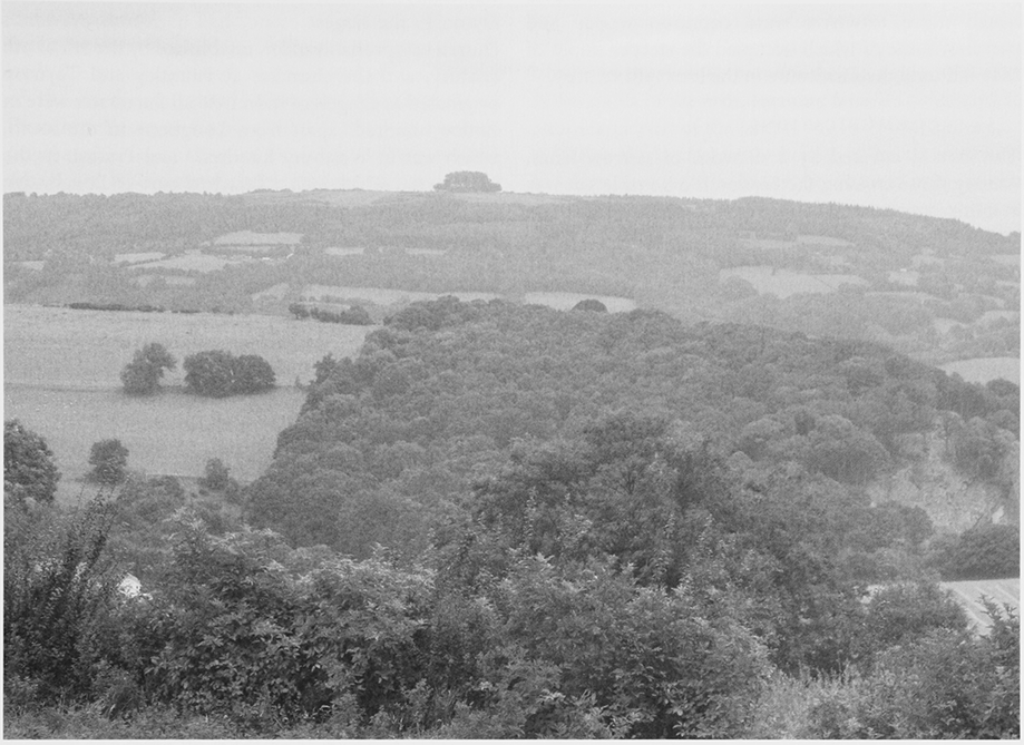
1. May hill: view from the south-west at the Wilderness, Mitcheldean
THIS volume of the county history covers an area in the north-west corner of Gloucestershire adjoining the ancient counties of Hereford and Worcester. The area, a belt of land extending northwards to the county boundary with the town of Newent at its centre, contained ten ancient parishes, namely Bromesberrow, Dymock, Huntley, Kempley, Longhope, Newent, Oxenhall, Pauntley, Preston, and Taynton. The whole of each parish is treated here. The area's identity has been shaped by its proximity to the Forest of Dean and in its physical characteristics has affinities with south Herefordshire.
TOPOGRAPHY
In a rolling landscape streams form tributaries of the river Leadon that on its winding course towards the river Severn passes through a ravine marking the county's ancient boundary with Worcestershire. (fn. 1) Away from the Leadon the hills are steeper and the northern end of the area rises on foothills of the Malverns. To the south the landscape is dominated by May hill, an eminence formerly known as Yartleton hill (fn. 2) that is partly in Herefordshire and is crowned by trees at 296 m. (fn. 3) The valley of the Longhope brook to its south-west drains southwards towards the Severn.
The area has substantial tracts of woodland including ancient woods and plantations created between the 18th and 20th centuries. The older woods are vestiges of expanses of wooded and waste land, which on the hilly northern end in Bromesberrow was within the medieval Malvern Chase. The whole of the southern half of the area up to Newent was for a time until the early 14th century within the jurisdiction of the Forest of Dean. (fn. 4) Over much of the area a pattern of small hedged fields and scattered farmsteads emerged from the clearance of the ancient woodland, a process well advanced by the late Anglo-Saxon period. Open fields never occupied more than a small area on some of the less hilly land and most were inclosed early in a piecemeal process and converted to pasture and orchard. Much more extensive were common woods and pastures, some of which occupied the steeper slopes of May hill until their inclosure in the later 19th century.
COMMUNICATIONS
The area is covered by a network of narrow lanes. Among those crossing the Leadon is a possible salt way running southwards from Worcestershire. The main roads are routes from Gloucester that fan out west of the Severn towards South Wales and Herefordshire and are based in part on Roman roads. In the coaching era roads forked in the south, in Huntley, for Monmouth and for Hereford, the latter route crossing the south side of May hill towards Ross-on-Wye (Herefs.). Another route to Hereford passed north of the hill by way of Newent. In the north a road from Gloucester passing through Bromesberrow on an Anglo-Saxon route was one of several roads converging on Ledbury (Herefs.). Despite the turnpiking of some of the principal roads the countryside between Newent town and the county boundary remained relatively inaccessible in the later 18th century. (fn. 5) In the early 19th century the major routes were altered in places to mitigate the steepness of their gradients and other improvements in the turnpike era included the building of a new way into Herefordshire beyond Dymock in the 1830s. The M50 motorway, opened in 1960 across the northern end of the area, has a junction with the Gloucester–Ledbury road within Bromesberrow.
The Hereford and Gloucester canal leading from the Severn at Gloucester opened across the area in 1798 on its completion as far as Ledbury. Passing near Newent town, it ran through a tunnel between Oxenhall and Dymock and in the north it closely followed the course of the Leadon. It closed in 1881 to be replaced by a railway opened between Gloucester and Ledbury in 1885. Another branch railway running through the area, the Gloucester and Hereford line up the Longhope valley, had been finished in 1855. Both railways closed in 1964 and part of the track of the Ledbury line was adapted as a road bypassing Newent town.
SETTLEMENT, SOCIETY, AND BUILDINGS
The greatest concentration of known sites from the Romano-British period within the area is in Dymock. In the late Anglo-Saxon period there were extensive adjacent royal estates at Dymock and Newent, the latter an outpost of that at Westbury-on-Severn. In addition in 1066 King Harold was lord of Bromesberrow and Oxenhall and thegns were in possession of Longhope (then called Hope) and possibly of other estates such as Carswalls, Huntley, Kempley, and Oxenhall. While Dymock, the largest estate, had a church, Newent's church was probably older, established by the 8th or 9th century, and the churches at Pauntley and Taynton originated as chapels of it. In 1086 all the estates were in Botloe hundred (fn. 6) apart from Longhope in the south, which was in Westbury hundred, (fn. 7) and Preston in the north-west, which was a detached part of Longbridge hundred, (fn. 8) itself perhaps created out of Botloe. (fn. 9) The estates were all to form separate parishes apart from two estates at Taynton, which made a single parish, from Carswalls and Hege (identified as Hayes), which were taken into Newent parish, and from Ketford and Kilcot, which belonged to Pauntley parish, Kilcot as a detached part. (fn. 10)
At the time of Domesday Book, when most arable land was in tenant holdings rather than in demesne, probably only Dymock and Newent had villages as their primary settlements. Most settlement was in solitary farmsteads and many of the tenants, usually villans, were the precursors of later yeomen who occupied scattered freehold and copyhold farms throughout the area. The building of farmsteads on cleared land continued after the Norman Conquest, when new settlement also included a substantial earthwork in Taynton, but with the consolidation of farms from the later Middle Ages numerous farmhouses and farmsteads were abandoned. Despite moves in the 13th century to foster trade on the royal manor of Dymock the only market centre to emerge was at Newent. In the 18th and 19th centuries squatter settlement on common and waste land created a number of hamlets, as on May hill and at Gorsley on the Herefordshire border, (fn. 11) and road improvements facilitated the growth of villages in Huntley, Kempley, and Longhope. Increased residential development in the later 20th century centred on Newent town, which expanded into the surrounding fields, and led to hamlets such as Bromesberrow Heath, Clifford's Mesne, and May Hill despite their irregular road patterns becoming regarded as villages.
At the Norman Conquest Dymock and Newent, the largest parishes, remained largely royal territory and Preston, the smallest, belonged to Gloucester abbey. Newent passed to Cormeilles abbey (Eure), which established a priory there, and in the 12th century the larger estate at Dymock was broken up, part of it passing to the local Cistercian house at Flaxley. While several other religious houses and hospitals acquired bits of land in the area, in Kempley including St Katherine's hospital at Ledbury, most of the land remained in lay hands. Prominent baronial families with manors in the area and almost invariably nonresident included the Lacys and the lords of Monmouth and Kilpeck (Herefs.) and later the Greys of Wilton, in Bridstow (Herefs.), and the Talbots. Among smaller lay lords the most prominent and the wealthiest at the end of the medieval period were the Whittingtons of Pauntley. Yeoman families with farms that perhaps originated in the holdings of Domesday tenants became significant landowners in the manors, occupying the medieval farmsteads scattered throughout the area.
From the 16th century, save for Preston which passed to the bishops of Gloucester, the parishes contained few big estates, most of their land belonging to gentry and yeomen. The property of Cormeilles abbey, which Fotheringhay college (Northants.) had owned from the early 15th century until its surrender to the Crown, came to the Winters of Lydney. Destruction during the Civil War included the sacking of Taynton church (fn. 12) and there were minor military engagements after the siege of Gloucester was lifted in 1643 and the area west of the Severn was filled with opposing garrisons. (fn. 13) Landowners and farmers incurred financial damage by giving free quarter to both sides in the conflict. (fn. 14) After hostilities ceased leading royalists, notably Sir John Somerset at Pauntley, suffered financial penalties but there was no great transfer of land, apart from sales of property in Dymock and Newent by Sir John Winter, the chief supporter of the Crown in the Forest of Dean area.
From the mid 17th century the Foleys, a dynasty of ironmasters, were among the leading landowners, particularly in Newent and Oxenhall. Among the resident gentry the Wynniatts and Cams of Dymock were families that had prospered locally as yeomen. The Pyndars, who came to Kempley from Derbyshire in the later 17th century, changed their name to Lygon and moved to Madresfield (Worcs.) on inheriting an estate there in the mid 18th. Substantial yeoman families remained the backbone of local society, notably the Hookes in Pauntley, the Hills in and around Dymock and Newent, and from the 17th century the Holders in Taynton. With the non-residence of its more substantial landowners, of whom the Roman Catholic Somersets abandoned the enlargement of their house at Pauntley Court in the later 17th century, and the absence of large estates the area has few grand houses. Bromesberrow Place, the principal exception, standing in the north-east on the former county boundary, was enlarged in the later 18th century for the Yate family. In the 19th and early 20th century most of the area's major landowners were resident, among them the Onslows, the Foleys' successors, in Newent, the Thackwells and Drummonds (later Deane-Drummonds) in Dymock, and the Ricardos in Bromesberrow. The Probyns of Newland built a modest country house in Longhope but they later occupied Huntley Manor and sold most of their land in the later 19th century to the Ackers family, which thereby became the dominant influence in the south of the area. Farming families continued to own a large part of the land in the early 21st century.
Within the landscape the houses of the yeomanry are an ubiquitous feature. Many are situated on a hillside or an outcrop, having complex sections with wings at different levels (Winter's Farm; Russell's End) and ancillary buildings on separate terraces (Byfords; Kew's Farm). Some on flatter land stand within or next to moats (Bellamy's Farm; the Moat; Taynton Court). Many houses date from the 16th and 17th centuries but among survivals of late medieval architecture Toney's Farm, one of several early stone-built houses at the foot of the Malvern hills, and Crooke's Farm have elaborate roofs. The remains of several jettied houses form part of the building stock of Newent town.
In the modern period some manor houses and farmhouses evolved into small country houses. One of the earliest is Preston Court, a large timber-framed house of the late 16th or early 17th century. Local stone, used for plinths, gable walls, and chimneys, was occasionally employed for entire houses such as an early 17th-century manor house (Stone House) in Kempley. While new building in the later 17th and early 18th century included fashionable houses such as Kempley Court, Hart's Barn, Boyce Court, Hownhall Farm, Briery Hill, and, in Newent town, the Tan House, the adoption of brick for outer walls rather than just for the infill of timber frames was gradual. The technique of building entirely in brick reputedly became standard practice for smart houses in Newent town at the very end of the 17th century (fn. 15) but it was used earlier, as at Huntley Court, and it was extended in the 1690s to a collection of outbuildings at Taynton House. Light timber framing continued to be used in the construction of humbler houses in the 18th century. Cider houses from the period survive in many of the farmyards and several retain mill machinery.
In the 19th century roadside villas were built in the countryside and the remodelling and enlargement of main houses such as Taynton House and Boyce Court continued. One entirely new country house, Clifford Manor, was built on the lower slopes of May hill. Farm buildings were also improved, in the early years in Oxenhall and Newent and latterly in Dymock and Kempley, where the Madresfield estate provided new houses, outbuildings, and cottages. In Huntley, where a model farmstead at Woodend was among buildings erected for the Probyns in the 1850s, the rector Daniel Capper rebuilt the church and parsonage (later Huntley Manor) in the early 1860s. In the 20th century, particularly after the sale of their land, many farmhouses were modernized and their outbuildings converted as dwellings.
In church architecture Dymock, dating from the late 11th century, is by far the largest in a local group of early Norman churches with decoration ascribed to a 'Dymock school' of sculptors. (fn. 16) Kempley's 12th-century church is virtually complete, retaining its nave roof and much of its wall decoration. Medieval additions to the area's churches were modest, except perhaps at Newent, and 19th-century restorations were usually pedestrian. Notable individual buildings are a mid 17th-century church aligned north–south at Taynton, a late 17th-century nave at Newent constructed primarily as a self-contained auditorium, an ornate Victorian church by S.S. Teulon at Huntley, and an 'Arts and Crafts' church of 1903 by A. Randall Wells at Kempley. The last is a reminder of the High Churchmanship of the Lygons (Earls Beauchamp), the imposition of which provided a challenge to the religious traditions and practice in Dymock and Kempley in the later 19th century. In the course of the 19th century nonconformists built a few, small chapels and from the 1860s Anglicans provided places of worship for growing settlements at Bromesberrow Heath, Clifford's Mesne, and Gorsley.
ECONOMY
In an area often devoted primarily to dairying and cattle and sheep rearing, the lighter and friable sandy soils of the north were used primarily for growing rye in the Middle Ages. The countryside extending deep into Herefordshire became known as 'the ryelands' and, more particularly, a division of Dymock took its name from the cultivation of rye. (fn. 17) The Ryeland breed of sheep, reared for meat and wool, was named from the area. (fn. 18) Agricultural improvements were often delayed in the 18th century and despite a decline in the cultivation of rye well over half of the crop returned in Gloucestershire in 1801 was grown in Bromesberrow, Dymock, and Newent. (fn. 19) There were numerous apple and pear orchards in the mid 16th century and the countryside was likened in the later 18th century to a garden overspread in spring with flowers and to a forest of fruit trees. (fn. 20) The ryelands were particularly suitable for cider apples (fn. 21) and the area around Dymock became noted for the quality of its drink made from the Red Streak variety, (fn. 22) said to have been introduced to England from France by John Scudamore, Viscount Scudamore, of Holme Lacy (Herefs.) in the late 1630s. (fn. 23) Taynton, which was associated with a variety of squash pear by the 1670s, (fn. 24) was esteemed for its cider and perry in the later 18th century (fn. 25) and Huntley, Kempley, and Newent had businesses producing cider and perry until well into the 20th century. In the later 20th century viniculture was established in several places. The area's role in soft fruit and market-garden cultivation developed in the 20th century, notably through a scheme applied to a Newent estate in the 1930s. A long celebrated feature of the area's natural flora are the daffodils that flower in its lanes and fields in the spring.
With its weekly market, a right granted to Cormeilles abbey in 1253, the town of Newent became the area's principal trading centre. The market dealt in corn and Welsh cattle at the start and a market house built in 1668 was used for sales of butter. Annual fairs came to deal mainly in livestock and cheese. From the Middle Ages the town's inhabitants were predominantly tradesmen and craftsmen supplying goods to the surrounding villages. Cloth making continued in the town into the early modern period and leather tanning was an important industry there in the 17th century. With the discovery of coal deposits close by and the building of the canal from Gloucester the town's economic prospects looked promising in the later 18th century. A small spa was also developed but the various initiatives failed to prosper. While the poor state of many local roads had offered some protection to its trade, road improvements from the early 19th century increasingly drew Newent into the economic orbit of the county town, and regional centre, of Gloucester. Newent's market business ceased in the mid 20th century but its onion fair was revived later as a pleasure fair.
Industrial activity was based on the area's mineral resources and woodland. French immigrants operated a glassworks near the foot of May hill for a few decades from the late 16th century. In the 17th century blast furnaces in Longhope and elsewhere smelted locallymined ore and cinders, the latter being the iron-rich slag produced and deposited, often in large tips, during earlier iron-ore working. All the ironworks within the area were short-lived apart from the Ellbridge furnace, north of Newent town, which was taken over by the Foley family, the main players in the industry. It remained in production until the mid 18th century and the building thought to have been its charcoal store is one of the most significant reminders of the area's past industry. (fn. 26) Mining within the Newent coalfield was only sporadic despite the coalfield's development being one of the principal objects for the construction of the Hereford and Gloucester canal. Quarrying of stone took place throughout the area, notably on the sides of May hill where substantial quarries were worked periodically in the 18th and 19th centuries. In the same period brickworks in Kempley, Newent, and Taynton supplied the needs of local builders and gardeners.
Coppicing for charcoal production, an early feature of the woodland economy, intensified in the 17th and 18th centuries to satisfy the requirements of ironworks within and beyond the area. The Foleys bought a number of woods to secure charcoal supplies and the Probyns were among landowners establishing new plantations. During the same period oak bark was regularly harvested for tanning purposes. Other woodland crafts used the small wood to make products such as handles, hoops, and laths and the most successful business in that field, the turnery established in Longhope by the Constance family in the later 18th century, survived until the early 1980s. During the 20th century deciduous woodland gave way to conifer plantations, one of the agents in the change in timber production being the Forestry Commission, which took over the commercial management of a number of woods, including those in the west known collectively as Dymock Woods. In the south C.P. Ackers (d. 1960) increased the woodland on his Huntley estate and businesses he fostered to make woodland products and provide advice on woodland management continued in the early 21st century.
Tradesmen moving goods along the roads into Herefordshire and South Wales included in the early 17th century a carrier operating in London from the south of the area at Longhope. Residents on the duchy of Lancaster manor there could obtain exemption from fair and market tolls in England. (fn. 27) Local carriers and hauliers continued to serve the agricultural economy in the era of motorised transport, one of the more successful businesses being founded at Longhope by Henry Read in the 1920s. From the mid 20th century the area became increasingly a dormitory for Gloucester and other large towns. Several small business parks were established to provide manufacturing and service jobs within the area and in the early 21st century Newent town retained a role as a centre for shopping, professional services, and schools.
ADMINISTRATION
Hundredal rights in Botloe remained with the Crown (fn. 28) but about half of the parishes and tithings obtained total or partial exemption from the jurisdiction of the hundred court. In Newent, where Cormeilles abbey enjoyed extensive franchises including view of frankpledge by the 13th century and granted liberties piecemeal to the inhabitants of the town, the supremacy of the abbey's manor court was confirmed in 1297. A separate town court was held until at least the late 15th century and there were also lesser courts for other manors. The roof of Newent's former boothall, probably its early court and market house, is an elaborate and rare example from a late medieval town building. In Dymock the lords of the manor held a view of frankpledge for the whole parish apart from the estate of Flaxley abbey. The two lords of Taynton probably held their own views by the later 13th century; in 1287 Cecily de Mucegros claimed that right in Great Taynton and Bevis de Knovill asserted his entitlement to a number of franchises in Little Taynton. (fn. 29) Tithingmen for Bromesberrow, Kempley, Oxenhall, and Pauntley were answerable in the hundred view of frankpledge according to records of the years 1641–5; (fn. 30) the sheriff or his deputy held that view in the later 18th century. (fn. 31)
The ties of Huntley and Longhope with their respective hundreds were loosened in the later Middle Ages, probably in the 15th century. The manor courts in both places, which had become estates of the duchy of Lancaster and were eventually to form part of a new hundred made up of duchy estates, (fn. 32) exercised leet jurisdiction in the early modern period. Preston, where Gloucester abbey had leet jurisdiction in the early 16th century, belonged between 1483 and 1662, through the addition of Longbridge hundred to Dudstone and King's Barton hundred, (fn. 33) to a separate county, the inshire, administered by Gloucester corporation. (fn. 34)
Botloe's historic meeting place was a green at its centre high above the Leadon on the boundary between Newent and Pauntley, (fn. 35) but the mound represented in the second element of its name is possibly the earthwork at Castle Tump, 1.6 km to the north-west at the limits of Dymock, Newent, Oxenhall, and Pauntley. (fn. 36) It has been postulated that the road running west of the mound represents a Roman route from Gloucester. (fn. 37) In the mid 17th century the hundred court met further south at Ell bridge, (fn. 38) where the same road crossed a tributary of the Leadon near Newent town.
In 1835 Newent became the centre of a poor-law union made up of 18 parishes, including Aston Ingham and Linton in Herefordshire and Redmarley D'Abitot and Staunton in Worcestershire. (fn. 39) The town continued to have a role in the government of a wide area until 1974, from 1895 as the centre of a rural district that comprised the union's Gloucestershire parishes. Its two Worcestershire parishes technically formed a separate rural district (fn. 40) until they were added to Gloucestershire in 1931. (fn. 41) Huntley and Longhope, the two southernmost parishes in this volume, became part of the Westbury-on-Severn poor-law union in 1835 (fn. 42) and thus belonged from 1895 to East Dean and United Parishes Rural District, (fn. 43) reorganised in 1935 as East Dean Rural District. (fn. 44) From 1974 all of the area in the volume was within Forest of Dean District.