A History of the County of Gloucester: Volume 12. Originally published by Boydell & Brewer for Victoria County History, Woodbridge, 2010.
This free content was digitised by double rekeying. All rights reserved.
'Bromesberrow', in A History of the County of Gloucester: Volume 12, ed. A.R.J. Jurica (Woodbridge, 2010), British History Online https://www.british-history.ac.uk/vch/glos/vol12/95-122 [accessed 30 April 2025].
'Bromesberrow', in A History of the County of Gloucester: Volume 12. Edited by A.R.J. Jurica (Woodbridge, 2010), British History Online, accessed April 30, 2025, https://www.british-history.ac.uk/vch/glos/vol12/95-122.
"Bromesberrow". A History of the County of Gloucester: Volume 12. Ed. A.R.J. Jurica (Woodbridge, 2010), British History Online. Web. 30 April 2025. https://www.british-history.ac.uk/vch/glos/vol12/95-122.
In this section
BROMESBERROW
Map 7. Bromesberrow 1882
BROMESBERROW is a small rural parish 18 km NNW of Gloucester and 5 km south-east of Ledbury (Herefs.). Situated at the southern tip of the Malvern hills, the ancient parish was bordered by Herefordshire to the north and west and Worcestershire to the east. Before disafforestation in the 17th century part of the parish lay within Malvern Chase (fn. 1) and the lord of Bromesberrow was expected to attend the chase court at Hanley Castle (Worcs.). (fn. 2) The parish boundaries, which enclosed 1,809 a. (732 ha), (fn. 3) remained the same until 1992, when Bromesberrow gained land from Redmarley D'Abitot (Glos., formerly Worcs.) to the east and its boundary on the south-west was moved to the line of the M50 motorway to take the village of Bromesberrow Heath from Dymock. (fn. 4)
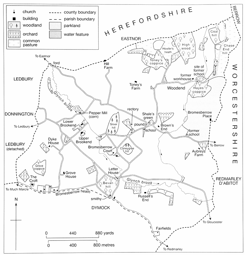
25. Bromesberrow: view from the south-west showing the church and Coneygree hill
LANDSCAPE
The landscape of Bromesberrow, included within the Malvern Hills Area of Outstanding Natural Beauty in 1959, (fn. 5) is well wooded and rises steeply from Toney's Farm (80 m) to Howler's heath (180 m). Chase End hill (191 m) (fn. 6) in the north-east of the parish, called wærlafes dune ('Wærlaf's hill') in the 10th century, (fn. 7) is the southernmost of the Malvern hills and is formed from a mixture of Precambrian igneous rocks and Cambrian shale. Howler's heath, recorded in the early 14th century, (fn. 8) lies on Silurian May Hill (Llandovery) sandstone, (fn. 9) which was quarried there for building stone. (fn. 10)
South of Toney's Farm the relief is gentler, typically between 50 and 75 m, and the Glynch brook crosses the parish from north-west to south-east. On the east side a small stream rising in Eastnor (Herefs.) runs north–south through Woodend to join the brook south of Aubreys Farm. In the centre of the parish, close to its church, two prominent rounded hills have given rise to place names in Old English beorg. (fn. 11) Coneygree hill, probably the mound from which Bromesberrow took its name, (fn. 12) was a rabbit warren (le Conynger) in 1393 (fn. 13) and was landscaped in the 18th century in an aborted attempt to build a new manor house on its summit. (fn. 14) Bevan hill, rising south of the Glynch brook and east of Bromesberrow heath, was recorded in 1369. (fn. 15) Much of the land in the south of the parish is formed from Permian Bridgnorth and Triassic Bromsgrove sandstones, giving light and well-drained soils red in colour, although Dyke House (86 m) in the southwest stands on a patch of boulder clay. (fn. 16)
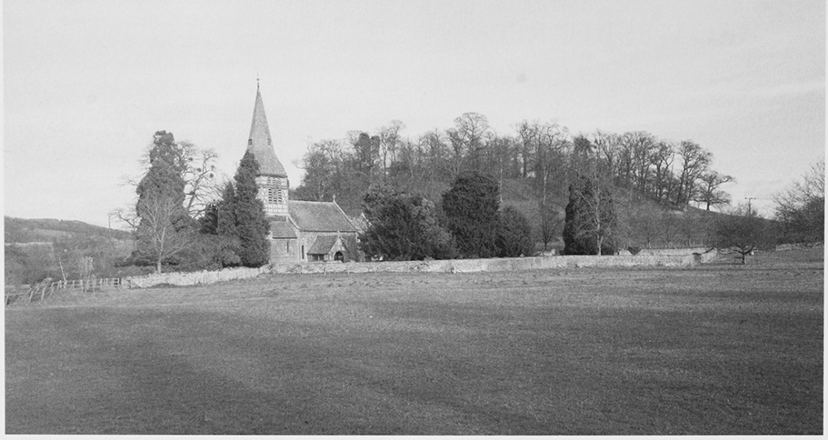
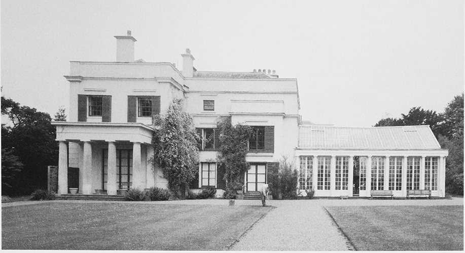
26. Bromesberrow Place from the west c. 1800
In 1086 Bromesberrow had woodland measuring 2 by 1 leagues. (fn. 17) Early woods mentioned in the parish included High wood (Overwode), Hayes' coppice (le hey), and Bernewode near Toney's Farm. (fn. 18) The name Whiteleaved Oak, associated with the meeting-point of the three counties at the north-east corner of Bromesberrow, referred in 1584 to a great tree that was a landmark on the boundary of Malvern Chase. (fn. 19) The light sandy soils covering much of the parish are generally poor and historically were used for growing rye, although numerous orchards are recorded from the late 16th century and fertile river meadows line the Glynch brook and its tributary through Woodend. The extent and number of Bromesberrow's medieval open fields are not known and most arable farming in the parish appears to have taken place in small closes. Inclosure seems to have been a long and informal process that was largely complete by the early 19th century. Bromesberrow heath, the greater part of which belonged to Dymock, was inclosed under awards dated 1864 and 1866, (fn. 20) but Howler's heath, recorded as Oulithe ('owl's slope') in the 14th century, (fn. 21) and much of Chase End hill remained common land in 2007. (fn. 22)
Following the building of Bromesberrow Place on the eastern boundary in the later 18th century a park containing several plantations and a fishing lake was created around the house; (fn. 23) a boat house had been erected beside the lake by 1903. (fn. 24) In the late 20th century a new park, designed by Hal Moggridge, was laid out to the west of the existing one and shelter belts of trees were planted around the fringes of the parkland. A reservoir was created to the north of the fishing lake in the 1980s. (fn. 25) In 1905 Malvern Urban District Council began pumping water from a well west of Bevan hill (fn. 26) and under an agreement of 1908 with Newent Rural District Council it provided a free supply to some Bromesberrow residents. (fn. 27)
ROADS
Bromesberrow is crossed by a network of minor lanes and paths, several of which have formed deep hollow ways. (fn. 28) Many of Bromesberrow's farmsteads can only be reached along narrow dead-end lanes, but it is likely that the settlements around the church and at Brookend stand on a former route to Ledbury along the Glynch brook, perhaps the highway referred to in the 13th century. (fn. 29) Among the lanes converging on a small triangular green in the centre of the parish are routes westwards towards Eastnor by way of Clencher's mill ford, northwards over Chase End hill, and eastwards towards Berrow (Worcs.). A hollow lane running NE–SW past Pepper Mill crossed a small bridge over the Glynch brook in the early 18th century. (fn. 30) The crossing in 2007 was marked by a narrow stone-built bridge, which was possibly the same bridge repaired in 1811. (fn. 31)
The ancient road from Gloucester to Ledbury entered the parish from the east along its southern boundary, following a route recorded in the 10th century. (fn. 32) At the eastern end of Bromesberrow heath, the road turned northwards around the western side of Bevan hill and down a steep slope known in 1811 as the 'old cut' (fn. 33) to continue westwards along the line of the present main road. The road was turnpiked from Ledbury to Bromesberrow in 1722 (fn. 34) and the rest of the road through and alongside the parish was included in an Act of 1764 that created a turnpike route between Ledbury and the Gloucester–Worcester road. (fn. 35) In the early 19th century, before 1811, the Gloucester–Ledbury road adopted a new course, entering the parish by the Glynch brook and passing north of Bevan hill. (fn. 36) A branch road running westwards from Bevan hill towards Much Marcle (Herefs.) was turnpiked in 1833 (fn. 37) and its line was straightened following the inclosure of Bromesberrow heath. (fn. 38) Both of Bromesberrow's turnpike roads were disturnpiked in 1871. (fn. 39) Construction of the M50 motorway, opened in 1960, (fn. 40) necessitated the demolition of one cottage on its route across the south of the parish, from the Glynch brook in the east to Bromesberrow Heath in the west, (fn. 41) and included the creation of a junction with the Gloucester–Ledbury road. (fn. 42)
POPULATION
Nineteen tenants were recorded in Bromesberrow in 1086 (fn. 43) and eighteen persons were assessed for tax there in 1327. (fn. 44) A muster in 1542 named 29 Bromesberrow men (fn. 45) and in 1563 the parish was said to contain 30 households. (fn. 46) The number of communicants in the parish was given as c.80 in 1551 (fn. 47) and 120 in 1603 (fn. 48) and there were 50 families in 1650. (fn. 49) There were at least 132 inhabitants in 1676 (fn. 50) and an estimate of 80 c.1710 (fn. 51) is likely to have been too small, for the population in 1770 was put at 138. (fn. 52) The recorded population rose from 235 in 1801 to 337 in 1831 before falling back to 260 in 1851. During the later 19th century it recovered to a little below 300 but it dropped to 255 in 1901, (fn. 53) when a number of agricultural labourers left to seek work in the Welsh coalfields. (fn. 54) Despite a partial revival in its size, reaching 269 in 1911, the parish's population decreased steadily throughout the 20th century to 182 in 1991. Reflecting the boundary changes of 1992 it was 411 in 2001. (fn. 55)
SETTLEMENT
Bromesberrow is settled in scattered farmsteads and cottages. The settlement pattern was established by the 13th century, when several residents bore surnames indicating the locations of their dwellings, including a brook, a grove, a hill, a heath, and a ditch. (fn. 56) A few early inhabitants also lent their names to small hamlets, most with the suffix 'end'. (fn. 57) Between the 14th and 19th centuries several dwellings in the parish were abandoned, their former identity occasionally being preserved in field names. (fn. 58) Squatter settlement is recorded at Chase End from the later 18th century (fn. 59) and the number of inhabited houses in the parish grew from 40 in 1801 to 64 in 1871 (fn. 60) as more cottages were erected on all three of Bromesberrow's commons. (fn. 61) Following a reduction in the number of houses to 52 in 1901, new building in the 20th century increased the total to 68 in 1951 and 74 in 1991. (fn. 62)
BESIDE THE GLYNCH BROOK
The medieval church stands north of the Glynch brook next to Bromesberrow Court. The latter, a farmhouse, incorporates much of the late medieval manor house; (fn. 63) in 1382 expenses were paid for a hedge enclosing both it and the church. (fn. 64) Upstream is the hamlet known by the mid 13th century as Brookend. (fn. 65) Upper and Lower Brookend are two substantial 17th-century farmhouses, the former perhaps incorporating fragments of a late medieval hall. (fn. 66) Nearby Pepper Mill, a former water mill likely to be on the site of the manorial mill, (fn. 67) belonged with Lower Brookend to the Eastnor estate from 1735 (fn. 68) and has an 18th-century house. Midway between Lower Brookend and Bromesberrow Court a small farmhouse known as Lodwicks (or Grants), acquired by Rice Yate from the lord of the manor in 1669, (fn. 69) was demolished in the mid 20th century. (fn. 70)
In the south-west of the parish Dyke House and Grove House are former farmsteads that presumably mark the sites inhabited by Robert Dyke and Robert Grove in the early 13th century. (fn. 71) The farmsteads, which in 1487 belonged respectively to Alice Dyke and Richard Grove, (fn. 72) both have houses constructed according to classical principles in the 17th or 18th centuries. (fn. 73) Further south towards Bromesberrow heath a cottage called Watts belonged to Dyke House in 1776 (fn. 74) and a squatter cottage had been erected on the heath by 1812. (fn. 75) In 1838 c.10 dwellings were strung out along the northern side of the road to Much Marcle; the small farmstead at the west end (fn. 76) was known later as the Croft. (fn. 77) Further east Newent Rural District Council built six houses next to the Malvern waterworks below Bevan hill in the 1930s. (fn. 78)
In the south-east Russell's End, so named in 1320, (fn. 79) was possibly home to a man surnamed 'of Russeley' in 1268. (fn. 80) The 15th-century farmhouse standing there below Bevan hill near the Glynch brook was presumably William Brooke's dwelling called Russhleys in 1487. (fn. 81) In the late 20th century it became a private house and two or three new houses were built near by. To the south Fairfields, a two-storeyed 19th-century gentleman's residence on the Redmarley road, incorporates parts of an older timber-framed farmhouse. Further west on the road a 17th-century farmhouse near Bevan hill (fn. 82) probably occupies the site of Hill Place, recorded in 1487 (fn. 83) and purchased by John Bromwich in 1580. (fn. 84) Letter House, located below Bevan hill on the main Gloucester–Ledbury road, was one of two post houses in the parish in 1822. (fn. 85) In 2007 there was a residential caravan park c.500 m east of Russell's End, close to the M50 motorway junction.
By the eastern parish boundary stand Bromesberrow Place and Aubreys Farm. The former was originally a farmhouse known as Hook House and was renamed in the later 18th century, when it was remodelled for the lords of the manor as a country house. (fn. 86) Aubreys Farm is on the site of a medieval farmstead occupied by members of the Aubrey family (fn. 87) established in Bromesberrow by 1327. (fn. 88) The brick farmhouse, part of the Bromesberrow Place estate in 1812, (fn. 89) was divided into two cottages in the early 20th century (fn. 90) and was used as offices in 2007. In 1638 an adjacent trapezoidal moat (fn. 91) surrounded a plot known as 'the vineyard'. (fn. 92)
To the west of Aubreys Farm a loose cluster of dwellings is focused on the small triangular green mentioned above. (fn. 93) The green is likely to have been near the home of Walter Green (atte Grene) in 1327 (fn. 94) and it was known in the 19th century as Shale's green. (fn. 95) Brown's End, east of the green on the site of Robert Baker's dwelling in 1388, (fn. 96) has a 17th-century farmhouse with a contemporary detached bakehouse. (fn. 97) Hatch Farm, built north of the green c.1900, (fn. 98) stands adjacent to a pair of 19th-century estate cottages (fn. 99) on the site of a medieval farmhouse called Hatches. (fn. 100) South-west of the green are the early 19th-century rectory house (fn. 101) and a cottage known as Holt's on the site of a dwelling owned by the church lands charity in 1620. (fn. 102) On the south side of the green, where a parish pound stood in the later 19th century, (fn. 103) Bromesberrow school dates from 1871. (fn. 104) Twentieth-century dwellings include four houses erected by the RDC opposite Brown's End in the 1940s (fn. 105) and, near by, a new rectory house of the 1950s in Albright Lane (fn. 106) and a pair of cottages on the east side of Coneygree hill. (fn. 107)
THE NORTHERN HILLS
Hill Farm in the north-west of the parish on the boundary with Eastnor may stand on the site of the dwelling of the Lythe (atte Lythe, 'slope') (fn. 108) family in the 14th century; (fn. 109) it belonged to Richard Beauchamp, Lord Beauchamp, in the late 15th century. (fn. 110) The house at Toney's Farm to the southeast dates from the 14th century (fn. 111) and the farm included four or five cottages on or around Howler's heath to the north in the 15th century; (fn. 112) two of those cottages appear to have preserved the surnames ('of Cock hill' and 'of Howler's heath') of men resident in the early 14th century. (fn. 113) During the early 19th century squatter cottages were erected on the waste. (fn. 114) At least three were taken into the Ricardos' Bromesberrow Place estate (fn. 115) and the ruins of one were visible close to the boundary of High wood in 2007. (fn. 116)
The hamlet of Woodend, recorded in the mid 14th century, (fn. 117) was located on rising ground to the north of Bromesberrow Place. Containing cottages called Jacketts and Soters in 1547 (fn. 118) and Charmers in 1671, (fn. 119) the hamlet comprised two houses in the early 18th century (fn. 120) and was chosen in 1751 as the site of the parish poorhouse (later workhouse). Following its closure in 1835, that house was retained by the parish as two dwellings and was sold in 1964. (fn. 121) The only other cottage to survive at Woodend in 2007 was known in the mid 19th century as Keeper's House. (fn. 122) Two dwellings called Chylhead (Chelnage) and Longelees (Longneys) in 1424 (fn. 123) appear to have stood south-east of Woodend and were presumably occupied by William 'of Chelenhed' and Richard 'of Langley' in 1327: (fn. 124) the former derived his surname from a location on the boundary with Redmarley D'Abitot documented in the 10th and 11th centuries. (fn. 125)
Chase End in the north-east corner of the parish was long known as Keys End, perhaps after the Keys family, members of which were resident in the mid 14th century. (fn. 126) It was the location of a cottage called Partridges in 1547 (fn. 127) and Rice Yate bought a cottage near the common there in 1669. (fn. 128) A small 17thcentury house stands at the northern end of the settlement close to the hamlet of Whiteleaved Oak in Berrow. (fn. 129) Squatter cottages were erected on the waste in the later 18th and early 19th century (fn. 130) and most had been taken into the Ricardos' estate by 1870; (fn. 131) one had outbuildings that in 1850 included a cider mill, pigsty, cow barn and stable. (fn. 132) In 1871 James Howell rebuilt one cottage in brick as two semidetached dwellings. (fn. 133) During the 20th century the settlement at Chase End remained largely unchanged, although improvements were made to existing buildings. (fn. 134)
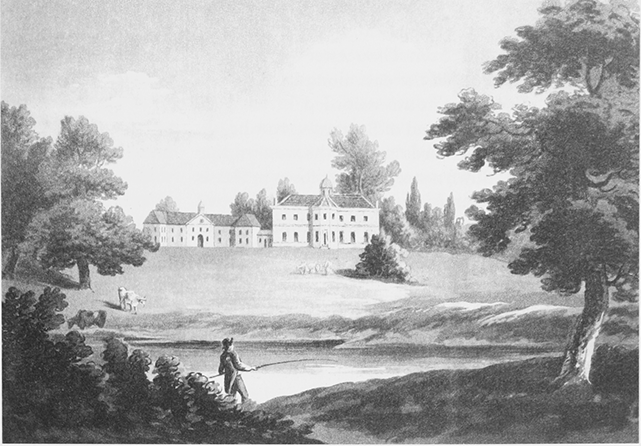
27. Russell's End from the west
BUILDINGS
Medieval houses survive from four of the estates and farms that had been established by the late Middle Ages. Two are stone-built. That at Toney's Farm, sited on a hillside platform, dates from the 14th century and displays very high-quality timberwork. (fn. 135) The manor house, set within a complex of much more recent farm buildings west of the church at Bromesberrow Court, is similar in plan but probably later. (fn. 136) The other two medieval houses are timberframed and probably of the 15th century; Upper Brookend stands on a level site close to the Glynch brook (fn. 137) and Russell's End is at the foot of a steep slope down to the brook. The latter preserves at its core a cruck-framed range (fn. 138) comprising a hall of two bays and a 1½-storeyed chamber end of one bay: the hall retains the north door to its cross passage. Altered floor levels suggest that the chamber end originally had two full storeys before the surrounding ground was made up. The upper part of the present cellar represents the lower part of the range's ground floor; with a higher floor level than at present the solar would have been open to the roof.
There was much building activity in the parish in the 16th and 17th centuries. Major improvements were made at Russell's End, leading the house to be described in 1592 as new. (fn. 139) The east, service end of the medieval range was rebuilt and it is likely that the insertion of an upper floor in the hall, the erection of a massive south chimneystack, and the construction of a larger cellar were also contemporary. The chamber end was extended southwards by the addition of a 2½-storeyed block with a large room on each floor and three-light mullioned windows (now blocked) on the east front. It was heated by a west chimneystack of brick on a stone base, whilst the frame, infilled with brick, has some close studding for display. The new block was adjacent to a buttery and it contained the parlour and upper chambers that in 1617 John Brooke, on assigning the house to his widowed daughter-in-law for her life, retained for his own use. (fn. 140) In the late 17th century the parlour was refitted with panelling and a new chimneypiece.
Improvements were made at the other three medieval houses in the parish, that at Upper Brookend being almost completely rebuilt on a larger scale in the 17th century. (fn. 141) Brown's End, which is mainly 17th-century in date, is very similar in character to Upper Brookend and both houses, in addition to the manor house and Russell's End, had five hearths each in 1672. (fn. 142) One hearth at Brown's End perhaps belonged to a surviving bakehouse. (fn. 143)
In the 17th and 18th centuries several new houses were also raised in Bromesberrow. The timberframed house at Lower Brookend was built in the mid 17th century to a T plan and possesses highquality brick nogging. The slightly raised chamber wing to the south is marked out as superior by close studding on the main, east elevation and two star chimneys on the south. The main range appears to have been rebuilt on a larger scale with two storeys and attic rooms in the late 17th century and a rear outshut was added shortly afterwards. Near Bevan hill Bavenhill Farmhouse, a thatched timber-framed dwelling with an L plan, is of the late 17th century and at Chase End a small timber-framed cottage, initially of one bay, was erected at a similar date. (fn. 144) Grove House, a large brick house of the late 17th or early 18th century, was possibly the first building in the parish to be designed in the neo-classical style. The tall, main block has two storeys over a high basement, taking advantage of its position on a slope, a symmetrical south front, long segment-headed windows, hipped roofs, and prominent flanking chimneystacks. (fn. 145) A range of farm buildings to the south includes stables contemporary with the house.
The major building project of the later 18th century was Bromesberrow Place. A scheme of John Yate (d. 1758) for a small house on top of Coneygree hill proved impractical and instead the timberframed farmhouse at Hook House, the Yates' existing residence, was extensively remodelled as a brick mansion, perhaps completed in 1772. (fn. 146) Dyke House was rebuilt c.1790 in red brick on an L plan and incorporates part of an earlier stone-built house retained as a kitchen with a cellar beneath. A plain single-pile front range of three bays and two storeys with sash windows has a cider cellar under the south end, and a north wing with casements incorporates a staircase and former dairy.
The 19th century was mainly a period of improvements to existing houses, Toney's Farm among them. (fn. 147) Grove House was enlarged and given new dormers and Dyke House gained a new kitchen. Alterations at Russell's End included new windows, tiled roofs, and new north and west entrances. Some walls were rebuilt in brick and the interior was reconfigured. At Bromesberrow Court a polite brick front facing the church was built in the early 19th century and an almost free-standing block towards the farmyard was added later in the century. (fn. 148) Farm buildings were rebuilt or added at Brown's End in 1839, possibly to designs by J.G. Price, (fn. 149) and an early 19th-century brick barn was constructed at Lower Brookend. The farmhouse near Bevan hill gained a lean-to cider house. (fn. 150) At Dyke House, where a barn is dated 1838, many new farm buildings were constructed in the 1880s. Bromesberrow Place was the property most thoroughly transformed. There Osman Ricardo through his architect created a stuccoed neo-Greek country house c.1823. (fn. 151) A contemporary or slightly later south-west lodge, a cottage ornée, was used for a time as a school. (fn. 152)
New buildings in the 19th century were few, the chief one being a rectory house built in brick in 1802 in the neo-classical style on a site above its predecessor. (fn. 153) Also important to the local community was a school of 1871, a small plain building in Malvern stone with polychrome window heads. (fn. 154) Other additions in the 18th and 19th centuries were restricted to a few cottages, notably those surviving on and close to Bromesberrow's three ancient commons. Although ten council houses were erected in the parish during the 1930s and 1940s, (fn. 155) the 20th century saw only limited new development. Despite the erection of new farm buildings at Bromesberrow Court and apple-packing sheds at Dyke House in the second half of the century, by 2007 many farmhouses had lost their agricultural purpose and were occupied as country homes. Several outbuildings had been converted for residential or commercial purposes, those at Russell's End being made dwellings in the 1990s. (fn. 156)
MANOR AND ESTATES
Following the Norman Conquest Bromesberrow became the possession of the de Tony family and from the later 14th century the manor belonged to the Bromwich family. Estates under the manor included a yardland held in 1287 by Flaxley abbey as farmer of Dymock manor. (fn. 157) Land on the boundary with Eastnor (Herefs.) acquired in 1483 by Richard Beauchamp, Lord Beauchamp, was granted by Henry VII to the Talbots of Grafton (Worcs.), later earls of Shrewsbury, and descended with Bronsil castle in Eastnor. (fn. 158)
With the amalgamation of many holdings a pattern of substantial freehold farms emerged in Bromesberrow by the 17th century. Starting in 1663 the Yate family built up an estate that from 1708 included the manor, the principal seat of which was transferred from Bromesberrow Court to Hook House (later Bromesberrow Place). The estate continued to be enlarged until 1929, when two farms were sold off, (fn. 159) and it fragmented further following the death of Dinah Albright in 1990. (fn. 160) The Eastnor estate acquired Lower Brookend and Pepper Mill in 1735 (fn. 161) and sold them in the 1960s. (fn. 162) Dyke House was part of the Haffield estate from 1871 to 1927. (fn. 163)
BROMESBERROW MANOR
An estate of five hides at Bromesberrow held in 1066 by Earl (i.e. King) Harold belonged in 1086 to Ralph de Tony (Tosny). (fn. 164) Ralph, who granted part of the demesne tithes to Conches abbey (Eure), (fn. 165) died c.1102 and his estates passed to his son Ralph (d. c.1126). (fn. 166) The manor was held for a knight's fee of Thomas de Beauchamp (d. 1401), earl of Warwick, (fn. 167) whose overlordship evidently descended from the marriage of Guy de Beauchamp (d. 1315), earl of Warwick, with Alice, daughter of Ralph de Tony and sister of Robert de Tony. (fn. 168) Later the manor was held from Hanley Castle (Worcs.). (fn. 169) Its lords, who had a jurisdiction in Bromesberrow as the chief lords of Malvern Chase, (fn. 170) included the successive husbands of Isabel le Despenser, namely Richard de Beauchamp (d. 1422), earl of Worcester, and from 1423 Earl Thomas's son and heir Richard de Beauchamp. (fn. 171)
In 1200 when held by Roger de Portes the manor was taken temporarily in hand by the Crown. (fn. 172) Later Matthew de Portes was lord of Bromesberrow (fn. 173) and the manor passed to Richard de Portes, the ward of Richard du Boys in the 1280s. Richard de Portes, who came of age by 1291, (fn. 174) was lord of Bromesberrow in 1316 (fn. 175) and had a house there (fn. 176) after William de Whitefield was granted free warren in the demesne in 1320. (fn. 177) William died by 1349 and his widow Constance, who married Stephen de Casynton, retained a life interest in the manor in 1367, when it belonged to John Bromwich (fn. 178) (d. 1388). (fn. 179) John's widow Catherine married in turn Hugh Waterton (d. 1409) (fn. 180) and Roger Leech and on her death in 1420 the manor passed to John's nephew Thomas Bromwich. (fn. 181) Another John Bromwich presented to the rectory in 1447 (fn. 182) and a second Thomas Bromwich held his first manor court in 1467. In 1473 William Botte, vicar of Norton (Herefs.), held the court, presumably as a guardian. In 1476 the manor belonged to John Bromwich (d. 1485) and his wife Maud. Their son and heir John, who held his first court in 1487, (fn. 183) died in 1512. His widow Ann or Agnes (née Payne) (fn. 184) married William Whittington, son of John Whittington of Pauntley, c.1514 and on her death c.1540 the manor reverted to her son John Bromwich of Tarrington (Herefs.). (fn. 185) John (d. 1567) was succeeded in turn by his son John (fn. 186) (d. 1592) and the latter's nephew Edward Bromwich of Frampton on Severn. (fn. 187) On Edward's death in 1624 the manor passed to his son Isaac, a minor. (fn. 188) Isaac, lord in 1641, (fn. 189) died by 1667, leaving the manor to his son Robert, (fn. 190) who settled it on his son Edmund in 1703. Edmund sold it in 1706 to John Hyett of Gloucester and he conveyed it in 1708 to Walter Yate of Hook House. (fn. 191)
From Walter Yate, who in 1736 acquired Aubreys farm through an exchange of lands with the trustees of a Sandhurst charity, (fn. 192) the manor passed at his death in 1744 to John Yate, son of Richard Yate of Arlingham. John died in 1749 and under Walter's will the estate reverted to John Yate, only son of Charles Yate of Arlingham. On John's death in 1758 it passed to Robert Dobyns of Evesbatch (Herefs.), grandson of Walter's sister Catherine, on condition that he adopted the surname Yate. (fn. 193) Robert, known therefore as Robert Dobyns Yate, (fn. 194) was High Sheriff of Gloucestershire in 1765 (fn. 195) and died the following year, leaving the manor to his son Robert Gorges Dobyns Yate. (fn. 196) Robert, under whom the family seat at Hook House was transformed into the mansion known as Bromesberrow Place, (fn. 197) died in 1785. (fn. 198) His son and heir Walter Honywood Yate came of age in 1799 (fn. 199) and sold the manor in 1811 subject to his life interest to Joseph Pitt of Cirencester. In 1818 Pitt sold the estate to the political economist David Ricardo of Gatcombe Park, in Minchinhampton, (fn. 200) who later the same year purchased W.H. Yate's interest and, a year later, agreed to settle some of his debts. (fn. 201)
When David Ricardo died in 1823 (fn. 202) his Bromesberrow estate passed to his eldest son Osman, who owned c.875 a. in the parish in 1838. (fn. 203) Osman (d. 1881) was succeeded by his nephew Frank Ricardo (d. 1897), (fn. 204) who had in 1876 inherited Russell's End farm from his father Mortimer. (fn. 205) Frank's son and heir Frank lived at Bure Homage in Christchurch (Hants) and broke up the estate in 1929, selling the bulk of it with Bromesberrow Place to George Stacey Albright and Bromesberrow Court and its farm to Beatrice Waudby-Griffin. Russell's End was sold to George Chance of Stourbridge (Worcs.). (fn. 206) On Albright's death in 1945 (fn. 207) his estate, extending across c.1,500 a. in Bromesberrow, Redmarley D'Abitot, and Berrow (Worcs.), (fn. 208) passed to his niece Dinah Albright. Following her death in 1990 (fn. 209) some farms were sold to their tenants, (fn. 210) but most of the estate was purchased with Bromesberrow Place by Dr The Hon. Gilbert Greenall. (fn. 211) Beatrice Waudby-Griffin married A.R. Rowden (d. 1947) (fn. 212) and following her death in 1976 Bromesberrow Court was sold to William Sargeant. He died in 1996 and his son Mr Peter Sargeant owned the house and farm in 2007. (fn. 213)
Bromesberrow Court
The medieval manor house, west of the church at Bromesberrow Court, was constructed largely from red sandstone rubble on an L-shaped plan with hall and service end in line and an east chamber wing projecting south. The hall range, into which a floor was inserted in the 17th century, retains a pair of principal rafters, one purlin, and part of a ridgepiece, all smoke-blackened. The east wing has massive beams with broach stops supporting the upper floor and a timber-framed north extension of two storeys that probably dates to the 18th century. In the early 19th century the building was raised and extended in brick. A neo-classical front of three bays and two storeys with sash windows was created to face the church and the hall range was extended northwards, later being converted into cottages with a late 19th-century two-storeyed block on its north side. In the 20th century the internal circulation was improved with the creation of new entrances and the insertion of a staircase at the south end of the house. The extensive farm buildings of 19th- and 20thcentury date include a tallet house with unusual diagonal framing.
Hook House
Hook House, the residence of the lords of the manor from 1708, stood on Bromesberrow's eastern boundary and was rebuilt in the 18th century with the name Bromesberrow Place. (fn. 214) Members of the Hook family are documented from 1369, when Reynold Hook (atte Hoke) was bailiff. (fn. 215) In 1424 William Hook, rector of Redmarley D'Abitot (Worcs., later Glos.) and former rector of Bromesberrow, held a property called Hook's Place. (fn. 216) It passed to his nephew Thomas Hook by 1463 (fn. 217) and was held by Thomas's son Guy in 1487. (fn. 218) Roger Bradford (d. 1552) left Hook House to his eldest son John (d. 1561) (fn. 219) and William Bradford enlarged the estate by the purchase in 1565 of property called Chelnage and Longneys from Francis Miles, a Leicester fishmonger. (fn. 220) William died in 1613 (fn. 221) and Edmund Bradford sold the estate by deeds of 1648 and 1655 to Humphrey Morton of Eastnor. Humphrey sold it in 1663 to Rice Yate of, in turn, Llangandeirne (Carmarthenshire) and Gloucester. (fn. 222) Rice, who acquired more property in Bromesberrow (fn. 223) including woodland, (fn. 224) died in 1690 and was succeeded by his son Walter. (fn. 225)
28. Bromesberrow Place: the south front in 1991
Walter (d. 1744) continued to live at Hook House after purchasing the manor. (fn. 226) A small house begun according to his wishes (fn. 227) by John Yate (d. 1758) on the summit of Coneygree hill was in 1762 the subject of plans with a grandiose Palladian design by Ferdinando Stratford. (fn. 228) The site proved impractical and instead Hook House was greatly enlarged to make Bromesberrow Place. The new brick mansion, finished perhaps in 1772, (fn. 229) retained part of the timber-framed farmhouse in the south-east angle. The west-facing entrance front was of nine bays and two storeys with a central canted bay reminiscent of Stratford's design for the wings of the aborted house rising the full height. Whilst the back of the house looked more old-fashioned with three storeys, bands between them, and slightly-projecting end bays, the south front was similar with an off-centre two-storeyed canted bay and a west wing of one bay. A cupola lit a central staircase and, to the north, an adjacent H-plan stable block in the same idiom incorporated a service range; the staircase and stables are the most complete survivals from that house. (fn. 230)
Shortly after 1823 Osman Ricardo and his architect, probably George Basevi, (fn. 231) created a stuccoed neo-Greek house with a sequence of handsomely decorated rooms (drawing room, entrance hall, and dining room) along the west front. Doric porticoes were placed to the west and south and a camellia house with a cast- and wrought-iron structure was built on the south-east side. (fn. 232) Inside, a second staircase was inserted immediately to the south of the existing one. In the late 19th century a billiard room was added on the north-west side. Alterations in the 20th century included the insertion before 1961 of twin arches opening the staircase compartments. (fn. 233)
OTHER ESTATES
Upper Brookend
An estate based on the house at Upper Brookend sometimes known as Hall Place belonged in 1424 to Joan Pendock and in 1475 to John Beale. John's son and heir John had the freehold in 1487 and John Beale of Bushley (Worcs.) owned it in 1506. In 1527 William Grove sold the estate, described as a manor, to Thomas Stone (fn. 234) (d. 1546), (fn. 235) from whom Upper Brookend descended in the direct line to Roger (d. 1591), Thomas (d. c.1658), William (d. 1683), and Thomas (d. 1693). Thomas was succeeded by his brother Guy (d. 1743), a London cutler, and the descent in the Stone family from father to son resumed, the estate (c.100 a. in the later 18th century) passing to Samuel (d. 1758), Revd Guy (d. 1779), Samuel (d. 1825), Guy (d. 1862), and Samuel (d. 1921). Samuel's sister Elizabeth Stone (d. 1944) left the estate to her niece Marion Edith Fry, wife of Sir Charles Fawcett. (fn. 236) In 1944 Lady Fawcett sold Upper Brookend to A.R. Rowden (d. 1947) and following the death of Rowden's widow Beatrice in 1976 it was sold to Alan McKechnie. He sold it in 1992 to Mr Anthony McClellan. (fn. 237)
Heavy timber framing in the hall range at Upper Brookend appears to date from the 15th century and may represent the hall with a chamber of three bays that William Stone was required to build anew for John Beale in 1475. (fn. 238) In the 17th century the house was almost entirely rebuilt to an H plan by the addition or redevelopment of a north chamber wing with diamond chimneystacks and close studding in the gable and the provision of a plainer south service range. In 1672 it was one of the five largest houses in the parish, taxed at five hearths. (fn. 239) Extensive outbuildings were erected around a farmyard to the west in the 18th or early 19th century; (fn. 240) some were demolished or converted to living accommodation in the 1980s, when the house also was much remodelled, (fn. 241) the upper parts of the timber framing and the interior being recreated. Further alterations and additions were made c.2000 to designs by Craig Hamilton: a new north-west wing of sandstone with entrance hall formed the south side of an entrance court enclosed on the north by a garage and a cloister garden was laid out to the west of the house. (fn. 242)
Brown's End
An estate at Brown's End included a house called Hatches which Christopher Hooke of Pauntley sold in 1559 to John Stone (d. 1578). The latter's son John owned the estate in 1614 (fn. 243) and it passed at his death in 1632 to his son John (d. 1633), whose son John (d. 1695) (fn. 244) held it in 1672. (fn. 245) Another John Stone owned Brown's End in 1707 and left it at his death in 1742 to his sister Mary (fn. 246) (d. 1767), wife of Revd Giles Nanfan, rector of Birtsmorton (Worcs.). (fn. 247) Another Mary, the widow of John Nanfan of Brown's End (d. by 1749), (fn. 248) had the estate in 1775 (fn. 249) and Margaret (née Walford), the widow of John Nanfan, son of Giles and Mary, owned it in 1787. Margaret was succeeded by 1794 by her daughter Margaret Nanfan, who married in turn Thomas Webb of Sherbourne and Revd. James Davenport of Stratford-upon-Avon (both Warws.) and by will proved 1830 left an estate of 170 a. to her son John Webb. (fn. 250) John (d. 1845) left the estate to his nephew Thomas Townsend Webb (fn. 251) (d. 1859), who was succeeded by his son Elias (d. 1930). (fn. 252) Brown's End passed to Elias's son John Elias Nanfan Webb, who sold part of the estate to G.S. Albright in 1938. (fn. 253)
The former farmhouse at Brown's End, which was sold in 1956 to R.F. Clarke, (fn. 254) is a timber-framed H-plan house of 17th-century date with a 2½storeyed central range of four bays and east and west wings of two and three bays. In 1672 it was one of four houses in the parish with five hearths, (fn. 255) one of them perhaps in a surviving detached timberframed bakehouse of 1½ storeys. The house was enlarged in brick in the late 18th century and a porch and rear extension were added in the early 20th. Farm buildings include a shelter shed and barn of the early 19th century. The latter incorporates re-used crucks and bears a stone giving the date 1839 and the name J.G. Price. (fn. 256)
29. Roof timbers of Toney's Farm
Toney's Farm
Toney's Farm, named after a family resident in Bromesberrow by the early 13th century, (fn. 257) was part of an estate that passed from Robert Toney (fl. 1424) (fn. 258) to his son John. John's son and heir Richard, a minor in 1472, was dead by 1473 and the estate passed to John's brother Robert (fn. 259) (fl. 1487). (fn. 260) In 1522 Henry Toney's landholding in Bromesberrow was second in value only to that of the lord of the manor. (fn. 261) Richard Smith and his wife Eleanor, formerly wife of Roland Wrenford, the son and heir of Thomas Wrenford of Castlemorton (Worcs.), owned Toney's farm in 1606 and Eleanor's children Richard Wrenford and Frances, wife of Thomas Tracy, sold it in 1620 to William Coxe (fn. 262) (d. 1666). (fn. 263) In 1667 William's son William conveyed the estate (c.150 a.) to John Wodley (d. 1670 or 1671), who left it to his son William. In 1677 John Coxe of Tarlton bought the farm for his brother Richard, then living in Ireland. Richard sold it the following year to Rice Yate, (fn. 264) the owner of Hook House, with which the farm descended, from 1708 as part of the manor estate, (fn. 265) until it was bought in 1992 by Mr Francis Windsor Clive. (fn. 266)
The house at Toney's Farm preserves at its core a 14th-century hall range built of Malvern stone with a roof of three heavy cruck trusses: that over the centre of the two-bayed hall has arched braces and cusped quatrefoil above the collar. (fn. 267) Perhaps in the early 16th century the hall was floored with massive beams with bar stops and a large chimneystack was inserted in the east bay, apparently the cross passage. In the 17th century the chamber end was reconstructed as a 2½storeyed cross wing, perhaps retaining earlier fabric in its stone-walled ground floor. (fn. 268) The east service end was replaced or remodelled in the 19th century, when some refacing and refenestration of the hall range took place.
ECONOMIC HISTORY
Part of the 'the ryelands' area, (fn. 269) Bromesberrow remained an agricultural parish with a significant woodland economy.
AGRICULTURE
The Middle Ages
In 1086 Bromesberrow manor had 1 plough in demesne and 14 ploughs belonging to 11 villans and 8 bordars. A slave was also recorded. (fn. 270) Four ploughteams were recorded in Bromesberrow in 1220. (fn. 271) Evidence for open-field agriculture is limited, but in the later Middle Ages many tenants possessed parcels in a field called 'Haseldene' in the south-east corner of the parish. (fn. 272) Most arable farming seems to have taken place within closes, some of which bore names such as 'Rudyng' (fn. 273) and 'Heyrudyng' (fn. 274) signifying their origins in clearings from woodland or waste. (fn. 275)
In the late 14th century parcels of the demesne were let to tenants for annual cash rents. Much of that land lay in meadows beside the Glynch brook that were cropped for hay or used as pasture. Every third year certain meadows became common pasture, whilst arable fields on the demesne were commonable after each harvest. Each year the crop from a proportion of the tenanted demesne was reserved for the lord, a custom known as the third sheaf. Grain harvested from the demesne typically comprised barley, oats, and rye, the last commanding the highest price at threshing and at market in Newent. (fn. 276)
In 1487 there were 20 free and 13 customary tenants in the manor. (fn. 277) Many of the former held more than one messuage (one as many as four), implying the consolidation of earlier holdings into larger farms. (fn. 278) Throughout the late 14th and 15th century customary tenants owed cash rents to the lord rather than labour services (fn. 279) and payments in kind included hens (fn. 280) and a goose, which by 1487 was owed by two tenants jointly. (fn. 281) Holdings in the 15th century included yardlands and half-yardlands. In 1467 John Beale, a freeholder, owed 20s. a year for two yardlands (fn. 282) and in 1475 he instructed his tenants at Hall Place (Upper Brookend) to sow a close annually with flax, which they were to pull, dress, and steep for his profit. (fn. 283) The cultivation of vines in medieval Bromesberrow is suggested by the field name 'Vynnyng'. (fn. 284) In 1518 William Whittington was storing fruits and wool, brewing beer, and dressing pig carcasses in a small chapel close to the church. (fn. 285) Cows, sheep, and pigs were among animals kept on farms in the early 16th century (fn. 286) and tenants had rights to common pasture on Howler's heath and in High wood. (fn. 287)
The Early Modern Period
In the early 17th century 6 yeomen, 7 husbandmen, and 5 labourers were resident in Bromesberrow. (fn. 288) No detailed record of holdings exists for the period, but among the larger farms were Hill Place, (fn. 289) Aubreys, (fn. 290) and Toney's, the last of which comprised c.150 a. in 1667. (fn. 291) In 1787 Bromesberrow Court, which had absorbed the land worked from Hill Place, (fn. 292) was the largest farm and the farmers at Toney's and Aubreys were among five other tenants of the Yates' manor estate. Russell's End was a farm on the Grove House estate and Lower Brookend and Hill farm belonged to the Eastnor estate. (fn. 293)
Much of the parish continued to be given over to arable cultivation. In 1667 the manor was said to include 360 a. of arable, 40 a. of meadow, and 60 a. of pasture. (fn. 294) 'Haseldene' remained an open field into the 18th century. (fn. 295) Meadows continued to be valued for both hay and pasture (fn. 296) and many were subdivided into smaller closes by new quickset hedges. (fn. 297) On Howler's heath a sub-circular close known as Priest's Meadow had been created within the common by 1671. (fn. 298) In the west of the parish water meadows are recorded in the early 18th century beside the Glynch brook in an area known as 'the bans' (fn. 299) (later Banks or Bance). (fn. 300)
Mixed agriculture was practised by most farms. There was dairying and pig farming at Russell's End, its owner having 40 cheeses, 3 gallons of butter, and bacon flitches in 1659, (fn. 301) and in 1671 the rectory buildings included two barns and a sheepcot. (fn. 302) About 1703 it was noted that rye from the parish 'sometimes sold dearer than wheat' and was transported for up to 60 miles around. (fn. 303) In 1801, of the 477 a. of arable recorded in the parish, over half produced wheat and barley, whilst other notable crops were turnips (70 a.), rye (54 a.), and peas (29 a.). (fn. 304)
Orchards are recorded from the late 16th century. (fn. 305) The local practice of planting fruit trees on arable land is attested at Aubreys in 1662 (fn. 306) and the rectory house as well as many of the farmsteads had a cider mill in the later 17th century. (fn. 307) Field and yard names indicate that hops were, or had been, grown in several places (fn. 308) and a moat at Aubreys Farm (fn. 309) enclosed a piece of land known in 1662 as 'the vineyard'. (fn. 310) The brewing of beer is suggested by the presence of a malt mill at Upper Brookend in 1592. (fn. 311)
The Nineteenth and Twentieth Centuries
In 1807 the manor estate included farms at Bromesberrow Court (360 a.), Bromesberrow Place (146 a.), Toney's (190 a.), and Aubreys (124 a.). Other holdings over 50 a. were Brown's End (166 a.), Upper Brookend (144 a.), Russell's End (136 a. including Lodwicks farm, part of the manor estate), Grove House (94 a.), Lower Brookend (81 a.), and Dyke House (60 a.). (fn. 312) Ten occupiers employed 67 agricultural labourers in 1831. (fn. 313) In 1851 both Bromesberrow Court and Brown's End farms were managed by bailiffs and Richard Brooke at Grove House provided work for 20 men, women, and boys. (fn. 314) Throughout the 19th and early 20th century the major farms remained much the same size (fn. 315) and the number of farmers recorded in Bromesberrow fluctuated between seven and nine. (fn. 316) In 1926 five of the 20 holdings returned for the parish exceeded 100 a. (fn. 317) In 1956 the equivalent number was seven (out of 18 holdings) and 47 workers had regular employment in agriculture. (fn. 318) In 1986 only 17 individuals worked on eight farms, two of which had over 100 ha (c.247 a.), one between 20 and 30 ha (c.49 and 74 a.), one between 10 and 20 ha (c.25 and 49 a.), and four less than 10 ha (c.25 a.). (fn. 319) In 2007, whilst Aubreys and Hill farms remained tenant holdings on the Bromesberrow Place and Eastnor estates respectively, (fn. 320) much of Bromesberrow's farmland was worked from farmsteads outside the parish. (fn. 321)
In 1838 the parish contained 1,000 a. of arable, 381 a. of meadow and pasture, and 100 a. of waste. There was no trace of open fields, the piecemeal inclosure of 'Haseldene' presumably having been completed much earlier. (fn. 322) Although rye was still grown, Bromesberrow's reputation for the crop had faded (fn. 323) and only 8 a. was returned in 1866. (fn. 324) Most farms were mixed in the early 19th century and one with meadows beside the Glynch brook kept oxen for ploughing and raised Herefordshire cattle and pigs in 1810. (fn. 325) The churchwardens' accounts for the period 1816–38 contain cures for cracked cows' udders and inflammation in sheep (fn. 326) and Brown's End farm, which gained a new barn with a paved stone threshing floor in 1839, (fn. 327) employed a dairymaid in 1851. (fn. 328)
The early 19th century saw a number of smallholdings established on Bromesberrow's commons. (fn. 329) In 1848 a property on Chase End hill included stables, pigsties, and a cow house in addition to two orchards and a cider mill. (fn. 330) Several other dwellings possessed cider mills (fn. 331) and Bromesberrow was known for its perry made from Oldfield pears. (fn. 332) Orchards of apples, pears, and cherries were common throughout the parish and hop gardens were mainly at Chase End. (fn. 333) In 1827 there was a hop kiln at a cottage known as The Box. (fn. 334)
In 1838 the main areas of common land were Chase End hill (38 a.), Howler's heath (30 a.), and Bromesberrow heath (10 a.). (fn. 335) The last was inclosed under an award dated 1864, in which less than an acre was given to Osman Ricardo for his manorial rights and the rest was sold to Richard Brooke of Grove House. (fn. 336) In 1866 the 856 a. of rotated crops returned for the parish included 250 a. of wheat, 219 a. of grass and clover, 166 a. of turnips and swedes, 121 a. of barley, and 51 a. of peas. Some 608 a. was under permanent grass and animals kept on Bromesberrow farms included 1,028 sheep, 165 cattle (including 40 milch cows), and 90 pigs. (fn. 337)
During the late 19th and early 20th century arable land was converted to meadow or pasture. In 1896 Bromesberrow returned 784 a. of permanent grass and 694 a. of rotated crops, the latter including 331 a. of cereals, 159 a. of grass and clover, and 152 a. of roots. In 1926 the area of permanent grass was 919 a. and the reported arable included 223 a. of cereals, 147 a. of grasses and clover, and 90 a. of roots. Dairying continued to be important, 74 milch cows being returned in 1926 when the numbers of beef cattle, sheep, and pigs were 318, 913, and 290 respectively. In 1896 there were 58 a. of orchards and in 1926 64 a. of orchards and soft fruit were returned. (fn. 338) There was a fruit farm at Hatch farm (Brownsend farm) in the early 1930s. (fn. 339) In the late 19th century children from the parish found casual employment picking wild daffodils in the spring and blackberries in the autumn for sale locally. (fn. 340)
By 1956, although the area of permanent grass returned for the parish had shrunk to 492 a., the number of cattle had grown to 484, including 161 milch cows. There were also 658 sheep, 327 pigs, and 3,736 poultry birds. (fn. 341) Plans for a new dairy on the Eastnor estate at Lower Brookend were approved in 1959. (fn. 342) Of the 1,037 a. of arable land returned in 1956, 431 a. were under grass and clover, 397 a. cereals, and 138 a. roots. The area of orchards and soft fruit returned was 90 a. (fn. 343) Dairying remained important and in 1986, when 171 milch cows were returned, at least 56 ha (138 a.) of horticultural crops were produced and one farm specialized in market gardening. Most of the 30 ha (74 a.) of apple and pear orchards returned in 1986 (fn. 344) were at Dyke House, where a fruit farm established after the Second World War remained in business until the late 1990s. (fn. 345) In 2007 new farming ventures in Bromesberrow included alpaca rearing on Howler's heath and a small vineyard at Hatch farm. (fn. 346) A company specializing in sheep breeding was the tenant of Aubreys farm. (fn. 347)
WOODLAND MANAGEMENT
In the 14th century High wood, high up on the north side of Bromesberrow, was a common wood (fn. 348) and the lord of the manor received customary payments of hens ('woodhens') from tenants at Christmas for the right to collect wood. (fn. 349) In 1370 part of the lord's income derived from the sale of an old ash tree. (fn. 350) In the 15th century the lord's wood was on Warlowesdowne (Chase End hill) and was managed by a woodward (often the manorial bailiff), who regularly seized timber felled without permission. Those fined for trespass or theft (fn. 351) included in 1473 William Dene, rector of Redmarley D'Abitot (Worcs.), for taking pheasants and partridges. (fn. 352) In 1546, having inclosed part of High wood, John Bromwich was ordered before commissioners of the Court of the Marches to respect his tenants' right to gather wood for fuel and fencing there. (fn. 353)
In the 1660s part of Bromesberrow's woodland was managed as a source of charcoal for Thomas Foley's iron furnace in Oxenhall. (fn. 354) By 1776 an area of woodland in the north-east of the parish was known as Cole (later Coal) hill (fn. 355) and remains of charcoalburning hearths have been noted in Toney's coppice and Hayes' coppice. (fn. 356) The former, belonging to Toney's farm, was cut after 12 years' growth in the late 17th century. (fn. 357) The latter was one of five coppices on the manor estate, which in 1667 included 50 a. of woodland. (fn. 358) In the mid 18th century colliers (i.e. charcoal burners) were active on the Upper Brookend estate (fn. 359) and later in the century, when most coppiced wood from Bromesberrow was used to make laths, hurdles, and hoops, some was sold as cordwood to iron furnaces at Powick (Worcs.), Lydney, and Flaxley. (fn. 360) In 1789 W.H. Yate derived £100 from the sale of coppiced wood, as well as £7 from timber and £1 6s. 8d. from bark. (fn. 361)
In the early 19th century the manor estate included 87 a. of oak coppices, of which the largest was High wood (29 a.). (fn. 362) In 1838, when those woods were in hand, most of the other major landholdings included at least one coppice. A keeper's cottage is recorded at Woodend (fn. 363) and gamekeepers were resident in Bromesberrow throughout much of the 19th century, (fn. 364) when, by the 1870s, local boys acted as beaters during the shooting season. (fn. 365) During the late 19th and early 20th century timber, mainly elm and oak, and coppiced wood from Bromesberrow were periodically sold at auction. (fn. 366) Sporting rights on the Bromesberrow Place, Lower Brookend, and Dyke House estates were enjoyed by their owners in 1910 (fn. 367) and the Bromesberrow Place estate employed a gamekeeper in the early 21st century. (fn. 368) In 2007 there was a nursery of woodland trees at Russell's End. (fn. 369)
MILLS AND FISHPONDS
The Millward family, established in Bromesberrow by 1327, (fn. 370) held parcels of demesne land called 'mill field' and 'mill croft' in the late 14th century (fn. 371) and Lower Brookend in 1424. (fn. 372) In 1370 the lord of the manor profited from the sale of an old millstone (fn. 373) and in 1394 William Walker held a fulling mill that he had constructed with timber from the manorial demesne. (fn. 374)
The manorial water mill, apparently that recorded in 1472, (fn. 375) was held in 1487 by Robert Bradford. (fn. 376) Pepper Mill on the Glynch brook, (fn. 377) probably the mill which John Jones and his wife Anne owned in 1610, (fn. 378) belonged to the Stock family and operated as a corn mill in 1671. (fn. 379) Built partly of red sandstone, it became part of the Eastnor estate in 1735 (fn. 380) and was remodelled. Successive millers lived there in the 19th century, (fn. 381) of whom James Jauncey employed two men in 1851. (fn. 382) The mill ceased to operate c.1900 (fn. 383) and the Eastnor estate sold its buildings in 1963. (fn. 384)
In 1288 there was a fishpond close to the boundary between Bromesberrow and Eastnor (Herefs.) (fn. 385) and in the late 14th century John Clinton leased a pond from the lord of Bromesberrow and stocked it with 2,000 fish. Situated in 'the chase', (fn. 386) the lord's pond was called 'Chermersh' in 1472. (fn. 387) Its location is likely to have been that of 'Chevernissh pole', described as a boundary mark of Malvern Chase in the 14th century and known as 'Charmill pool' in 1584, by which time it had been drained and was used as meadow. (fn. 388) A cottage and lands called 'Charmers' are recorded in the 17th century at Woodend (fn. 389) and a field beside a tributary of the Glynch brook there bore the name 'pool meadow' in the 19th century. (fn. 390)
INDUSTRY AND TRADE
The field name 'lime pits', documented in the 14th and 15th centuries, (fn. 391) presumably records the digging of lime high up on the boundary with Eastnor close to Hill Farm. (fn. 392) In the 19th century sandstone from Howler's heath and Chase End hill was used on local roads (fn. 393) and at the church. (fn. 394) Some of the numerous masons living in Bromesberrow at that time were presumably involved in quarrying (fn. 395) but in 1883 only one of the quarry scoops visible in the north of the parish remained in use. (fn. 396) A small quarry at Russell's End in 1883 had been abandoned by 1903. (fn. 397)
The crafts or trades of butcher, baker, carpenter, gardener, and tailor are represented in surnames in medieval Bromesberrow (fn. 398) and a skinner was resident in 1436. (fn. 399) The place name 'Smytheshey', documented in 1424 and 1487, suggests the presence of a smith. (fn. 400) A butcher and a glover are recorded in 1596 (fn. 401) and eight tradesmen were listed in 1608: three weavers, a tailor, a carpenter, a glover, a cooper, and a shoemaker. (fn. 402) A wool-winder and a broadweaver were also resident in the early 17th century (fn. 403) and members of two families worked as tailors and weavers at that time. (fn. 404) Two shoemakers are recorded in the 18th century. (fn. 405) A smithy standing on church land in 1683 (fn. 406) continued to function in 1769. (fn. 407)
Eleven carpenters are recorded between 1763 and 1848 and a sawyer lived on Howler's heath in 1808. (fn. 408) Other parishioners engaged in woodland crafts in the early 19th century included a cooper, who also worked as a grafter, (fn. 409) and two hurdle-makers, one of whom was based in Toney's coppice. (fn. 410) Bricks were being made in 1802, (fn. 411) perhaps at the old brickyard recorded in 1812, (fn. 412) and a resident of Chase End in 1819 was a bricklayer. (fn. 413) A blacksmith's shop was established on the south side of Bevan hill by 1803. (fn. 414)
Several bakers and butchers are recorded in Bromesberrow in the 19th century (fn. 415) and two shopkeepers, a grocer, a tailor, and a shoemaker were in business there in 1863. The grocer also operated a carrying service to Gloucester three times a week from Letter House on the Ledbury road, (fn. 416) but in 1870 the only carrier serving the parish was based in Pendock (Worcs.). (fn. 417) In 1935 a daily bus service between Gloucester and Ledbury ran through Bromesberrow. (fn. 418)
In the 1930s a cycle repairer worked at Bromesberrow Heath. The smithy below Bevan hill (fn. 419) later became the site of an engineering firm (fn. 420) that in the early 21st century was in business in Preston. (fn. 421) In the late 20th century the former rectory house was a nursing home (fn. 422) and in 2000 the parish had 17 businesses engaged in agriculture, retail, services, and construction. Only two of them employed more than four people. (fn. 423) In 2007 Grove House was run as a guesthouse (fn. 424) and converted farm buildings at Dyke House and Toney's Farm were used for holiday accommodation. (fn. 425) A company manufacturing bird tables and nesting boxes was based in the former smithy at Bevan hill. (fn. 426) Bromesberrow's post office, established by 1924 and open in 2007, stood just outside the ancient parish in Redmarley D'Abitot. (fn. 427)
LOCAL GOVERNMENT
MANORIAL GOVERNMENT
A manor court was held from at least 1325. (fn. 428) In the later 14th century it met once or twice a year, (fn. 429) but in 1389, despite the arrival of the lord's steward for that purpose, none was held. (fn. 430) In the 15th century the court punished trespassers and poachers on the demesne. A woodward, often the bailiff, made regular presentments for illicit felling of timber in the lord's wood and fines were levied on those who obstructed highways or failed to maintain watercourses. The bailiff regularly impounded stray cattle; on at least two occasions their owners retrieved them by force. (fn. 431) In 1476, following the leading tenants' agreement not to take up office or settle their differences in any higher jurisdiction without the lord's permission, the court fined Robert Cocks for his appointment as constable of Hanley (Worcs.) and a number of people for pursuing justice in the hundred court. (fn. 432)
The manor court lapsed after 1605. (fn. 433) In 1773 R.G.D. Yate attempted to revive it by convening on 11 May a court described as both a court leet with view of frankpledge and a court baron. Its main purpose was to prosecute the petty constables for their failure to maintain the village stocks and whipping post and to erect a pound. (fn. 434) Very few tenants attended and the court never met again. (fn. 435)
PAROCHIAL GOVERNMENT
Bromesberrow's two churchwardens are mentioned in 1385 as custodes ecclesie. (fn. 436) In the later 17th century, when one was chosen in rotation from the major householders, Rice Yate and Robert Bromwich appointed deputies to serve in their stead and by the mid 18th century the appointment of substitutes was common. (fn. 437) In some years in the 19th and early 20th century there was only one churchwarden. (fn. 438) In 1777 the vestry resolved to hold a parish meeting on the first Sunday of every month and in 1792 it agreed to pay the parish clerk an annual salary. (fn. 439) The parish meeting was given the powers of a parish council in 1970. (fn. 440)
The office of constable is recorded in Bromesberrow from the 1630s (fn. 441) and the holder in 1664 failed to return any presentments to the quarter sessions. (fn. 442) In 1802 the lack of a petty constable for Bromesberrow obliged the high constable of Botloe to issue a warrant against an unruly apprentice. (fn. 443)
In the 18th century poor relief was administered by one or two overseers of the poor, serving like the churchwardens in a rotation of the main householders. (fn. 444) The income for relief came in part from the rent of a parcel of land (4 a.) known in 1747 as 'the poors' land'. (fn. 445) That parcel formed part of the church lands charity, originally given for the repair of the church and used by the churchwardens by the 1630s also to fund apprenticeships of children to local farmers and occasional payments to the tramping poor. (fn. 446) In 1785 the overseers paid each household with an apprentice 10s. 6d. (fn. 447) One farmer bypassed his obligation to take on an apprentice in 1796 by paying a fine of 7 gns. (fn. 448) Expenditure by the overseers included repairs to stocks and a whipping post in the year 1796–7. (fn. 449)
In 1751 the vestry decided to build a poorhouse on church land by Woodend Street (fn. 450) and in 1781 it entered an agreement for placing the parish's paupers for a year in the Dymock workhouse. In 1784, during an outbreak of smallpox in the poorhouse, the parish paid the funeral expenses of those who died and later the cost of inoculating 12 inhabitants against the disease. (fn. 451) By 1826 the poorhouse was run as a workhouse under a governor (fn. 452) and in 1829 many of its inmates were set to work on local farms, the men earning 1s. 4d. daily and the women 8d. (fn. 453) In 1835, when Bromesberrow joined the Newent poor-law union, (fn. 454) the poorhouse closed and its 12 occupants were admitted to Newent workhouse. (fn. 455) The house at Woodend Street was let as two dwellings and was rebuilt in 1848 following a fire. (fn. 456) It was sold by the parish in 1964. (fn. 457)
Annual expenditure on poor relief, which had rarely exceeded £15 in the 1730s, rose to £79 in 1783, (fn. 458) following an increase in weekly pay to offset the high price of bread that year. (fn. 459) In 1795 the farmers were advised to allow the poor to glean their fields following the corn harvest. (fn. 460) In 1803, when the annual cost stood at £138, 6 people received permanent and 15 occasional help. Some 35 nonparishioners were also relieved that year, an unusually high number that is perhaps explained by the rapid growth of squatter settlement on the fringes of the parish. (fn. 461) By 1815 annual expenditure had grown to £226, with 23 people receiving permanent and 29 occasional help, (fn. 462) and in 1826 it reached a peak of £429, before dropping back in the following decade to a little over £300. (fn. 463)
The accounts of the parish's surveyor of the highways survive for the period 1768–1818. (fn. 464) Before 1800 his annual expenditure on road and bridge repairs rarely exceeded £10, but in 1805 it grew to £24 and in 1814 it stood at £70. The rise in expenditure, funded by increased highway rates, resulted from much building work: in the year 1815–16 alone 310 tons of stone was purchased from quarries on Chase End hill and Howler's heath. (fn. 465) In 1834 magistrates ordered the parish to devote a third of the highway rates towards the maintenance of turnpike roads in its area (fn. 466) and from 1854 Bromesberrow was expected to pay for all of its turnpike repairs. The vestry first elected a waywarden to the newly-formed Newent Highway Board in 1863 (fn. 467) and the parish's inclusion within the Newent highway district was confirmed in 1867. (fn. 468)
SOCIAL HISTORY
SOCIAL STRUCTURE
In 1327 William de Whitefield, lord of the manor, was assessed for tax in Bromesberrow at 4s. 6d. Of the other residents, Walter Aubrey and Richard Grove were taxed at 5s. 6d. and 5s. respectively, whilst two were taxed at just over 3s., five at just over 2s., and eight at 1s. 8d. or less. (fn. 469) John Bromwich, lord of the manor by 1367, was MP for Gloucestershire in 1365 and was appointed justiciar of Ireland in 1379. (fn. 470) In 1388 and 1390 those harvesting the lord's grain in Bromesberrow were rewarded with bread and ale. (fn. 471)
By the late 15th century customary tenants on the manor owed cash rents rather than labour services. The majority of the population were freeholders, many owning substantial farms. (fn. 472) John Beale held a court for his tenants at Upper Brookend twice yearly in 1475 and the owner held it once every seventh year by 1506 and required his tenants to provide board and lodging for himself and his steward on such occasions. The description in 1527 of Upper Brookend (then called Hall Place) as a manor perhaps reflects the tradition of courts being held there. (fn. 473) The Bromesberrow manor house, known as Bromesberrow Court in 1487, (fn. 474) was occupied by William and Ann Whittington from c.1514 to c.1540; their household included servants, one of whom William later married. (fn. 475) In 1522 William with goods worth £20 was the wealthiest inhabitant of Bromesberrow. Of thirty other inhabitants, excluding the rector, four had goods valued between £6 and £10, three at £4, four at £2, and three at £1; for the rest no valuation was made. (fn. 476)
Among later lords of Bromesberrow, John Bromwich (d. 1592) resided at Bromesberrow Court. (fn. 477) Never marrying, he fathered several children, the eldest of whom, Robert Bromwich alias Dyer, (fn. 478) inherited a farm in Bromesberrow that John purchased in 1580. (fn. 479) In 1608 James Bromwich, uncle of Edward Bromwich, (fn. 480) occupied the manor house with a household including at least one servant. The other men listed in Bromesberrow that year comprised 6 yeomen, 7 husbandmen, 5 labourers, and 8 craftsmen or tradesmen. (fn. 481) Between 1640 and 1700 eight Bromesberrow boys were apprenticed to Gloucester masters. (fn. 482) Of Bromesberrow's 29 householders in 1672, 10 were excused payment of hearth tax, 9 were assessed at one hearth each, 2 had two hearths, and 3 had three hearths. Robert Bromwich, lord of the manor, was among 4 residents to have five hearths each and John Stock had ten hearths. (fn. 483)
Robert Bromwich and Rice Yate were the only Bromesberrow residents summoned to attend the heralds' visitation of 1682 and 1683. (fn. 484) Yate (d. 1690), a former Royalist cavalry officer, (fn. 485) had purchased Hook House in 1663 (fn. 486) and the Bromwich family's Frampton on Severn estate in 1670. (fn. 487) After acquiring the manor in 1708 Walter Yate (d. 1744) continued to use Hook House as his principal residence. (fn. 488) His heir John Yate (d. 1749) worked in London as a barrister. (fn. 489) The Stone family, owners of Upper Brookend, took up residence in Ireland in the mid 18th century and let their estate to tenants. (fn. 490) In the late 18th and early 19th century most farms, including Bromesberrow Court, were occupied by tenants, (fn. 491) some of whom are commemorated in elaborate chest tombs in the churchyard. (fn. 492)
R.G.D. Yate (d. 1785), lord of Bromesberrow from 1766, oversaw the completion of Bromesberrow Place c.1772, paid for improvements to the church's fabric, and installed his brother H.G.D. Yate (d. 1812) as rector. (fn. 493) The latter frequently embellished parish records with his poetry and quotations from classical sources. (fn. 494) Bromesberrow Place, which in the later 1780s was let to John Somers Cocks (later Earl Somers) during the minority of W.H. Yate, (fn. 495) was celebrated in the early 19th century for Yate's museum of curiosities incorporating many items originally collected by the antiquary Richard Greene (d. 1793). (fn. 496) In 1812 a Hygeian temple was among buildings in its grounds. (fn. 497)
In the late 18th and early 19th century a number of squatter cottages were built on Bromesberrow's commons, (fn. 498) one of which at Chase End was erected with the lord's permission by a Yate family servant. (fn. 499) In 1851 twelve households included servants and in 1861 those employing five or more were Bromesberrow Place (10), the rectory (7), Grove House (5), and Brown's End (5). Fairfields was occupied in 1851 by Thomas Hill, rector of Staunton, and in 1861 by Henry Moore, a banker in Ledbury (Herefs.). (fn. 500) Osman Ricardo (d. 1881), who inherited the manor in 1823, was resident and active as a landlord, buying up several cottages in the parish. (fn. 501) He and his wife Harriet established new schools. (fn. 502)
In 1929 Bromesberrow Place was sold to G.S. Albright (d. 1945), its tenant from 1904. (fn. 503) He was a member of a Birmingham Quaker family and a director of Albright & Wilson Ltd, manufacturers of phosphorus for the match industry. (fn. 504) Other prominent landowners in Bromesberrow in the early 20th century included several military officers, (fn. 505) in addition to J.E.N. Webb, owner of Brown's End, who worked as a railway engineer in India. (fn. 506) Albright's niece Dinah Albright developed one of the largest private orchid collections in the country at Bromesberrow Place (fn. 507) and in 1978 established the Albright Trust, a charity which in 2007 funded local organisations and provided accommodation for a clergyman in the former rectory house in Albright Lane. (fn. 508)
CHARITIES FOR THE POOR
In 1683 Robert Bromwich held £9 10s. for an annual distribution to the poor on the feast of St Thomas (21 December). (fn. 509) The charity's principal, later recorded as £10 donated by the Leadington family, (fn. 510) was enlarged by £30 left by Walter Yate by will proved 1745. (fn. 511) A gift of £30 by Catherine Yate (d. 1711), by will proved 1751, for a distribution on the anniversary of her burial (fn. 512) was included in the St Thomas's day charity by the 1780s. (fn. 513) Revd H.G.D. Yate, who paid for doles of bread during the harsh winter and spring of 1795, (fn. 514) left by will proved 1813 the income from £70 stock to be distributed to the second poor on St Thomas's day. The gift was subject to life interests (fn. 515) and had not become effective by 1829. By that date £10 from the St Thomas's day charities had been added to £100 (£90 after legacy duty) (fn. 516) which under the will, proved 1818, of H.G.D. Yate's sister Anne Foote was to be used by the rector to provide for blankets and clothing for sick and elderly churchgoers on that day. (fn. 517)
The St Thomas's day charities, which are recorded on a charity board erected in the church c.1845, (fn. 518) yielded an income of c.£7 in 1870 (fn. 519) and continued to be distributed on the appointed day in the late 19th and early 20th century, mostly in the church after matins (fn. 520) but occasionally in the school. (fn. 521) Anne Foote's charity was given as clothing in 1932 (fn. 522) and the four charities were managed together by 1963. (fn. 523) Revd F.F. Rigby, rector 1962–73, (fn. 524) distributed the charities in cash, 14 parishioners receiving 10s. each in one year, (fn. 525) but by 2000 all the charities had ceased to exist. (fn. 526)
The educational charity of Thomas Eckley, given by will dated 1716, provided for binding poor children of the parish apprentices. (fn. 527)
EDUCATION
In 1678 the rector, Richard Eaton, was licensed as the headmaster of a school in Bromesberrow. (fn. 528) William Stone, rector of Eastnor (Herefs.), by will proved 1702 left £5 to instruct one Bromesberrow child in the English language and the catechism. (fn. 529) Thomas Eckley of Grove House by will dated 1716 left £50 towards keeping poor children in school and binding them apprentices, the principal being vested initially in Joseph Weale, heir to Grove House. (fn. 530) Both charities are recorded in 1791 (fn. 531) but had lapsed by 1818. In that year a mixed day school supported by voluntary contributions taught c.30 children. (fn. 532) The same school had 29 pupils in 1826, when there was also a Sunday school, (fn. 533) and 19 in 1833. (fn. 534)
In 1826 a school educating girls at parental expense was established in the lodge at Bromesberrow Place. It taught c.30 girls in 1833 (fn. 535) and, with the support of Harriet Ricardo, continued in 1868. (fn. 536) Sarah Hodges was schoolmistress there for 40 years. (fn. 537) A Sunday school begun in 1828 was privately funded and taught 20–30 boys in 1833. (fn. 538) In 1836 Osman Ricardo established a day school for boys and from 1838 it occupied a new stone building at Woodend next to the teacher's cottage. In 1852, when as Bromesberrow Church school it had an average attendance of 38, pupils paid pence and Ricardo met any shortfall in income. (fn. 539) It had closed by 1868, when boys from Bromesberrow attended schools in Pauntley and Berrow (Worcs.) (fn. 540)
An infant school is recorded in the late 1850s, (fn. 541) and in 1861 an assistant schoolmaster lived at Bromesberrow Heath, (fn. 542) where there was a school in 1863. (fn. 543) In 1868 some younger children attended the nearby Haffield school, in Dymock. (fn. 544)
A new school erected on glebe land close to the rectory house opened in 1872 and as Bromesberrow National school taught 34 boys, girls, and infants in its first year. (fn. 545) The building, constructed in Malvern stone to designs by Middleton & Goodman, (fn. 546) comprised a teacher's house and a schoolroom used also for a Sunday school (fn. 547) and was largely paid for by subscription, of which £120 came from the sale of land to Richard Brooke at the inclosure of Bromesberrow heath. (fn. 548) The school was funded by pence and by subscriptions from Osman and Harriet Ricardo, Henry Moore, and Revd R.P. Hill, all of whom were regular visitors. (fn. 549) In 1904 the average attendance was 52. (fn. 550)
Throughout much of the late 19th and early 20th century attendance was often low and the turnover of staff high. (fn. 551) Following a series of inspections highlighting cramped accommodation, (fn. 552) a new classroom for infants was built in 1900. (fn. 553) The school changed its name to Bromesberrow C. of E. school in 1906. The average attendance dropped to 27 in 1918 (fn. 554) but recovered to 45 in 1922 and 67 a decade later. (fn. 555) The older boys were transferred to a school in Ledbury (Herefs.) in 1942. (fn. 556) In 1967 and 1968 the school was remodelled and enlarged, partly at the expense of Dinah Albright, (fn. 557) and from 1969 it was known as Bromesberrow St Mary's C. of E. Primary school. (fn. 558) It retained voluntary aided status in 2005, when 55 children were on the roll. (fn. 559) A nursery was established in 2001 (fn. 560) and a school hall was completed in 2004. (fn. 561)
SOCIAL LIFE
A church house, long demolished in 1725, stood in a corner of the churchyard. (fn. 562) The parish vestry usually convened in the church and in the 1860s Letter House hosted meetings to decide the inclosure of Bromesberrow heath. (fn. 563) Bromesberrow appears never to have had a licensed public house, but in the late 19th century the Bell inn at Bromesberrow Heath was the meeting place of a friendly society with a membership drawn from Bromesberrow and Dymock. (fn. 564)
Soon after G.S. Albright's arrival at Bromesberrow Place in 1904 a reading room and a parish library were established, the room being accommodated in the rectory coach house. (fn. 565) In 1909 a temperance society drew members from the parish (fn. 566) and c.30 individuals subscribed to coal and clothing clubs run by the rector. (fn. 567) There was a village cricket club in 1912. (fn. 568) In the conflict of the First World War 12 parishioners lost their lives and in 1921 a stone cross (fn. 569) was unveiled on the green in front of the school as their memorial. (fn. 570)
A village club, opened in 1922 and enlarged in 1928, (fn. 571) had G.S. Albright as its president. (fn. 572) In 1939 the building burned down and in 1950 a replacement village hall was erected east of Coneygree hill on land owned by Dinah Albright. A sports field was also created there. (fn. 573) The hall was rebuilt using entirely local voluntary labour in 1992 (fn. 574) and, having been extended in 2002, (fn. 575) was used by local organisations, including a bowls club and a gardening and social club, in 2007. (fn. 576)
RELIGIOUS HISTORY
EARLY HISTORY AND STATUS OF THE PARISH CHURCH
In the late 11th century Ralph de Tony granted the greater part of his demesne tithes to the abbey founded at Conches (Eure) by his father Roger. (fn. 577) A parson is recorded in Bromesberrow in the early 13th century (fn. 578) and in the 1260s a rector disputed Conches abbey's title to some of the tithes. (fn. 579) The living has remained a rectory and from 1935 it included Bromesberrow Heath, Lintridge, and part of Ryton in Dymock, to the south. (fn. 580) In 1981 the benefice merged with four others to form the united benefice of Redmarley D'Abitot and Bromesberrow with Pauntley, Upleadon and Oxenhall. (fn. 581) From 2000 the united benefice also included Dymock with Donnington and Kempley and Preston. (fn. 582)
PATRONAGE AND ENDOWMENT
The advowson of the church descended with the manor until the early 19th century. In the 1280s Richard du Boys made three presentations during the minority of Richard de Portes. (fn. 583) The bishop presented to the living in 1488 (fn. 584) and upheld the right of William Whittington and his wife to the patronage against the claim of John Bromwich in 1521. (fn. 585) The Crown was patron by lapse in 1596 and patrons for a turn were Richard Stone, rector of Redmarley D'Abitot, in 1601, Sir Richard Tracy in 1620, and Thomas Webb and John Abbot in 1709. (fn. 586) In 1809 W.H. Yate sold the advowson to William Lygon, Lord (later 1st Earl) Beauchamp. Of the earl's successors (fn. 587) the 6th earl sold it in 1867 to Mortimer Ricardo (fn. 588) (d. 1876), from whom it passed to his son Frank. On Frank's succession to the Bromesberrow estate in 1881 the advowson was reunited with the manor (fn. 589) and in 1933 it was transferred to the bishop. (fn. 590)
The rectory was valued at £10 in 1291. (fn. 591) Conches abbey's interest in Bromesberrow presumably passed to the priory of Great Malvern (Worcs.), which in 1271 the bishop confirmed was entitled to half the demesne tithes. (fn. 592) The rector later received all the tithes and paid the priory a pension of 4s. for a share of the corn tithes. The living was worth £7 15s. in 1535. (fn. 593) In 1671 the rector took all the tithes in kind (fn. 594) but by 1730 a standard modus had been established for payment of the small tithes. (fn. 595) The tithes were commuted for a corn rent charge of £362 in 1838. (fn. 596) In 1671 the glebe included strips in the open fields (fn. 597) and in 1725 Walter Yate gave the rector ¼ a. in exchange for a corner of the churchyard. (fn. 598) In 1838 the glebe comprised 55 a. in closes mostly near the rectory house (fn. 599) and in 1939 it covered c.45 a. (fn. 600) The living was worth £65 in 1650, (fn. 601) £100 in 1750, (fn. 602) and £356 in 1856. (fn. 603)
The rectory house contained five bays and had six outbuildings in 1671. (fn. 604) In 1802 a new brick house (The Old Rectory) was built on a more elevated site close by at the expense of Revd H.G.D. Yate and his nephew W.H. Yate to designs by James Millard of Gloucester. (fn. 605) Standing c.500 m north-east of the church, it has a neo-classical front of three bays and 2½ storeys and a plain two-storeyed rear. (fn. 606) Minor alterations were made chiefly to the service rooms in 1877 and 1878 (fn. 607) and the house was sold in 1955. A new rectory house (The Rectory) built in 1958 in Albright Lane was sold in 1979 to Dinah Albright and was owned in 2007 by the Albright Trust. (fn. 608)
RELIGIOUS LIFE
The Middle Ages
The medieval parish church comprised chancel and nave with a low belfry over the west end. (fn. 609) The earliest surviving fabric dates from the early 13th century, when the west end of the nave was built in coursed red sandstone rubble with narrow lancet windows. A round 13th-century cross head removed from the east wall in 1858 and later incorporated in a churchyard monument may originally have been mounted on one of the roof gables. (fn. 610) The font is a featureless limestone tub, which if in situ may indicate that there was already a church at Bromesberrow in the late 12th century. (fn. 611) In the 14th century the chancel was rebuilt, a south-east window was inserted in the nave, a timber-framed south porch was added, and a tower with a timber-framed belfry was built within the west end of the nave. (fn. 612) The belfry may have been renewed in the early 16th century. (fn. 613)
The dedication of Bromesberrow church to St Mary the Virgin is attested in the early 13th century, when Hugh of Walford gave parishioners 4 a. of land in Bromesberrow to provide lamps in the church on specified festivals. (fn. 614) Other gifts by parishioners to support lights included a house and garden let for 12d. a year in the late 13th century. (fn. 615) The church or parish property was administered by the two churchwardens in 1385. (fn. 616)
Walter, chaplain of Bromesberrow, was indicted for larceny and other crimes in 1255. (fn. 617) Walter Marsh, rector from 1280, (fn. 618) was among men accused in 1284 of the death of Walter of Blakeney (fn. 619) and with his patron Richard du Boys, constable of Corfe castle (Dorset), (fn. 620) was appointed by the king in 1286 to lay out a new town in Studland (Dorset). (fn. 621) In 1297 George de Criketot, who was in minor orders, became rector and the living was given in commendam to his brother Roger. (fn. 622) George was given leave of absence for study in 1301, (fn. 623) as were a number of his immediate successors. (fn. 624) In 1392 Walter Skenfrith, chaplain of Bromesberrow, had escaped from the bishop's prison. (fn. 625) In 1411 William Hook exchanged the rectory for that of Redmarley D'Abitot. (fn. 626) William Skinner, rector on an exchange in 1419, (fn. 627) retained the living, despite accusations of sexual incontinence, (fn. 628) until his death in 1447. (fn. 629)
In 1518 William Whittington, the lord of the manor who often attended church with his hawk, (fn. 630) was found guilty of threatening the rector John Jennings as he was about to celebrate Mass and of using a chapel near the church for secular purposes. (fn. 631) The chapel may have been the building that served later as a charnel house. (fn. 632) In 1521, on the settlement of the dispute over the right of patronage, Guy Whittington became rector in preference to Robert Jennings. (fn. 633) Joan Stone, by will proved 1531, left a kerchief to the church. (fn. 634)
From the Reformation to the Restoration
In 1540 Guy Whittington stepped down as rector in favour of Robert Jennings in return for an annual pension of 4 marks during the latter's incumbency. Thomas Harwell, Robert's successor in 1546, held the living in plurality with Tarrington (Herefs.) and later Pendock (Worcs.). (fn. 635) Unable to recite the Ten Commandments in 1551, (fn. 636) he was deprived of Bromesberrow in 1554 but had been reinstated by 1563, when he was residing at Pendock. (fn. 637) In 1576 he was presented for not preaching quarterly sermons and for wearing a surplice in perambulations. John Bromwich was noted as being regularly absent from church and failing to maintain the churchyard, (fn. 638) despite having asserted his right to occupy the seat in church traditionally reserved for the lord of the manor. (fn. 639) James Price, rector from 1583, had no other benefice and was neither a graduate nor a preacher; he had held the living while Thomas Harwell had been deprived of it. (fn. 640) A chalice and paten dated 1588 are among the church goods. (fn. 641)
Henry Hooper, rector from 1591, (fn. 642) became embroiled in lawsuits and was accused of assaulting a parishioner. (fn. 643) He was deprived for simony in 1596. (fn. 644) For the duration of his incumbency the parish register contains very few entries. His successor Thomas Higgs, who was serving the parish in 1593, (fn. 645) was presented in 1600 for not preaching and reading the homilies and for engaging a layman to say services in his absence. (fn. 646) By the early 17th century several parishioners did not attend church or receive the Easter Communion. (fn. 647) John Stock, rector from 1601, resigned in 1620 to be replaced by Christopher Stock, (fn. 648) whose first wife Elizabeth (d. 1621) has a stone memorial in the chancel. (fn. 649) In the 1630s a prayer book and communion cushions were bought and repairs made to the church porch, the ring of bells, and a charnel house. (fn. 650) Income for the upkeep of the church came from the land given by Hugh of Walford and other church property, all of it vested in 1545 in five parishioners. (fn. 651) In 1620, following a period in which the income had been static, the scattered pieces of land and several cottages were entrusted to six feoffees. (fn. 652)
After the Restoration: the Yate family and the parish church
Christopher Stock remained rector until his death in 1674. Richard Eaton, his successor, (fn. 653) was found in 1707 to have failed to adhere to the Book of Common Prayer and to have worn a surplice. (fn. 654) After his death in 1709 he was followed in turn by his son Richard, rector until his death in 1745, (fn. 655) Robert Harden, also rector of Evesbatch (Herefs.) and vice-principal of Hertford College, Oxford, (fn. 656) and in 1771 William Hayward, also vicar of Dymock. (fn. 657)
At the church repairs were made to the porch in 1635 and 1636 and the steeple in 1669 and 1681. Three of the bells were recast into four by Alexander Rigby at Tewkesbury in 1682. (fn. 658) In 1725 Walter Yate provided a new altar piece (fn. 659) and about the same time he built a chapel on the north side of the chancel as his family's mortuary chapel. (fn. 660) In 1773 the church was repaired under the direction of R.G.D. Yate, who at his own expense built a west gallery and had the church's five bells recast as six by Thomas Rudhall of Gloucester in 1773. (fn. 661) A painting of the royal arms was placed in the church in 1779. (fn. 662)
In 1781 R.G.D. Yate gave the rectory to his brother Henry Gorges Dobyns Yate and over the next five years the latter carried out repairs in the church, whitewashed its walls, inserted a new round-headed ashlar arch and wrought-iron gates between the chancel and the Yate chapel, and donated a silver paten, velvet furnishings, and brass sconces. (fn. 663) The 14th-century window of the Yate chapel, perhaps moved from the chancel north wall, contains glass from the manor house at Quedgeley donated by H.G.D. Yate. That glass includes late medieval pieces bearing the arms of Prior Edmund Forest of Llanthony priory. (fn. 664) By the end of the century the chapel, for the maintenance of which Walter Yate had left two parcels of land, (fn. 665) also contained several notable monuments, as well as two Civil War cavalry standards, one Royalist and the other Parliamentarian, that had come into the possession of Rice Yate (d. 1690). (fn. 666) H.G.D. Yate, who also held the livings of Evesbatch and Fretherne, (fn. 667) introduced reforms to services at Bromesberrow, holding collections, reviving psalmody, and instructing the ringers to observe modern rather than traditional holidays. (fn. 668) He remained rector until his death in 1812. (fn. 669)
Four nonconformists were recorded in Bromesberrow in 1676 (fn. 670) and one parishioner was regularly absent from church between 1677 and 1683. (fn. 671) The house of Joseph Stock was licensed for nonconformist meetings in 1702 (fn. 672) and that of John Stock was similarly licensed in 1733. (fn. 673) Two Presbyterians were recorded in 1735 and a Presbyterian family was resident in 1750. (fn. 674) A protestant dissenter who had received relief from a London charity was buried in the churchyard in 1786. (fn. 675)
The Nineteenth Century and Later
Under George Turberville, who was dispensed in 1812 to hold the rectory with the vicarage of Hanley Castle (Worcs.), Bromesberrow church was served by a succession of curates residing in the rectory house. Charles Hill, his last curate, became rector in 1823 and remained resident after acquiring the rectory of Madresfield (Worcs.) in 1832. (fn. 676) At his death in 1856 he was succeeded at Bromesberrow by his son Reginald Pyndar Hill, who retained the living until his death in 1887. (fn. 677)
In 1825 the church had c.200 seats, many of them free, and an average congregation at its two Sunday services of 130; the number of communicants was put at c.50–60. The church also ran a Sunday school. (fn. 678) The previous year Osman Ricardo had repaired the west gallery, Charles Hill had installed a north gallery to accommodate his servants and the poor, and books of prayers and psalms had been issued to the singers. (fn. 679) The church lands, comprising 5–6 a., (fn. 680) were mortgaged to Hill in 1827 to pay for repairs to the tower (fn. 681) and from 1845 they included an acre given by Osman Ricardo as compensation for three small pieces lost by the charity by the mid 18th century. (fn. 682) In 1851 attendance at the church's morning and evening services rarely exceeded 90. (fn. 683) Later in the century a family at Chase End hill counted itself among members of the Latter Day Saints. (fn. 684)
Bromesberrow church was extensively restored and enlarged in 1857 and 1858 to designs by Frederick Preedy. The galleries were removed, the nave south wall was rebuilt using local stone, a north aisle with a three-bay arcade in the Decorated style was added, the windows were renewed, and the tower roof was replaced at a steeper pitch with Welsh slates. Amongst the new fittings were a stone pulpit and communion rails and a lectern carved in yew by David Smith of Ledbury. The sanctuary was tiled with Minton, Hollins, & Co. tiles and given a pillar piscina and aumbry. (fn. 685) In 1875 the tower was reconstructed with a timber spire in the French Gothic style (fn. 686) and the Norman font set within an ornate stone casing (removed in 1938) and mounted on an octagonal plinth. (fn. 687) In the later 1880s three windows were filled with glass memorials to Osman Ricardo (d. 1881), Charles Hill, and R.P. Hill, all designed by John Kempe, and a window in the tower was filled with new glass to mark the Golden Jubilee. Another window displays a memorial by Kempe to Frank Ricardo (d. 1897); (fn. 688) he had donated land for an extension to the churchyard consecrated in 1892. (fn. 689)
30. Bromesberrow church tower from the north-east
In 1910 a vestry room designed by Waller & Son was added to the north side of the tower. (fn. 690) Part of its cost was met by W.P. Robinson, who, following the death in 1908 of Revd H.D.Y. Scott, a descendant of the Yate family, had taken responsibility for maintaining the Yate chapel; (fn. 691) the chapel had served as a vestry since the 1850s. (fn. 692) Another benefactor was G.S. Albright, a member of the Society of Friends, (fn. 693) whose gifts included in 1908 a chamber organ (restored in 1975) (fn. 694) and in 1914 a clock installed in the tower. (fn. 695) Land given by Beatrice Waudby-Griffin was incorporated in the churchyard in 1933. (fn. 696) The church continued to be served by a resident rector until 1977, one of the longer incumbencies being that of W. Wynn-Lloyd (1904–21). (fn. 697) The church lands were sold off, part in 1942 and the cottage at Woodend in 1964. (fn. 698) Following Dinah Albright's death in 1990 a window in the church was glazed in her memory. (fn. 699) A Sunday school met twice monthly in the village school in 1999. (fn. 700) Although the priest-in-charge of Bromesberrow lived in Redmarley D'Abitot from 1979, the former rectory house in Albright Lane was occupied by a serving clergyman in 2007. (fn. 701)