A History of the County of Gloucester: Volume 5, Bledisloe Hundred, St. Briavels Hundred, the Forest of Dean. Originally published by Victoria County History, London, 1996.
This free content was digitised by double rekeying. All rights reserved.
A P Baggs, A R J Jurica, 'Staunton', in A History of the County of Gloucester: Volume 5, Bledisloe Hundred, St. Briavels Hundred, the Forest of Dean, ed. C R J Currie, N M Herbert (London, 1996), British History Online https://www.british-history.ac.uk/vch/glos/vol5/pp272-284 [accessed 30 April 2025].
A P Baggs, A R J Jurica, 'Staunton', in A History of the County of Gloucester: Volume 5, Bledisloe Hundred, St. Briavels Hundred, the Forest of Dean. Edited by C R J Currie, N M Herbert (London, 1996), British History Online, accessed April 30, 2025, https://www.british-history.ac.uk/vch/glos/vol5/pp272-284.
A P Baggs, A R J Jurica. "Staunton". A History of the County of Gloucester: Volume 5, Bledisloe Hundred, St. Briavels Hundred, the Forest of Dean. Ed. C R J Currie, N M Herbert (London, 1996), British History Online. Web. 30 April 2025. https://www.british-history.ac.uk/vch/glos/vol5/pp272-284.
In this section
STAUNTON
Staunton (fn. 1) is situated high above the river Wye on the north-west fringes of the Forest of Dean, 2.5 km. east of Monmouth. From the 1820s when much of its farmland was converted to timber plantations two thirds of the small parish comprised woodland. Staunton included part of Highmeadow, which was a considerable hamlet before becoming the site of a large mansion. The other part of Highmeadow was in Newland parish (mainly in its Coleford tithing) but its history is included wholly under Staunton. Also included in this account is Cherry Orchard farm at a place formerly called Ashridge on the Newland boundary west of Highmeadow.
A manor established at Staunton in Anglo-Saxon times had become part of the Forest waste by 1066, but the settlement was re-established before the 1140s when a church had been built. (fn. 2) Additional land was probably added throughout the early Middle Ages. An assart of 120 a. that Ralph of Willington was licensed to make in 1225, described as lying to the right of Staunton and the road leading to the Wye and Monmouth, (fn. 3) may have been in the north part of the later parish, though Ralph is not otherwise found recorded in connexion with Staunton. In 1258 22 inhabitants of Staunton were listed at the Forest eyre as holding small assarts of one or two acres each, (fn. 4) and in 1339 the lord of the manor John of Staunton (or Walding) held 30 a. of new assart. (fn. 5) Lands in the west part of the parish at Knockalls, described as 'the king's common' in 1536, (fn. 6) and at Staunton Meend remained outlying parts of the royal demesne land of the Forest until the Crown alienated them in 1629. (fn. 7) The whole parish remained within the jurisdiction of the Forest while that jurisdiction was enforced. (fn. 8)
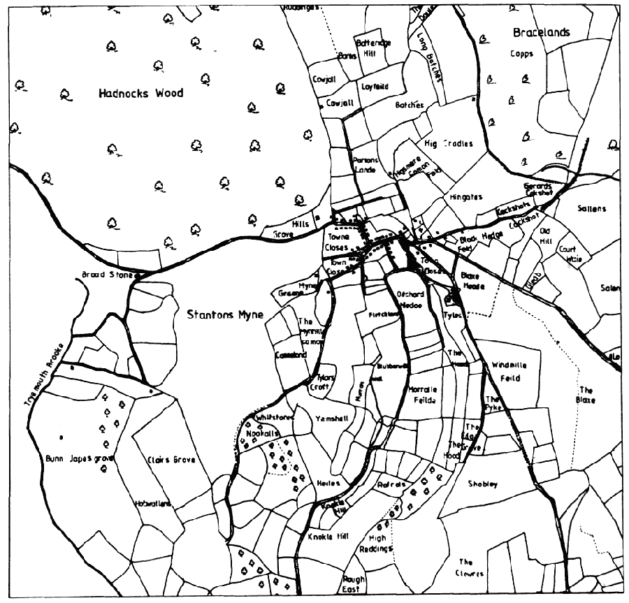
Staunton parish was compact in shape and covered 1,530 a. (fn. 9) (619 ha.). The south part of its east boundary followed an old road leading from Highmeadow towards Staunton village, and the north part of that boundary descended Whippington brook, recorded as 'Wybaltunes' brook in 1282. (fn. 10) The north boundary left the brook above its confluence with the Wye to run westwards to an oak tree, called Bellman's Oak in 1653, (fn. 11) and the west boundary, adjoining land that until the 16th century formed part of the marcher lordship of Monmouth and thereafter was in Monmouthshire, climbed a track to the old course of the Gloucester-Monmouth road at a place that was called Staunton gate in 1300. The boundary then followed the road down to a stone called the Broad stone and descended a brook, called Threbrook in 1300 (fn. 12) and later Try mouth brook or Grange brook, (fn. 13) to its confluence with the upper Red brook. The south boundary of the parish followed the Monmouth-Newland road up towards Highmeadow.
The parish is on part of an irregular spur of land, formed of carboniferous limestone, (fn. 14) and is mostly at over 150 m.; Staunton village is situated at c. 210 m. and the highest point of the parish, a ridge on the west crowned by the stone called the Buck stone, reaches 279 m. In the south part of the parish a narrow valley divides the Buck stone ridge on the west from a slightly lower ridge on the east and runs down into the deep valley of the upper Red brook.
In 1608 much of the high west ridge was waste land called Staunton Meend, covering 123 a. (fn. 15) A part of it, or possibly the whole, was evidently the land called Staunton Meend Ridges which, with other land called Knockalls further south, was granted by the Crown in fee in 1629 to the Hall family, (fn. 16) owners of Staunton manor and the large Highmeadow estate. Later the western slopes, towards Monmouthshire, belonged to the estate as a several wood called Rodge wood, while the eastern slopes, above the village and central valley, retained the name Staunton Meend and were manorial waste, commonable to the tenants. The common covered 42 a. in 1792. (fn. 17) Considerable areas of the parish were too steep for cultivation and remained woodland. (fn. 18) In 1792 there were 455 a. of woods in the parish, all belonging to the Highmeadow estate; the main woods were then Rodge wood, Patches wood at the north end of the parish, Bunjups, Knockalls, and Birchen groves on the south-west slopes above the upper Red brook, and the Hoods on the east side of the central valley. The owner of the estate then had a dwelling for his woodman at Reddings, on the north-west boundary between Patches wood and his large Hadnock wood in Monmouthshire. (fn. 19) Less steep ground, north of the village, on the ridge south-east of it, and in the valley south of it, was farmland and included some open fields until the early 17th century. (fn. 20)
Between 1823 and 1827 the Crown Commissioners of Woods, who had bought the Highmeadow estate, planted c. 550 a. of Staunton's farmland as part of the policy of raising oaks for future naval requirements. The ancient woods at Patches and above the Red brook valley were considerably enlarged but the principal new plantations were on the high ground of the east part of the parish (fn. 21) where the old fields such as Blakes, Windmill field, Shobleys, and High Reddings were lost. The Crown woodlands were later administered as Reddings Inclosure, comprising the north end of the parish and the adjoining Hadnock wood with a woodman's lodge at the old building, Knockalls Inclosure, in the south of the parish with a lodge at the south end of Staunton Meend, and Marian's Inclosure, in the east of the parish and including also land in Coleford tithing. (fn. 22) In 1843 Staunton parish comprised 1,015 a. of old woods and new plantations, 407 a. of farmland, and 62 a. of commonable waste. (fn. 23) A quarry worked on the edge of the plantations north of Highmeadow removed a large part of the ridge there during the later 20th century. (fn. 24)
The first element in the name of the parish (O.E. stan) (fn. 25) probably refers to a rocky outcrop, called the Cliff or Toad's Mouth, (fn. 26) by the Gloucester-Monmouth road at the west end of Staunton village, but it is also appropriate to an area with several megaliths. The Long stone, so called by 1336, (fn. 27) is a pillar of rock beside the Gloucester-Monmouth road near the east boundary of the parish. The Broad stone, which as mentioned above was a boundary mark in 1300, (fn. 28) is the largest of several lumps of rock lying in the fields of Broadstone farm at the west side of the parish. The celebrated local landmark called the Buck stone (fn. 29) surmounts the ridge above Staunton Meend at a popular viewpoint over the Wye Valley. The stone tapers to a narrow base, which once enabled it to be rocked, though that was said to be no longer possible c. 1775. (fn. 30) Later the stone attracted attempts to topple it, a feat that was achieved in 1885 by a party of five travelling actors and a Monmouth innkeeper, with whom they were lodging. The stone split into several pieces, but at the expense of the Crown, the landowner, it was cemented together and secured in its place with an iron bar. (fn. 31)
The road from Coleford town to Monmouth, passing through the village, was included by Ogilby in 1675 as part of the main London to South Wales road. (fn. 32) From the mid 18th century, because of the difficulties of negotiating the long hill between the village and Monmouth bridge over the Wye, a road at the south edge of Staunton parish, running down the upper Red brook valley to the Wye, was the coaching route to Monmouth. (fn. 33) That road was made a turnpike west of the end of Highmeadow hamlet in 1755, (fn. 34) and the Forest of Dean turnpike Act in 1796 covered the road leading from Coleford town through Whitecliff and up Highmeadow's main street. (fn. 35) Under an Act of 1831, (fn. 36) however, the Monmouth trust turnpiked the road through Staunton village and much improved it. In the village, where the old course made two awkward, right-angled bends, it was replaced by a new line from south of the parish church to the more westerly of the bends. Also, as part of a new line down the long hill to the Wye, a higher and slightly more southerly course replaced the old hollow way that had followed the parish boundary as far as the Broad stone. (fn. 37) An improvement had already been made at the expense of the parish in 1824 when part of the crag called the Cliff at the west end of the village was blown up. (fn. 38) East of the village the road was turnpiked in 1831 by the Forest of Dean trust, (fn. 39) and in 1841 that trust built a new line via Berry Hill, replacing the route through Coleford town; it joined the old road near the Long stone just within Staunton's boundary. (fn. 40) The Monmouth trust, which had a tollhouse near the west end of the village, (fn. 41) was discontinued in 1878 (fn. 42) and the Forest trust in 1888. (fn. 43)
A road from Staunton village to English Bicknor, recorded in 1282, (fn. 44) led from near the church to cross Whippington brook near Coalpit Hill, and another, recorded from 1348, ran south-eastwards from the church over the ridge to Highmeadow. Another road branched from the Highmeadow road at a place on the ridge where a windmill stood and ran south by way of Ashridge Cross (at the later Cherry Orchard Farm) to Newland village; (fn. 45) it appears to have been abandoned north of Cherry Orchard by the late 18th century. (fn. 46) A road leading from Staunton village down the central valley to the upper Red brook valley was called Mill way in 1348 and later Mill Lane. (fn. 47) During 1823 and 1824 the parish considerably improved Mill Lane, which then gave the villagers access to the Monmouth turnpike. (fn. 48) Under an Act of 1856 the Monmouth trust built a new road branching out of Mill Lane and leading along the east side of the central valley to Cherry Orchard Farm. (fn. 49) Of the old roads, the Bicknor road remained in use only as a track for forestry vehicles in 1994, while the Highmeadow road could be traced only as a woodland ride and part, north of Highmeadow, had been quarried away.
A tramroad opened in 1812 to supply Forest coal to Monmouth followed the road from Newland village to Cherry Orchard and turned down the valley to Upper Redbrook hamlet. Most of its course was later followed by the Coleford-Monmouth railway, which operated between 1883 and 1916. A small station to serve Newland village was built just east of Cherry Orchard Farm (fn. 50) and adapted to form a house in the mid 20th century.
The old irregular course of the Gloucester-Monmouth road formed the main street of Staunton village. At the east end of the village, by the junction with the old roads from English Bicknor and Highmeadow, there was a village green, broadening towards its northern end, where it was known as the Butts. (fn. 51) The parish church and rectory stood on the east side of the green and at its south end was a cross, of which the stepped base survives. (fn. 52) The cross was mentioned in 1393, (fn. 53) and it was called the high cross in 1511 (fn. 54) in distinction from a cross which in 1608 stood further west at the first right-angled bend in the village street. (fn. 55) The western cross was later removed but the place was known as Lower Cross during the 18th and 19th centuries. (fn. 56) The village pound stood on the south-west part of the green until 1828 when a school was built on its site; (fn. 57) a new stone-walled pound was built south of the main street and survived in 1994. The medieval manor house, abandoned and ruined by the late 16th century, stood south of the green on land called Court Orchard, (fn. 58) and Staunton Farm, the village's principal farmhouse in modern times, was later built nearby, within the angle formed by the main street and the Highmeadow road.
Staunton Village Area, 1608
In 1608 the village comprised c. 50 houses: the street was closely built up between the green and the Cliff at the parish boundary and there were a few scattered dwellings east of the green. (fn. 59) During the 17th and 18th centuries the village contracted, losing most of its western houses and becoming concentrated in the part of the street between the green and Lower Cross; (fn. 60) nine houses were in decay in 1653 (fn. 61) and in 1769 there were 12 decayed houses or empty sites. (fn. 62) About 1710 Staunton parish, including also the few houses then remaining within it at Highmeadow or at other outlying sites, was said to contain 54 houses, (fn. 63) but in 1801 only 42 inhabited houses and four uninhabited were enumerated in the parish. (fn. 64) The new line of road built in 1831, bypassing the main part of the street, altered the pattern of the east end of Staunton village by removing part of the green and dividing the church and rectory and the Butts from the rest of the village. The new road was not built up, but a few houses were added to the village during the 19th century and the early 20th, including some on the main road west of the junction with the new road and others on a lane leading from Lower Cross towards Staunton Meend.
Staunton Farm is a small late 17th-century farmhouse, rubble built and gabled. Part of a cottage west of the old school is dated 1719, and a 17th-century cottage adjoins it. The east part of Staunton House, at Lower Cross, is of the late 18th century, and in the mid 19th century, probably when it was the home of Alexander Gibbon (d. 1870), a prominent resident of the village, (fn. 65) it was enlarged to form a long, low range of building. The other houses which survived until the 19th century were all rebuilt or remodelled. The Elms, a house built in the late 19th century, was a home for the elderly in 1994 and had a large recent extension. Whippington's Corner, a small estate built by West Dean rural district east of the church, was begun in 1950 and enlarged in 1956. (fn. 66) A small private estate was added on the north side of the village in the late 1980s.
The few outlying dwellings recorded in the north part of the parish included Broadstone (or Broadstones) Farm, a farmstead established before 1653 in a group of closes on the Monmouthshire boundary below Rodge wood. (fn. 67) The small farmhouse was altered and heavily restored in the mid 20th century. In 1622 another small farmstead called Hobwaldings (fn. 68) stood further south, between the farmland of Broadstone farm and Bunjups grove. The house was demolished before 1769 (fn. 69) and its site and lands were included in the new plantations in the 1820s.
The hamlet of Highmeadow, partly within the south boundary of Staunton and partly in the ancient parish of Newland, was established on the road between Whitecliff and Staunton village, where it runs up a coomb to emerge on the high ridge above the head of the upper Red brook valley. Highmeadow was settled by the beginning of the 14th century, (fn. 70) and three houses at Highmeadow Street were mentioned in 1368. (fn. 71) In the 1560s there were 14 or more families living at Highmeadow, (fn. 72) and in 1608 (fn. 73) the hamlet comprised 18 houses, straggling down the road from the crossroads at its higher, north-western end as far as a point marked in 1994 by the remains of a bridge of the Monmouth tramroad. From the higher part of the hamlet a lane, recorded from 1369 (fn. 74) and called Highmeadow way in 1608, ran down the hill to Newland village. From lower down the street another lane, which was once part of the main route betwen Coleford town and Newland village, (fn. 75) branched off to join Highmeadow way at a wayside cross called Hodgeway Cross. The Hall family had a large house at the junction of the main street and Highmeadow way in 1608, and the lower part of the hamlet included the home of another fairly prosperous family called Bell, (fn. 76) which gave its name to an adjoining small wood, Bell's grove. (fn. 77)
Highmeadow was transformed during the 17th century by the Hall family, which became owners of the whole hamlet. The Halls acquired several houses as part of a substantial purchase in 1599 and at least nine others by individual purchases between 1606 and 1641. (fn. 78) About 1670 Henry Benedict Hall built a large mansion at the top of the hamlet north-west of his old house, and it was perhaps then that the main street above the junction with the Coleford-Newland road was moved north-eastwards so that it ran clear of the buildings of the old house and made more room for a forecourt for the new mansion. (fn. 79) The mansion and its grounds covered the sites of several of the old houses and most of the others were evidently demolished or abandoned to decay at the same period, all the land around being formed into a large home farm. (fn. 80) In 1792 apart from the mansion and the Halls' old house and outbuildings the only houses in the street were one at the junction with the old Coleford- Newland road and one north of the mansion. (fn. 81) The mansion was demolished at the beginning of the 19th century. In 1994 part of the Halls' old house survived among the buildings of Highmeadow farm, (fn. 82) but a bungalow occupied by the farmer was then the only inhabited house.
Below Highmeadow, at the top of the upper Red brook valley, there was a small hamlet called Ashridge, possibly containing no more than three or four houses. The name Ashridge was used generally for the whole of the valley and the lower part, at Upper Redbrook hamlet, was once known as Ashridge Slade, (fn. 83) but as a settlement name Ashridge seems to have been limited to the area around the junction of the valley road with the road to Newland village. Two inhabitants of Ashridge were mentioned in 1309 and there were three or more houses in the 1440s, one of them described as at Ashridge Cross, (fn. 84) which was the name of the junction in 1653. (fn. 85) In the modern period the only dwelling there was a farmstead of the Highmeadow estate, known by 1738 as Cherry Orchard Farm. Its farmhouse, which stood south-west of the junction, (fn. 86) was a large range of building dating in part from the 17th century or earlier. (fn. 87) At the end of the 19th century, (fn. 88) however, a new square farmhouse was built further east, adjoining the Newland village road. The old farmhouse was occupied as farm buildings and a labourer's cottage in 1918, (fn. 89) and it was later demolished.
Staunton parish was said to contain c. 100 communicants in 1551, (fn. 90) 25 households in 1563, (fn. 91) and 40 families in 1650. (fn. 92) About 1710 the population was estimated at c. 220. (fn. 93) A population of only 159 was enumerated in 1801, rising to 204 by 1831. Numbers remained fairly static during the mid 19th century, but fell during the 1870s to 121 in 1881, the cause presumably as much a reduction of work in the maturing timber plantations as the onset of the agricultural depression. During the next 50 years the population fluctuated between 120 and 170, but there was a rise in the mid and later 20th century to reach 267 by 1991. (fn. 94)
In 1799 Staunton village had an inn called the Ostrich (fn. 95) on the west of Lower Cross. By 1832 its sign had changed to the Royal Oak, (fn. 96) under which it remained open until 1890 or later. (fn. 97) By 1813 the White Horse had opened in the west part of the village street, (fn. 98) which remained the main road after 1831. The White Horse, rebuilt in the late 19th century, was the only public house in 1994. The village schoolroom was used as a reading room after the school closed in 1911, (fn. 99) and it remained in use as the village hall in 1994.
From the 17th century Staunton parish was dominated by the Highmeadow estate, which was owned successively by the Hall and Gage families before being sold to the Crown in 1817. (fn. 100) In 1816 just after the duke of Wellington had visited Monmouth a rumour was current that the government might buy the estate as his reward from the nation. If a later anecdote, that the duke looked at the view over the Wye from Staunton and declared it too reminiscent of the Pyrenees, is true, the incident presumably occurred during the same visit. (fn. 101)
MANOR AND OTHER ESTATE.
In Edward the Confessor's reign Earl Godwin held a manor at Staunton, assessed at 1 hide and forming part of the Herefordshire hundred of Bromsash. Another manor of 1 hide in the same hundred, held by Brictric, appears to be associated by the Domesday account with Godwin's manor and may also have been at Staunton. By 1066 both those manors had reverted to waste and they remained so, as part of the Crown's Forest of Dean, in 1086. (fn. 102)
A new manor of STAUNTON later emerged from the Forest waste, possibly as part of the lordship of Monmouth, whose holder Baderon of Monmouth confirmed Staunton church to Monmouth priory in 1144. (fn. 103) By the 13th century Staunton formed part of the royal hundred or liberty of St. Briavels, its owners paying a chief rent to St. Briavels castle and having custody of a bailiwick in the demesne woodlands of the Forest. (fn. 104) The lords of Staunton were deprived of the bailiwick from 1250 until 1265 (fn. 105) and again from c. 1281 to 1290, (fn. 106) but afterwards Staunton bailiwick remained with the owners of the manor. (fn. 107)
A family which took its name from the place but during the 13th and 14th centuries used the alternative surname of Walding held Staunton manor during the Middle Ages. Henry of Staunton, who held a Forest bailiwick in 1199, (fn. 108) was evidently lord of the manor, and in 1220 and 1223 manor and bailiwick were held by Philip of Bampton (fn. 109) during the minority of Henry's heir. (fn. 110) The heir was presumably Richard of Staunton (or Walding) who had succeeded by 1234 (fn. 111) and died before 1265. During the minority of his grandson and heir Thomas, Richard's lands were granted to Walter Wyther, who granted his right in 1266 to Richard de la More. (fn. 112) Thomas of Staunton died seised of the manor in 1292, leaving his son John, a minor whose lands were later taken into the custody of John Botetourt, the constable of St. Briavels. (fn. 113) John of Staunton was lord in 1307 (fn. 114) and died in 1339, when his son Thomas, who was enfeoffed of part of the manor in his father's lifetime, succeeded. (fn. 115) Thomas (d. 1361) left a son John of Staunton, a minor, whose lands were in the custody of Richard des Armes for a few years from 1362. (fn. 116) John of Staunton held the manor in 1393 and 1420. (fn. 117) Richard Staunton held it in 1428 and 1443 (fn. 118) and was succeeded before 1454 (fn. 119) by his son Thomas Staunton (d. 1473); Thomas's widow Joan, who married Hugh Amondesham, retained it until 1487 or later. Thomas's son John, a minor at his father's death, (fn. 120) later succeeded and died in 1526, when the manor passed to his brother Thomas Staunton (fn. 121) (d. 1528). Thomas left an infant daughter Margaret, (fn. 122) and it was presumably the same Margaret who with her husband Robert Saunders sold the manor in 1539 to Henry Brayne of Bristol. (fn. 123)
Henry Brayne (d. 1558) was succeeded by his son Robert (fn. 124) (d. 1570) who settled Staunton on his wife Goodith as jointure. (fn. 125) Goodith married John Seymour (d. by 1601) and retained the manor until 1608 or later. (fn. 126) It passed in moieties to Charles Gerrard, grandson of Sir Charles Somerset and his wife Emme, and John Winter, son of George Winter and his wife Anne; Emme and Anne were sisters and coheirs of Robert Brayne. (fn. 127) Charles Gerrard, who was knighted, sold his moiety in 1620 to Benedict Hall of Highmeadow, (fn. 128) and John Winter (d. 1619) was succeeded by his son George, (fn. 129) who sold his moiety to Hall in 1620. (fn. 130) Staunton manor then descended as part of the Highmeadow estate. The manorial rights belonged to the Crown from its purchase of that estate in 1817, (fn. 131) and in 1994 they were under the management of the Forestry Commission. (fn. 132)
The manor house of the Staunton family, recorded in 1295, (fn. 133) stood in the village on land later called Court Orchard, south of Staunton Farm by the entrance of the Highmeadow road. It was in ruins by 1579, (fn. 134) and some remains were still visible c. 1710. (fn. 135) A feature known as Castle ditch in 1698, near the west end of Court Orchard, was possibly the remains of a moat. (fn. 136) In the mid 17th century Court Orchard became part of the glebe by an exchange of land between the Halls and the rector. (fn. 137)
The HIGHMEADOW estate, which became one of the largest in the Forest area, was built up by the Hall family. The Halls were recorded at Highmeadow from the 13th century, (fn. 138) and they acquired land in the area throughout the 16th century and the early 17th, their largest purchases being in the 1620s and 1630s. (fn. 139) Henry Hall of Highmeadow died in 1518. (fn. 140) William Hall (d. 1545) of Highmeadow was succeeded by his son Christopher (fn. 141) (fl. 1595) (fn. 142) and Christopher by his son William. William's purchases included an estate bought from Richard Hyett in 1599, (fn. 143) which was probably that in Newland and Staunton once owned by Alexander Baynham (d. 1524) and his son John, (fn. 144) lords of Mitcheldean; Alexander's grandfather Robert Baynham had owned property at Highmeadow in 1423. (fn. 145)
William Hall died in 1615 and his son and successor Benedict (fn. 146) was said to have 800 a. in Newland and Staunton parishes in 1619. (fn. 147) He added Staunton manor in 1620 (fn. 148) and English Bicknor manor in 1633. (fn. 149) Benedict Hall was a Roman Catholic and was sequestrated for recusancy before 1650 and did not recover his estates until 1656 or later. (fn. 150) He died in 1668 and was succeeded by his son Henry Benedict Hall (fn. 151) (d. 1691), whose son and successor Benedict (fn. 152) died c. 1720. Benedict's heir was his daughter Benedicta Maria Theresa, the wife of Thomas Gage. (fn. 153) Gage, who was created Viscount Gage in the peerage of Ireland in 1720, sat as M.P. for Tewkesbury 1721-54. He was succeeded at his death in 1754 by his son William Hall Gage, who added the barony of Gage of Highmeadow to his titles in 1790. William (d. 1791) was succeeded by his nephew Henry Gage (d. 1808) and Henry by his son Henry Hall Gage. (fn. 154) The 4th Viscount sold the Highmeadow estate to the Crown Commissioners of Woods in 1817. It then covered 4,257 a., including seven farms in Staunton, Newland, and English Bicknor parishes, the woods of Hadnock, Monmouthshire, and of Mailscot, and mills and ironworks at Lydbrook and Redbrook. (fn. 155) During the next few years the Crown sold parts of the estate, (fn. 156) retaining c. 3,400 a., comprising the old woods and farmland which it turned over to timber production. The Crown estate, usually known collectively as Highmeadow woods, was subsequently managed with the Forest of Dean and was transferred with the Forest to the Forestry Commission in 1924. (fn. 157)
The south end of the Highmeadow estate, comprising 395 a. of farmland based on Highmeadow and Cherry Orchard Farms, was sold by the Crown in 1825 to Sir Robert Inglis, Bt. (fn. 158) Inglis offered it for sale in 1836, (fn. 159) and it was bought then or soon afterwards by George Bengough, of the Ridge, Wotton under Edge. (fn. 160) George (d. 1856) was succeeded in turn by his sons George Henry (d. 1865) and John Charles (d. 1913), and it was among extensive Gloucestershire estates put up for sale by John's grandson, Nigel James Bengough, in 1918. It was bought then by the tenant H. J. Smith, (fn. 161) whose family remained owners until the mid 20th century when the two farms were sold as separate units. (fn. 162)
In 1608 the Halls' house at Highmeadow was a large dwelling with outbuildings at the junction of the Whitecliff-Staunton road and the lane from Newland village, near the higher end of what was then a considerable hamlet. (fn. 163) Before 1672 Henry Benedict Hall built a large mansion (fn. 164) north-west of the old house on the edge of a ridge which commanded wide views over the Wye Valley. The building of the mansion involved terracing the ground, and probably the demolition of several small houses at the upper end of the hamlet. (fn. 165) Highmeadow House, 164 ft. long and of two storeys with dormered attics and cellars below, was built on an H plan with a central double-depth range of nine bays and projecting end wings. Both the west front, facing the valley, and the east front to the road were given elaborate formal treatment and were approached by flights of steps extending across the full width of the recesses between the wings. On the ground floor a central entrance hall was entered from an axial screens passage built across the end of another hall-like room, and on the floor above the full depth of one of the side wings was occupied by a long gallery. On the east front a railed forecourt with a circular carriage drive was formed, with a walled outer court. (fn. 166) During the 18th century the house was used ocasionally by the Gages, whose principal residence was at Firle (Suss.). By 1805 they had given up Highmeadow, which then or soon afterwards was dismantled and the materials sold piecemeal. (fn. 167) In 1994 the site was still marked by a turf-covered heap of rubble, and remains of the cellars survived below ground and remains of the forecourt walling above.
The Halls' old house remained in use as a farmhouse during the 18th century and was known as Highmeadow Lower House. (fn. 168) During the 19th and early 20th centuries when Highmeadow and Cherry Orchard farms were a single tenancy Cherry Orchard was the principal farmhouse, and by 1918 the old house at Highmeadow had been divided into two farm cottages. (fn. 169) From the early 1930s the two farms were managed separately and the farmers of Highmeadow lived in a bungalow built west of the farm buildings on the lane to Newland. (fn. 170) One range of the old house survived in use as a farm building in 1994. It retains some late-medieval windows, probably reset, and the massive, carved supports of a porch roof.
ECONOMIC HISTORY.
In 1295 only 30 a. of arable, ½ a. of meadow, and 1½ a. of wood were recorded in demesne on Staunton manor, (fn. 171) but in 1342 the demesne was extended at 1 ploughland and 80 a., with 20 a. of meadow, 6 a. of pasture, and 12 a. of wood. (fn. 172) In 1579 the manor had a large demesne estate, mainly in closes in the area south of the village and old manor house but also including some large outlying groves and closes. (fn. 173) By 1608 the demesne estate was challenged in size by the expanding Highmeadow estate, whose owner William Hall was then also tenant of some parts of the demesne. (fn. 174) After Benedict Hall acquired the manor in 1620 most of the farmland of Staunton parish belonged to the Highmeadow estate.
In 1295 the manor received 24s. 1d. in rent from free tenants and 13s. for the rent, works, and fines of customary tenants, (fn. 175) and in 1342 the rent from its tenants amounted to 120s. (fn. 176) No customary tenancies were recorded after the Middle Ages, but only free tenancies, most of which comprised no more than houses, gardens, and orchards. In 1579 47 holdings, 38 of them including dwellings, owed chief rent to the manor. (fn. 177) In 1653 there were 33 free tenants with between them a total of 43 houses, 9 of which were in decay. The manor also had some free tenants in a part of Coleford tithing that was claimed to belong to it and one or two others in adjoining parts of Hadnock. (fn. 178) By 1769 further amalgamations of holdings had reduced the number of free tenants to 23 and the number of inhabited houses to 25. Tenants with houses or sites of former houses owed a heriot, which might be commuted for two years' chief rent, and a relief of two years' chief rent was owed at an alienation. By 1769 a number of people occupied encroachments on Staunton Meend, (fn. 179) for which small rents were later levied. In 1817 a larger number of encroachments on the waste in Coleford also owed rents to the manor, and many more, not yet charged with rent, had been established there in the previous few years. The rents of all the free tenants of Staunton manor amounted to £2 15s. 5d. in 1817, with a further sum of £8-9 received for the encroachments. (fn. 180) Most rents and payments for encroachments in Staunton and Coleford were redeemed in the 1860s and 1880s, (fn. 181) and in 1891 there were said to be no more than three free tenants of the manor, only one of whom was resident. (fn. 182)
On the south boundary of the parish at Highmeadow and Ashridge there was a similar pattern of small freehold tenancies until the early 17th century. (fn. 183) After the Halls acquired all the surrounding land and most of the houses were demolished or left to decay, that area comprised only the two farms of Highmeadow and Cherry Orchard. (fn. 184)
In the 13th and 14th centuries the parish had a number of open fields, holdings in which were sometimes called dietae, presumably units of land that needed a day to plough. (fn. 185) Morewall (later Morrall) field lay in the valley, beside Mill Lane, Shobleys field lay in the fork of the roads leading to Highmeadow and Cherry Orchard on the high land (later planted) near the east side of the parish, and Windmill field adjoined the Highmeadow road north of Shobleys. (fn. 186) An open field called Clowers (or Clore) was apparently near the head of the upper Red brook valley, on the north side of the Newland-Redbrook road, though in the 17th century there was other land of the same name on the ridge south of Shobleys. (fn. 187) North of the village on the slopes descending to the Wye lay Heymere field, possibly that called Staunton field c. 1300, and further down the hill was Ley field. (fn. 188) Inclosure of the open fields was evidently well under way by 1579 when the manorial demesne included lands called the great piece in Morrall field and the great piece in Ley field. (fn. 189) In 1608 Morrall, Ley, and Windmill fields were closes on the manorial demesne and Shobleys and Clowers were closes on the Highmeadow estate. Heymere then remained an open field, (fn. 190) and the sale of 9 a. there to Benedict Hall in 1632 may have marked the end of the process of inclosure. (fn. 191) The inhabitants of Staunton enjoyed common rights on Staunton Meend and other much smaller parcels of waste. With the other parishes of the area they also had common in the Crown demesne lands of the Forest. (fn. 192) The parishioners paid herbage money for the same to the lessee of the St. Briavels castle estate until the 1830s, (fn. 193) but their rights were perhaps little exercised after 1625 when the sale of Mailscot wood (fn. 194) deprived them of the use of the only large tract of demesne woodland adjoining the parish. Staunton Meend remained common land in 1994 when two villagers pastured horses there; the right of soil had been bought by the parish council from the Forestry Commission for a nominal sum. (fn. 195)
In the early 17th century much of the Halls' estate was kept in hand and used as sheep (fn. 196) and cow pasture. In 1655 the estate included a 100-acre sheep walk on the ridge above the Newland-Monmouth road and smaller sheep pastures at the former Windmill field and at the Hays, above and east of Highmeadow. (fn. 197) By the late 18th century most of the farmland of the estate in the Staunton area was organized as three tenant farms. In 1792 Staunton farm, based at the farmhouse in the village, had 280 a., mainly lying in the valley south of the village and on the ridge to the south-east. Cherry Orchard farm, with its farmhouse beside the Newland-Monmouth road at the south boundary of the parish, had 358 a. (including 145 a. in Newland), lying along the road and on the ridge to the north. The cherry orchard from which it took its name then covered 16 a. on the north side of the road. Highmeadow farm, based on the old house near the owner's mansion, had 291 a. (mainly within Newland), lying around Highmeadow hamlet and in Coleford tithing to the north. The three large farms and a few small holdings in Staunton were held on leases, which were renewed for 16 years from 1793. In the north part of Staunton parish there were also a few freehold farms, all of under 60 a. In 1792 the 929 a. on the three big farms included 392 a. of arable, (fn. 198) and in Staunton parish in 1801 239 a. were returned as under crops, mainly wheat and barley. (fn. 199)
Following the establishment of the new timber plantations in the 1820s, only c. 400 a. of farmland remained in Staunton parish. In 1843 the surviving farmland of the south part of the parish, 141 a., belonged to Cherry Orchard and Highmeadow farms, (fn. 200) which had another 175 a. in Newland parish. (fn. 201) The two farms, which formed a single tenancy from the early 19th century to the early 20th, (fn. 202) had a preponderance of arable over pasture in the mid 19th century (fn. 203) and in 1851 employed 12 farm labourers, some of them living in at Cherry Orchard. (fn. 204) In 1918 about two thirds of the acreage was pasture and the buildings at both sites mainly cattlesheds. (fn. 205) In 1994, when they were separate freehold farms, Highmeadow supported a flock of over 1,000 sheep and Cherry Orchard had a dairy herd of 90 cows. (fn. 206)
Of the farms based in the village in 1843 only Staunton farm (then known as Hill farm), with 89 a., was more than a smallholding. Broadstone farm then had 114 a., lying around its farmhouse, below the woods on the Monmouthshire boundary, or in the central valley, where a barn became known as Partridge's barn from the mid 19th-century owners. (fn. 207) In 1866 on those two farms and the smaller holdings 119 a. of arable, rotating wheat, barley, roots, and clover, and 77 a. of permanent grass were returned. The livestock returned were 576 sheep and 23 cattle. (fn. 208) In 1926 in the north parts of the parish there remained only two farms of more than 50 a. and five smallholdings, employing between them a total of six farm labourers. The amount of arable returned had fallen to 70 a. and there had been an increase in the cattle kept for dairying. (fn. 209) In 1988 only 8 ha. (20 a.) of land was returned as cropped, and the one farm then worked full-time and four part-time holdings raised cattle and sheep. (fn. 210)
A windmill recorded on the manorial demesne from 1342 (fn. 211) stood on the ridge near the Staunton- Highmeadow road and gave its name to Windmill field. It was in ruins in 1579. (fn. 212) The village was later served by corn mills on the upper Red brook at the south edge of the parish (fn. 213) and the lane leading to them became known as Mill Lane. (fn. 214)
Henry II licensed a forge at Staunton, (fn. 215) and in 1282 10 Staunton men were working movable forges in the area. (fn. 216) In 1437, however, only a single forge was recorded at Staunton among those in the Forest parishes owing payments to the Crown. (fn. 217) A building called an 'oresmith' stood in or near the village in 1484 (fn. 218) and another adjoined a house at Highmeadow in 1521. (fn. 219) A smith-holder of Highmeadow leased land and the right to cut underwood for charcoaling from the lord of Staunton manor in 1553. (fn. 220) Heaps of cinders left by the medieval ironworkers were later found in several parts of Staunton village. (fn. 221) A blast furnace which in 1608 stood near the Newland-Monmouth road within the parish boundary is mentioned above with the history of the ironworks of the Highmeadow estate at Upper Redbrook. (fn. 222)
Deposits of iron ore in the parish were presumably being dug in 1608 when four miners were recorded. (fn. 223) Small mines were worked during the 18th century and c. 1770 were said to provide the chief employment for the labouring class. (fn. 224) In 1859 a miner took a gale for working ore east of the village between the Coleford road and the old road to Bicknor and a mine opened there was worked until 1874. (fn. 225) Robinhood mine near the parish boundary south-west of the Coleford road, presumably so called because it was in the plantation called Marian's Inclosure, (fn. 226) was opened in 1871. (fn. 227) It was described as a colour mine in 1889 (fn. 228) and for many years was worked mainly for red oxide. For several years before its closure in 1932, however, it produced iron ore only. It was worked again by the Ministry of Supply during the Second World War, (fn. 229) and ruins of buildings remained in 1994.
Lime burning was a trade in the parish by 1608. (fn. 230) In 1664 there was a limekiln on waste land near the church, (fn. 231) and in 1792 one stood at a quarry at Tillys, south-east of the village below the Staunton-Highmeadow road. Two others, belonging to Cherry Orchard farm, stood at a quarry on the ridge to the north-east of the farm in 1792, (fn. 232) and the exaggerated claim was made in 1803 that they supplied most of Herefordshire and Monmouthshire. (fn. 233) They had gone out of use by 1880 when there were other kilns on the farm's land beside the old tramroad near the head of the upper Red brook and others on Highmeadow farm east of Highmeadow's street. (fn. 234) Three limekilns were worked at Tillys in the late 19th century. (fn. 235) From the 1950s the quarry on the ridge above Cherry Orchard Farm was worked for roadstone. (fn. 236) By 1994, when it was operated by Tarmac Ltd., it had been greatly enlarged and a new access road, made through the woods to the Coleford-Monmouth road, carried constant lorry traffic.
During the 17th and 18th centuries much of the woodland of the Highmeadow estate in Staunton and adjoining parishes was probably managed as coppice, for it provided regular allowances of cordwood to the lessees of the estate's ironworks at Redbrook and Lydbrook. (fn. 237) Wood for barrel making was also cut and sent by water to Bristol in the late 18th century. (fn. 238) There were, however, some large timber oaks in the woods at the beginning of the 19th century, when many were felled and sold to a Monmouth timber merchant. (fn. 239) From the 1820s, when the plantations for navy timber were made, until the early 20th century the Crown woodlands were the main source of employment in Staunton parish. (fn. 240) In 1851 the inhabitants included 2 woodwards, a woodman, and 11 woodcutters. (fn. 241)
Three smiths, a carpenter, and a tiler recorded at Staunton in 1608 were probably based in the village, (fn. 242) though Highmeadow hamlet also had a few tradesmen at the period: a blacksmith of Highmeadow was mentioned in 1560, two tailors later in the 16th century, and a carpenter in 1639. (fn. 243) In 1851, apart from those employed in the woods, 12 non-agricultural tradesmen were recorded in Staunton parish, including a grocer, a tailor, a blacksmith, and 3 shoemakers. (fn. 244) A boot repairer recorded in 1939 was one of the last representatives of traditional village trades. There were then two guest houses and a small hotel in the village, (fn. 245) which was situated on a main motoring route and in a popular tourist area. The village had one or two small shops during the later 19th century and the earlier 20th (fn. 246) but in 1994 its only shop was one attached to a petrol station.
LOCAL GOVERNMENT.
Records of courts baron with courts of survey for Staunton manor survive for 1653 (fn. 247) and 1769 and of courts baron for 1774 and 1780, (fn. 248) and there are records for courts held in the late 19th century and early 20th. (fn. 249) In 1774 the court met in Staunton village, (fn. 250) but in 1803 and later it was held at the Angel inn, (fn. 251) in the part of Coleford town that was claimed to belong to the manor. In the late 19th century and early 20th it was convened only every seven years, the last time apparently being in 1912. In those last sessions the deputy surveyor of the Forest usually acted as steward under the Crown and the business comprised a perambulation of the manor and some presentments of encroachments and of the deaths of free tenants. The court styled itself a leet by the 1860s, (fn. 252) though leet jurisdiction over Staunton had earlier been exercised by the hundred court held at St. Briavels castle. (fn. 253)
The parish had two churchwardens in 1572, (fn. 254) and there were later also two overseers of the poor, whose accounts survive for the years 1803- 18, (fn. 255) and two surveyors of the highways, whose accounts survive for 1774-1826. (fn. 256) The administration of poor relief in the village was on a small scale, probably with no expedients necessary beyond weekly doles to the few disabled or unemployed villagers. At the beginning of the 19th century the annual cost rarely exceeded £100, with no more than c. 12 people receiving regular weekly pay, (fn. 257) and the cost rose only to a peak of £146 during the late 1820s and early 1830s. (fn. 258) Staunton was included in the Monmouth poor-law union in 1836. (fn. 259) In 1894 it became part of the West Dean rural district (fn. 260) and was included in the Forest of Dean district from 1974.
CHURCH.
A church was recorded at Staunton from 1144 when Baderon of Monmouth confirmed it to Monmouth priory, a cell of St. Florent abbey (Saumur). The record of the confirmation in the abbey's cartulary implied that the church was given to the priory by its founder Wihanoc of Monmouth, who died or resigned his estates before 1086, but since Staunton was waste during the Conqueror's reign that seems unlikely. (fn. 261) The grantor, and perhaps builder of the church, was more likely Baderon himself or his immediate predecessor in the lordship of Monmouth, William son of Baderon. (fn. 262) The living of Staunton was a rectory in 1269 (fn. 263) and has remained one. In 1922 it was united with the vicarage of Coleford. (fn. 264)
Monmouth priory's right to the church was confirmed by papal bull in 1186 (fn. 265) but it was apparently challenged in King John's reign. (fn. 266) The priory successfully presented to the rectory in 1270 and 1303, (fn. 267) but the guardian of the heir to Staunton manor was claiming the advowson against the priory in 1269, (fn. 268) and in 1317 the lord of the manor, John of Staunton, presented. (fn. 269) In 1365 the Crown presented during the minority of the heir to the manor (fn. 270) and it presented again in 1383. (fn. 271) In 1394 John of Staunton (or Walding), the lord of the manor, presented, (fn. 272) and the advowson later remained with the manor, although the bishop collated to the living in 1582, and in 1655, while Benedict Hall's estate was in sequestration, the Lord Protector presented. The Halls, though Roman Catholics, exercised the advowson several times during the 1660s and 1670s. (fn. 273) The 4th Viscount Gage reserved the advowson when he sold his estate, and in 1830 sold it to Edward Machen (d. 1862). It passed to Edward's son Edward (d. 1893), rector of Staunton, and then to the Revd. Edward's son Charles (d. 1917), whose heir (fn. 274) transferred it in 1917 to the bishop. (fn. 275)
The rector of Staunton's glebe land, a few closes adjoining the village, was extended at 11½ a. in 1678 (fn. 276) and at 12 a. in 1843. (fn. 277) By an arrangement made before 1655 (fn. 278) and still in force in 1680, the Halls paid the rector a composition of £12 a year for the tithes from their demesne lands in the parish. The smaller occupiers paid most of their tithes in kind in 1680, though there were cash payments for gardens, cows, calves and colts, and for horses used to carry charcoal or iron ore. (fn. 279) In the 1820s when the Crown planted 550 a. of the farmland with timber the rector Richard Davies sought compensation for his tithes, estimated to be reduced from 5s. 6d. an acre to 1s. an acre, (fn. 280) and by 1828 he was receiving an annual payment from the Commissioners of Woods to cover the balance. (fn. 281) In 1843 the tithes of the parish were commuted for a corn rent charge of £147 5s. 2d., only £62 3s. of it coming from the two thirds occupied by the Crown's old woodland and new plantations. (fn. 282) The compensation was continued until Davies's death in 1857 but it was refused to his successor. (fn. 283) The tithe rent charge for the Crown woodlands was redeemed in 1920. (fn. 284)
The rectory house, standing on the north side of the churchyard, contained five rooms on the ground floor and five on the first floor in 1698. (fn. 285) The rector Thomas Mallet rebuilt it c. 1814, (fn. 286) and it was extended to the north-west in the late 1850s by the rector Edward Machen, using part of a legacy left for that purpose by his uncle and predecessor, Richard Davies. (fn. 287) It was sold and converted to flats after the union of the benefices in 1922, the incumbent living at Coleford. (fn. 288)
The rectory was valued at £6 13s. 4d. in 1291, and a portion valued at 4s., presumably awarded under a settlement of the dispute over the advowson, was held by the prior of Monmouth then (fn. 289) and until the Dissolution. In 1535 the rectory was valued at £6 11s. (fn. 290) It was worth £39 in 1650, (fn. 291) £70 in 1750, (fn. 292) £200 in 1814, (fn. 293) and £253 in 1856. (fn. 294)
Stephen Askeby, rector of Staunton in 1277, had licence to study for a year at Paris. (fn. 295) Roger Winter, rector 1538-82 (fn. 296) and also vicar of Woolaston, (fn. 297) was found to be unable to repeat the Commandments in 1551, and though he could repeat the articles of the Creed he would not accept that they could be proved from Scripture but only by the authority of the Church. (fn. 298) His successor John Trubshaw, 1582-94, (fn. 299) was also a pluralist and in 1593 was among Gloucestershire incumbents categorized as 'slender scholars and of life suspected'. (fn. 300) Francis Hampton, rector from 1629, retained the living until his death in 1654. (fn. 301) Charles Godwin subscribed as rector in 1662 and was succeeded in 1664 by William Hughes, (fn. 302) who held the living in plurality with Newland (fn. 303) until 1670. In 1703, in the incumbency of William Harrison 1679-1724, the churchwardens reported that their rector was a man of sober life and orthodox principles, that there were no immoral or disorderly parishioners, and that the church was in good repair. Thomas Hill, rector 1727-64, was also vicar of Llanarth (Mon.). (fn. 304) William Barnes, rector c. 1765 (fn. 305) -1813, resided at Monmouth in 1786 and in 1808, when he claimed that Staunton's exposed situation and cold climate would endanger his health. (fn. 306) Thomas Mallet, 1813-22, was also vicar of Dixton Newton (Mon.); his successor Richard Davies (fn. 307) served Dixton until 1833. (fn. 308) Davies, whose father James Davies of Eastbach Court, English Bicknor, had been Lord Gage's local agent, (fn. 309) had taken orders in expectation of the living of Staunton. (fn. 310) At his death in 1857 his brother Edward Machen, the new patron, presented his own son Edward, who served until 1874. (fn. 311)
A chapel of St. John the Baptist stood near the village in 1368, (fn. 312) but no further record of it has been found. Its site was presumably at or near St. John the Baptist's well on the north side of the main road, near the Monmouthshire boundary. (fn. 313)
The church of ALL SAINTS was so called by 1735 (fn. 314) but had a dedication to St. Nicholas in 1144 (fn. 315) and until 1403 or later. (fn. 316) It is built of rubble and ashlar and has chancel, central tower with transepts, and aisled nave with south porch.
The tower, nave, and north arcade are of the 12th century, and the chancel was rebuilt and the transepts and south aisle added in the 13th. In the 14th century the south aisle was widened to align with the south wall of the south transept, and there was a similar enlargement of the north aisle in the 15th century; the west walls of both transepts were removed to unite them with the aisles. In the 15th century the top stage of the tower was added and the nave was given a new west window. At an unknown date, presumably after the early 16th century, the three western bays of the north aisle were demolished and that part of the arcade incorporated in a new nave north wall.
By the late 17th century the south transept was screened off from the south aisle to form a manorial chapel, (fn. 317) but in the 1820s it was being used as a vestry and schoolroom. (fn. 318) The north transept was known as Higgins chancel in the late 18th century from a family of freehold tenants whose members were buried there. (fn. 319) In the early 19th century the church had the usual Georgian fittings, including lath and plaster ceilings, a three-decker pulpit, and Commandments boards on each side of the east window. (fn. 320) During alterations in the early 1860s, made mainly at the cost of a local resident, the Revd. James Hammond, stained glass was put into several windows and an organ was provided; at his death in 1871 (fn. 321) Hammond left £100 stock to help provide a salary for the organist. (fn. 322) In 1872 the church was restored to the plans of J. W. Hugall, the cost met mainly by a legacy given to the parish by the former rector Richard Davies, supplemented by members of his family, and a grant from the Crown as lord of the manor. (fn. 323) The south transept was then remodelled: its roof, which had been ridged east-west, was rebuilt with a north-south ridge, its east and south windows were exchanged to fit the new form, and its south doorway was moved to the north side of the chancel to serve as a priest's door. At the same time the nave was reroofed, the columns of the south arcade were straightened and their bases renewed, the church was repewed and refitted, and the north transept was screened off to form a vestry. About 1905 the north transept was restored for use as a chapel, while the south transept became the vestry and organ chamber. (fn. 324)
A late 15th-century stone pulpit is incorporated in the rood stair at the east end of the north arcade. The Norman font is a cube of stone, once thought to have been a Roman altar, hollowed out and given a band of pellet decoration. (fn. 325) It was presumably replaced in the 14th century by the octagonal font of that period which also survives in the church. (fn. 326) About 1830 the early font was standing outside to catch rainwater from a roof-spout and was moved inside; it, and the ancient pulpit, were returned to use at the restoration of 1872. (fn. 327) The church had a ring of four bells at the beginning of the 18th century, (fn. 328) two of them medieval bells and one cast by John Pennington in 1623. In 1862, by G. Mears & Co. and at the cost of James Hammond, the Machen family, and another parishioner Samuel Harris, three of the old bells, which had cracked, were recast and two new bells were added to the ring. The fourth old bell was recast in 1915. (fn. 329) A set of plate dated 1684, comprising chalice, paten cover, and credence paten, was given to the church by the lord of the manor Henry Benedict Hall. (fn. 330) The parish registers survive from 1653. (fn. 331)
NONCONFORMITY.
The Halls of Highmeadow were Roman Catholics and they presumably encouraged the survival of Catholicism in Staunton. Eleven Catholics, apart from Benedict Hall and two of his family, were listed there c. 1720. (fn. 332) A Jesuit priest lived at Cherry Orchard Farm in the late 1760s. (fn. 333)
In 1735 five Anabaptists were recorded at Staunton. (fn. 334) A Methodist society meeting at Coleford had adherents at Staunton from the late 1780s. It was probably that group that registered a house at Staunton in 1796, and in the early 19th century it met at the house of Richard Morgan. (fn. 335) There was perhaps another group of dissenters in the village c. 1825 when two houses were in use for worship, (fn. 336) but in the later 19th century local dissenters presumably attended chapels in Coleford.
EDUCATION.
In the early 19th century a parish day school was held in the south transept of Staunton church. (fn. 337) In 1819 20 children attended, 8 of them paid for by their parents and the rest educated free by the rector Thomas Mallet. Mallet also ran a Sunday school, attended by c. 70 children in 1819. (fn. 338) In 1828 a small single-room school was built near the east end of the main village street on a piece of manorial waste that the Crown conveyed in trust to the rector and churchwardens in 1859. (fn. 339) The school was affiliated to the National Society by 1847. In the 1830s and 1840s it was attended by c. 30 children. Some of the parents paid, the rate being 1s. a quarter in 1833, (fn. 340) but in the year 1875 only 11s. of c. £46 that it cost came from pence, the bulk being supplied by voluntary contributions. (fn. 341) During the last 20 years of the 19th century and the first decade of the 20th attendance was rarely more than c. 20 children, and the school was closed in 1911. (fn. 342) The village children subsequently went to school in Coleford, and the school building, which reverted to the Commissioners of Woods, became a village reading room. (fn. 343)
CHARITIES FOR THE POOR.
A house and 4 a. of land, the donor unknown, were applied to the use of the poor of Staunton parish. About 1820, by which time the house had fallen down, the land was exchanged with the Crown for a piece of manorial waste called Meend green, which produced a rent of £5 2s. (fn. 344)
Henry Hall (d. 1645), a son of William Hall of Highmeadow, left £40 a year, half for the poor of Staunton and half for the poor of Newland. His brother Benedict and nephew John Hall, (fn. 345) who were later credited as founders of the charity, charged the sum in 1657 on a farm at St. Weonards (Herefs.). (fn. 346) Staunton's share was presumably not distributed for some years, for by 1683 an accumulation of the charge, £100, was out on loan, and before 1705 £140, apparently from the same source, was secured on land called Braceland in English Bicknor. Another accumulation of the £20 a year was used before 1683 to buy a small house near the cross at the east end of the village for use as an almshouse. (fn. 347) In the mid 1820s the £20 and £7 a year charged on Braceland were distributed to the poor of the parish in general and the almshouse, which was managed by the same trustees, housed four people. It was then planned to apply the rent charges and the rent from Meend green to the maintenance of the almspeople, (fn. 348) and that was being done in 1896 when the whole was administered as a single charity. (fn. 349) In 1961 the trustees of the Hall charity mortgaged the almshouse to raise funds to renovate it, and in 1971 most of their income was applied to paying the interest, though some cash was distributed to poor widows. The two occupants of the almshouse then paid 5s. a week rent. (fn. 350)
Sarah Richards by will proved 1845 gave £100 to be invested in stock and the proceeds distributed to poor widows and widowers. In 1971 the £2 a year received was divided among four people. (fn. 351)
Plans made in 1976 to amalgamate the Staunton charities were not implemented, but they were administered as one in 1994. The almshouse, which was then occupied by a single tenant for a rent set at half the sum appropriate under the 'fair rent' scheme, was then undergoing further extensive repairs financed mainly by a local authority grant and an interest-free loan from the Almshouse Association. All the charity income, including also the small sum received for the Richards charity, the interest on £280 which had apparently been acquired with an accumulation of one of the Hall rent charges, and £200 rent for Meend green, was then being applied to the renovation project. (fn. 352)