A History of the County of Gloucester: Volume 6. Originally published by Victoria County History, London, 1965.
This free content was digitised by double rekeying. All rights reserved.
'Parishes: Stanway', in A History of the County of Gloucester: Volume 6, ed. C R Elrington (London, 1965), British History Online https://www.british-history.ac.uk/vch/glos/vol6/pp223-232 [accessed 30 April 2025].
'Parishes: Stanway', in A History of the County of Gloucester: Volume 6. Edited by C R Elrington (London, 1965), British History Online, accessed April 30, 2025, https://www.british-history.ac.uk/vch/glos/vol6/pp223-232.
"Parishes: Stanway". A History of the County of Gloucester: Volume 6. Ed. C R Elrington (London, 1965), British History Online. Web. 30 April 2025. https://www.british-history.ac.uk/vch/glos/vol6/pp223-232.
In this section
STANWAY
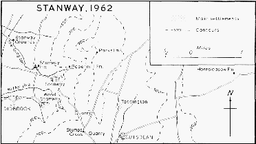
Stanway, 1962
The parish of Stanway lies on the north-western edge of the Cotswolds, 11 miles east of Tewkesbury and four miles north-east of Winchcombe. The name is derived from an ancient road passing through Stanway village which has been variously identified as the road from Tewkesbury to Stow-on-the-Wold, going up Stanway Hill, (fn. 1) and as the ancient route from Droitwich to Cirencester, (fn. 2) a salt-way linking Stanton, Stanway, Didbrook, and Hailes. (fn. 3)
The parish includes the hamlets of Wood Stanway (a mile south of Stanway village) and Taddington (two and a half miles to the east). It was c. 3,300 a. in area (fn. 4) and very irregular in shape before its boundaries were changed in 1883 and 1935. Taddington, which forms a narrow projection eastwards between the parishes of Cutsdean and Snowshill, may have been a separate unit which became part of Stanway because like Stanway it belonged to Tewkesbury Abbey; an agreement of 1196 suggests that the tenurial boundaries in that area were not clearly drawn in the 12th century. (fn. 5) In 1883 570 a. of Didbrook, including Upper and Lower Coscombe, was transferred to Stanway. (fn. 6) In 1935 the narrow eastern projection of Stanway, comprising 1,139 a., was transferred to Cutsdean, and 1,396 a. from Hailes parish and 402 a. from Didbrook (including the village) were transferred to Stanway, which was thus 4,519 a. in area. (fn. 7)
The account given here relates to the area of the parish as it was up to 1883. The eastern projection followed, roughly, the line of Upper Slatepits Plantation in the north as far as Bourton Downs, and in the south it followed the road to Hornsleasow Farm from Ling Ground Plantation to the stream (the main feeder of the River Windrush) at Taddington. (fn. 8) The boundary followed the stream south as far as Cutsdean village and then ran west to meet the road from Stow at Stumps Cross. It followed that road north of Lower Coscombe, and then turned south-west along field boundaries towards Beckbury Camp. (fn. 9) The west boundary followed field and plantation boundaries northwards, ran along the line of the railway for a short distance, and then followed the stream to the north boundary of the parish. (fn. 10)
The land rises steeply from 300 ft. on the west side of the parish to 975 ft. at the highest point near Lidcombe Wood, and the east side of the parish lies at about 800 ft. Three streams which join the River Isbourne start in the parish, one flowing west along the north boundary, another called the Sling stream flowing north-west through Stanway village, and the third, the Withybrook, crossing the south part of the parish just north of Wood Stanway. The main source of the River Windrush rises half a mile northeast of Taddington. The west side of the parish as far as and including the villages of Stanway and Wood Stanway is on the Lower Lias. Narrow belts of the Upper Lias and Cotswold Sandstone run through the parish with, east of Wood Stanway village, two fault lines. The east side of the parish is on the Inferior Oolite with Cotswold Sandstone near the stream and small areas of Chipping Norton Limestone. (fn. 11) Trees have for long covered a considerable part of the parish, (fn. 12) and the area of woodland was increased during the 19th and 20th centuries when much of the parish was afforested. Extensive quarries on the east side of the parish were largely disused and overgrown in 1962, though one was still in use. (fn. 13)
The village of Stanway, also called Church Stanway to distinguish it from Wood Stanway, stands on the stream called the Sling and grew around the manor-house and church which dominate the small village. The earliest houses were perhaps built south of the church and manor-house where, opposite the churchyard and on the road linking the village with the Tewkesbury road, a 17th-century house, known as the Old Vicarage, and a few 17th-century cottages survived in 1962. Church Stanway was the largest of the three villages in the 17th century: (fn. 14) it had begun to extend along the main road from Tewkesbury on which a few cottages, including one later used as a bakehouse, were built at that time. By the 19th century the village had grown with the building of a small group of cottages west of the church off the road to Stanton. During the 19th century the part of the village on the main road, known as Hill Stanway, (fn. 15) extended in a scattered way to the point where the road turns sharply south. A few houses were built beyond that point on the track leading through Longpark and Oldhill Plantations. Some cottages had been pulled down by 1962 but the number of houses had not altered significantly since 1865. (fn. 16) Outside the village but regarded as part of Church Stanway, Paper Mill Farm, a large farm-house east of the village, was built in the late 18th century overlooking the stream near the site of the former papermill. (fn. 17) Stanway Grounds, a large farm-house in the north-west corner of the parish, was also built in the 18th century on the stream, and rebuilt in the 19th century when two cottages were added. Parks Farm on the eastern edge of Lidcombe Wood was built in the 19th century.
The village at Wood Stanway was established later than Church Stanway and Taddington. The name Wood Stanway was in use by the 13th century, (fn. 18) suggesting that a settlement had been formed by then, but it was not separately assessed for tax in 1327. (fn. 19) By the 16th century Wood Stanway was treated as a separate village. (fn. 20) The village, lying in a sheltered position at the foot of the high ground in the south part of the parish and with two small streams running through it, may have been established because the size of the estate made it difficult for the whole to be farmed from one centre; a large part of the open fields lay south of the Tewkesbury road around Wood Stanway. (fn. 21) The village is built about a quarter of a mile off the road from Church Stanway to Didbrook with no road running through it, and the houses are built around a number of short streets leading off from a small triangular piece of grass at the west end of the village. Two large farmhouses had been built by the 17th century and Glebe Farm was built later at the east edge of the village. The former vicarage and another large house of similar design were built in the 18th century. Cottages were perhaps pulled down in the 18th and 19th centuries and most of the smaller houses in the village were built in the 19th century. One large house was built in the mid-20th century.
The settlement at Taddington, on high ground but lying close to a stream and a number of springs, was perhaps as large as Stanway in the 11th century. (fn. 22) In the field north-east of Taddington Farm earthworks could be seen in 1962 indicating the site of the village before it contracted. In 1327 there was still a village at Taddington, although it may have already declined by that time, (fn. 23) possibly as a result of the use of part of Taddington for pasture rather than arable. (fn. 24) By the 17th century Taddington was the smallest of the three hamlets, (fn. 25) with a few farm-houses and probably some cottages. Two farm-houses were built in the late 18th century, perhaps replacing earlier farmhouses, and a row of six cottages was built in the 19th century. Taddington had 14 houses in 1841 (fn. 26) and some had evidently been pulled down by 1962 when the village comprised the two farm-houses and six cottages. Hornsleasow, at the eastern end of the parish, probably had no houses before the 18th century, (fn. 27) when it was described as a hamlet. (fn. 28) A farm-house was built in the 18th century and a few cottages were built in the 19th century.
It is suggested that the White Way from Cirencester passed through Stanway, (fn. 29) and in 1196 a road from Cirencester to Chipping Campden passed near Taddington. (fn. 30) The road called the Port Way in 1584 and 1680 was perhaps the road from Tewkesbury to Stow (fn. 31) mentioned in 1683. (fn. 32) The part of that road going through Stanway as far as Stumps Cross was called Stanway Highway in the 17th century. (fn. 33) The Tewkesbury road was turnpiked under an Act of 1725 (fn. 34) and again, after the turnpike had lapsed, under an Act of 1756. (fn. 35) The road from Gloucester to Coventry passed through Stanway in 1675, climbing the escarpment north of Lidcombe Wood to continue through Snowshill. (fn. 36) A road to Hailes in 1680 was called Hailes Way, and another road was called Church Way. (fn. 37) There have been no significant changes in the roads since inclosure in 1817. (fn. 38) Toddington railway station, about a mile from Stanway village, was opened in 1904, and Hailes Abbey Halt, a mile and a half from Wood Stanway, was opened in 1928; both were closed to passengers in 1960. (fn. 39)
In 1086 15 people were recorded in Stanway and 24 in Taddington, (fn. 40) and in 1327 there were 16 taxpayers in Stanway and 10 in Taddington. (fn. 41) The number of communicants in 1551 was c. 160, (fn. 42) and the number of adult males recorded in 1608 was 32. (fn. 43) In the mid-17th century there were c. 36 families, (fn. 44) and the population increased during the 18th century to a total of 342 in 1801. The population continued to increase to 415 in 1821 and then gradually decreased to 307 in 1881. Thereafter it remained fairly constant until the boundary changes of 1935. (fn. 45)
Stanway has always had a good supply of water from the many springs in the parish. Reference to water-works in the 18th century (fn. 46) may be to a private water supply in the village, and by 1930 the three villages had piped water from private supplies in the parish. (fn. 47) In 1962 the main water supply in Stanway still belonged to the Stanway estate but it was connected with the Cheltenham Rural District's supply. Main electricity became available and was generally installed in 1930. Stanway had no main sewerage in 1962. (fn. 48)
All the houses in Stanway are built of stone, and although in the 18th century many of them apparently had thatched roofs (fn. 49) these were replaced by Cotswold stone roofs (probably from the slatepits in the parish), (fn. 50) and in 1962 only one cottage had a thatched roof. Church Stanway village has no large houses apart from the manor-house, and the cottages are built in the traditional Cotswold style. The house known as the Old Vicarage has a wide 17th-century arched doorway and stone chimneys with moulded capitals, a feature of two other 17th-century houses in the village. In Wood Stanway one of the 17thcentury farm-houses has three stories and two gables with small blocked oval windows. The two 18th-century houses have plat-bands and sash windows with keystones. A large rubble barn at Taddington-Farm has a keystone dated 1632 (perhaps reset) and finials on the porch and gable-ends.
The Wemyss Memorial Hall, a village hall standing at the junction of the road from Wood Stanway with the Tewkesbury road, was built in the Georgian style in 1939, to the design of Detmar Blow in memory of Mary, Countess of Wemyss and March (d. 1937), (fn. 51) and was enlarged in the 1950's. On the north-east corner of the same road junction a striking War Memorial, showing St. George and the Dragon, was put up after the First World War.
From an early date the abbots of Tewkesbury had a residence at Stanway. (fn. 52) The house, described as 'a fair manor place' in the 16th century, had been largely rebuilt and enlarged c. 1500. (fn. 53) Stanway House, presumably built on the site of the earlier house but not incorporating any part of it, is thought to have been begun by Sir Paul Tracy in the early 17th century and altered and added to by Sir John Tracy later in the same century. (fn. 54) The large Lshaped house was built of ashlar with a Cotswold stone roof and although added to at various times is coherent in style.
The west front has three stories and four gables with moulded copings and finials. The large windows with mullions and transoms were probably added in the late 17th century, which also saw the building of a large bay window, divided by mullions and transoms into some 50 parts and with a parapeted roof, at the south end of the west front. (fn. 55) The entrance has fluted pilasters and is surmounted by a triangular pediment. The south front, probably built or altered in the late 17th century, is two-storied with two slightly projecting wings at each end. It is built so that it appears to be on level ground although the house is in fact built on a slope. Inside, the window at the east end is partly below floor level and a passage running along the south side of the house rises by several steps from the hall at the west end to the east end of the house. The parapet of the south front is pierced. The windows are similar to those on the west front except the one over the entrance which has moulded architraves and keystones; the entrance, with pilasters and segmental pediment, was probably altered in 1726. (fn. 56) A new north-east wing and detached offices were built before 1748; (fn. 57) the wing was altered in 1859, (fn. 58) and again in 1913 to the design of Detmar Blow. Most of the 19th- and 20th-century work, including 17 rooms, was pulled down in 1948, (fn. 59) leaving the original L-shaped building, linked to the 18th-century office-block (converted into houses) by the remains of the 19th-century kitchen-block.
The courtyard on the west side of the house is approached on the south side through an elaborate gatehouse. Though it has early 17th-century features and has been often ascribed to Inigo Jones, it appears to have been built c. 1700. (fn. 60) It is of stone with a stone roof with three blind curvilinear gables surmounted by scallop shells which appear also in the arms of the Tracy family. The entrance is through a wide archway with pilasters and entablature surmounted by a broken segmental pediment enclosing the arms of Tracy impaling Atkyns. The gateway at the north side of the courtyard was built c. 1720 (fn. 61) and a similarly ornamented doorway leads into the churchyard on the west side. The gardens on the east side of the house had in the 18th century an artificial lake fed from artificial springs on the hillside above the house (fn. 62) where a stone building known as the Pyramid was built 1751 by Robert Tracy to commemorate his father, John Tracy. (fn. 63)
West of Stanway House a large tithe barn of a single span with steeply-pitched stone roof and low walls is said to be at the latest 14th-century and possibly earlier. (fn. 64) It has a collar-beam roof of seven bays, and the walls have stone buttresses. A gabled porch on the north side has a cambered lintel and a small stone doorway on one side of the 13th or 14th century. The stone finials at the gable-ends and on the porch are thought to be 14th-century. (fn. 65) The barn was frequently used in the 20th century for concerts and meetings. (fn. 66)
It has been said that Captain Robert Dover had a house and was buried at Stanway, (fn. 67) but the tradition is perhaps the result of confusion with Dr. Thomas Dover, grandson of Robert Dover and a friend of John Tracy. Thomas Dover was buried at Stanway in 1742 having lived for the last few years of his life at Stanway House. (fn. 68) He achieved fame as the 'quicksilver doctor' and as the rescuer of Alexander Selkirk. A tradition that Hornsleasow Farm appears in one of the novels of Mary Webb has not been substantiated. (fn. 69) In the early 20th century Stanway House was often visited by literary personalities. (fn. 70) A frequent visitor was Sir James Barrie, to whose encouragement is attributed some of the success of the Stanway Cricket Club, for which he built a pavilion. (fn. 71) The club was still flourishing in 1962.
Manors and Other Estates.
The manor of ST ANWAY with its members was said to be part of the original endowment of Tewkesbury Abbey by Dodo c. 715. (fn. 72) In 1086 the manor, presumably including Wood Stanway which was not separately recorded and was always a member of Stanway, belonged to the church of Tewkesbury. (fn. 73) With the rest of Tewkesbury Abbey's estates Stanway may have become part of the honor of Gloucester, and was confirmed to the abbey by William, Earl of Gloucester (fn. 74) (d. 1183).
In 1102 Stanway was assigned to the table of the monks of Tewkesbury (fn. 75) and continued to be used for that purpose until the 16th century. (fn. 76) In 1504 a rent from the manor was granted to Westminster Abbey. (fn. 77) Tewkesbury Abbey kept the manor in hand until 1533 when, at the request of Cromwell, it was leased to Richard Tracy, (fn. 78) younger son of William Tracy of Toddington.
After the Dissolution the manor continued to be leased to members of the Tracy family, (fn. 79) and by 1608 Paul Tracy, (fn. 80) son of Richard, owned the manor. From Paul Tracy (created a baronet 1611, and d. 1626) Stanway passed successively to his son Sir Richard Tracy (d. 1637) and to Richard's sons Sir Humphrey Tracy (d. 1658), Sir Richard Tracy, and Sir John Tracy (d. 1678) (fn. 81) in turn. The manor then passed to another descendant of William Tracy of Toddington, Ferdinando Tracy, younger son of John, Viscount Tracy of Rathcoole. (fn. 82) Ferdinando's son John held Stanway by 1685. (fn. 83) On the death in 1767 of John Tracy's son Robert the manor passed to Edward Devereux, Viscount Hereford, in the right of his wife Henrietta, daughter of Anthony Tracy (otherwise Keck), a younger son of John Tracy. (fn. 84) Lady Hereford held Stanway after her husband's death in 1783 until her own death in 1817 when the manor descended to her sister Susan Charteris, Lady Elcho; (fn. 85) in 1835 the manor passed to Susan's son, Francis Charteris, Earl of Wemyss and March (d. 1853). The manor afterwards descended with the earldoms to successive sons, Francis (d. 1883), Francis (d. 1914), (fn. 86) and Hugo Richard (d. 1937). (fn. 87) The owner in 1962 was Francis David Charteris, Earl of Wemyss and March, grandson of the previous earl. (fn. 88)
Land in 'Taterington', given by Beorhtwulf of Mercia to the monks of Worcester in 840, has been identified as Taddington. (fn. 89) In 1086 Taddington also belonged to the church of Tewkesbury. (fn. 90) Although it was occasionally referred to as the manor of TADDINGTON, (fn. 91) and in the 16th century seems to have had its own manor-house and demesne, (fn. 92) it was usually regarded simply as part of Stanway manor, with which it has descended.
The rectory of Stanway belonged to Tewkesbury Abbey until the Dissolution and in 1535 it was leased to Richard Tracy. (fn. 93) It included all the great tithes, except a small portion belonging to the vicar, and all the tithes of the demesne. (fn. 94) In 1610 the rectory was granted to Francis Morrice and others, (fn. 95) and by 1638 was owned by Sir Humphrey Tracy. (fn. 96) At inclosure in 1817 Lady Elcho received an allotment of 157 a. for the rectorial tithes. (fn. 97)
Economic History.
The seven-hide estate in Stanway in 1086 had two ploughs in demesne with five servi and ancillae, and another eight ploughs between eight villani and two bordars. The demesne included a saltpan at Droitwich, 8 a. meadow, and a wood. Taddington, with fewer ploughs, had more tenants, 11 villani and a radknight holding two ploughs, and the demesne including two ploughs with nine servi and three bordars. The two estates were each worth £6 in 1066 but by 1086 Stanway had increased to £7 and Taddington had decreased to £5. (fn. 98)
Tewkesbury Abbey's demesne lay in Stanway and Taddington; (fn. 99) in 1291 the abbot had 13 carucates, and the demesne stock (including that at Great Washbourne and Lower Lemington) was valued at 60s. (fn. 100) The demesne evidently included a large number of sheep: in 1340 the abbot complained that 1,000 sheep had been stolen from his close at Stanway. (fn. 101) Part of the demesne was kept by the abbot when the manor was leased in 1533, (fn. 102) including 60 beast-pastures at Hornsleasow, sheep-pasture on Taddington Hill, and beast-pasture on Lidcombe Hill. (fn. 103) The arable demesne at Taddington included pasture for 400 sheep in 1540. (fn. 104)
Although in 1086 more people were enumerated at Taddington than at Stanway, (fn. 105) the numbers of taxpayers and the amounts of tax in 1327 suggest that by then Stanway had more tenants. (fn. 106) Three people called Freeman, perhaps members of one family, in Wood Stanway in 1265, (fn. 107) in Taddington in 1272, (fn. 108) and in Stanway in 1334, (fn. 109) were presumably free tenants, and another free tenant in 1335 held a carucate for rent and suit of court. (fn. 110) In 1535 Church Stanway and Taddington had perhaps about the same number of customary tenants, the value of customary rents from the hamlets being each £13, while the value of customary rents from Wood Stanway was about half that amount. (fn. 111) Customary tenants in the 16th century paid rent and heriots; suit of court and unspecified service were owed, (fn. 112) and in 1582 it was said that if a copyhold estate was let on lease the same conditions would apply. (fn. 113) Tenancies were for life with reversions granted often to the tenant's son, or sometimes for two lives; widows had freebench. (fn. 114) In 1545 one tenant was licensed to sub-let his land. (fn. 115) Several customary holdings were only one yardland or less, but in Taddington in 1583 two customary holdings were 5 and 4½ yardlands respectively. (fn. 116)
By 1650 the demesne land in Taddington was leased, and the demesne pasture at Hornsleasow was rented by the tenants at Taddington. (fn. 117) A park had been made by 1683, (fn. 118) and although it was said c. 1700 that the park had been ploughed up (fn. 119) Stanway Park, surrounding the manor-house, (fn. 120) remained part of the demesne. In 1683 the demesne included a number of closes, some arable land in the open fields, and several areas of wood of which Lidcombe Wood was the largest. (fn. 121) Parts of the demesne in Church Stanway had been leased by 1766, (fn. 122) and in 1767 the demesne consisted of c. 245 a. which was largely meadow and woodland, more than half of the demesne being on Lidcombe Hill. (fn. 123) A small part of the demesne remained in the open fields and the cow-common at inclosure in 1817. (fn. 124) The demesne woodland may have increased in the early 19th century when timber was sold annually from three woods, Lidcombe, Thrift, and Cosgrove. (fn. 125)
In 1635 c. 30 people were holding land in Church and Wood Stanway and 8 in Taddington, (fn. 126) and for most of the 17th century the numbers remained about the same. (fn. 127) By 1768 the number of tenants had decreased to 18 in Stanway and 4 in Taddington, (fn. 128) and in 1773 there were 24 in Church Stanway, 15 in Wood Stanway, and 6 in Taddington. (fn. 129) In 1796 the number of tenants in Wood Stanway had decreased to 3; there were 5 tenants in Taddington including Hornsleasow, and 18 in Church Stanway. (fn. 130) Tenants in 1683 owing heriots, suit, and service as well as cash rents were probably copyholders, (fn. 131) but during the 17th century several estates were held by leaseholders, for terms of years or for two or three lives, paying money rent only. (fn. 132) By the 18th century probably all tenants were leaseholders; leases were usually for 99 years or for a term of lives, (fn. 133) and in the early 19th century some land was held on short leases. (fn. 134)
Several of the tenants in 1635 probably had very small holdings, (fn. 135) but during the 17th century holdings of one, two, or three yardlands were usual. (fn. 136) During the 18th century, with the inclosure of land in Taddington and Wood Stanway, holdings there became larger. There was one farm of 233 a. in Church Stanway in 1769, and Hornsleasow in Taddington was then 426 a. (fn. 137) In 1796 there were nine tenants holding land in Church Stanway; one paid half the total rent and two others paid over a third between them. Nine tenants had cottages only. Wood Stanway included three holdings probably of equal size. In Taddington there were four tenants with land: one paid two-thirds of the total rent, and another only one-eightieth. (fn. 138) Taddington farm, which amounted to 828 a. in 1811, (fn. 139) was much the largest in 1816 when the parish included 11 other farms at rents of over £200 a year and nine at smaller rents. (fn. 140)
The three hamlets in Stanway seem to have had separate fields at one time, and in the 16th and 17th centuries each had its own overseers of fields and separate orders for the fields were made in the manor court. (fn. 141) Some arable land in Taddington may have been converted to pasture, accompanying a fall in population, (fn. 142) before the 16th century, although Hornsleasow on the east side of the parish was probably always pasture. Part of Wood Stanway was inclosed in the 17th century, (fn. 143) and by 1680, when perhaps parts of Taddington and Church Stanway had also been inclosed, the fields of all three hamlets were divided into four quarters called Upper field, in the south part of the parish next to Coscombe, the Oaks, probably on the west side, Deep and Red furlong, and Long furlong. (fn. 144) It seems that by the 17th century, when the amount of uninclosed arable had been reduced, there was for all three hamlets a single four-course rotation of wheat, barley, pulse, and a fallow. (fn. 145)
The fields were divided into furlongs and ridges or lands (fn. 146) which were separated by merestones. (fn. 147) If the glebe land was typical, a yardland comprised c. 60 selions. (fn. 148) In 1767 it was said that 30 ridges of each yardland were sown and ten were fallow, and that three ridges were equivalent to one statute acre. (fn. 149) Apart from grazing in the open fields the commons included pasture on Stanway Hill, cow-commons and horse-pasture, and lot meadow. (fn. 150) Lidcombe Hill and Taddington Hill may have included several pasture for the tenants as well as demesne pasture, (fn. 151) and the tenants of Taddington also rented demesne pasture in Hornsleasow in the 17th century. (fn. 152) In 1584 each yardland had common of pasture for four beasts, three horses, and 40 sheep. (fn. 153) In 1680 the sheep-commons of a yardland were specified as 20 on Stanway Hill in summer and 20 in the fields in winter. (fn. 154) In the later 18th century the number of sheep-pastures remained 20 to a yardland. (fn. 155)
By 1771 Taddington farm was inclosed, (fn. 156) and by the time of the parliamentary inclosure in 1817 only c. 700 a. remained open in the parish. The open land included arable land in Wood Stanway and Church Stanway (called Stanway Hill field, Home field, and Lower field) and cow-pasture in both hamlets. (fn. 157)
The land in Stanway was used mainly for the traditional sheep-and-corn husbandry, with large areas of pasture. The inclosures in the 17th century may have been accompanied by an increase in pasture, and in the early 18th century Stanway was said to be mainly pasture. (fn. 158) Tobacco, (fn. 159) flax, and hemp were grown in the 17th century. (fn. 160) By the later 18th century there is evidence of the conversion of pasture to arable, particularly on Stanway Hill, (fn. 161) and at that time tenants' rents were increased for every acre of pasture which the tenants ploughed. (fn. 162) Although only 912 a. were returned as sown in 1801, (fn. 163) in the early 19th century the parish was described as mainly arable, and at that time it included c. 200 a. of wood. (fn. 164)
In 1817 the remaining open land in Stanway, c. 700 a., was inclosed. Large allotments, mainly in one piece, went to the vicar and to Lady Elcho for tithes, manorial rights, and the small part of the demesne in the open fields. The rest of the land, less than half the total amount inclosed, was divided between 11 people for leasehold estates, in allotments ranging from 79 a. to 2 a. (fn. 165)
The number of land-holders in Stanway in 1818 was 15, excluding the vicar and the lord of the manor. Taddington farm was still the largest farm in the parish, and there was another smaller farm at Taddington. Hornsleasow comprised one large farm and a small one, and Stanway had two large farms. (fn. 166) In 1856 Stanway had four farmers, Taddington had three including Hornsleasow, and Wood Stanway had three, (fn. 167) and in the early 20th century the numbers of farms were five in Stanway of which one, Stanway Grounds, was over 150 a., three in Taddington, and two in Wood Stanway. (fn. 168) In 1962 the Stanway estate included nearly all the agricultural land (the glebe had been bought c. 1914); it was divided mainly between five farms, Stanway Grounds farm, Paper Mill farm, Wood Stanway farm, and two farms in Taddington; Hornsleasow farm was then part of Snowshill farm. (fn. 169)
In 1865 a large part of the parish was pasture, though the west side of the parish particularly had large areas of arable. (fn. 170) There was an increase in woodland, especially on the north-east side, in the later 19th century and up to 1914, and again after the two World Wars. About 1950 some of the woods in the north-east part of the parish were replanted by the Forestry Commission, (fn. 171) which held 800 a. on a long lease. In 1933 the parish was largely pasture and woodland with small areas of arable, (fn. 172) but in 1962 Taddington and Wood Stanway included large areas of arable.
A small woollen industry in Stanway was perhaps established in the Middle Ages, and from the 13th century to the late 17th a fulling-mill was in use in the parish. (fn. 173) A weaver and a tailor were recorded in 1608. (fn. 174) Stone was being quarried in Stanway Hill by the 16th century, (fn. 175) and the parish had a slatter in 1608. (fn. 176) In the late 18th century several slate-diggers were working in the parish which had also a number of old slatepits. (fn. 177) Extensive slatepits at Hornsleasow were said in 1817 to have spoiled the land for agriculture. (fn. 178) The slatepits were still in use in 1828, (fn. 179) but by the late 19th century they were closed. (fn. 180) Several quarries were in use in the 19th century, (fn. 181) the largest being the Jackdaw Quarry on Stanway Hill which was so named by 1856. (fn. 182) Most of the quarries became disused in the late 19th and early 20th centuries; (fn. 183) c. 1956 the Jackdaw Quarry was reopened and enlarged by the Coscombe Limestone Company.
A carpenter, a smith, and two shoemakers were recorded in Stanway in 1608. (fn. 184) The parish had a blacksmith's shop in 1817, and smiths and carpenters occur in the late 19th century. (fn. 185) The paper-mill provided some employment between the early 17th century and mid-18th. (fn. 186) A shop in Stanway in the early 19th century had apparently closed by 1806; (fn. 187) in 1856 Church Stanway village had a shopkeeper and a beer retailer. (fn. 188) Wood Stanway and Taddington villages do not appear to have had any shops or tradesmen. In 1962 Stanway had a combined shop, post office, and tea-shop. Most of the working people of Stanway, Wood Stanway, and Taddington were then employed on the Stanway estate; a few retired and professional people lived at Wood Stanway.
Mills.
The Abbot of Tewkesbury had three cornmills and a fulling-mill in Stanway in 1291. (fn. 189) There was a miller in Stanway in 1545, and in the same year reference was made to a malt-mill there. (fn. 190) During the 17th century the Tracy family's estate in Stanway included a corn-mill (fn. 191) which was probably the one still existing in 1824 on the stream close to the manorhouse. (fn. 192) A miller was living in Stanway in 1856, (fn. 193) but no later evidence of the corn-mill has been found. A wheel on the stream near Stanway House used for the estate's saw-mill in the late 19th century and early 20th (fn. 194) may have been on the site of the corn-mill.
A fuller was recorded in Stanway in 1608 (fn. 195) and up to the late 17th century the fulling-mill was working. (fn. 196) The mill and the cottage attached to it were in Church Stanway, (fn. 197) presumably also on the Sling stream, perhaps at Stanway Grounds where the remains of a mill building could be seen in 1962, though the site is thought to have been used as a corn-mill at one time. (fn. 198) The fulling-mill was out of use by 1747. (fn. 199)
By 1635 a paper-mill had been established in Stanway (fn. 200) east of Church Stanway village near the source of the Sling stream and the edge of Lidcombe Wood. The site was perhaps that of one of the earlier corn-mills. The mill, which was leased in 1653 (fn. 201) and in 1683 was part of the demesne, (fn. 202) was in use during most of the 18th century (fn. 203) and had probably closed by 1816 when the buildings were known as Paper Mill Farm. (fn. 204)
In the late 18th century a cider mill apparently formed part of the demesne and was used by the tenants of the manor. (fn. 205)
Local Government.
The Abbot of Tewkesbury's view of frankpledge at Stanway was attended by the tenants of Stanway, Taddington, Great Washbourne, Prescott, and Lower Lemington. (fn. 206) In the 16th and 17th centuries the view of frankpledge and manor court at Stanway was attended by the tenants of the three hamlets of Stanway and of Lower Lemington. Court rolls survive for 1545, 1583, 1683, 1685, and 1686. (fn. 207) A court was held at Stanway in the late 18th or early 19th century. (fn. 208) In 1583 each hamlet had a tithingman and two overseers of the fields, but in the 1680's Wood Stanway had a constable instead of a tithingman. In 1685 the overseers of the fields included a woman. (fn. 209) A constable recorded in 1715 was presumably for the whole parish. (fn. 210)
In the later 16th century Stanway seems to have had three churchwardens. (fn. 211) Churchwardens' accounts survive from 1822. Expenditure on poor relief increased almost fourfold between 1775 and 1803, when 32 people received regular relief and 15 occasional relief. (fn. 212) By 1772 Stanway had a cottage for the poor (fn. 213) and in 1806 a former shop was used for housing the poor. (fn. 214) A group of parish cottages in Hill Stanway were still so called in 1865. (fn. 215) Expenditure, which had again increased by 1813, decreased by more than half between 1814 and 1815 (fn. 216) but had increased again by 1834. (fn. 217) Stanway became part of the Winchcombe Poor Law Union under the Act of 1834, and of the Winchcombe Rural Sanitary District in 1872. In 1935, together with most of the Winchcombe Rural District, Stanway was transferred to the Cheltenham Rural District. (fn. 218)
Churches.
In 1086 there was said to be a monasterium at Stanway, (fn. 219) and though this has been interpreted as a small community of monks (fn. 220) it may have been simply a parish church. (fn. 221) It seems probable that the church at Stanway had at one time served a wide area and as late as 1291 the church at Lower Lemington was still associated with Stanway church. (fn. 222) In the earlier 12th century the church was confirmed to Tewkesbury Abbey, (fn. 223) and it was presumably appropriated to the abbey by 1268 when the cure was served by a perpetual vicar. (fn. 224) In 1923 the vicarage of Stanway was annexed, with the chapel of Hailes and the rectory of Pinnock with Hyde, to the vicarage of Didbrook, which became the vicarage of Didbrook and Hailes with Stanway. (fn. 225)
Tewkesbury Abbey retained the advowson of the vicarage until the Dissolution, (fn. 226) when the patronage passed to the Crown. (fn. 227) During the later 16th century members of the Tracy family usually presented. (fn. 228) In 1610 the Crown granted the advowson with the rectory to Francis Morrice and others, (fn. 229) and by 1638 the advowson and rectory were apparently owned with the manor by the Tracy family. (fn. 230) The advowson afterwards descended with the manor. (fn. 231) When the benefice was annexed to Didbrook the Earl of Wemyss became patron of the united benefice, (fn. 232) and the earl was patron in 1962. (fn. 233)
The church of Stanway with the chapel of Lower Lemington was valued at £7 in 1291, (fn. 234) and in 1535 the clear annual value of the vicarage was £8 14s. 9d. (fn. 235) The vicarage was said to be worth £11 in 1603 (fn. 236) and by 1650 had increased to £46. (fn. 237) The value remained about the same during the 18th century until the living was augmented in 1767 from Queen Anne's Bounty, (fn. 238) and in 1789 it was said to be worth £326. (fn. 239) By 1540 the vicar had a small part of the great tithes as well as all the small tithes, (fn. 240) and in 1680 he had £8 for the great tithes of Wood Stanway and £3 for the small tithes there, as well as all the small tithes of Church Stanway and Taddington and £2 for the tithes of hay at Taddington. (fn. 241) At inclosure the vicar received 135 a. in lieu of all his tithes of Church Stanway, Wood Stanway, and Taddington. (fn. 242) The vicar's glebe in 1584 included a house and one yardland with the normal common of pasture belonging to a yardland. (fn. 243) The vicar's allotment for his glebe at inclosure was 22 a. in Wood Stanway. (fn. 244) In 1824 two closes in Bourton-on-the-Water were added to the vicar's glebe, purchased from Queen Anne's Bounty, (fn. 245) and in the mid-19th century the vicarage was valued at £220. (fn. 246) Stanway glebe was sold to the owner of Stanway Estate before the First World War. (fn. 247)
Only one of the medieval vicars of Stanway is known to have been a graduate. (fn. 248) The vicar in 1494 was pardoned for offences including treason, counterfeiting money, and breaking out of prison. (fn. 249) In 1551 the vicar was ordered to desist from superstition and to teach the commandments. (fn. 250) The right of James Beck, the vicar presented in 1564, (fn. 251) was apparently disputed in 1583 when another man claimed that he had been presented, and in the same year James Beck was reinstituted. (fn. 252) He was probably non-resident, and held another living from 1584. (fn. 253) The next vicar, also called Beck, was a graduate and a preacher. (fn. 254) In the mid-18th century the vicar served Cutsdean also and full services were held at Stanway only in the summer. (fn. 255) The vicar in 1784 lived in Kent and his curate at Toddington. (fn. 256) The parish was normally served by a curate from the late 18th century. (fn. 257) The vicar in 1814 was also Rector of Upper Slaughter, (fn. 258) and in 1821 the curate was living in the glebe house, (fn. 259) which by 1829 was in Wood Stanway. (fn. 260) In 1851 the people of Taddington attended Cutsdean church which was nearer to the hamlet than Stanway church, (fn. 261) and it seems probable that this had long been the practice. From the late 19th century until 1931 the vicars usually lived at Wood Stanway, (fn. 262) and after 1931 they lived at Didbrook. Services were held in the morning at Stanway and in the evening at Didbrook in 1962. The congregations at Stanway were small owing to the scattered population and the fact that Wood Stanway and Taddington were nearer to other churches. (fn. 263)
The church of ST. PETER, built of rubble and ashlar with a Cotswold stone roof, comprises a wide nave, long chancel, west tower, and south porch. Although there was a church at Stanway in 1086 (fn. 264) it was rebuilt in the 12th century, and much of the masonry of the nave and chancel is of that date. On the north side of the chancel a 12th-century respond, perhaps part of the chancel arch, has been reset and on the south side is a 12th-century doorway, the chamfers of its inner jambs cut with geometrical ornament and the outer jambs and arch remade in the 16th century. Externally the chancel has on the north and south sides a 12th-century corbel-table with grotesque corbel-heads. The nave had a similar corbel-table up to the 19th century, (fn. 265) but in the 20th century retained of its 12th-century ornament only a beaded course of masonry below the eaves and the ornamented chamfers of its eastern angles. A narrow 12th-century window at the west end of the nave above the tower arch indicates that the west wall was not demolished when the tower was built.
The tower was added, and a low arch cut in the west wall, in the 13th century. The chancel arch with octagonal shafts was built at that time, and part of a 13th-century window, with an aumbrey beneath it, can be seen on the north side of the chancel. It is thought that a new roof was put on the nave about the same time. (fn. 266) The upper part of the tower was rebuilt in the 15th century, giving it three stages with gargoyles at the corners, battlements, and pinnacles. The tower had an entrance on the north side, two lancets in the lower stage, narrow 13th-century twolight windows with plate tracery on three sides of the second stage, and two louvred lights on three sides of the third stage. The nave was probably given a lowpitched roof and possibly a clerestory (fn. 267) and partly rebuilt, its windows being of the 15th century, though most of the tracery is replaced. One window on the north side of the chancel and two on the south were added in the 15th century.
Some rebuilding took place in the late 18th century when the chancel was altered (fn. 268) and probably the east window was replaced. (fn. 269) The church underwent considerable rebuilding in 1896, (fn. 270) when much of the 12th- and 13th-century masonry was apparently removed; in the 1950's some of it was built into the north wall of the churchyard. The church may have been given its steeply pitched roof in 1896 also. (fn. 271) The mullions and tracery of the windows were restored, and a south porch (fn. 272) and west entrance to the tower were added. The church was re-floored and monumental tablets of the 17th and 18th centuries (fn. 273) were removed. No evidence of the Tracy vault at the east end of the chancel is visible, and in the 17th century it was remarked that the church had no monuments or inscriptions to the Tracy family. (fn. 274) By 1871 the church had a 19th-century octagonal font. (fn. 275) A 17th-century wall-painting (fn. 276) on the northwest wall of the chancel arch was visible in 1962. The south wall of the nave retained a sun-dial. A gallery, removed at the rebuilding in 1896 or earlier, was used in making the choir stalls. (fn. 277)
Three of the bells and the sanctus bell are of the 17th century, though one was recast in the 19th century, and the fourth bell is 19th-century. (fn. 278) The church had an organ by the mid-19th century. (fn. 279) The plate includes a chalice and paten of 1571 and two credence patens and two flagons of 1677. (fn. 280) The registers survive from 1573 with a gap between 1713 and 1723.
A sum of £20 given for the repair of the church before 1683 (fn. 281) was apparently still so used in the late 18th century (fn. 282) but lost by 1828. (fn. 283)
The 17th-century barn at Taddington Farm has a reset 12th-century window with scratch dials on its jambs which may be evidence of the existence of a church at Taddington before the village contracted. No documentary evidence of a church or chapel has been found before the 16th century, but in a will of 1545 the chapel of Taddington was mentioned, (fn. 284) and in 1555 a church of 'Todyngton' was said to be in Stanway parish. (fn. 285) A house in Taddington was known as the chapel house in 1683. (fn. 286)
Nonconformity.
No nonconformists were recorded in Stanway (fn. 287) before 1835 when a house was registered for religious worship by Protestant dissenters, (fn. 288) and no later evidence of a nonconformist meeting has been found.
Schools.
In the late 18th century Church Stanway and Wood Stanway each had a schoolteacher paid by the owner of the Stanway estate, (fn. 289) and by 1825 a day school at Stanway had 24 pupils. (fn. 290) In 1831 it was said that Lord Wemyss supported two schools there. (fn. 291) A National school was opened in 1857 in a small stone building, belonging to the Earl of Wemyss, on the road from Tewkesbury to Stow. The school, which had an uncertificated teacher paid by the Earl of Wemyss, was supported also by endowments and school pence. In 1857 the average attendance was 38, and an evening school was held three evenings a week. (fn. 292) From 1858 the school received an annual grant. (fn. 293) The average attendance in 1878 was 36, (fn. 294) and by 1903 it had increased to 48. (fn. 295) In 1921, however, when attendance had fallen to 23, the school was closed, (fn. 296) and the children thereafter attended Didbrook school. (fn. 297) In 1962 the older children went to school in Winchcombe, Cheltenham, or Tewkesbury. (fn. 298)
Charities.
By 1683 £40 and two sums of £5 each, invested in stock, had been given by Lady Billingsley, Sir Humphrey Tracy, and Sir John Tracy respectively for the poor of Stanway. (fn. 299) Lady Billingsley's charity was apparently still in existence in 1779, (fn. 300) but all three charities had been lost by 1828. (fn. 301)
By will proved in 1817 Henrietta, Viscountess Hereford, gave £500 stock for clothes, food, or money for the poor, and another £120 stock to pay a Sunday school teacher, but as her estate was not sufficient to meet the legacies £332 was invested for both charities. (fn. 302) The capital was later increased to £638 by Lady Elcho, Lady Hereford's sister, who by will proved in 1835 gave another £200 for the poor of Stanway. (fn. 303) In 1896 of £25 income from both charities £2 5s. went to the Sunday school and the rest to the poor, (fn. 304) and in 1907 £123 of the capital was transferred to the Board of Education for the Sunday school charity. The two charities in 1909 produced £12 and £5 respectively, used partly for buying coal. The income of £20 in the 1950's was distributed in annual cash payments. (fn. 305)