A History of the County of Gloucester: Volume 6. Originally published by Victoria County History, London, 1965.
This free content was digitised by double rekeying. All rights reserved.
'Parishes: Bourton-on-the-Water', in A History of the County of Gloucester: Volume 6, ed. C R Elrington (London, 1965), British History Online https://www.british-history.ac.uk/vch/glos/vol6/pp33-49 [accessed 30 April 2025].
'Parishes: Bourton-on-the-Water', in A History of the County of Gloucester: Volume 6. Edited by C R Elrington (London, 1965), British History Online, accessed April 30, 2025, https://www.british-history.ac.uk/vch/glos/vol6/pp33-49.
"Parishes: Bourton-on-the-Water". A History of the County of Gloucester: Volume 6. Ed. C R Elrington (London, 1965), British History Online. Web. 30 April 2025. https://www.british-history.ac.uk/vch/glos/vol6/pp33-49.
In this section
BOURTON-ON-THE-WATER
The parish of Bourton-on-the-Water is midway between Stow-on-the-Wold and Northleach; its large village centre, well known as an attraction to holiday-makers, lies a short distance from the Foss Way, with its main street running beside the broad green that flanks the River Windrush. The parish is 2,470 a. in extent, (fn. 1) and wedge-shaped: the northwest boundary follows the Foss Way, the eastern boundary the Slaughter brook, the River Dikler, and the River Windrush; the southern boundary runs up a watercourse and over Bourton Hill to Broadwater Bottom. (fn. 2) Except for the part of the southern boundary that separates Bourton from Clapton, these are the boundaries defined in pre-Conquest charters, which relate to Bourton and Clapton together. (fn. 3)
The north-eastern half of the parish—along the south-west side of the Windrush and in the triangle formed by the Windrush, the Dikler, and the Foss Way—lies in the vale between 400 and 450 ft., and is flat and contains much rich meadow-land; most of this area was inclosed in the early 17th century, (fn. 4) and in places ridge and furrow survive where arable land was converted then to permanent grass-land. To the south the land rises steeply from the Windrush valley to over 700 ft., and then falls away more gently towards Broadwater Bottom. In the extreme south-west a little scrub-covered rough pasture survives, but nearly all the land was divided under an inclosure Act of 1773 (fn. 5) into fields separated sometimes by dry-stone walls but more often by hedges. There is almost no woodland in the parish. For the upper part of its course through Bourton the River Windrush is slightly higher than the land on its right, and its comparative straightness also indicates that it does not follow its original line. The likely reason for the diversion was the use of the water to drive mills, of which there were three by the 12th century. (fn. 6) The river appears to have followed its man-made course by 1620 at the latest. (fn. 7) It was reputed a fine trout-stream as long ago as 1779. (fn. 8) In 1620 there was said to be a park belonging to the lord of the manor, (fn. 9) but how big it was or how long it survived is not known.
The south-western part of the parish is on the Inferior Oolite, which has been extensively quarried at the edge nearest the village, below which the Cotswold Sand, Upper Lias, and Middle Lias appear as narrow belts on the steep hillside overlooking the Windrush valley. Below 450 ft. most of the parish is on the Lower Lias, but along the rivers are relatively wide alluvial deposits and between the rivers are patches of river gravels, (fn. 10) of which those on the eastern side of the parish were being commercially exploited in 1962.
The presence of gravel is largely responsible for the early use of Bourton for human occupation, and for the continuity of settlement for which the parish is remarkable. The earliest evidence of human activity there comes from the northern end, in the Slaughter Bridge gravel-spread, where Neolithic pottery was found in a series of fire-pits or cookingholes. (fn. 11) This gravel-spread was still in use in the transitional period from Neolithic to Bronze Age, as is attested by the burial of a woman in a shallow grave accompanied by a beaker, (fn. 12) and by other sherds of the same period near-by. The ceremonial burial with eight socketed bronze axes is of a later date in the Bronze Age, (fn. 13) and the round barrow at Bourton Hill Farm represents the more usual burial of this period. (fn. 14) Shallow pits with a red clayey earth filling containing flint scrapers, and flakes found below the rampart-of the Early Iron Age camp, indicate that the largest gravel-spread, (fn. 15) stretching over a mile east and south-west from where the Foss Way crosses the Windrush, was in occupation during the same period.
The Early Iron Age camp, known by its Saxon name of Salmonsbury Camp, (fn. 16) was built at the highest part of the vale on the largest gravel-spread. It is four-sided, defended by double ramparts and ditches, and is unusual both for its large size (56 a.) and for being in the vale overlooked by hills on all sides. The likelihood is that it was a market town rather than a fort for refuge in time of danger. In 1880 140 currency bars were found on the northeastern rampart. (fn. 17) The main entrance to the camp faced the natural approach from higher ground on the west. A much smaller entrance lay in the centre of the north-eastern side, whence a trackway leading north-eastwards can be seen on air photographs.
The Belgae occupied at least part of Salmonsbury Camp, and along with coins and other pottery of theirs was found the unique black fluted jar later deposited in Cheltenham Museum. Belgic occupation was short-lived, and Claudian pottery from soon after the Roman conquest of a.d. 43 (fn. 18) is found at Salmonsbury. A dense occupation continued in the camp and spread outside it.
The Foss Way by-passes the camp by half a mile, and near the crossing of the Windrush at Bourton Bridge there grew up another settlement, dominated by the mansio or posting-house built beside the road, the ruins of which lie mostly under the railway embankment. Trade was drawn to the new settlement, and in time an area stretching from the bridge to the camp was covered with Romano-British buildings. Many coins and much Roman pottery have been recovered from Lansdown at the western end of Bourton village, the coin evidence alone showing an occupation throughout the Roman period. (fn. 19) Further expansion also took place along the south side of the camp, while ribbon development beside the Foss Way ran up Whiteshoots Hill. In the former area native hut sites have been found with abundant Roman pottery and other objects, (fn. 20) while a graveyard of the same period lies in front of Burghfields.
An outlying settlement, also of this period, lay on the Santhill gravel-spread, the narrow stretch of land between the confluence of the Windrush and the Dikler at the south-east corner of the parish. The remains of a small Roman house accompanied by the layout of a field system and native-type huts were uncovered during gravel-digging c. 1960.
There are no signs of any sudden end of Roman occupation at Bourton-on-the-Water, but the Foss Way appears to have been disused in the 6th or 7th century when the Roman road was used as a pagan Saxon graveyard. Eight burials were found in graves dug into the gravel bedding of the road half a mile south-west of Slaughter Bridge. (fn. 21) By the 9th century the road was again in use, for a coin of Egbert (802–39), dropped by the ford at Slaughter Bridge, was recovered. (fn. 22) There was also Saxon occupation on the Slaughter Bridge gravel-spread, where a Saxon weavers' hut was found in 1931, (fn. 23) In Salmonsbury Camp other Saxon objects and burials have been uncovered.
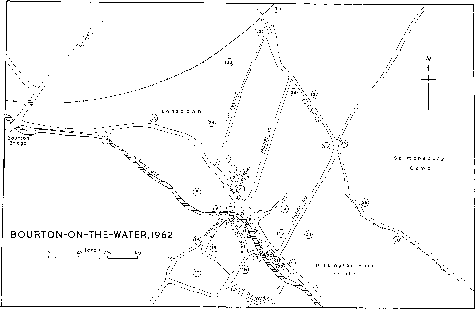
Bourton-on-the-Water in 1962
KEY TO MAP OF BOURTON-ON-THE-WATER
1. Parish church
2. Old Rectory
3. Rectory
4. Church Room, former
National school
5. Manor-house
6. Lower Mill
7. Big Bridge
8. Narrow Bridge
9. Payne's Bridge
10. The Green
11. Victoria Hall
12. Old Baptist Manse
13. Baptist church
14. The Manor
15. Sherborne Terrace
16. Harrington House
17. Grey Gables
18. Chardwar House
19. Christadelphian chapel
20. Police station
21. Post office
22. Bank
23. New Inn
24. Eastfields, formerly the cottage hospital
25. The Red House, formerly
the cottage hospital
26. Cottage Hospital
27. Salmonsbury Cottages
28. Camp House
29. Graveyard, with site of old
Baptist chapel
30. Burghfields
31. Railway station
32. Railway Inn
33. Secondary school
34. Primary school
35. Former Zion chapel and
British school
36. Mill House, formerly Upper
or Bourton Mill
By the 11th century the church was established on its site at the north-west end of the post-medieval village; (fn. 24) this, and the discovery of pottery of the Norman period near the centre of the village, (fn. 25) indicate that by the 12th century the village had at least begun to assume its orientation along the course of the Windrush. It is possible that the building of houses there was connected with the diversion of the course of the river, mentioned above, and that previously the village street had run between the church and Salmonsbury Camp. Several 'cot-acres' mentioned in 1620 as lying in the field north of the village (fn. 26) may derive from the cotlands of the 12th century, (fn. 27) which were presumably associated with dwellings. The villager surnamed Burimon in 1327 (fn. 28) may have been so called because he lived near the camp, rather than in the main village, and indeed the name of the village itself might be taken to indicate a closer geographical relationship (fn. 29) between the village and the camp. Camp House and Burghfields, both built before the parliamentary inclosure of 1774, may be on sites that have been continuously occupied since before the village was built beside the river, but it is also possible that they owe their location to the inclosure of most of the Bury field in 1620. (fn. 30) That inclosure could account for the disappearance of any positive trace of a village street between the church and the camp, though the apparently ancient track from the camp to Rissington Bridge remained in use.
By the late 17th century the village stretched along the north-east side of the Windrush from the church to the road leading towards the camp (later called Station Road), and on the south-west side formed a rough square round Sherborne Street and Threadneedle Street (later called Victoria Street). (fn. 31) The main bridge over the stream was Big Bridge, by the mill, then called the Broad Bridge, (fn. 32) and there was presumably another bridge a little way downstream. There, roughly at the middle of the High Street, was the focal point of the village, where the street crossed a wide green, on which were the village stocks. (fn. 33)
At that time the green is unlikely to have extended nearly so far along the river, either towards the manor-house, church, and rectory at the north-west end of the village or south-eastwards, where what later became green was a copse or shrubbery until the early 19th century. (fn. 34) By 1773 the two parts of the village were connected by four bridges: (fn. 35) the one opposite the green (Narrow Bridge) had been built in 1756, and the one further downstream (Payne's Bridge) was rebuilt in 1776. (fn. 36) All the bridges, including the later ones, have three arches, are slightly humped, and have very low parapets. By the end of the century Bourton was clearly regarded as a village of attractive appearance, (fn. 37) though it was said that the prospect was much too regular to be very picturesque. (fn. 38) The stocks were removed from the green c. 1860; this may have been part of an attempt to improve the appearance of the centre of the village, which had been described in 1856 as 'genteel and pretty.' (fn. 39) George Frederick Moore in 1911 built the road-bridge that leads from High Street to Victoria Street, which for a time replaced Big Bridge as the main crossing, (fn. 40) and he was to a great extent responsible for planting new trees and reducing the grass to order. Opposite the village war memorial he had a field-gun placed; it was set in concrete to prevent a repetition of its being dragged into the river by a party of unsympathetic villagers, but after Moore's death in 1927 it was removed by general consent. (fn. 41) By gift in 1924 and by his will Moore set up a trust fund yielding £36 a year for the maintenance of the green. (fn. 42) Since Moore's time the main change in the appearance of the green has been the alteration of many of the house-fronts for commercial purposes. In 1961 a ditch running along the green was filled. (fn. 43)
The growth of Bourton in size and prosperity from the mid-17th century was perhaps stimulated by agricultural changes in the parish, (fn. 44) and is reflected in the size and architectural richness of the houses. In the 17th and 18th centuries the south-west side of the village probably provided most of the new building sites, both for cottages and larger houses, and that part of the village increased both in area and density; the High Street also was extended slightly at each end. In the early 19th century the north-westward extension of the High Street was carried much further, creating the area known as Lansdown, in which building continued steadily into the mid-20th century. In the late 19th century an important development was the beginning of a completely new road (later Moore Road) from the middle of the village towards the railway station, where a small settlement had grown. (fn. 45) In the 1930's a group of houses called Salmonsbury Cottages was built by the rural district council north-west of the village, and another estate was later built beside the station by the council. After the Second World War many houses were built, by the council and by private developers, along the road leading south-east from the village towards Rissington Bridge. These houses engulfed the small hamlet of Nethercote, which existed in some form in the 12th century, (fn. 46) contained a large house and more than one family in the early 14th century, (fn. 47) and had one large house, two small ones, and an inn in 1773. (fn. 48) In 1962 further houses were being built beyond Nethercote, and also on the south-west side of the village. The isolated houses in the parish, with the exception of Camp House and Burghfields (mentioned above) were all built after the parliamentary inclosure of 1774. In the late 18th century and early 19th nine outlying farm-houses were built, some with adjoining cottages. Other houses built remote from the village before the 20th century included Whiteshoots and the 'Coach and Horses', both on the Foss Way, and some houses near the station. (fn. 49)
The population of Bourton evidently increased during the 14th century: whereas in 1327 both the number of taxpayers and the amount of tax assessed for Bourton were near the average for the hundred, (fn. 50) in 1381 only Stow-on-the-Wold and Sherborne surpassed Bourton's figure of 118 poll-tax payers. (fn. 51) In the mid-16th century, however, the number of communicants was lower (fn. 52) than the number of polltax payers in 1381, and the population remained static until the mid-17th century, when the number of households rose from c. 40 (fn. 53) to 70. (fn. 54) In the 18th century the population rose from an estimated 350 (fn. 55) to 615 three years before inclosure (fn. 56) and c. 700 in the early 19th century. (fn. 57) By 1851, despite emigration to America in the thirties, (fn. 58) the total had risen to 1,040 and then remained steady until 1931, when it was 1,100. Between 1931 and 1951, with the building of new houses, the population increased by over half (fn. 59) and it continued to rise thereafter.
The growth of Bourton is attributable in part to its good communications with its neighbours, which have given it easy access without making it a market centre. One reason why it did not have a market in the Middle Ages was that it belonged to Evesham Abbey, (fn. 60) which owned a market at Stow-on-theWold: (fn. 61) Stow was better served by roads and was more nearly central in the abbey's group of estates in the area. Nevertheless, as suggested above, (fn. 62) prehistoric settlement in Bourton may be associated with an Iron Age trackway, the continuation of which is perhaps marked by the road leading west from the village towards Andoversford and Gloucester, and the Romano-British settlement was connected with the crossing of the Windrush by the Foss Way. There was a bridge there in the Roman period, (fn. 63) a ford in the 8th century, (fn. 64) and by 1483 a stone bridge. (fn. 65) Up to the early 16th century, however, the recognized route from Bourton to Northleach was not by the Foss Way but through Farmington. (fn. 66) Bourton Bridge, which had previously been wide enough for one team at a time, was rebuilt as a county bridge c. 1805; (fn. 67) it was again widened and rebuilt in 1960. The Foss Way was a turnpike from 1755 to 1877. (fn. 68) The road leading south-east out of the village had evidently been built up above the level of the surrounding marshy land by 1539, when it had given its name to Causeway mead. (fn. 69) By 1536 this road was carried over the River Dikler by Rissington Bridge; (fn. 70) in 1955 (fn. 71) a new bridge was built alongside the narrow 18th-century bridge, which survived in 1962, and the line of the approach road from Bourton was altered. From 1862 to 1962 Bourton was served by a railway, with a station only half a mile away, an unusual advantage for a Cotswold village. Until 1881, when the railway line was extended to Cheltenham, Bourton station was the terminus of a branch line from Kingham (Oxon.). (fn. 72)
The buildings of Bourton-on-the-Water are of the 17th century and later, except for part of the church and two or three houses which incorporate 16thcentury work. Presumably there were few stone houses before the 17th century: a lease of Nethercote manor in 1532 mentions timber but no stone for the repair of the buildings. (fn. 73) The manor-house was rebuilt in stone apparently in the 16th century; when the rectory was rebuilt c. 1580 (fn. 74) it may have been of stone, but it was rebuilt 40 years later (fn. 75) and no part of the 16th-century building can be identified; two smaller houses, the smithy cottage and the cottage adjoining Vine House, originated as stone buildings in the late 16th century. By the early 17th century timber was not plentiful in the parish, (fn. 76) and this may have encouraged building in stone. Stone-pits were mentioned in 1584, (fn. 77) and by 1692 the quarries in the parish were extensive. (fn. 78) Presumably these quarries had provided all the stone used up to the late 17th century, but it is questionable whether they also provided the freestone that is such a feature of the larger 18th-century houses in the village. In the early 19th century the quarries were larger (fn. 79) than the remains of them visible a hundred years later, and it is possible that the supply of freestone was exhausted. Until the mid-19th century nearly all the houses were built of stone, with Cotswold stone roofs: the roofs of Welsh slate, clay tiles, or other materials on a few of the older buildings are mostly later changes. Even after the mid-19th century, builders usually imitated as closely as they could the traditional building materials: nearly all the houses built after c. 1930 are of stone or reconstituted stone.
The 17th-century houses in the village show a profusion of the characteristic features of Cotswold architecture: projecting gables, string-courses, windows with stone mullions and dripmoulds, and stone hoodmoulds over the doors, features that were strikingly represented in the 17th-century parsonage house, which boasted 140 separate lights (having mullioned and transomed windows). (fn. 80) This architectural richness and the comparatively large number of substantial 17th-century houses may be seen as an indication of the prosperity of the village at the period, but this view should not overlook the fact that many of the smaller houses were embellished, and nearly all the larger ones were given their greater size, often by skilfully imitative additions, in or after the late 19th century, when the village was exerting its charms as a picturesque rural retreat. The addition to Sherborne Terrace, the original part of which bears the date 1650, is inscribed 1914, when the rest of the terrace was largely rebuilt, and the additions to Chardwar House are easy enough to detect; it is not easy to see that Dial House, dated 1698, and Grey Gables were given a considerable part of their apparently 17th-century fabric during the 20th century. (fn. 81)
Even the larger houses were built of rubble in the 17th century; in the 18th most of the larger houses were built of ashlar and used several imported features. Harrington House, described below, is the most notable example. Among the houses with hipped roofs is the Mill House of the Upper Mill; and the New Inn (which has a sundial dated 1712), Hartley House, and Windrush House have half-hipped gables masked by truncated parapets, apparently a local feature. The Old Manse, the size of which indicates the prosperity of the Baptist community, is, however, of rubble and has mullioned instead of sash windows on the elevation away from the street; it was built in 1748. (fn. 82) The Old Rectory, though built c. 1820, belongs with the 18th-century houses of the village; the larger houses of later date, and the farm-houses of c. 1800, though they often have sash windows with architraves, hark back to an earlier tradition.
The manor-house (to be distinguished from the 18th-century house that was called the Manor from c. 1900) (fn. 83) may be on the site where a residence for the abbots of Evesham was built c. 1200. (fn. 84) John Lane, who farmed the manor from 1514, (fn. 85) and his son William lived in a house known in the 16th century as the bridge end house; (fn. 86) this was evidently the manor-house, which was the last house in the village at the end towards Bourton Bridge. In the mid-19th century the manor-house was largely demolished, and only a small part of the south front, apparently built in the late 16th century, remained standing. What was left was used as a dispensary until 1890 when Dawber rebuilt the house for Dr. F. R. S. Corser. In 1919 the house was again rebuilt, supposedly in the style of the 16th-century house. (fn. 87) In the garden a large round pigeon-house survived in 1962.
Nethercote Manor stands on a site half a mile south-east of the village centre where apparently there was a house in 1532, (fn. 88) and perhaps where the hall of Nethercote stood in the early 14th century. (fn. 89) Thomas Collett built a new house there in 1689, (fn. 90) shortly after buying the manor. This house has been altered less in the 19th and 20th centuries than any of the other larger 17th-century houses in Bourton, although there is an addition on the south-east side dated 1949. The house is of rubble, and the windows have stone mullions and dripmoulds. The northwest front, of three stories with three gables carrying ball finials, has two doorways, of which the southern one has a low arch with imposts and keystone. The range of farm-buildings east of the house are also of the late 17th century.
Harrington House, the most imposing of the houses in the village, was built c. 1740, incorporating as its northern wing a 17th-century house which had been rebuilt c. 1700 by Anthony Collett (d. 1719), whose niece and eventual heir Elizabeth married William Moore (d. 1768), a lawyer. Moore built the house, of yellowish ashlar, in a regional Palladian style. The house is of two stories, with the cornice and pediment carried by pilasters. The Cotswold stone roof is surmounted by a domed gazebo and surrounded by a balustraded parapet with vase finials. The windows, with segmental heads, have moulded architraves and keystones, and the doorway has rusticated Ionic pilasters supporting a cornice and pediment. The gate-posts in front of the house are of vermiculated stone with ball finials. The interior, with unusually elaborate rococo plaster-work, is of c. 1740, and the contemporary staircase is lit by a Venetian window in the centre of the garden front. In 1776 William Moore's second wife, another Elizabeth, married Sir James Harrington, Bt. (d. 1782), after whom the house is called, and after her death the house passed to an illegitimate son of William Moore. Early in the 19th century it was bought by a Mr. Hall, and by c. 1860 was owned by a Mr. Mills who used part of the house as a brewery. Alfred Hadley, who continued to use it in the same way, bought it c. 1870, and his family lived there until 1922 when it was bought by J. A. Fort, who added a southern wing in the same year. (fn. 91) From 1947 the house was used as a Holiday Fellowship hotel. (fn. 92)
A house on the site occupied by Burghfields, a short way out of the village, was bought in 1703 by John Jordan. (fn. 93) Another John Jordan (known as Squire Jordan) rebuilt the house in the late 18th century. (fn. 94) It is of rubble with a hipped Cotswold stone roof with a modillion eaves cornice; it has two stories with sash windows with keystones, and dormered attics.
An ale-house was recorded in Bourton in the mid-16th century, when the Rector of Wick Rissington was accused of spending all his time there. (fn. 95) Victuallers were recorded in 1639 (fn. 96) and 1755, (fn. 97) although in the late 17th century it was said that Bourton had no ale-house. (fn. 98) The New Inn is likely to have been built as an inn in the early 18th century, and by 1773 there was also the Fox Inn at Nethercote, in the angle formed by the lane and the main road. (fn. 99) By 1824 the 'Coach and Horses' existed on the Foss Way, north of the village, (fn. 100) and in 1856 there were four inns in the parish: the New Inn, the 'Coach and Horses', the 'Woodman', and the 'Wellington'. By 1864 the 'Woodman' had been replaced by the Railway Inn. The Lansdown Inn (later rebuilt and renamed the 'Mouse Trap') was built c. 1890, and with the addition of the 'Bell' the number of inns was six in 1939. (fn. 101)
The Bourton-on-the-Water Village Hospital (later usually called the Moore Cottage Hospital) was opened, the third of its kind in the country, in 1861, largely through the efforts of John Moore, a local surgeon. The yearly number of in-patients was c. 30, of out-patients c. 170. The original building (later the house known as Eastfields) was rented, (fn. 102) and in 1879 the hospital was moved to a new building (later the Red House) on a site given by W. S. Stenson. (fn. 103) In 1928 the hospital was moved to another building, provided by George Frederick Moore. (fn. 104) Under the National Health Act of 1946 the hospital, which had formerly been maintained largely by voluntary contributions, passed under the management of the Banbury and District Hospital Management Committee. (fn. 105)
The Victoria Hall was built by subscription in 1897 to commemorate the queen's jubilee, and was intended to provide a reading room and space for meetings and entertainments. In 1924 George Frederick Moore gave the trustees a cottage, the sale of which provided an endowment fund of over £1,000 for the hall. (fn. 106) By the fifties the hall was being used as a working men's club, (fn. 107) and in 1962 it became the home also of the local Y.M.C.A., (fn. 108) which had formerly had rooms in Lansdown. In Lansdown also was a British Legion Branch, and near the church was the Bourton Vale Community Centre, opened during the Second World War. (fn. 109) The village had a long tradition of local clubs. In 1803 there were two friendly societies, and in the next ten years membership of friendly societies rose from 247 to nearly 400. (fn. 110) New friendly societies were registered in 1828, (fn. 111) 1837, and 1838, (fn. 112) and a club day, for various societies, with a dinner at the New Inn, continued to be held until c. 1930. (fn. 113) Club Day, the first Friday in June, survived in 1962 as a pleasure fair in the village street. Another pleasure fair was held on the first Friday in May. The Bourton Vale Cricket Club, founded in 1883, is the oldest of the village sports clubs, which include football, hockey, and tennis clubs. (fn. 114) The sports ground on the Rissington road was enlarged c. 1952; one contribution towards the cost of the new ground came from the proceeds of the sale of the town quarry, allotted under the inclosure Act of 1773 and by then worked out. (fn. 115)
The village was supplied with water by a large number of wells (some 200 in 1930, but only ten of them more than seven feet deep) (fn. 116) until 1936 when main water was brought by the North Cotswold R.D.C. A sewerage system had been built early in the 20th century. (fn. 117) In 1869 the village streets were lit by oil-lamps, the expense being met in part out of the proceeds from penny readings and concerts. In 1882 a gas company was formed: plant was installed near Clapton Row, and the gas used for the street lamps. By 1916 the streets were lit by electric light, the power being supplied by the Bourton-onthe-Water Electric Light and Power Co. which was founded in 1912, (fn. 118) was empowered to supply the area of the parish only, (fn. 119) and by 1942 had been merged with the Wessex Electricity Co. (fn. 120)
The village figured briefly in England's political history in 1644 when Charles I and the Prince of Wales lodged one night there on the retreat from Oxford. (fn. 121) In 1667 Dr. Richard Gardiner, Canon of Christ Church, Oxford, and a noted preacher, gave an estate at Bourton which he had bought in 1662 to his college for the support of two servitors; the college retained the estate until the early 20th century. (fn. 122) John Collett Ryland (1723–92), the divine, was born at Bourton and sent to school by Benjamin Beddome, (fn. 123) the Baptist minister. (fn. 124) Edwin Ransford (1805–76), the actor, was born at Bourton and buried there. (fn. 125)
It is not, however, for its historical associations that Bourton-on-the-Water is widely known. The easy course of the River Windrush under arched stone bridges and beside grassy banks set around with the old stone houses of the village has long given Bourton a distinction among its neighbours, and certainly by the later 19th century retired people of the professional classes were being drawn to settle in the village. (fn. 126) Bourton, with its railway station, was affected as much as anywhere by the growing appreciation of the Cotswolds, and the increased use of motor transport after the First World War brought a considerable holiday traffic to the village, with a resultant growth in the numbers of guest-houses and tea-shops. (fn. 127) After the Second World War there was a change both in the scale of the local tourist industry and in the type of attraction offered to the visitor. The first indication of this change was the opening in 1937 of the 'model village' (a miniature replica of the centre of Bourton) in the grounds of the New Inn, thereafter called the Old New Inn. (fn. 128) Later enterprises, which do not have the same logic behind their location in the village, include an aquarium, an aviary, a vivarium, and a 'witchcraft museum'. The number of tea-shops, snack-bars, souvenir-shops, and filling-stations has increased correspondingly.
Manors.
The manor of BOURTON was among those which Evesham Abbey claimed to have been granted in the early 8th century by Coenred. (fn. 129) In the years 779 and 949, however, the estate was the subject of royal grants to laymen (to Offa's thegn Duddo in 779 and to Edred's miles Wulfric in 949), (fn. 130) and it may be that what the abbey later regarded as the redemption of the estate in the early 11th century (fn. 131) in fact represents the abbey's original acquisition of Bourton. (fn. 132) From the Anglo-Saxon period the estate evidently included the neighbouring parish of Clapton, (fn. 133) which is not mentioned in Domesday. In the 12th century Evesham Abbey clearly held the whole of Clapton, which was then closely connected with Bourton manor (fn. 134) and was in 1535 regarded as part of that manor. (fn. 135) It was only with the dispersal of the monastic estates that Clapton was separated from Bourton manor. (fn. 136)
Nearly all the parish of Bourton, as well as Clapton, was within the manor belonging to the abbey, which received grants of various estates in fee in Bourton in the 12th, 14th, and 15th centuries. (fn. 137) The manor, rated as ten hides in 1086, (fn. 138) was held as one knight's fee with Broadwell. (fn. 139) The profits from the manor belonged to the abbey's chamber until the late 12th century, when the abbot appropriated them, and c. 1200 the monks ceded Bourton to the abbot, getting Adlestrop in exchange. (fn. 140) The abbot was granted free warren in his demesne lands of Bourton in 1251. (fn. 141)
The reversion of the manor, which with the abbey's share of the tithes (fn. 142) had been let before the Dissolution, (fn. 143) was granted by the Crown in 1562 to Edmund Brydges, Lord Chandos (fn. 144) (d. 1573), whose grandson, Gray, Lord Chandos (d. 1621), (fn. 145) sold the manor in 1610 to Sir Thomas Edmunds, (fn. 146) later Treasurer of the Household. Sir Thomas, who died at Bourton in 1639, settled the manor in 1635 on his daughter and coheir, Isabella, who had married Henry West, Lord de la Warr (d. 1628); her grandson John, Lord de la Warr (d. 1723), sold it, apparently after 1687, to Charles Trinder, whose family had owned land in Bourton in 1648. (fn. 147) Trinder is said to have been a descendant of Sir Thomas Edmunds, (fn. 148) and in 1671 he occupied the largest house in Bourton. (fn. 149)
By 1721 the manor had passed to John Wright and Charles Bodenham, (fn. 150) who were related to Trinder and may have been trustees, (fn. 151) and in 1729 they conveyed the manor to Thomas Church. (fn. 152) In 1735 and 1738 the lord of the manor was a Mr. Partridge and in 1743 Samuel Ingram of Coln St. Aldwyn, (fn. 153) who was succeeded c. 1777 by his brother Thomas Ingram (d. 1806) and his daughter Frances, who married John Rice of Bourton-on-the-Water. Frances died a widow in 1834, having settled the estate on a distant cousin named in her uncle's will, Bowyer Vaux, a Birmingham surgeon. (fn. 154) Soon afterwards the estate was sold off in small lots. (fn. 155) By 1885 part of the manor belonged to William Snooke Stenson, who was one of the main landowners; his widow, regarded as sole lady of the manor, called her house the Manor. This house, and the titular lordship, passed c. 1920 to Roger Pilkington Young, whose widow, though she did not live in the village and no longer owned the house, was titular lady of the manor in 1962. (fn. 156)
In the 12th century Robert of Nethercote held of Evesham Abbey one hide in Bourton, for which he made suit of the county for the township, and a messuage and two and a half yardlands for which he paid rent. (fn. 157) This Robert is presumably the same as the Robert of Slaughter who held five yardlands in Bourton (fn. 158) and in 1192 successfully resisted the claim of Osbert Scot to five yardlands specifically stated to be in Nethercote. (fn. 159) A Robert of Nethercote witnessed a charter of 1209, and granted land in Sherborne to Winchcombe Abbey, (fn. 160) and a man of the same name was one of Evesham Abbey's knights in 1237. (fn. 161) In the early 14th century people of the same surname were substantial landowners in Bourton, and may have held the sub-manor of NETHERCOTE: Sir Simon of Nethercote occurs in 1269 and c. 1300, William of Nethercote in 1312, Robert of Nethercote in 1311 and 1327, and Robert's son William in 1333. (fn. 162)
Nethercote does not reappear in the records (fn. 163) until the early 15th century. In 1412 John Browning, lord of the Leigh, made a settlement of land in Nethercote and the neighbourhood, (fn. 164) and in the middle of the century William Browning claimed that his farmer had been violently ejected from Nethercote manor. (fn. 165) In 1484 Alexander Browning conveyed the manor to Robert Tailor of Bourton, in the hundred court of Slaughter, (fn. 166) and in 1486 this conveyance was confirmed by a suit in the king's court, to which it had been remitted by the Abbot of Evesham. (fn. 167)
By 1532 the manor, containing over 100 a. of arable and meadow, was held by Henry Tailor of Bourton, who then received it at farm from Evesham Abbey, apparently in return for his surrendering the freehold, (fn. 168) and whose widow was granted a lifetenure of the manor the same year. (fn. 169) In 1547 Nethercote manor was granted to Lord Seymour along with Stow-on-the-Wold, (fn. 170) with which it passed in 1550 to Henry Willoughby. (fn. 171) In 1567 Thomas Willoughby, who in 1580 sold his estate in Stow, made a settlement of the manor, and in 1590 was succeeded by his son Robert who died in 1595. Robert's daughter and heir Eleanor (fn. 172) married, in or before 1612, Thomas Berington, (fn. 173) who in 1617 sold Nethercote manor to Sir Thomas Edmunds, (fn. 174) lord of Bourton manor. It passed with Bourton manor until the late 17th century when it was sold to Thomas Collett, (fn. 175) who in 1689 built the house at Nethercote that bears his initials. Another Thomas Collett was succeeded, in or before 1759, by his son William, who in 1765 sold Nethercote to William Palmer. Palmer died in 1807 or 1808, and his son Samuel soon afterwards went bankrupt. (fn. 176) In the late 19th century part of the estate and the former manor-house belonged to William Snooke Stenson, who also owned Bourton manor. His son sold the Nethercote estate to Mr. E. H. Cook, the owner in 1962. (fn. 177)
Economic History.
In 1086 Bourton-onthe-Water, together with Clapton, supported 13½ ploughs on land assessed as 10 hides, and the value of the estate had risen by half since 1066. (fn. 178) This expansion continued, for about a century later Bourton alone contained 10 plough-lands and 3½ yardlands. Another half yardland, making up the number of plough-lands to 11, may have comprised the four parcels each of 4 acres held by tenants, (fn. 179) and this calculation in turn suggests a yardland reckoned as 32 acres.
The demesne, which supported six ploughs in 1086, (fn. 180) amounted to four plough-lands in the 12th century, (fn. 181) at the end of which one plough-land was alienated. (fn. 182) Thereafter the demesne remained constant: 3 plough-lands in 1291, (fn. 183) 12 yardiands in 1620 when it was consolidated and inclosed. (fn. 184) From the early 16th century, and presumably for a century or more before, the demesne was let at farm. (fn. 185)
In the tenants' land there was no such continuity. The number of tenants' yardiands doubled between the late 12th century and the early 16th, and this is likely to have resulted from the division of yardlands more than from the breaking of new ground. The free tenants, two in 1086, (fn. 186) numbered nine in the late 12th century holding from six and a half yardiands to a single cottage. (fn. 187) The grants of estates in fee to the abbey (fn. 188) increased the customary land and reduced the number of free tenants, and there were only three in the early 16th century. (fn. 189) The other tenants in 1086 comprised 16 villani and eight bordars; (fn. 190) in the 12th century there were 17 unfree tenants holding varying amounts of land who all owed money-rents and aid but of whom only two owed labour-services (one of them was the smith who held a yardland for making or maintaining the demesne ploughs), and there were also 14 agricultural labourers owing money-rents and works and nine cottagers owing works only. (fn. 191) Cash sums instead of works were being paid in 1291. (fn. 192)
By the early 16th century there were 19 copyholders in Bourton holding about half the land of the parish in lots of from half a yardland to five. A few more copyholders held houses only or smaller areas of land. (fn. 193) The copyholds were not heritable, (fn. 194) and in the early 17th century the tenants appear to have co-operated with the lord of the manor in converting the copyholds into leases, mostly for terms of years, a process that was completed after 1620. (fn. 195) Heriots, some in cash and some in kind in the 16th century, (fn. 196) continued to be payable on some if not all leases. (fn. 197) The larger leaseholds were in turn mostly converted into freeholds in the late 17th century. (fn. 198)
In the early 14th century there were at least two open arable fields. The South field, to judge from the names of places within it, covered a considerable part of the land south of the Windrush, while the North field lay in the northern corner of the parish; besides these two there was also a field called the Bury field, which was also north of the village and may have contained only permanent grass-land. (fn. 199) By the early 16th century all the open land north of the village was regarded as one field called the Bury field or North field, and the southern piece of open arable was called the Town field. The Town field was divided into two, (fn. 200) with the road to Farmington separating what were called West field and South field in the 17th century. (fn. 201) In the Bury field a similar division may have survived from the division between the former Bury field and North field, as is suggested by descriptions of holdings there in the mid-17th century. (fn. 202) This sub-division, however, does not necessarily indicate the use of a four-course rotation, and is more likely to arise from the dissimilarity between the Bury field, which in 1584 contained a high proportion of meadow and ley, (fn. 203) and Town field: the arable land of Nethercote manor in the early 16th century comprised 34 a. in each part of the Town field and only 6½ a. in the Bury field (then called the North field). (fn. 204) Both the Bury field and the Town field were divided into furlongs. (fn. 205)
In the 16th century the land of each estate lay mostly in single ridges, though sometimes up to seven successive ridges were in a single ownership. The ridges were described as acres or lands, (fn. 206) and on the evidence of a statement in 1620 that the pieces of land were acres, half-acres, or roods (fn. 207) it may be inferred that when both acres and lands were mentioned those called acres were thought to approximate to statute acres while those called lands were smaller. The size of the yardland may have been larger for the demesne and the glebe than for most of the copyholds, perhaps because (as suggested above) some of the 16th-century copyhold yardlands represented only fractions of earlier ones: the five yardlands of the glebe appear to have averaged over 20 a. of arable each, the twelve of demesne just under 20 a. In 1620, before inclosure, there were 76 yardlands in all; the arable totalled 1,400 a. (an overall average of 184 a. to the yardland), the common down 256 a., and the meadow and lowland pasture 332 a., the rest of the total acreage being made up of old inclosures, lammas meadow, and roads, waste, and water. (fn. 208)
While the open fields, half of which seem likely to have been fallow at any one time, occupied more than half the total parish area, arable farming was perhaps less dominant in the medieval agricultural economy of Bourton than in many of its neighbours, and this is possibly reflected in the comparatively low value given to the demesne plough-lands in 1291. (fn. 209) Not only were sheep grazed in numbers (fn. 210) that made them more than merely complementary to cereals in a traditional sheep-and-corn husbandry, but Bourton was also provided with meadows of unusual richness and extent, as was noticed by Rudge in the early 19th century. (fn. 211) Bourton's meadow-land was not mentioned in Domesday, but by the 12th century, even though the tenants held a large amount, there was evidently some to spare to help provide for Farmington manor, (fn. 212) and at a later date some of the meadow in Bourton was attached to Eyford manor. (fn. 213) In the early 13th century the Abbot of Evesham leased meadow in Bourton to the Templars of Guiting. (fn. 214) Nearly one-sixth of the land in Nethercote manor in the early 16th century was meadow, and almost as much again was open-field ley that was used as meadow. (fn. 215) One-fifth of Bourton manor demesne (fn. 216) and a quarter of the glebe were meadow. (fn. 217)
A shepherd, holding only a messuage, was among the tenants in the 12th century, (fn. 218) and in 1214 Ralph of Bourton tried to start a large-scale sheep-farm there. (fn. 219) The calling of shepherd had provided the surname of two of the inhabitants by 1381. (fn. 220) Early 16th-century wills specify large numbers of sheep, (fn. 221) and Nethercote manor included a sheep-house, and pasture on the fields and the downs for 300 sheep. (fn. 222) The rectory also included a sheep-house, and what seems to have been Rectory Lane was called Sheep Lane. (fn. 223) Two of the main reasons for the partial inclosure of 1620 were said to be the excessive number of animals pastured on the fields and the effects of damp on sheep feeding in the low-lying undrained open fields. (fn. 224)
The inclosure of 1620 appears to have been set in motion by Sir Thomas Edmunds, who had acquired the manor ten years earlier (fn. 225) and had already made some attempts to improve his property. (fn. 226) The inclosure was agreed to in the manor court in 1618 and the redistribution of land and commons was confirmed by a decree in an apparently collusive suit in Chancery. The decree redistributed for inclosure 953 a. of arable or open-field land and 306 a. of marsh and meadow. Most of the arable land inclosed was in the Bury field, because it was more promising for conversion to meadow or pasture and because it was more in need of drainage than the Town field. One-fifth of the inclosed land was allotted to the demesne of the manor, and allotments were made for 34 other estates of which about half were copyholds which were to be converted to leaseholds under the terms of the decree. Rights of common over all the land to be inclosed were extinguished; common on the 468 a. of open field that were to remain open and under the plough was limited to those holding land there, at the rate of three sheep (and no other animals) for two acres; and on the 256 a. of downland, to be used only as a sheep-pasture, eight sheep were to be grazed throughout the year for each yardland, the yardlands being reckoned as formerly. To compensate the 13 cottagers for their cow-pastures in the former open fields and meadows 26 a. of meadow were set aside for them in which to graze one cow each. Common of pasture in the lammas meadows, which were not inclosed, was rated at two cows for each yardland. (fn. 227)
Some, (fn. 228) and presumably most, of the arable land inclosed was converted to permanent grass-land. In the 18th century some leases encouraged the ploughing up of permanent pasture by a reduction in rent, (fn. 229) but rotational practices stipulated in leases were vague and rudimentary; (fn. 230) it may be supposed that they were so on the surviving open fields. The number of farms had shrunk, and compared with the 34 people holding yardlands or fractions of yardlands in 1620 there were eight farmers, four graziers, and perhaps six farming gentlemen and esquires in 1771. (fn. 231) Although by no means all the holders of land in 1620 were farmers, these figures suggest that the farms grew larger and fewer.
The completion of the process of inclosure came in 1774, under Act of Parliament: 873 a. of openfield arable, downland, and common meadow were affected, and out of this there were three allotments of c. 200 a. (to the lord of the manor, the rector, and Mary Collett, the first two receiving most of their shares to replace tithe), three of c. 50 a., and 19 of ¼20 a. (fn. 232) The long-term result may have been to reduce the number and increase the size of farms further: in 1831 there were 11 farmers, of whom only one did not employ labour. (fn. 233) The number of farms rose slightly in the third quarter of the 19th century, fell in the last quarter, and recovered again by 1939. (fn. 234) In 1962 there were ten farms of between 100 and 400 a. (fn. 235)
Inclosure in 1774 changed the type of farming in that more of the higher land was put under the plough, and was used to produce a large quantity of barley and oats by 1801. (fn. 236) There was presumably a corresponding decline in sheep-farming. Throughout the 19th century the upland farms were mainly arable: the proportion was five-sixths on Bourton Hill farm in 1807, (fn. 237) three-quarters on Sweetslade farm in 1900. The valley farms were dairy farms, as perhaps they had mainly been since 1620: in 1858 three-quarters of an estate of 120 a. beside the streams was grass, and nine-tenths of Harp farm in 1898 was permanent pasture. (fn. 238) In the early 20th century the acreage of arable shrank until in the midthirties it included less than half the land above 500 ft. and little below 500 ft. (fn. 239) After much ploughing up in the forties, these proportions of arable and permanent grass-land were roughly restored again by 1962, when most of the farming was dairying, beef, and cereals, with sheep unusually few for the Cotswolds.
There are indications, apart from the size of the village, (fn. 240) that from the 14th century Bourton supported a wide variety of trades and minor industries. The fulling-mill mentioned below (fn. 241) suggests the existence of a local woollen industry by the end of the 12th century, when the inhabitants included two weavers, a cobbler, and a smith. (fn. 242) Wool-workers' trades gave rise to several of the surnames current in 1381. These surnames also show that people living in Bourton in 1381, or their near ancestors, followed the trades of smith, mason, tiler, cooper, fletcher, and lorimer, (fn. 243) and Bourton seems to have served as a centre of rural crafts for the immediate neighbourhood. Bourton retained the character of something more than an agricultural village: in the late 16th century, for example, two butchers from Bourton were frequently trading at Northleach, (fn. 244) and in 1608 the population included four tailors, two smiths, a slater, and a butcher. (fn. 245)
In the 17th and 18th centuries there is little evidence of the woollen industry in Bourton, although mercers and tailors occur and there were two weavers in 1771; in 1856 it was said that the clothing business there had long since declined. The footwear industry, however, established in a small way by the late 17th century, included five cordwainers in 1771, and there was said to be a large number of shoemakers in the early 19th century; there were still at least six in 1889. No reference to masons resident in the village has been found between 1381 and 1771, when there were two, but the evidence of the buildings in the village suggests that all the building trades are likely to have been represented there from the 16th century at least. Carpenters and slaters occur from the early 18th century. Descendants of one of the smiths of 1608 continued in his trade until 1710, apparently at the smithy on the corner of High Street and Moore Road. In 1771 (three years before inclosure) the population included, in addition to those tradesmen already mentioned, two wool-staplers, two mercers, three tailors, a stay-maker, and a mantua-maker; two butchers, four bakers, a maltster, a fruiterer, and a shopkeeper; a collar-maker, two blacksmiths, two wheelwrights, four carpenters, and a millwright; a cutler, a glazier, and two slaters. (fn. 246)
In the early 19th century trades and crafts were a more important source of livelihood than agriculture in Bourton, (fn. 247) but in that period a significant change was the growth in numbers of the shopkeeping, professional, and leisured classes. The professions, in 1771 represented (if at all) by one surgeon, (fn. 248) included in the thirties and forties four surgeons, a physician, and two solicitors, (fn. 249) while the shopkeepers (notably grocers and drapers) had by the middle of the century outgrown any other group of self-employed people. The growing importance of Bourton as a local centre for goods and services continued steadily from the mid-19th century, with the arrival of (for example) a branch bank, an auctioneer, a brewery, a chemist, and a watchmaker, (fn. 250) and with the easier access provided by the railway. (fn. 251)
As elsewhere, agricultural trades declined in importance in the late 19th century, (fn. 252) but in the mid20th century a wheelwright, (fn. 253) a blacksmith, and a saddler were still active, though the blacksmith alone remained in 1962. This decline was balanced and perhaps outweighed by expansion of the building trades; (fn. 254) even more important, economically, has been the growth of the tourist trade, (fn. 255) accompanying the increase in road traffic. The attractions to the tourist have also attracted numbers of people seeking retirement and seclusion, and Bourton has overtaken the earlier centres of Stow-on-the-Wold and Northleach both in population (fn. 256) and in amenities—even apart from those designed to tempt the tourist. Since c. 1930, however, the building of large numbers of houses that were to be occupied by people whose work lay outside Bourton has provided a contrast to the older centripetal forces. A small factory was established during the Second World War, producing aluminium goods; that and garages and agricultural engineering, with commercial and professional work, provided some employment in 1962, but many of the men worked at Little Rissington airfield and many of the women in Cheltenham. (fn. 257)
Mills.
In the 12th century there were three mills on Evesham Abbey's estate. One was kept in hand by the abbot with one yardland, another was held with one yardland by Maud widow of Robert Ainulf for rent alone, and the third was held with one hide by Robert son of Hugh for rent and services. The two tenants' mills were held freely, (fn. 258) and only one mill was listed among the abbey's property in Bourton in 1291. (fn. 259) At the end of the 14th century the reversion of a mill was granted to the abbey, (fn. 260) and in the mid-16th century there were two mills, both held on lease, belonging to the manor. (fn. 261) One was the mill later called Upper Mill, and the other, used as a fulling-mill, was apparently Lower Mill, in the village. (fn. 262) One of the three 12thcentury mills had evidently disappeared; it was presumably in Nethercote, where there was a mill in 1292 and 1326, (fn. 263) and may have been near the confluence of the Windrush and the Dikler, where the name Smiths Mill survived as a field-name. (fn. 264) It is difficult to identify the three 12th-century mills: the fulling-mill with one yardland recorded in 1206 as paying rent to the abbey's infirmary (fn. 265) is likely to have been both Lower Mill and the mill held by the abbot in the 12th-century, but in 1824 Lower Mill was called Hughes Mill (fn. 266) which suggests an identity with another of the 12th-century mills. Lower Mill was not distinguished as a fulling-mill in 1620, and may by then have been converted to corn. Upper Mill was then leased to Walter Kyte, (fn. 267) and in 1777, when it was known as Kyte's Mill, (fn. 268) the miller was Thomas Kyte. By 1858 it was distinct from the rest of the manorial estate, (fn. 269) and Lower Mill was in the same ownership as the manor-house in 1859. (fn. 270) Both mills were in use as corn-mills in 1921, (fn. 271) and Lower Mill was still so used with water power in 1942 (fn. 272) and with electric power in 1962. Upper Mill was converted for use as a private house before the Second World War. (fn. 273)
Local Government.
Draft rolls of the manor court survive for 1573–93, (fn. 274) and a few rolls for 1610–19; (fn. 275) they show the court administering tenures, regulating agriculture, and exercising at least some leet jurisdiction. Courts continued to be held after 1664, (fn. 276) but by the mid-18th century leet jurisdiction had passed to the court held at Stow for the liberty that had belonged to Evesham Abbey: in 1761, for example, the two surveyors of Bourton were presented there for failing to drain the village street adequately. (fn. 277)
There are overseers' accounts for the parish for 1715–59, with lists of parish officers for 1657–1767, and vestry minutes for 1782–1800 and from 1830. (fn. 278) The vestry was run mainly by the richer farmers; only after the beginning of the 19th century did the rector start to play a dominant role in the vestry. (fn. 279) Expenditure on poor-relief rose less in Bourton than in most neighbouring parishes in the late 18th century, and in 1803 the rate was 3s. compared with an average of 4s. 8½d. for the lower division of the hundred. (fn. 280) In the 12 years after 1803, however, expenditure nearly doubled. (fn. 281) This may have resulted from the methods of poor-relief used. From 1783 one of the two overseers appointed was salaried, the other being described as his nominal partner. By 1783 payments were being made to a doctor for the poor, some of whom were sent to the Gloucester Infirmary, and about the same time the vestry began to rent a house for use as a workhouse and introduced the roundsman system. In 1785 a scheme for setting the poor in the house to work was evidently effective, and from 1787 the workhouse was farmed. From 1789 to 1800 the workhouse master also accepted at farm the roundsman's wages, the expenses of the justices, and the sale of coal to the poor, (fn. 282) but by 1803, when 18 families received permanent relief and another 18 people were relieved occasionally, the workhouse had gone out of use, (fn. 283) perhaps because the vestry was trying to drive too hard a bargain.
In 1830 it was decided that parishioners would not be relieved unless they went to church or chapel on Sundays. By this time there seems to have been revived enthusiasm in dealing with poverty, and between 1830 and 1833 financial help was given to 12 families to emigrate to North America. The vestry was conscientious about nuisances and public health in general, an improvement in which was attributed to the liberal help of resident doctors. In 1834 it was resolved that the building then used as a poorhouse should be put in good condition and reopened as a workhouse. (fn. 284)
Under the Poor Law Amendment Act of 1834 Bourton became part of the Stow-on-the-Wold Poor Law Union. (fn. 285) It became part of the Stow-on-the Wold highway district in 1863, (fn. 286) and of the Stow-onthe-Wold Rural Sanitary District under the Local Government Act of 1872 (being transferred to the newly formed North Cotswold Rural District in 1935). (fn. 287) In the mid-20th century the parish council, which in addition to the normal functions administered the graveyard and the Moore village trust, (fn. 288) was meeting once a month. (fn. 289)
Church.
There was a priest in Bourton in 1086, (fn. 290) presumably endowed and presented by Evesham Abbey. In 1209 Bourton was one of the churches for which the abbey claimed exempt jurisdiction; (fn. 291) by that date there was also a chapel at Clapton, which so far as is known has always been dependent on Bourton. Not long afterwards the church of Lower Slaughter was also dependent; it may have originated as a dependent chapel, as it remained until 1954. (fn. 292) Evesham Abbey, which by 1291 was receiving an annual pension of £1 from the church, (fn. 293) was given papal authority for its appropriation in 1345, (fn. 294) but in fact the abbey appropriated only two-thirds of the tithes of corn and hay in Bourton and Clapton, and the benefice remained a rectory. (fn. 295) The appropriated tithes passed with other property of the abbey to the lord of the manor, (fn. 296) but during the 17th century were mainly divided among the owners of the land on which the tithe was payable. (fn. 297)
The patronage of the rectory, exercised until the Dissolution by Evesham Abbey, (fn. 298) was granted in 1579 to Sir Christopher Hatton; (fn. 299) it passed soon afterwards to the lord of the manor, who presented in 1584, 1586, 1589, and 1590. (fn. 300) Presentations were made by John Dutton of Sherborne in 1624, and by Sir Thomas and John Rouse in 1629, (fn. 301) and the advowson passed in the late 17th century to George Vernon, rector 1667–1720, members of whose family continued to present until 1782. (fn. 302) Presentations were made in 1793 by John Ireland, in 1816 by Robert Croome, in 1834 by John Daubeny Croome, and in 1836 by Robert Waller, who presented himself and later granted the advowson to Wadham College, Oxford, (fn. 303) where it remained in 1960. (fn. 304)
The rectory, valued at £13 6s. 8d. in 1291, (fn. 305) remained a rich one even after it had lost some of its tithes, and at £27 2s. 8d. clear was the richest in Stow deanery in 1535. (fn. 306) It was valued at £164 in 1650, (fn. 307) and after inclosure rose to a gross value of over £800 a year in the mid-19th century. (fn. 308) The glebe comprised five yardlands in Bourton and half a yardland in Clapton, (fn. 309) for which 70 a. in all were allotted at inclosure in 1774. The rector's share in the tithes of Bourton and Clapton were mostly exchanged for land amounting to 209 a. in 1774, (fn. 310) and the remainder was commuted in 1847 for a corn-rent assessed at £100. (fn. 311) For the tithes of Lower Slaughter, all of which belonged to Bourton rectory, and for two yardlands of glebe there c. 250 a. were allotted at inclosure in 1731. (fn. 312) Thus in 1845, when uncommuted tithes were paid by composition, the rectory owned 594 a. and received £100 a year for tithes. (fn. 313) The parsonage house was completely rebuilt c. 1580, (fn. 314) in the 1620's, (fn. 315) and in the early 19th century; (fn. 316) in 1960 it was sold, and the stables were converted to provide a house for the rector.
The earliest rector known by name (in the 1230's) was physician to the king, (fn. 317) and several of his successors in the late 13th century and early 14th were pluralists or otherwise non-resident. (fn. 318) In the later 15th century the three known rectors were M.A.'s. (fn. 319) The rector in 1551 was an absentee who, though he had a doctor's degree, was found to be unlearned. (fn. 320) He put the rectory to farm and the farmer paid two curates, one of them to serve Lower Slaughter and Clapton. (fn. 321) His successors included Nicholas Bond, later President of Magdalen College, Oxford, and William Symonds, the divine, (fn. 322) and, in 1625, Robert Wright, bishop successively of Bristol and Lichfield, and first Warden of Wadham College, Oxford. (fn. 323) None of these, however, held the living for long, and Wright was already Bishop of Bristol when instituted to it. (fn. 324) Wright's successor, Dr. Thomas Temple, who was involved in scandalous legal suits with his brother-in-law, his neighbours, and his parish clerk, (fn. 325) and who had another benefice in Oxfordshire, was chaplain to the Prince of Wales. It was with him that Charles I lodged a night in 1644. Temple actively resisted sequestration in 1646, and was restored in 1661. (fn. 326) Anthony Palmer, who held the living during the Interregnum, was a prominent Congregationalist. (fn. 327)
George Vernon, instituted in 1667, was an author and a man of some learning, though a pluralist. He acquired the advowson, and was succeeded in 1720 by his son Richard, (fn. 328) whose neglect of the chapels at Lower Slaughter and Clapton (fn. 329) may indicate his attitude to his office as a whole. William Vernon, a pluralist, was rector 1753–80, (fn. 330) and after little more than a year a fourth member of the family, Edward, whose presentation, it was hinted, was simoniacal, and whose learning, morals, and previous career were attacked, (fn. 331) became rector. Robert Waller, who as patron became rector in 1836, (fn. 332) remained until 1872; W. E. White was rector for almost as long a period, 1901–35. (fn. 333) From 1667 until the Second World War curates for Bourton were licensed at frequent intervals; with few exceptions their function was evidently to serve Lower Slaughter and Clapton, and from the mid-19th century they lived at Lower Slaughter. (fn. 334)
Until the 16th century an additional priest was provided by St. Mary's chantry, founded by Walter of Bourton, Vicar of Yarnton (Oxon.), in 1323 and further endowed by the founder in 1331. (fn. 335) The patronage of the chantry was given to Evesham Abbey. (fn. 336) In 1549 the priest's stipend was 7¼ marks, and the remaining ½ mark of the chantry's income was paid out in rents. (fn. 337) In 1948 the church received an endowment of £1,000 for general purposes under the will of George Frederick Moore (d. 1927). (fn. 338)
The church of ST. LAWRENCE (which in the 19th century was thought by some to be St. Mary's) (fn. 339) is built mainly of ashlar and has a Cotswold stone roof. It comprises chancel and north vestry, nave with north aisle and south porch, and (its most striking feature) west tower. The chancel is mainly of the 14th century, the tower of the 18th, and the rest of the 19th.
The earliest known building was apparently late Saxon, and the nave of that period survived in part (with some later windows) until the late 18th century, with two small round-headed windows high up in the north wall. In the early 12th century a tower was built at the east end of the nave; in 1780 it had a gabled roof. (fn. 340) Traces of a 12th-century chancel arch have been found, but the chancel was extensively rebuilt in the 14th century, with its roof line higher than the nave's and with the sanctuary placed over the vaulted crypt (blocked up in the 19th century) that may be the earliest part of the building. (fn. 341) A south transeptal aisle was built apparently in the early 14th century, for the chantry mentioned above: the priest said mass in a lady chapel joined (contigua) to the church, (fn. 342) and a stone coffin buried under the aisle is locally reputed to have been the founder's. This aisle became known as the Clapton aisle, (fn. 343) and it may be that the rectors that were unwilling to hold services at Clapton encouraged the inhabitants to regard the aisle as their own.
During the 18th century the aisle was rebuilt, and some work was done on the north wall of the nave. The north and south doors of the nave were blocked, as was the window of the Clapton aisle, and the entrance to the church was through a square-headed opening in the west wall. (fn. 344) By 1783 the church was thought to be very ruinous, (fn. 345) perhaps because of a legacy of £1,500 for rebuilding it from Sarah Yates, (fn. 346) and the vestry accepted a design for a new church from William Marshall, an inhabitant of Bourton. The chancel, included in the original scheme, was not structurally altered because, it is said, the rector, Edward Vernon, discovered that none of his family would succeed him in the living. The west tower, built in 1785, has a rusticated base, Ionic pilasters at the angles, and a parapet with vase finials; the spire that was to have surmounted it was replaced by a lead-covered dome because the foundations were not stable enough. On the site of the former nave, aisle, and tower the new nave was built and apparently finished by 1794, with a domed plaster ceiling supported on Ionic columns; it had a west gallery and a colonnaded three-decker pulpit, and opened on the chancel, which was also pewed, by a wide roundheaded plaster arch. (fn. 347) A clock with a chiming barrel was placed in the tower, and its face, dated 1786, survived the installation, at a higher level, of a new clock in 1911; the new clock has the Westminster chimes and a seven-tune carillon. (fn. 348)
Between 1873 and 1878 the chancel was restored, retaining the three-light 14th-century east window, the two-light north and south windows, and a large trefoiled ogee opening for a piscina, the north aisle with the vestry and organ chamber at its east end was added, the chancel arch was rebuilt, and the south aisle was removed. In 1890 the nave was rebuilt with a south porch. All this work was carried out to designs in a 14th-century style by T. G. Jackson. (fn. 349) The windows were filled with stained glass in the late 19th century and early 20th.
The oval-shaped bowl of the 18th-century font, which was replaced during the 19th-century rebuilding and the pedestal of which was lost, (fn. 350) was reset in the 20th century in the west wall of the aisle. A roodscreen was set up in 1924, a reredos in 1928, and the chancel roof was panelled with painted woodwork, all in memory of members of the Moore family. In 1949 a new organ was bought in place of the one that had been bought second-hand in 1880. (fn. 351)
On the chancel wall is a monument to George Vernon (d. 1720), rector, and members of his family. In the mid-16th century the only chalice in the church was that belonging to the chantry, which in 1555 the parish hoped to buy. (fn. 352) In 1708 the parish acquired two chalices, which with a flagon dated 1748 and a paten made in 1890 from two plates also dated 1748, comprised the church plate in the 20th century. (fn. 353) There were five bells c. 1700, (fn. 354) including one of 1650 by James Keene of Woodstock. The other four were replaced or recast by the Rudhall foundry between 1717 and 1785. A blank 19thcentury bell and two added in 1914 brought the number to eight. (fn. 355) The registers begin in 1654, but have gaps for 1712–15 and 1806–12.
Roman Catholicism.
In 1667 Bourton was clearly a known centre of papists, and figures for that year indicate that half the papists in Stow deanery were gathered there. (fn. 356) Charles Trinder, who was living in Bourton in 1671 and later became lord of the manor, (fn. 357) was a papist, (fn. 358) and chaplains are thought to have lived at the manor-house. (fn. 359) In the 19th century rooms on the top floor of the house were traditionally called the priest's room and the chapel, and what was believed to have been a priest's hiding-place was discovered in the same part of the house. (fn. 360) In the 20th century Roman Catholics in Bourton went to the church at Stow until 1940, when services began to be held in private houses in Bourton. From 1942 the church hall of the parish church was used for Roman Catholic services. In 1957 a site was acquired beyond the railway station and in 1960 the temporary stone church of OUR LADY HELP OF CHRISTIANS was opened there. It was served from Stow, and provided for people from the surrounding villages as well as for 26 Roman Catholic families in Bourton. (fn. 361)
Protestant Nonconformity.
Bourton has long had a strong tradition of religious nonconformity, which can be traced as far as the late 16th century when the puritan divine, Richard Stock, was domestic chaplain to the lessee of the manor. (fn. 362) Anthony Palmer, ejected from Bourton rectory in 1661, removed to London, (fn. 363) but another Congregationalist, John Dunce, who may have been Rector of Condicote during the Interregnum, was preaching at Bourton in 1667 and was given a licence for a meeting there in 1672. (fn. 364) Figures for 1676 suggest that Bourton had a higher proportion and a far higher number of Protestant dissenters than anywhere else in Stow deanery. (fn. 365)
The main strength of dissent in Bourton has been with the Baptists. The Baptist community there, said to have been founded in 1650, (fn. 366) was represented by three men at the Baptist meeting of 1655 at Warwick. (fn. 367) In 1660 two Bourton men were preaching as Baptists in Bury field (perhaps exploiting the ramparts of Salmonsbury); one of them was Thomas Collett, (fn. 368) possibly the man who owned Nethercote manor, (fn. 369) was a dissenting preacher in 1715, (fn. 370) and was buried beside the Baptist chapel in 1720, (fn. 371) and whose house was licensed for meetings in 1689. A barn licensed later the same year (fn. 372) may have either replaced it or provided for another group of Baptists. Collett's group were Paedobaptists: (fn. 373) in 1700 they opened a graveyard in Salmonsbury (fn. 374) and in 1701 their newly built chapel was licensed. (fn. 375) The group, however, seems not to have survived separately for very long, and to have been absorbed by another group of Baptists led by Joshua Head (fn. 376) who was preaching in Bourton in 1690 and died in 1719. (fn. 377) The absorption may have taken place after Head's death, when 48 Baptists signed certain articles of agreement, (fn. 378) or perhaps in 1735: the licensing of two houses as meetings in that year (fn. 379) may be the result of re-alignments among the Baptists, and in the same year a diocesan survey recorded that a congregation largely composed of Anabaptists heard sermons on alternate Sundays from an Anabaptist called Flower and a Presbyterian grazier called Collett, (fn. 380) perhaps another owner of Nethercote: the distinction between Anabaptist and Presbyterian may be a mistake for that between Baptist and Paedobaptist. That the Baptist community in Bourton was in some confusion is attested in 1724 by the simultaneous licensing for dissenting worship of the houses of John Collett, Andrew Paxford, and Thomas Kyte, all in Bourton; the denomination is stated for none of them, (fn. 381) but the first two have names with strong Baptist associations.
By 1740, when Benjamin Beddome, the hymnologist, began his 45 years as Baptist minister of Bourton, (fn. 382) the Baptists appear to have been united, meeting in the chapel built in 1701. In 1748 a manse was built, and the chapel was rebuilt. (fn. 383) A new chapel was opened in 1765 on the occasion of the meeting in Bourton of an association of 15 Baptist churches. The numbers of Baptists in the Bourton congregation rose from c. 100 in 1735 to nearly 200 in the 1750's; it included people from many neighbouring parishes, Naunton and Stow-on-the-Wold among them, and the severance of those places under their own ministers accounts for the apparent drop in numbers at Bourton before 1795. (fn. 384) Beddome's death in that year was followed by dissension among the Baptists of Bourton, and it was not until 1801 that they were again united under a single permanent minister. By then the numbers had dropped to 47, (fn. 385) and from this time the community was one of Particular Baptists. In the 1850's the membership was nearly 100, and was said to include a high proportion of the wealthier inhabitants. Congregations of over 400 were claimed. (fn. 386)
The 18th-century chapel, (fn. 387) the site of which was visible in 1962 in the graveyard off Station Road, was replaced in 1876 (fn. 388) by the church, built of stone with a Welsh slate roof, at the High Street end of Station Road. In 1962 the church, which was in membership with the Baptist Union, had branches at Aston Blank and Clapton, and membership totalled over a hundred. (fn. 389)
The old manse was sold in 1928, and a new one built in Moore Road. The proceeds, £653, of the sale in 1950 of land belonging to the chapel was invested in stock, and another £300 was given for the maintenance of the church under the will of C. V. Wilkins (d. 1951). (fn. 390)
Rooms in private houses were registered for worship in 1829, 1831, and 1845 (the last two, apparently, for the same group). A Zion chapel in Lansdown, registered in 1843, (fn. 391) may have been Methodist, but no return for it was made in 1851. (fn. 392) By 1872 it was used as a school, and continued as such until 1902. (fn. 393) The chapel was apparently the building converted into a private house by 1962 and bearing an inscription stone from which all but the date 1842 had been erased. A Primitive Methodist chapel in Clapton Row was built in 1868; in 1904 it became a Christadelphian meeting, (fn. 394) and was still so used in 1962.
Schools.
By will dated 1717 Anthony Collett of Bourton gave a rent-charge of £10 for the teaching of 12 boys of the parish, who were to learn the Church of England catechism. (fn. 395) In 1738 the £10 was paid as a salary to the schoolmaster, (fn. 396) but by 1828 the schoolmaster, who was also the parish clerk, used the money to pay the rent for the school buildings and took additional pupils who paid fees: (fn. 397) the day school numbered 18 in all in 1825, when there was also a Sunday school with 42 pupils. (fn. 398) Other children were presumably taught in dame schools: in 1771 the population included two schoolmistresses besides the schoolmaster. (fn. 399)
In 1849 the Church school acquired its own building on the corner of Rectory Lane, for use as a school in union with the National Society. (fn. 400) A British school was established in 1841 (fn. 401) in a room built on to the old Baptist chapel, (fn. 402) and was moved about ten years later to the former Zion chapel in Lansdown, (fn. 403) and in 1868 had a certificated teacher and nearly 70 children who mostly paid fees of a penny; an extra penny was charged for instruction in writing. (fn. 404) By 1872 attendance had fallen to 38, (fn. 405) and in that year a school board for the parish was formed (fn. 406) and took over the work of both the British school and the National school. The National school building was used for girls and infants, the British school building for boys. (fn. 407) The combined attendance was over 150, and fees of up to 4d. were charged. (fn. 408) Collett's charity was used partly for prizes and partly to support the Sunday school. (fn. 409)
Both buildings were condemned in 1899, and a new school behind the church was opened for all departments in 1902. (fn. 410) In 1958 a county secondary school to serve a wide area was opened, and in 1962 had nearly 300 children. (fn. 411)
There was a boarding school for boys between 1791 and 1799, (fn. 412) and a private girls' school in 1885 and (at Camp House) in the early 20th century. (fn. 413)
Charities.
Besides the £10 a year for schooling, charitable donations in 1815 were said to amount to £10 a year. (fn. 414) This probably referred to the poor's plot, since Jane Farran's gift of a £10 rent-charge for apprenticing, under her will dated 1779, never became effective, and Dorothy Vernon's gift remained inoperative until after 1828. (fn. 415) The poor's plot was 12 a. allotted at inclosure in 1774 to grow fuel for the poor, (fn. 416) but in the late 18th century the land was let and the rent distributed by the vestry. (fn. 417) The Heythrop Hunt rented the land for £18 as fox covert until 1873, when the vestry decided to convert the land to allotments. The allotments were let to poor men at low rents, and in 1890 the rent of £5 9s. was distributed in coal. Under a Scheme of 1957 the land was sold and interest on the capital realized was distributed in coal: the sum so distributed in 1958 was £8 9s. (fn. 418)
Dorothy Vernon (d. 1764) by her will gave a quarter of her money on mortgage or bond for the poor of Bourton, Lower Slaughter, and Clapton who were members of the Church of England. The charity, inoperative in 1828, (fn. 419) may not have taken effect until 1865 when a Scheme was made by which the money, then c. £70 a year, was distributed in the form of tickets for coal and clothing at half price; Bourton's share of the distribution was threefifths. (fn. 420) In 1962 the income of nearly £40 was distributed (Bourton's share being the same) in the form of tickets presentable at local shops. (fn. 421) John Jordan Ansell by deed of 1835 gave a rent-charge of £8 9s. 4d. for distribution among four needy spinsters who had been domestic servants; (fn. 422) this charity, called Jordan's charity, was so distributed in 1962. (fn. 423) The same donor is also said to have given for bread for the poor, by will dated 1846, a yearly sum of 19 guineas which had been lost by 1912. (fn. 424) George Frederick Moore (d. 1927) gave £1,000 in trust for coal for the poor in 1924, and by his will gave another £1,000 for the same; the second of these gifts took effect in 1948, (fn. 425) and £80 a year from the two gifts was distributed in coal in 1961. (fn. 426)