A History of the County of Hertford: Volume 2. Originally published by Victoria County History, London, 1908.
This free content was digitised by double rekeying. All rights reserved.
'The city of St Albans: Introduction', in A History of the County of Hertford: Volume 2, ed. William Page( London, 1908), British History Online https://www.british-history.ac.uk/vch/herts/vol2/pp469-477 [accessed 27 July 2024].
'The city of St Albans: Introduction', in A History of the County of Hertford: Volume 2. Edited by William Page( London, 1908), British History Online, accessed July 27, 2024, https://www.british-history.ac.uk/vch/herts/vol2/pp469-477.
"The city of St Albans: Introduction". A History of the County of Hertford: Volume 2. Ed. William Page(London, 1908), , British History Online. Web. 27 July 2024. https://www.british-history.ac.uk/vch/herts/vol2/pp469-477.
THE CITY OF ST. ALBAN
The city of St. Alban now comprises the whole of the parish of St. Alban, and extends into the parishes of St. Peter, St. Michael, St. Stephen, and Sandridge. The bounds of the borough were first recorded in 1327, (fn. 1) although as early as 1142 its limits appear to have been defined by a ditch, (fn. 2) afterwards called Tonmans Dike, which can still be traced. Crosses were at an early date erected at important points in the line of boundary, and at each of the entrances to the town, namely, the Stone Cross or North Gate Cross (fn. 3) at the north on the Sandridge Road, the Red Cross in Sopwell Lane, at the entrance by the old road from London, the Cross with the Hand in Eywood Lane, the Black Cross, probably at the angle where Tonmans Dike goes from the boundary of the houses in Fishpool Street towards the Claypits, and St. John's Cross at an angle of the boundary in what is now known as Harley Street, but lately as Mud Lane. (fn. 4)
There seems to be no evidence that the town was ever walled. In the time of Abbot Roger de Norton it was secured with bars at the various entrances, (fn. 5) which continued under the name of the barriers or burglays, (fn. 6) and are described in the charter of Edward VI as the Bars in Sopwell Lane, the Bars at Kingsbury Lane, the New Bars on the north—that is, at the Sandridge Road, and the New Bars near the house of Sir Ralph Rowlatt, which stood at the bottom of Holywell Street. The boundaries described in 1327 were again ascertained in 1635, (fn. 7) and continued unchanged as regards the municipal boundary till 1835. In 1832 the bounds of the parliamentary borough were laid down, which included an area east and west outside the old municipal borough, (fn. 8) and these bounds were adopted as the municipal boundary under the Municipal Corporations Act of 1835, (fn. 9) and confirmed under the Municipal Corporations Boundaries Commission of 1837. In 1879 the bounds were enlarged under 'The St. Albans City Extension Act,' (fn. 10) which, except for some land on the north-west of the town belonging to Lord Grimthorpe, fixed the boundary at points radiating from the Town Hall at distances of three-quarters of a mile.
The town appears to have been divided at an early date into four wards. Abbot Richard de Wallingford (1260–1291) appointed four constables of the peace, each with two chief pledges, to take charge of the four parts of the town. (fn. 11) These were named St. Peter's Ward, which corresponded to the part of St. Peter's parish within the borough; the Middle Ward, or roughly the Abbey parish; Holywell Ward, comprising the portion of St. Stephen's parish within the borough and somewhat more; and Fishpool Ward, or approximately so much of St. Michael's parish as was within the borough. Constables were chosen for each ward down to the time of the Municipal Corporations Act of 1835, (fn. 12) when these divisions of the town were abolished.
From an early date St. Albans has owed a great part of what prosperity it has had to the fact that it was the first stage out of London on the way to and from the Midlands, the north-west counties, and on one route to Ireland. In the earlier part of the nineteenth century, before the advent of railways, as many as seventy coaches passed daily through the town. (fn. 13) The Roman road called Watling Street, which originally ran through the Roman city of Verulam, was diverted at an early date, probably about the time of the foundation of St. Albans Abbey, at the end of the eighth century, and carried round the east and north sides of the abbey precincts, by leaving Watling Street at St. Stephen's and going up Holywell Hill, turning down what is now the High Street, George Street, and Fishpool Street, and rejoining the Roman road near the entrance to the Gorhambury Drive at St. Michael's. In the Roman period there was apparently an important road coming from the south-west, passing through the Roman city and on to Sandridge. Another road from London through Shenley, made probably in the eleventh century, (fn. 14) came into St. Albans at Sopwell Lane. This road was diverted in 1562 when Sir Richard Lee built his house at Sopwell, (fn. 15) into what is now called the Old London Road, which remained the principal coach road from London till 1794, (fn. 16) when the existing London Road was made, forming an entirely new entrance into the town in a line with the High Street, thus avoiding the sharp turn at Sopwell Lane and the steep ascent of Holywell Hill. The road through the town connecting it with Watling Street was altered in 1833 when Lord Verulam formed the new carriage drive to Gorhambury and the existing high road was constructed. This new road turned off from the High Street along what is now Verulam Road, joining Watling Street again about a mile out at Bow Bridge. Of the other roads leading into the town, it appears that the Harpenden Road, formerly called Luton Lane, according to old maps, passed along the west side of Bernard's Heath, and not across it as at present. The Hatfield Road was in the sixteenth century called New Lane, and in the following century Cock Lane, while Victoria Street was called Shropshire Lane, and later Sweetbriar Lane. Both these last were until the eighteenth century mere lanes without any houses.
There are three railway stations in the town. The first line that touched the town was the branch from Watford, on the London and North-Western Railway, opened on 5 May, 1858. The Great Northern Railway Company opened their branch from Hatfield to St. Albans on 16 October, 1865, and the Midland Railway commenced to run traffic upon the section of their main line from Bedford to London with a station at St. Albans on 1 October, 1868.
The town evidently originally grew up around the north, east, and west sides of the abbey precincts and extended around the Market Place and along St. Peter's Street, Holywell Street, High Street, and Fishpool Street, all of which existed probably in the eleventh century. The development of the town along these streets, as will be seen from Benjamin Hare's map of 1634, ruled the lines of the old borough boundaries. The most important spot was the Market Place, which originally covered the ground probably from the eastern side of Chequer Street (formerly the Malt Market), to the western side of French Row, and from the High Street to St. Peter's Church. (fn. 17)
At an early date the market was divided into spaces for the booths or stalls of different trades, of which we have mention of the Butchery, Flesh Market or 'Fleshambles,' the Fish Market or Fish Shambles, the Malt Cheping, the Corn Market or Wheat Cheping, the Leather Shambles, the Pudding Shambles, the Wool Market, and Cordwainers or Coblers Row. (fn. 18) As occurred elsewhere, the stalls, which at first were temporary, gradually became permanent and eventually regular houses or shops. In this way the Market Place became largely built over, and the houses and courts and alleys between Chequer Street and the street now called Market Place were gradually formed. French Row, also known as Cobblers Row and Cordwainers Row, was in like manner erected, and was built before 1335, (fn. 19) so that the encroachments on the Market Place must have begun at an early date.
Around the Market Place, which was apparently on the same site as it was at the time of its enlargement by Abbot Walsin in the tenth century, stood the principal buildings. At the south end was the Eleanor Cross, Queen Cross, or Market Cross erected by Edward I to commemorate the resting-place of the body of Queen Eleanor on its journey from Lincolnshire to Westminster in 1290, on the site of which stands a drinking fountain erected by Mrs. Worley in 1874. In the seventeenth century the cross was allowed to get out of repair, and about 1700 the last vestiges of it were carted away to make room for the Market Cross erected in 1703, (fn. 20) an octagonal building with a roof supported upon eight columns above which was the figure of Justice, and within it was the town pump worked by a large wheel. This building was taken down in 1810, but the pump remained for a time. (fn. 21) Close to the site of the Cross stands the Clock Tower, a square building of four stories of flint rubble with stone quoins. From documentary evidence it appears to have been erected between 1403 and 1412. (fn. 22) This building, which will be referred to again later on, contains two bells, the larger of which bears the mark of one of two London founders, William and Robert Burford, who were working at Aldgate between 1371 and 1418. It has an inscription in gothic capitals
MISSI DE CELIS HABEO NOMEN GABRIELIS.
It was rung to call the townspeople together for all purposes, and the curfew, (fn. 23) which had previously been rung from the abbey tower, was, from the time that the existing Clock Tower was built, sounded from it every night at eight o'clock down to about 1861, when some of the inhabitants petitioned that it might cease. The bell was also rung at four o'clock in the morning to awaken the townsfolk to their work, and was to be tolled as a warning when any casualty of fire or fray happened in the town. (fn. 24) The tower contained a clock probably from the time of its erection, but there is definite evidence of the existence of a clock in 1485, when directions were given as to its maintenance and repair. Semaphore signalling apparatus was erected on the top of the tower in 1808 by the Admiralty, and removed in 1814. In the nineteenth century the tower fell into disrepair, and it was decided by the corporation to pull it down. However, a strong expression of public opinion was brought to bear on the town council, and it was repaired by public subscription under the charge of Mr. (afterwards Sir) Gilbert Scott in 1864. (fn. 25)
The ground story of the Clock Tower, now used as a saddler's shop, has open arches on the south and east, and small doorways at the north-east and north-west, leading to newel stairs in the angles of the tower. On these the north-west stair is carried up to the top of the tower, ending in an embattled turret, but the north-east stair ends at the first floor, and connects with the other stair by a passage carried across the north side of the tower, now blocked at its west end. There are fireplaces in the west walls of the first and second floors, and both floors are lighted by cinquefoiled windows on the south and east. The third floor has a like window on the north side only, and the fourth floor, which contains the two bells, has square-headed two-light windows on each face, with modern tracery of quatrefoiled circles over cinquefoiled lights. The old floors are in a great measure preserved, with central bellways. The tower is finished with an embattled parapet and short leaded spire, and though much of its external stonework has been renewed, is a most interesting and picturesque building. (fn. 26)
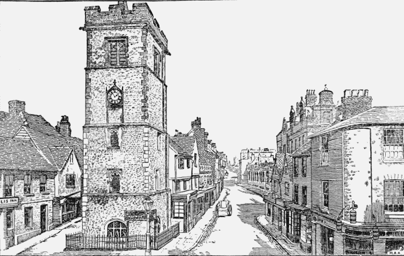
St. Albans: Clock Tower and Market Place
On the east side of the present Market Place stands, detached on all sides, the Corn Exchange, an inartistic building of white brick, which, in 1857, took the place of an ancient open market-house supported on wooden piers. Next to it on the north is a timber building of two stories, now faced towards the street with eighteenth-century brickwork, and having an open arcade below. On the east side are several old houses, one, which is now called the Old Market House, being an early seventeenth-century building of three stories projecting over each other, and preserving two latticed bay windows on the first floor; it stands on a masonry basement with an arched entrance to a cellar. The original ground story front has been replaced by Georgian sash windows, brought forward to the line of the projecting first story.
Opposite to the market-house are two good timber houses of the seventeenth century, their ground stories being used as shops. They have projecting upper stories with bay windows and gables, and on the scrolled wooden bracket at the north-east angle of the northern of the two houses, now in the occupation of Messrs. Boots, chemists, is the date 1637, which is repeated on a modern rain-water head. In the Market Place there was formerly a bull-ring, and here stood the stocks and pillory.
Branching off from the west side of the Market Place is Dagnal Street, formerly also called Bothel Street, which existed as early as 1248. (fn. 27) At the north-east corner of this street, partly facing on the Market Place, is the ancient Moot Hall, now the shop and offices of Messrs. Gibbs & Bramforth, printers and stationers, and proprietors of the Herts Advertiser. The present building is of timber construction with a projecting upper story, showing no details earlier than the eighteenth century. There is a good chimneypiece of this date in the west room on the first floor, which is lighted by a round-headed window, and seems to have been the most important room. There is little to suggest that any part of mediaeval date has been preserved. The Moot Hall is mentioned as early as 1381, when Judge Tresilian sat there to try the abbot's rebellious tenants. (fn. 28) It was the meeting place of the townsmen and gilds, but was the property of the abbots. (fn. 29) At the dissolution of the abbey it was granted to the town under the charter of Edward VI, and continued to be the place of meeting of the town council till the erection of the existing town hall in 1831, when it was sold. (fn. 30) The present town hall is a large building of classical style from designs by Mr. George Smith, (fn. 31) with a stuccoed north front towards St. Peter's Street, of two stories with a projecting central block ornamented with Ionic columns.
There are many ancient and picturesque houses in and around the Market Place. Opposite to the old Moot Hall in the Market Place is a two-story house of which the upper story preserves some seventeenth-century plaster panels of geometrical design and a good cornice with brackets in pairs. At the south end of French Row stood two ancient inns, the 'Fleur de Lys' and the 'Christopher,' parts of which remain as shops with overhanging stories; a portion of the former exposed in pulling down the old 'Great Red Lion,' which formed a part of the original house, showed a fourteenth-century window, the cusped head of which is now preserved in the Hertfordshire County Museum.
The 'Christopher' has its yard entrance on the south, with a gabled story over, and at the north end is a corresponding but wider gable. The central part of the house had a long range of windows on the first floor, now modernized and blocked, and the whole is of timber construction. In the gateway may be seen evidence that the original building, probably of mediaeval date, has been enlarged by adding another range of rooms on the west, and the date of the enlargement may be deduced from the details of a mid-seventeenth-century pilaster with a bracket over carved as a crouching female figure, of the same style as those in the Waxhouse Gate alley.
The 'Fleur de Lys' has been enlarged in much the same way, and in its yard is a little stair with a seventeenth-century balustrade and stair head, probably the only remains of the open gallery which usually ran round the inn courtyards of the time.
At the north end of French Row, and facing what is now the Market Place, are some interesting sixteenth and seventeenth-century houses, and on the east side of the road an old inn known as the 'Boot,' with two plastered timber gables towards the street. In Chequer Street the Queen's Hotel stands on the site of an old inn called the 'Chequers,' (fn. 32) from which the street takes its name. On the site of the present London Road stood the Cross Keys or Peter Keys Inn, the name of which has been perpetuated by the adjoining public-house. It was from behind this inn in Keyfield that the 'men of the Marches' broke through into the Market Place at the first battle of St. Albans in 1455. To this inn it is said that George Tankerfield was brought from Newgate in 1556 to suffer death at the stake at Romeland near by for his religious opinions, and while under confinement at the inn asked for a fire, and pulling up his hose put his leg as near the flame as he could to ascertain how he should endure it on the morrow. The inn was demolished in 1794 to make room for the new London Road.
Down Dagnal Street, on the south side, is the square red-brick Unitarian Chapel in which Dr. Martineau used to preach, an early eighteenth-century building of the plainest description, but interesting as a specimen of an early Dissenting chapel.
A little further on is a turning to the north called College Street, from the Collegium Insanorum of Dr. Cotton, a part of which still stands at the angle of the street. It has an east front facing College Street, with north and south wings, which were once of greater projection, but have been cut back and faced with brickwork. The main building is of wooden construction, and probably dates from the end of the sixteenth century; but the south wall towards Dagnal Street is of flint and stone, the re-used materials of an older building, probably one of the monastic buildings of the abbey destroyed in the sixteenth century. It was here that the poet William Cowper was confined in 1763. Dagnal Street formerly turned into Fishpool Street, by the street now known as Wellclose Street.
The view from the town hall looking northward to St. Peter's Church, with the width of road, the line of trees on each side, and the varying hues of red roofs, is a fine one. There are a number of pretty eighteenth-century brick-fronted houses, with bright red cut-brick window dressings and quoins, and walls of purple stock-bricks. One of the best is close to the town hall on the west, a two-story house occupied by Mr. Edward Simpson, with well-proportioned windows, a deep cornice and red-tiled roof, and a central doorway with a balcony over it, whose wrought-iron railings are a charming piece of early eighteenth-century design. The house contains some fine contemporary plaster ceilings and panelling. Formerly the gardens and lands of the houses in St. Peter's Street extended to the borough boundary, called 'Tonmansdyke,' which on the east side ran along Marlborough Road, and was here also called Houndsditch. The road leading off on the east side was Shropshire Lane, afterwards Sweetbriar Lane, and now Victoria Street, which leads to the Midland Railway Station, and on to the county gaol and Hatfield. A little way down the road, on the north side, is the old Quaker burialground, used from about 1676, and further down on the same side is Marlborough House, the residence of Mr. Samuel Ryder.
At the north corner of St. Peter's Street and Victoria Street stood the Castle Inn, mentioned by Shakespeare (fn. 33) in describing the death of the duke of Somerset at the first battle of St. Albans, who it is said fell in the doorway of the inn.
Richard addressing his dying foe, says:—
So, lie thou there;—
For, underneath an alehouse' paltry sign,
The Castle in Saint Albans, Somerset
Hath made the wizard famous in his death.
Along St. Peter's Street are several good houses, among them Thorne House, the residence of Mr. H. Leslie Bates; the Grange, that of Mr. A. H. Boys; and Donnington House, the residence of Mrs. Scott. The west side is occupied mostly by shops, but at the south end on this side is the interesting early eighteenth-century house already described, now the offices and residence of Mr. Edward Simpson, and further north Aboyne Lodge (Mrs. Betts), a modern brick house with a good garden. The Hatfield Road, formerly called Cock Lane, leads off eastward to Clarence Park (presented to the town by Sir John Blundell Maple in 1894 as a recreation ground), the cemetery (opened in 1885), and on to Hatfield. In this road is the County Museum, erected in 1899 by subscription, on a site presented by Lord Spencer, which contains a good collection of local antiquities and natural history specimens.
Opposite are the Marlborough Almshouses, erected by Sarah Duchess of Marlborough in 1736. They consist of a central block standing east and west with wings at each end projecting northwards. A grass court is thus inclosed between the buildings and the street, and in the middle of it is a fine cedar tree. The buildings are of two stories, in red brick with red-tiled roofs and projecting eaves, the walling being only relieved by a plain band of Portland stone at half height, and a plain stone plinth. In the middle of the main block is a projecting bay with a pediment in which are the arms of Marlborough on a lozenge carried by a double-headed eagle, and flanked by dragons as supporters. The windows and central doorway have stone frames and moulded cornices over them, while all the windows elsewhere are in brick; they have wooden mullions and transoms, and are filled with leaded glazing, which is, however, not original. The interior is plain, the houses being provided with passages running through to the gardens behind. A portrait of the founder is preserved in one of the rooms.

Jenings. Argent a fesse gules with three bezants thereon.
Hatfield Road contains many good houses which were mostly built about the middle and latter part of the nineteenth century. Among them may be mentioned Powys Lea (the Right Hon. Sir Lewis Mitchell), High Croft (Mr. E. W. G. Tappley), Danesfield (Mr. R. L. Howard), and Hawthornden (Mr. Horace Slade). Leading off from Hatfield Road is Marlborough Road, in which is Bricket House, built by the Rev. P. Deedes, now the residence of Lt.-Col. H. F. Barclay. To the north of this road lies St. Peter's Park, a district laid out about 1880 into roads and gradually becoming built over. Here are Hillside (Mr. H. J. Worssam), Ramsey Lodge (The Rev. Canon Hopkins), Beaulieu (Mr. T. F. Ryder), The Moorings (Mr. F. Mead), Clementhorpe (Miss Rokeby Price), and Thirlestane (Dr. Morison).
On the side of St. Peter's Street opposite to the entrance to the Hatfield Road, is Catherine Lane, in which are some old cottages, and in continuation is Folly Lane, where is an eighteenth-century house, the residence of Mr. A. J. Dorell, called Folly House, or Bleak House, which is supposed to be the house from which Charles Dickens named his novel, although the description given by Dickens does not correspond to the present building.
St. Peter's Green, railed in and planted with shrubs in 1898, stands at the widening of St. Peter's Street, just below the church. Here were formerly a duck pond and pump. On the east side of the Green is a row of picturesque seventeenth-century cottages, in the middle of which is a larger red-brick house (with a way through the middle to a yard), which was formerly the parish workhouse, (fn. 34) and is now the offices of Messrs. Rumball & Edwards, estate agents. On the opposite side of St. Peter's Street are a seventeenth-century house, the residence of Col. A. Rumball, and the White House (J. H. Blundell), evidently built at the same time as the Town Hall from the similarity of detail; St. Peter's Vicarage, a long, low building; and Ivy House, the residence of Mr.A. H. Debenham, the town clerk, a large red-brick house, built by Edward Strong, the chief mason employed under Sir Christopher Wren on St. Paul's Cathedral: its best feature is the central doorway, an exceedingly good example with a pediment over.
Immediately north of St. Peter's Church stood until a year or two ago Hall Place, a picturesque old house in which, or its predecessor, Henry VI is said to have slept on the night before the Battle of St. Albans. The site and grounds of the house have now been laid out in roads and are being built over, and nothing remains but the red-brick boundary wall and a pretty wrought-iron gate. Opposite are the Pemberton Almshouses, built of red brick, of a single story, with square-headed mullioned windows of two lights, and six plain round-headed doorways. They are set back a little from the road, with a garden in front bounded by a low red-brick wall, and entered through a tall central gateway, over which is an inscription, dated 1627, recording their foundation by Roger Pemberton, who is buried close by in St. Peter's Church. Tradition says that the iron spike over the gateway represents the shaft of an arrow, and that the founder once shot a widow by accident, and built the almshouses for an atonement. There seems, however, to be no foundation for this story. (fn. 35)
Branching off to Oster Hills at the north end of the Pemberton Almshouses is Grange Street, down which on the north side is a half-timber house, showing little signs of antiquity, which is on the site of St. Peter's Grange or Walmons Fee, an outlying grange of the abbey which was burnt by the rioters at the time of Wat Tyler's Rebellion. To the north of this street the land is being built over. Beyond Grange Street on the west side of the road is St. Peter's House (Mr. A. E. Taylor), and beyond this Boro'gate (Rev. W. Tyrwhitt-Drake).
Before the present London Road was made in 1794 there was no road eastward from St. Peter's Street and Holywell Hill, formerly Holywell Street, (fn. 36) between Victoria Street and Sopwell Lane, then the London Road. Between these points on the steep hill into the town were the principal inns. Of those that now remain the 'Peahen,' which stands at the south corner of the London Road, is, perhaps, the most important. This dates back to the fifteenth century, but the house has recently been entirely rebuilt in a style which cannot be said to harmonize with its surroundings; the only relic of the old inn is some sixteenth-century woodwork in the coffee room. A little below stood the 'Seven Stars,' on the site of Dr. Lipscomb's house. Here, as in many other houses on Holywell Hill, can be traced the old inn yard with its timber archway. Below are the remains of the 'Saracen's Head,' with moulded early sixteenth-century beams in the ceiling of the ground floor, and a four-centred head to its wooden gateway. Adjoining it is the 'White Hart,' a portion of which is still used as a hostelry. At the latter place Hogarth painted the celebrated portrait of Simon Lord Lovat, who was detained here by illness in 1746 on his way to London when committed to the Tower, where he was shortly afterwards executed. The old timber buildings received brick fronts in the eighteenth century, that of the 'White Hart' being an admirable example, with cut brick cornice and pilasters. Behind the brick facing of its gateway there is hidden a seventeenth-century pilaster with a bracket above in the form of a human figure, like that at the back of the old Christopher Inn in French Row.
On the opposite side of the road is a large redbrick house built about 1785 by Sir William Domville, lord mayor of London in 1814, who was created a baronet in that year when he received the allied sovereigns after the battle of Leipzig. The house afterwards passed to Mr. S. Whitbread, M.P., who sold it in 1884 to Mr. E. N. Wix, M.A., who now resides there. It contains some mantelpieces said to be the work of the brothers Adam. Lower down the hill is Ivy House (Mr. J. Earle Norman, LL.D), an interesting old red-brick house, much altered from its original condition, but showing evidence of early seventeenth-century date (parts perhaps belonging to the sixteenth century) and of a good deal of early eighteenth-century refitting. The southern end of the house is an addition to the original building, and a rain-water head on it is dated 1676, though the style of the brickwork, as far as can be seen for the ivy, suggests an eighteenth-century date.
Opposite are The Priory, formerly the Bull Inn, (fn. 37) which Queen Elizabeth visited in 1577, now Mr. Ryder's Seed Stores; Holywell Lodge (Mr. Thomas Kent), and Torrington House (Mr. A. F. Phillips), which last is on a part of the site of Holywell House, the seat of the Rowlatts and afterwards of the Jennings family, demolished in 1827. Sarah duchess of Marlborough was probably born here, and she and the celebrated duke occasionally lived at this house. Miss Ormerod, the entomologist, lived in Torrington House for many years before her death, and here she carried on her investigations as to insect pests. At this point it may be noticed that a side road curves off to the west and meets the main road again a little lower down. This diversion was caused by an extension of the grounds of Holywell House into the roadway. The road, however, was reinstated in its direct course when Holywell House was pulled down. In the field on the east side of the road, now the grammar school playground, was the Holy Well, now covered over, where the ladies to whom Sopwell Nunnery owed its foundation are said to have sopped their bread About the middle of the bend in the road before referred to is the entrance to Lady Spencer's Grove, probably the same as Mary Magdaleyns Grove mentioned in 1549, (fn. 38) an avenue of trees leading to the Abbey Mills.
Southwards of the Market Place lies the High Street with many quaint pargeted houses of the seventeenth century, the best being on the south side, with the date 1665 in its gable. Branching off south to the abbey through an archway, formerly the Waxhouse Gate, is what is now wrongly called the Cloisters, its former name being Schoolhouse Lane. Of the Waxhouse Gate itself part of the base of the walls remains, but the arch which now represents it is a plain round-headed eighteenth-century opening. On the east side of the 'Cloisters' a large shop-front is adorned with a row of seventeenth-century carved brackets like those elsewhere noted, grotesque human figures which were lately removed from the shopfront in the High Street. On the opposite side of the street, in the yard of the Great Red Lion Inn, which was rebuilt in 1896, was formerly an underground stable for ten or twelve horses, used for the coaches running from St. Albans to Watford. Westward of this is George Street, formerly called Church Street, (fn. 39) on the north side, where are the remains of a fine late fifteenth-century house, a two-story timber building with a projecting front, in which one original two-light window remains, and traces of four others are to be seen. Just below it is the George Inn, which dates back to 1446 or earlier. In the fifteenth century this house had its oratory or chapel, where mass was said for the benefit of the guests. (fn. 40) At the corner of George Street and Spicer Street stood the 'Antelope,' previously known as the 'Tabard,' a most picturesque old house dating back probably to the fifteenth century, (fn. 41) which was demolished about 1845.
Beyond George Street is Romeland, formerly a large open space opposite the Abbey Gateway, the middle part of which was in 1812 inclosed and converted into a graveyard. (fn. 42) At one time the fairs were held here, and here in 1556 George Tankerfield, one of the Marian martyrs, was burnt. On the north side of Romeland stands Romeland House, a large redbrick house with excellent masonry details, built by Frederick Vandermeulen, who was elected mayor of the town in 1762, but could not serve on account of being an unnaturalized foreigner. The house contains some good specimens of plaster work, and is now the property and residence of Canon G. H. P. Glossop. Through the Abbey Gateway, now a part of the grammar school, is Abbey Mill Lane, which leads to the mills now used as silk mills, and the residence of Mr. Charles Woollam, J.P., and to the 'Round House,' or 'Fighting Cocks' public-house, the upper part of the sixteenth century, and the basement perhaps part of the abbey buildings, not now to be identified. Westward of Romeland is Fishpool Street, which from entries in the Gesta Abbatum appears to have existed under the same name before the Conquest. There are many examples in it of seventeenth-century pargeted houses, notably Godmersham House on the south side, and further on the same side the dairy house of St. Michael's Manor, which was formerly the Angel Inn.
The Queen's Inn is another house with a pargeted front of Seventeenth-century date, but its chief interest lies in its west wing, which can be seen from the yard behind the house. This has a very pretty early seventeenth-century plaster ceiling on the first floor, and a certain amount of panelling of the same date, and in the basement the walls are of flint and stone, having on the south the lower part of a late fifteenth-century two-light window, which may possibly be in position. Several obviously re-used fragments of similar date are, however, built into the walls, notably a canopied niche containing a mutilated seated figure, which may be our Lady and Child.
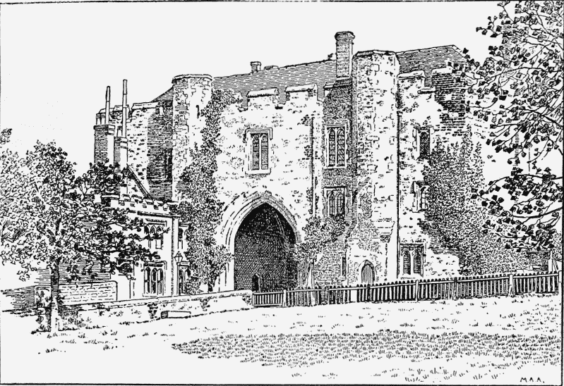
St. Albans: The Great Gateway, South Side
On the opposite side of the road to the inn is a house with an unusually interesting door-head of eighteenth-century date, inclosing a panel intended for an inscription and date, but apparently blank.
St. Michael's manor-house, which lies here, is described under St. Michael's parish. The lower part of Fishpool Street was known as Sally Path.
Along Verulam Road is Gombard House, the residence of the Rev. Francis Adye, and Verulam House, formerly the 'Verulam Arms.'
The ancient Saxon earthen camp known as Kingsbury Castle, elsewhere described, lies on the south side of this road, which is now being rapidly built over.
If St. Albans town may be said to be the successor of Verulam, it can claim an origin, so far as there is evidence on the point, as early as, or earlier than, any other town in the country, for there can be little doubt that Verulam existed before the invasion of Julius Caesar (c.50 B.C.); at all events it was undoubtedly the seat of the government of Tasciovanus, a British prince whose coins were struck here between 30 B.C. and A.D. 5. (fn. 43) The history of the town during the Roman occupation is recorded elsewhere. As to what happened to Verulam after the withdrawal of the Roman legions in A.D. 410, we have but little information. We know, however, that the town was not deserted, and probably had a considerable population for some years after the Roman legions had left, and a few of the British imitations of Roman coins found on the site may possibly be as late as the sixth century. If we are to place any value upon the stories originating with that most unreliable chronicler, Geoffrey of Monmouth, the witness of these coins will bring us to the date when Uther Pendragon, father of the celebrated King Arthur, defeated the Saxons at Verulam in 512 and later took up his residence there till his death in 516.
It seems probable that this district was subjugated by the Saxons during the sixth century, when what remained of Verulam was, we may imagine, destroyed.
Verulam, however, as a town was not directly succeeded by St. Albans, but by Kingsbury, which arose on the north of the lake or pool that protected the northern side of the Roman city. Kingsbury was a Saxon town of considerable size, protected by earthen ramparts on all sides, (fn. 44) and consisting probably of dwellings of wattle and daub. The date of its foundation is unknown. It may have been established by Offa when he superintended the building of St. Albans Abbey at the end of the eighth century, and the fact that it was a royal town governed by the king's officers independently of the abbey lends colour to this suggestion. While Kingsbury was a flourishing town Abbot Wulsin, the sixth abbot of St. Albans, about 950 enlarged the present town of St. Albans, (fn. 45) which had arisen around the abbey, and caused it to be inhabited by the people of the adjoining districts, establishing a market and assisting with money and building materials those who came. He also built the churches of St. Peter on the north of the town, St. Stephen on the south, and St. Michael within the ancient town of Verulam on the west. It is curious to notice that there was apparently no provision for the spiritual welfare of the inhabitants of the royal town of Kingsbury; possibly a timber church existed there, but there is no evidence of it. When the abbot's town became important, disputes arose between its inhabitants and those of Kingsbury. According to the story of the monks, the men of Kingsbury, being the king's men, looked down upon the abbot's men and oppressed them. The abbot, seeing the difficulties which were likely to ensue, purchased (957–75) from King Edgar the great fishpool which was the principal source of livelihood for the men of Kingsbury, and drained it, hoping thus to impoverish the town. (fn. 46) This, however, had not the desired effect of putting an end to the quarrels, therefore Alfric when chancellor of King Ethelred (978–1016) purchased Kingsbury from the king, and later, having taken the religious habit at St. Albans and having become abbot, levelled the whole town except a small bulwark (propugnaculum) near to the monastery, which the king would not permit to be thrown down, that some vestige of his royal residence might remain. (fn. 47)
Thus matters continued under the dual control of the officers of the king and the abbot, evidently with frequent conflicts, till about 1152, when Stephen happening to visit the abbey, the abbot prostrated himself before the king at the altar of St. Stephen, in the south transept of the abbey church, and prayed that the remains of Kingsbury might be destroyed. The king consented, and the last remains of the town were levelled, and the site ploughed and sown. (fn. 48)
It is curious to notice that the site of the town of Kingsbury, although close to the monastery, was carefully excluded from the borough of St. Albans till the borough boundaries were revised in 1879. It is probable, therefore, that the ancient borough boundaries were defined before the destruction of Kingsbury. (fn. 49)
St. Albans has often been connected with the general history of the nation. In May, 1141, the Empress Maud, after the defeat of Stephen at Lincoln, stayed at St. Albans, on her way from Reading to London to be crowned. Here she was received with honour and rejoicing, and later gave audience to a deputation from London to arrange terms for her reception. (fn. 50) Two years later Stephen, having again the ascendancy, and suspecting the powerful Geoffrey de Mandeville, earl of Essex and sheriff of Hertfordshire, of negotiating with the Empress, sent to arrest him at St. Albans. On the arrival of the king's messengers the knights of the abbey, considering the king's action a violation of sanctuary, resisted them. In the tussle which ensued the earl of Arundel was unhorsed and nearly drowned in the Ver at Holywell Bridge. Geoffrey, however, was taken prisoner and carried to London. (fn. 51)
There are many later records of visits of royal and important personages to the town and monastery of St. Albans. King John visited the town soon after his coronation, (fn. 52) and stayed there many times during his struggles with the barons. (fn. 53) In 1213 he convened a council at St. Albans, (fn. 54) and the same year appointed Robert of London guardian of the abbey. (fn. 55) There also he had letters of suspension of the archbishop of Canterbury read out, and made his plans against the barons. (fn. 56)
In 1217 his favourite, the infamous Faulkes de Breauté, sacked the town and extorted £100 in silver from the abbot. (fn. 57) John's successor, Henry III, also stayed at St. Albans several times, on one occasion offering prayers for Jane countess of Flanders on hearing of her death.
Thomas count of Flanders visited St. Albans in 1244, (fn. 58) and about this time Richard of Cornwall went there on his way to start on his crusade. (fn. 59) Queen Eleanor, wife of Edward I, (fn. 60) when coming to pay a visit to the monastery, was surrounded by the women of the town, who implored her to influence the abbot to let them use their own hand-mills. (fn. 61) When the body of the same queen was being taken to Westminster for burial, St. Albans was one of the resting places. The whole convent came out in their copes to meet the procession at St. Michael's and escorted it to the abbey. (fn. 62)
In the fifteenth century St. Albans played an important part in the Wars of the Roses. In January of 1455 the king released Somerset, who had been imprisoned in the Tower. York's friends immediately rallied round him, and marched straight on London. Somerset and the king hastened to meet them, and the two armies encountered each other at St. Albans. The king's forces were concentrated in St. Peter's Street and the Market Place, while the army of the duke of York was drawn up in a field called Keyfield, belong ing to the Cross Keys Inn, which stood on the site of the present London Road. From this field Sir Robert Ogle suddenly, with 600 men of the Marches, forced his way through into the town and seized the Market Place before any man was aware. The alarm bell was rung, presumably from the Clock Tower, and the king's men 'got to harness' and attempted to drive the Yorkists back. A fierce fight ensued. The dead and wounded lay on all sides. For a time the issue seemed doubtful, but at length the king's troops took to flight, fleeing hither and thither, and sheltering in the gardens and thickets outside the town. (fn. 63) The king himself took shelter in a little house in the town, and lay there till he was found by the duke, who took him to the abbey, and after he had rested escorted him to London. (fn. 64) The corpses were left lying in the streets till the abbot prevailed upon the duke to have them decently interred. (fn. 65)
Six years later, in 1461, Queen Margaret with her northern forces marched south, spoiling and plundering on their way, but on reaching St. Albans they found the king's army awaiting them. (fn. 66) A few bowmen brought them to a stand near the Great Cross or Market Cross, and then they beat a retreat eastward. From here they tracked northwards to St. Peter's Street, where they had a sharp skirmish and lost many of their men, but they pressed on to Bernards Heath. Here a fierce and long fight ensued; but though the Yorkists made a strong stand at first they were soon worn out and fled, (fn. 67) the queen's troops following them till nightfall. (fn. 68)
Queen Elizabeth paid three visits to St. Albans in the years 1570, 1573, and 1577, staying on each occasion at Gorhambury, the home of her favourite, Sir Nicholas Bacon, Lord Keeper of the Great Seal. At one visit she was presented with an address by the mayor, and in 1570 granted a wine charter to the town. (fn. 69)
During the civil wars of the seventeenth century St. Albans took its share in the history of the period, the town being held throughout the war by the Parliamentary forces. The first and perhaps most dramatic incident was the seizure of Sir Thomas Coningsby, the high sheriff, in the Market Place by 'Captain Cromwell' with a party of horse, on 14 January, 1642–3, while reading a royal proclamation for raising train-bands. (fn. 70) Shortly afterwards in the same year a Parliamentary garrison was maintained at St. Albans and the town put in a state of defence. In October following the earl of Essex removed his head quarters from Windsor to St. Albans to keep in check Prince Rupert with the king's forces, then in Bedfordshire. (fn. 71) It was the head quarters of Fairfax in 1647 at the time of his advance on London, and in June of that year the king passed through the town as a prisoner. (fn. 72) In the following year St. Albans played an important part in the history of the country. Fairfax again made it his head quarters, and here were brought great numbers of Royalist prisoners from Colchester and the north. These were kept in the abbey and neighbouring churches, where records of their sojourn still remain in writings on the walls and entries in the parish records. In October and November, 1648, Fairfax and his council of officers met in the abbey church and drafted the 'Great Remonstrance,' dated 16 November, which practically settled the fate of the king. (fn. 73) A garrison was still maintained here in 1649, for in June of that year the people of the town incited the soldiers to mutiny and there were riots in consequence. (fn. 74) Again, at the time of the Restoration, General Monk made St. Albans his head quarters in January and February, 1659–60, amidst great rejoicings. (fn. 75)
There is an old custom in St. Albans still extant which has probably been in existence for many centuries. It is that of eating 'Pop-Lady' buns on New Year's Day. (fn. 76) These are small sweet cakes of human form, having currants to mark the features. At Kidderminster a similar custom prevails in which the seven currants used are supposed to denote the seven-fold gift of the Holy Spirit. (fn. 77) These, probably, like the pain bénit of Brittany, are of pious origin, and were intended to represent the Blessed Virgin Mary. (fn. 78) Doubtless opponents of the Roman Catholic religion scoffingly termed these cakes Popes' Ladies, and hence their present name.