A History of the County of Middlesex: Volume 2, General; Ashford, East Bedfont With Hatton, Feltham, Hampton With Hampton Wick, Hanworth, Laleham, Littleton. Originally published by Victoria County History, London, 1911.
This free content was digitised by double rekeying. All rights reserved.
'Ancient earthworks', in A History of the County of Middlesex: Volume 2, General; Ashford, East Bedfont With Hatton, Feltham, Hampton With Hampton Wick, Hanworth, Laleham, Littleton, ed. William Page (London, 1911), British History Online https://www.british-history.ac.uk/vch/middx/vol2/pp1-14 [accessed 30 April 2025].
'Ancient earthworks', in A History of the County of Middlesex: Volume 2, General; Ashford, East Bedfont With Hatton, Feltham, Hampton With Hampton Wick, Hanworth, Laleham, Littleton. Edited by William Page (London, 1911), British History Online, accessed April 30, 2025, https://www.british-history.ac.uk/vch/middx/vol2/pp1-14.
"Ancient earthworks". A History of the County of Middlesex: Volume 2, General; Ashford, East Bedfont With Hatton, Feltham, Hampton With Hampton Wick, Hanworth, Laleham, Littleton. Ed. William Page (London, 1911), British History Online. Web. 30 April 2025. https://www.british-history.ac.uk/vch/middx/vol2/pp1-14.
In this section
ANCIENT EARTHWORKS
Although earthworks are the most durable of all man's handiwork when exposed to Nature alone, they cannot withstand the encroachments of the builder. With the continual spread of habitations for the workers of commercial London, and the surrounding cultivation of the land for the vegetable supply of so great a host, there is little cause for wonder that the few works which are known to have existed in the county of Middlesex have been all but obliterated. When we consider the exceptionally small size of Middlesex as a county, that it contains the two cities of London and Westminster, and the amazing extension of their borders, the marvel is that any ancient works remain.
The natural features of the county lent themselves to no mighty defensive works; it was no locality for habitations, seeing that it was generally of a marshy nature and subject to great inundations, it was itself a defence for more inland territories. Guest remarks, 'I have little doubt that between Brockley Hill (fn. 1) and the Thames all was wilderness from the Lea to the Brent.' Prehistoric and Roman camps were apparently few; the Roman stations at Staines (Pontes) on the Thames, and Brockley Hill (Sullonicae) near Elstree, have no earthworks to indicate their former sites; while the fosse formerly surrounding the walls of London now no longer remains.
One great dyke in part remains to record the boundary line between British tribes or Saxon provinces; but the only type of earthwork much in evidence in the county is that of Homestead Moats, and those are fast disappearing beneath the foundations of houses.
Moats are more thickly clustered on the north of London than elsewhere; they surround the sites of manor houses and farmsteads in close proximity to the neighbourhood of Barnet. When it is remembered that this was the scene of two engagements during the Wars of the Roses, that two other battles were fought within a short distance at St. Albans, and how marauding bands were the certain accompaniment of fighting forces in those days, it will be seen how necessary a precaution it was for people of substance to safeguard their property by the best means then known.
The surface of the county, however, has altogether changed since Nichols described the moated mansion of Balmes within the parish of St. Leonard Shoreditch. Whilst passing over Willoughbys and other demolished earthworks, we cannot ignore those that have disappeared in more recent years, otherwise our task would be light; yet the few remaining works are apparently doomed in the near future unless the growth of London be arrested.
From the general classification of earthworks it is needful to quote those classes only which are represented in this county.
Class C.-Rectangular or other simple inclosures, including forts and towns of the Romano-British period.
Class F.-Homestead Moats, such as abound in some lowland districts, consisting of simple inclosures formed into artificial islands by water moats.
Class G.-Inclosures, mostly rectangular, partaking of the form of F, but protected by stronger defensive works, ramparted and fossed, and in some instances provided with outworks.
Class X.-Defensive works which fall under none of these headings.
To which is added T for Tumuli.
Out of the four examples of Class C until recently existing one only in part remains, the other three have been obliterated, one of them as late as the year 1906.
The greatest number of earthworks remaining are of Class F, among them are some representative examples, whether surrounding the grounds as that at Fulham Palace, or washing the walls of the house, as Headstone.
In class G two examples are placed, one of them surrounding the formerly strong fortress of the Tower.
The most stupendous earthwork of Middlesex is found in Class X, and the Grimes Dyke will probably survive all other works of this nature.
One tumulus survives, possibly the most ancient earthen monument in the county.
Enfield Camp
SIMPLE DEFENSIVE INCLOSURES
[Class C]
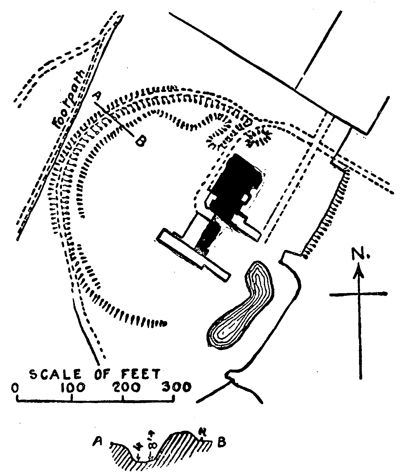
Enfield (vii, 6 and 7).-In Old Park, nearly a mile south-west of Enfield Town Station, is the most extensive fragment of a camp in the whole county. Its existence is due to a situation in private grounds whilst its partial demolition is owing to the laying out of a garden to the house within the circuit of the camp over a century ago.
A little more than a semicircle-the north, west, and south-west- remains of a circular camp upon the top of a shallow hill. The extant portion consists of a vallum and fosse. The vallum rises from the ground level on the south and quickly attains a height of 5 ft.; in the middle of the western side it rises to 8 ft., declining somewhat towards the north it again rises towards its termination at the northeast. The vallum is broad and a path has been made on the top, probably at the expense of a greater original height, which is now about 2 ft. above the interior area except at the north where the vallum stands boldly above the ground which is the same internally and externally at this spot. A path pierces the vallum at the north-east, but a very small portion of the latter remains on the eastern side of the path. The plan of the works in the neighbourhood of the path is in perfect harmony with an original entrance between an inturned vallum, containing a guard-room within the curve and a platform obtained by the widening of the vallum; at the same time this arrangement may possibly have been made when the house was built, whereby an even pathway might be obtained, and by the removal of soil from the interior area a garden bower formed-on the site of the possible guard-room-for which purpose this hollow is now used. Around the north-west is a portion of the fosse, from 3 ft. to 4 ft. deep, which has been raised above its original depth to form a gravelled path. On the south-east is a modern pond, fed by a spring in its northern part, at a spot which would have been immediately outside the original circuit of the vallum, and therefore in the fosse. Thus the constructors of the camp may have provided a water-girt stronghold in addition to a water supply. A bank on the north-east of the pond is modern.
Harmondsworth Camp
Hounslow Camp
Harmondsworth (xix, 8).-Three quarters of a mile north-east from Heath Row, immediately south of the Bath Road, a small square camp, about 380 ft. square, was extant until the autumn of 1906. It is now ploughed perfectly flat, leaving no trace of the work. Stukeley supposed it to have been one of Cæsar's stations after he crossed the River Thames in pursuit of Cassivellaunus; a conjecture that has become local tradition, firmly held by the inhabitants of the neighbourhood.
Isleworth (xx, 3).-To the east of Osterley Park was a small circular earthwork 200 ft. in diameter inclusive, with the entrance on the eastern side.
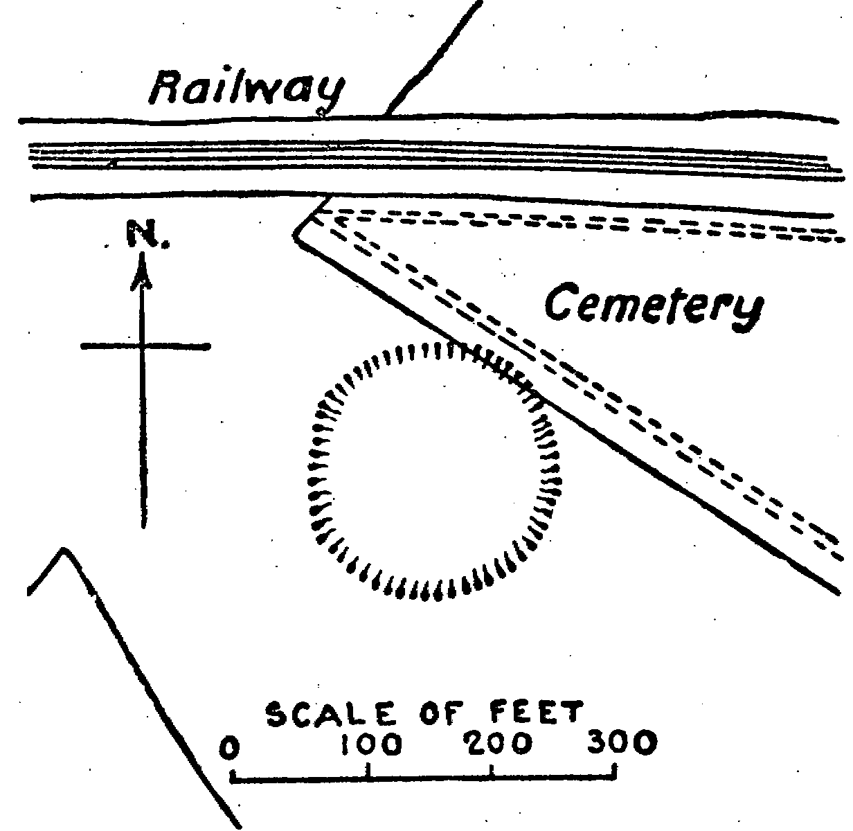
Twickenham (xx, 10).-A circular camp 200 ft. in diameter was situated on Hounslow Heath against the boundary of the cemetery, south of the railway. It has now all but perished, the slightest depression in the ground is only just discernible.
HOMESTEAD MOATS
[Class F]
Acton (xvi, 9): 'Friars' Place Farm.' Within a quarter of a mile north of Acton Station on the Great Western Railway are the remains of two moats, of which one will be classified under G. That which we now consider is a water moat, but only two sides remain, the southern, which is about 50 ft. wide, and the western, which is considerably narrower. Lysons, in the Environs of London, considers this to have formed part of the lands given by Adam de Hervynton to the prior and convent of St. Bartholomew in Smithfield.
Edmonton (vii, 12): Moat House Farm, Marsh side, to the east of Lower Edmonton. The old Moat House was demolished in 1906 but the moat at present remains. This is a large oblong in plan, and although varying in breadth it averages about 20 ft., and is 8 ft. deep. The south-western side has been narrowed by the formation of a road. Near the north angle the water of the moat intrudes into the central area in a semicircular course, thus forming an islet. In the Ordnance Survey two small islands are erroneously inserted.
Edmonton (vii, 16).-A small quadrangular moat to the west of Angel Road Station has recently been filled up with earth.
Edmonton (vii, 15).-At Weir Hall, south-west of Millfield Training School, in the district of Upper Edmonton, is a moat, averaging 30ft. wide. The banks-a foot above the water-gently slope upwards towards the centre of the interior site, where a modern house now stands. At the south-eastern angle the water cuts off a corner of the inner area, thereby forming an island. It is fed by Pymmes Brook.
Enfield (vii, 8).-' Durant's Arbour,' half a mile north of Ponders End, was the name of the manor house of the Durant family in the fourteenth century. The name has survived the house and is now applied to the large square moat with the bridge on the north-eastern side.
Enfield (vii, 7).-A large moat formerly situated on the southeast of Enfield Town Station has recently been filled in and is now built over.
Enfield (vii, 6).-West of Old Park Farm, upon the Golf Links, is a diamond-shaped moat surrounding a small elevated area. At the western end is a cutting through which the moat is fed by a small stream which flows into the River Lea.
Enfield (ii, 16).-North-east of Enfield Lock Station, on Plantation Farm, is a quadrangular moat crossed by two bridges on the southern and eastern sides respectively.
Enfield (ii, 13): 'Camlet Moat.' In Moat Wood, north of Trent Park and south of Enfield Chase is a large moat, oblong in plan, with the entrance on the east. The house has long since been demolished. In the time of Sir Walter Scott it must have presented a similar appearance as now, for he mentions it as a place 'little more than a mound, partly surrounded by a ditch, from which it derived the name of Camlet Moat.' (fn. 2)
Finchley (xi, 8).-One mile south of Finchley is the long rectangular moat of the ancient manor house. It incloses a large oblong area but is divided by a public road. To the south of it, traces of other artificial work are being obliterated and it is difficult to determine their original form or use; but it is possibly the site of fish ponds.
Finchley (xii, 10): 'Ducketts' or 'Dovecots,' north-east of St. Mary's Church, Hornsey. The site of the manor house is surrounded by a narrow moat which is fed by water from the New River. A portion on the east has been filled in, and the bridge is on the western side.
Finchley (xi, 8).-Norden, in his Speculum Britannica, 1593, states that a hill or fort in Hornesey Park, and so called Lodge Hill, for that thereon for some time stood a lodge, when the park was replenished with deare; but it seemeth by the foundation it was rather a castle than a lodge, for the hill is at this time trenched with two deep ditches, now olde and overgrown with bushes.
This lodge, which was the property of the See of London from the twelfth to the fourteenth century, occupied a site to the south-west of the Manor Farm house on the north-east of Bishop's Wood, between Highgate and Finchley. Although it appears that the lodge was pulled down in the fourteenth century on account of its great age, traces of the moat are visible, from which it would seem that it was square in plan with sides 210 ft. in length. The moat was fed by a spring which still flows.
Fulham (xxi, 7).-The grounds of the Bishop of London's palace at Fulham are entirely surrounded by a moat which is crossed by two bridges. The moat is nearly a mile in circuit and incloses an area of 37 acres. It has been suggested that the moat was originally the fosse made for the protection of the Danish camp in A.D. 879; a conjecture formed solely on the Anglo-Saxon Chronicle, wherein it is stated that this year a body of those pirates camped at Fulham.
Hanworth (xxv, 2): Hanworth Castle Moat.-Why the moat should be known by this name is not apparent. It is situated in the grounds attached to the ruins of the Tudor building in which some of the youthful days of Queen Elizabeth were spent. A large square area, perfectly flat, and at a slightly lower level than the exterior banks, is surrounded by a moat averaging 45 ft. in width; each angle being broadened by the rounding of the angles of the interior site. At the south-eastern corner is a culvert, at which point the moat is supplied by water through a cutting locally called the 'Queen's River,' from its associations with Elizabeth, and the 'Cardinal's River,' from the belief that it was made by the order of Wolsey.
Harefield (ix, 12).-At Brackenbury Farm, 1 mile north-west from Ickenham, near the western bank of the River Pinn and fed by its waters, is a quadrangular moat inclosing a considerable area. The widest and deepest part is on the south, where it is 24 ft. broad, but it narrows to 9 ft. in width around the western side. The outer bank rises above the general level on the north side. The eastern side has been filled in within the last fifty years to enlarge the surface of the garden.
Harefield (ix, 12).-A quarter of a mile south-west of the last mentioned a small but perfect moat lies within a bend of the River Pinn, by which it is supplied. By being thus situated the eastern side and its two angles of the interior area are protected by two widths of water. The moat, which is walled on the inner side to a height of 6 ft., is 18 ft. wide, broadening to 28 ft. at the south-eastern corner. Access to the interior is gained on the western side.
Harmondsworth (xix, 3).-On the site of an Alien Priory-a cell to Rouen-and west of the ancient Tithe Barn, the course of a large rectangular moat may yet be traced, although all but a small portion at the north-east has been filled in. The remaining fragment is nearly 24 ft. wide. Although situated close to the River Colne the moat was supplied with water from the 'Duke's River,' on the west, and a spring rising on the southern side flows into the former, by which the interior site was doubly protected on the south-west.
Harrow On The Hill (x, 11).-On the west side of the hill, on the lower ground of the slope and west of the Northolt Road, a small moat remains in a perfect state in the grounds of The Grange. It is square with slightly rounded angles, 20 ft. wide between the sloping banks, which gently rise to 4 ft. 6 in. above the water.
Hayes (xv, 13).-One mile south-east of Hayes Station, and on the eastern side of the River Crane, a small moat surrounds the remains of the old house which was formerly the property of the archbishop of Canterbury. Rectangular at its two southern angles-where the entrance is situated-the moat narrows on the northern side, where it assumes an almost semicircular course.
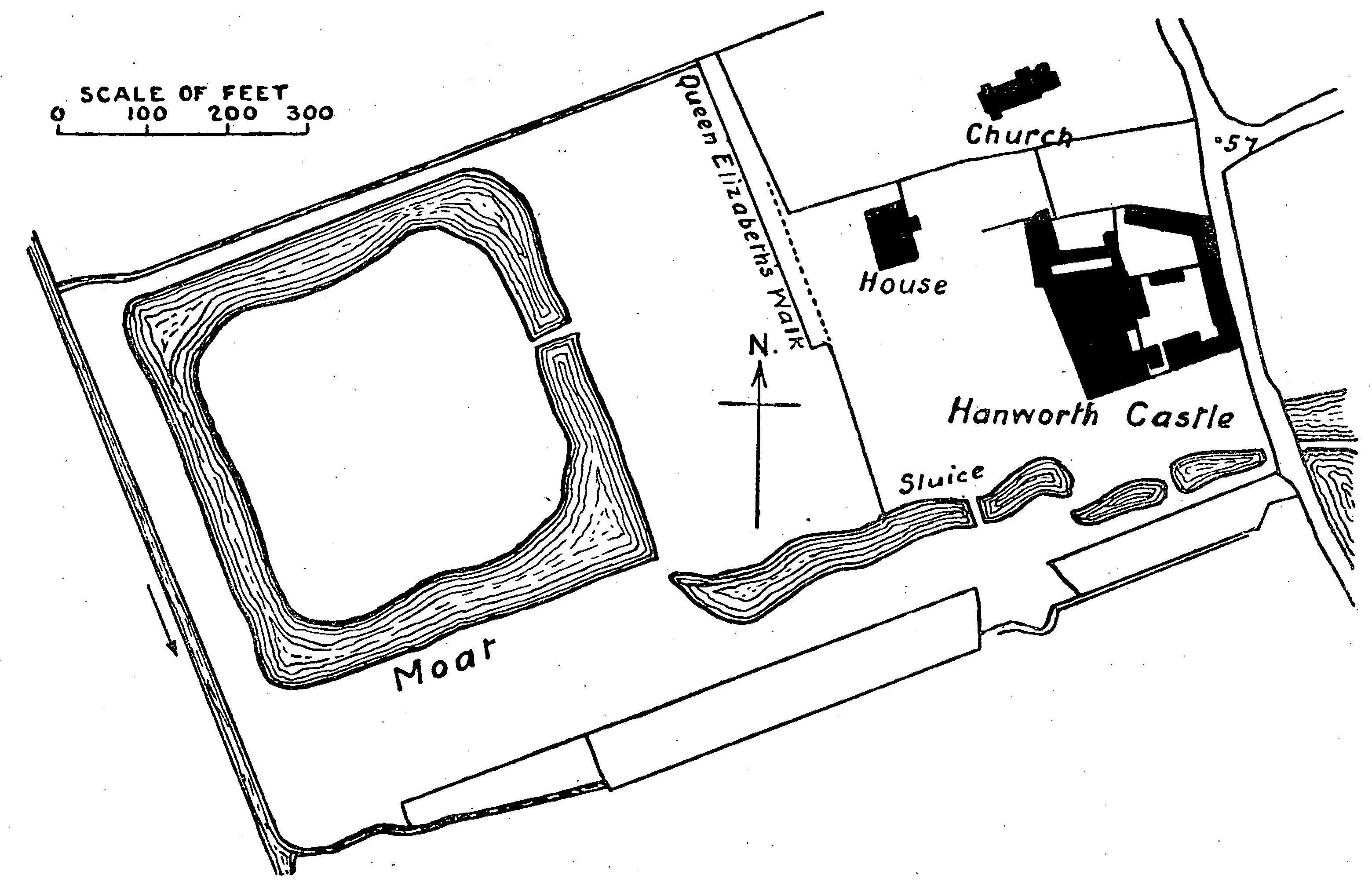
Hanworth Castle
Ickenham (ix, 16).-At Manor Farm, to the south-east of Ickenham village, a narrow moat takes a somewhat eccentric plan, and is evidently the work of two periods. The earlier moat was quadrangular, with the northern side joining the western at an acute angle. At some later date the eastern extremity of the northern trench appears to have been extended, while the eastern side of the moat- about 120 ft. from the south-eastern angle-was also turned eastwards in a line parallel to the northern extension; a fragment of the original moat remaining between them.
Isleworth (xx, 7).-To the west of Isleworth and of the River Crane is a square moat with the entrance on the east side.
London: Highbury (xii, 14).-The site of a moat in this parish is described by Nichols, (fn. 3) who, however, could not but associate it with the Romans. He says that in fields north-west of White Conduit House is a large inclosure called the Reedmote, or Six Acre Field, and supposed to have been a Roman camp; and at the south-east corner was the site of a square moated mansion, commonly called Jack Straw's Castle.
London.-Highbury Barn was also a moated site in the same parish.
London: St. Mary Islington (xvii, 2).-Beyond Bowman's Lodge, on the west side of Holloway Road, were the demesnes of Barnsbury Manor. The lines of the moated site of the manor-house could be traced until recently at the back of some houses fronting the Hercules Road. In 1835, when the outline was distinct, it was described as of irregular form.
London: St. Mary Islington (xvii, 2).-Some eighty years ago an earthwork was discernible in the gardens of the houses on the west side of Barnsbury Square. It was the moat of Mountfort House; but the southern side-almost in a line with the south side or the square- was so pronounced, being about 20 ft. wide and 8 ft. deep, that it gave rise to the idea that it was the southern fosse of a Roman camp, while about a century before this it had exercised the minds of the antiquaries of the eighteenth century. In those days the outer margin of the west side of the moat was apparently surmounted by a bank. (fn. 4) A fragment of the trench remains in the garden of Mountfort House.
Northolt (xv, 2).-At Down Barns, one and a half miles west of Northolt, a rectangular site is surrounded by a moat, of regular form except on the east, where, south of the entrance, it is of wider dimensions, and from it an irregular projection provides a pond.
Northolt (xv, 3).-A moat is situated quite near to the church which, from its exceptional character, demands a more detailed description. It stands upon high ground, and its banks are built up instead of having been excavated around the protected site. At the southern angle the moat is 12 ft. wide, and the central area rises to a height of 5 ft., overlooking the outer bank which is 4 ft. 6 in. high. The south eastern side varies in width from 9 ft. to 12 ft. The western angle is 36 ft. wide, narrowing towards the northern corner, where it is from 28 ft. to 30 ft. broad. On this north-western side the interior ground continues its former height; but the external bank is only 4 ft. in height. At the north the moat is again about 36 ft. wide, but the inner area attains a height of 7 ft. 6 in., while the outer bank is but 3 ft. At this point the water of the moat is drained into a pond 60 ft. distant, and although water is retained in the north-eastern side it is reduced in bulk. On the north-east, between the angle and the entrance, the moat is from 9 ft. to 10 ft. wide, the interior site is 8 ft. high, but this is the highest point in the outer bank, which is 6 ft. to 7 ft. 6 in. in height. The entrance is by a causeway 21 ft. broad. The site of the ancient house commands an extensive view of the surrounding country.
Perivale (xv, 4).-In a field west of the church and north-east of Horsendon Farm, may be seen the depressions in the land which mark the site of the old manor-house of Greenford Parva. The house has long since been demolished, but the moat still remains on three sides. The northern portion was filled up some fifty years ago.
Pinner (x, 3).-'Headstone' Manor, about a mile west of Holy Trinity Church, Wealdstone, was part of the archiepiscopal manor of Harrow. A notice of the house in 1344 opens the probability of the moat dating from about that time.
Pinner (v, 15).-A fragment of a circular moat is crossed by a road from Pinner to Harrow Weald. The southerly portion is 20 ft. wide, the northerly is serpentine in form, and the north-eastern has been filled up and farm buildings cover the site.
Ruislip (x, 9).-At Manor Farm, on the site of an Alien Priory that was a cell of the abbey of Bec, is an oval moat, surrounding an area of 350 ft. by 200 ft. The two entrances are on opposite sides of the long axis.
Ruislip (x, 9).-At Southcote Farm, half a mile south-west of Ruislip Reservoir is a quadrangular moat inclosing a site about 200 ft. long by 100 ft. broad; with the bridge on the south-western side.
Southgate (vii, 14).-In the grounds of Bowes Manor, northeast of St. Michael's Church, is a small irregular square moat around an islet measuring about 100 ft. across.
South Mimms (vi, 3).-Old Fold Manor Farm, north-west of Hadley Green, occupies ground formerly protected by a well-defined moat. The eastern side has been filled in and cow-houses occupy the site; but otherwise it retains its ancient appearance. On the southern side the moat is 18 ft. broad, increasing to 28 ft. on the west and the north. The depth to the water is from 4 ft. on the north, to 5 ft. on the south, the banks prettily clothed with wood and undergrowth.
South Mimms (vi, 3).-At Old Fold Farm, about one and a half miles from the last mentioned, in a westerly direction and close to the county border, is another moat of smaller size but more complete in its extant four sides. It is of oblong plan with a rounded broadening at the north-west corner. The entrance is on the east towards the southeastern angle.
South Mimms (i, 10).-At Blanche Farm, to the south of St. Monica's Priory, are the remains of that which was undoubtedly a moat, although the north-west and south-east are the only two extant sides.
ottenham (xii, 3).-Bruce Castle and Bruce Park formed onethird of the ancient manor of Tottenham. The spread of London's population is responsible for the recent levelling of the moat.
Tottenham (xii, 3).-'Mockings' was a sub-manor formed from that of Bruce, lying north of the high road. The moated manor-house stood on the south side of Marsh Lane.
Willesden (xvi, 6).-A moat similar to that in the moated meadow at Acton was situated near Willesden Junction until finally obliterated about the year 1890.
[Class G]
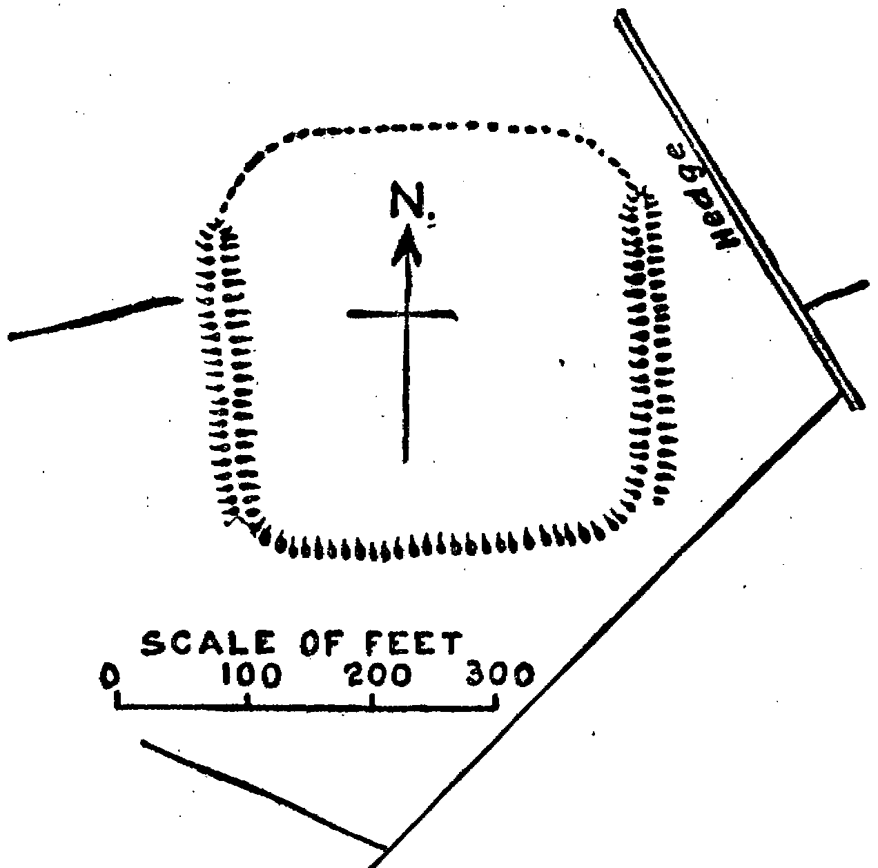
Acton (xvi, 9).-A quarter of a mile north of Acton Station on the Great Western Railway, in a field called 'Moated Meadow,' two fields westward of 'Friars' Place Farm,' are the remains of an earthwork which the Ordnance Surveyors have marked as a moat. From the slight indications extant it might possibly have formed a camp; but not enough remains to decide its original use.
The work occupies a slight eminence and consists of a shallow fosse, or dry moat, surrounding a quadrangular area. The two short sides-the western and eastern-are nearly parallel, the west is 89 ft. long, the east 136 ft. Of the two long sides the southern, 235 ft., is at right angles to the east and west; but the northern, 240 ft., takes a course to the north-east-by-east. The fosse varies from 41 ft. broad at the south-east, to 60 ft. at the north-west. On the north side, where the higher ground on the exterior makes it more assailable, is found the deepest part, which is 6 ft. A bank has surmounted the outer edge of the fosse, this is still discernible on all sides but the south, and averages 15 ft. wide. The latter feature may have led Lysons to speak of it as 'a deep trench enclosing a parallelogram (sic) . . . supposed to have been a Roman camp.'
London: The Tower Moat.-The precincts of the Tower of London are partly within London, but the greater eastern portion is in Middlesex. The first castle on this spot was built by the conquering Norman.
No account of earthen ramparts has been bequeathed to us, and the earliest mention of a fosse is of the twelfth century.
In 1190 William Longchamp, bishop of Ely and justiciary of England, while acting as regent during the absence of Richard in Palestine, caused a deep trench to be dug round the Tower of London, hoping to bring the waters of the Thames into the City, but after expending much from the treasury his labours proved fruitless. (fn. 5) It would be interesting to know the cause of this failure; possibly Longchamp could not complete the circuit on the river side, where it was exposed to the force of the tide, a difficulty overcome by the engineers of Henry III, who constructed the embankment and wharf, and protected it by piles; a work completed by his son Edward I.
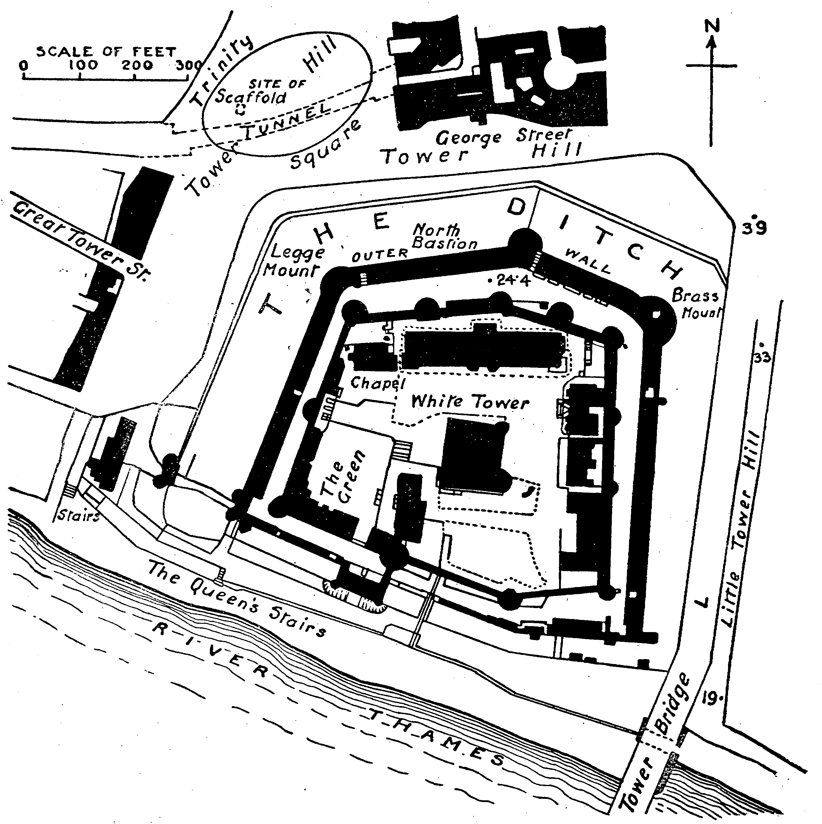
The Tower of London
When the Duke of Wellington was constable of the Tower he cleansed and deepened the moat; but its stagnant waters became so offensive that it was finally drained in 1843. The fosse is an irregular hexagon in plan, but it has been greatly altered from its original appearance in the sides and base to provide a drilling-ground for the garrison.
A vallum, of unknown dimensions, apparently a revetment, formerly occupied a position on the west side of the moat, for we are told that in 1316 the citizens pulled down a mud wall between the Tower Ditch and the city, which was supposed to have been constructed by Henry III; they were, however, compelled to restore the same, and were fined 1,000 marks for their lawlessness.
Tottenham (xii, 7). -A rectangular moat, surrounding an area now broken into two portions, is situated on 'Down Hills,' immediately south of the River Moselle. On the exterior of the western and eastern sides are broad banks 2 ft. in height.
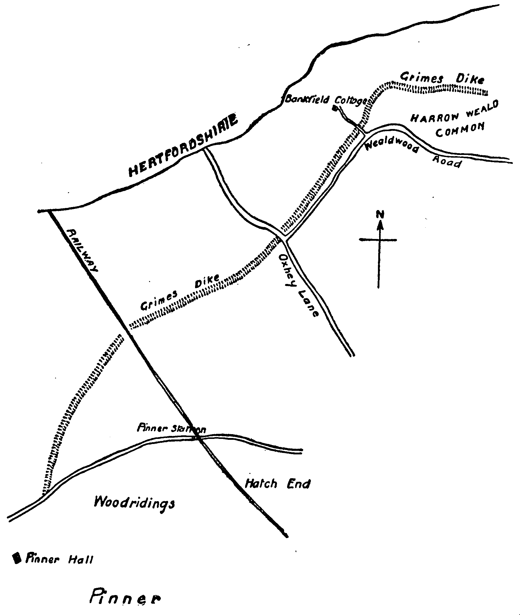
Plan of Grimes Dyke Through Harrow Weald And Pinner
MISCELLANEOUS EARTHWORKS
[Class X]
Brentford (xxi, i).- A possible line of defence to the Brent Ford is traced by Mr. Montague Sharpe, of which no definite signs exist; even the 'Old Ditch,' two sides of a rectangular fosse on the slope of Cuckoo Hill at the western extremity of Hanwell Ridge, and in a curve of the River Brent, is no more.
Harrow Weald And Pinner (v and x): Grimes Dyke.-Fragments of a boundary earthwork are in evidence over a distance of three miles within, and close to, the border of the counties of Middlesex and Hertfordshire, extending from Pinner Green to Bentley Priory. It consists of a vallum and fosse, the latter on the south-eastern side suggests that it was part of the south-eastern defence of the territories of the British tribe of the Catuvellauni.
The dyke appears to have been supported at the south-west extremity by the woodland of the Colne valley, and the other end was possibly connected with the ancient works on Brockley Hill. Thus the position of the dyke looked out upon the marshland which extended generally to the River Thames, and from the Brent to the Lea.
The work is most clearly to be seen to the south of Wealdstone Common, where the vallum rises 5 ft. from the interior, on the Hertfordshire side, is 63 ft. wide at the base, and has an escarpment of 12 ft. into the fosse; the latter has been too greatly disturbed to form an adequate idea of its former strength, but it is 5 ft. at its deepest part, and averages 15 ft. broad.
Passing the common, where the rights of carrying gravel have injured the configuration of the land, the most perfect section is found in private grounds; here the base of the vallum retains the same width, but is 15 ft. in height-now broken by a path on its escarpment, and the fosse widens to 21 ft; at one part this has been doubly dammed to form an artificial lake.
Pinner.-See Harrow Weald.
Wembley (xv, 4).-Horsa-Dun Hill, south-east of Harrow, shows slight traces of defensive works in two terraces on the southern side.
TUMULI
London: St. Pancras (xvii).-On Hampstead Heath, between Hampstead Ponds on the west and Highgate Ponds on the east, on a ridge of hill running north and south is a bowl-shaped tumulus, known as 'Boadicea's Grave.' It is a gradually sloping mound 10 ft. in height, with diameters-including the surrounding ditch-north to south 145 ft. and east to west 135 ft. The original ditch was within the cincture of the present one, which is modern. It was opened in 1894 by Mr. C. H. Read, who thinks it is a monument of pre-Roman burial by inhumation.
Teddington (xxv, 8).-Formerly situated in a field known as 'Barrow Field,' between Hampton Wick and Bushey, was a bowlshaped barrow, 96 ft. in diameter and 12 ft. 3 in. high. The tumulus, composed of burnt sand, was explored in 1854, when three interments were found, two after cremation and one by inhumation. The first on the ground level was accompanied by flint flakes and the bronze blade of a weapon; with the second, 4 ft. below the apex, were fragments of a very large half-baked urn and a flint hatchet-head; whilst in the third case the bones of an adult were buried superficially.