A History of the County of Middlesex: Volume 9, Hampstead, Paddington. Originally published by Victoria County History, London, 1989.
This free content was digitised by double rekeying. All rights reserved.
T F T Baker, Diane K Bolton, Patricia E C Croot, 'Paddington: Building after c.1800', in A History of the County of Middlesex: Volume 9, Hampstead, Paddington, ed. C R Elrington (London, 1989), British History Online https://www.british-history.ac.uk/vch/middx/vol9/pp182-185 [accessed 30 April 2025].
T F T Baker, Diane K Bolton, Patricia E C Croot, 'Paddington: Building after c.1800', in A History of the County of Middlesex: Volume 9, Hampstead, Paddington. Edited by C R Elrington (London, 1989), British History Online, accessed April 30, 2025, https://www.british-history.ac.uk/vch/middx/vol9/pp182-185.
T F T Baker, Diane K Bolton, Patricia E C Croot. "Paddington: Building after c.1800". A History of the County of Middlesex: Volume 9, Hampstead, Paddington. Ed. C R Elrington (London, 1989), British History Online. Web. 30 April 2025. https://www.british-history.ac.uk/vch/middx/vol9/pp182-185.
Building After c. 1800.
Acts of 1795, authorizing the Grand Junction Canal Co. to cut its Paddington branch (fn. 1) and the bishop of London and trustees for his lessees, the Morshead and Thistlethwayte families, (fn. 2) to build on what came to be called the Paddington Estate, opened the parish to London's sprawl. The bishop was to inclose c. 5 a. of waste and make a new lease for 99 years, the trustees could sublease up to 200 a. to builders for 98 years, and the bishop was to approve house plans and receive a third of the profits. (fn. 3) Later building Acts in 1804 allowed subleasing by private contracts, as an alternative to auctions, and the sale of brickearth or gravel (fn. 4) and in 1805 clarified the rents that might be charged. (fn. 5) Further Acts in 1808 led to negotiations with the City of London over water pipes which crossed the intended building land (fn. 6) and in 1812 authorized their purchase from the City. (fn. 7) An Act of 1826 'put the keystone into this expensive legislative arch', permitting the subleasing of up to 400 a. (fn. 8)
Approved building was slow to start: near the Tyburn turnpike the almost empty west side of Edgware Road contrasted with the Marylebone side in 1799, (fn. 9) although there was more housing along the Uxbridge road, and Paddington still had only 324 houses in 1801. (fn. 10) Delay may have been caused at first by the scarcity of capital during the war years. More lasting causes were probably drainage problems (fn. 11) and a policy of subleasing small amounts to mostly local builders, in order to ensure a high standard of housing. The success of the policy was ultimately shown, both in the grandeur of the first new houses in Connaught Place c. 1807 and in the elegance of the terraces put up over the next thirty years. (fn. 12) Thus there arose a fashionable suburb, Tyburnia, in the previously open south-eastern corner of Paddington between Edgware Road and the Uxbridge road.
In contrast to the slow realization of plans for Tyburnia, there took place a rapid growth of labourers' shacks. In 1806 and again in 1808 the agents of the Paddington Estate promised to let no more land for cottages, but in 1809 squalor caused mounting concern and in 1811 it was admitted that the ban on new leases had led to denser building on existing plots. (fn. 13) In 1811, when Paddington had 879 inhabited houses and a population of 4,609, (fn. 14) the vestry complained that 500 small tenements were inhabited by 2,107 people, of whom 948 had arrived during the past year, (fn. 15) and in 1812 the fringe of Tyburnia had acquired an evil reputation. (fn. 16) Several of the huts, near Edgware Road opposite George Street, were known in 1812 as Tomlins Town. (fn. 17) Most of them probably proved short lived, having been built on plots leased for only 4 or 5 years (fn. 18) and being liable to demolition at six months' notice. They were often rebuilt nearby, however, with the result that in 1816 there were perhaps 690 on the Paddington side of Edgware Road and many more in Marylebone. (fn. 19)
The need to control housing was also made urgent by the construction of the Grand Junction canal. Negotiations with the canal company were in train at the time of the bishop's first building Act, when it was clear that industrial growth would take place around the proposed basin south of Paddington green. (fn. 20) The canal was said to have attracted the labourers, many of them Irish, who were still squatting on the bishop's land in both Paddington and Marylebone in 1816. (fn. 21) Its construction set a limit to the northward spread of Tyburnia, marked by Grand Junction Road (later Sussex Gardens): terraces along the south side were built as part of the Paddington Estate and those on the north by the canal company; beyond lay meaner streets, reservoirs, wharves, and warehouses. Paddington green, the chief 18thcentury settlement, was cut off from Tyburnia and soon also, by the Regent's canal which had a few villas alongside it, from the fields to the north. (fn. 22)
The division between north and south was reinforced from the late 1830s by the G.W.R. line, with its terminus and goods station. Land was left between the railway and the canal, part of it intersected by Harrow Road, where working-class streets formed slums and where some larger canalside houses also deteriorated. Much cramped building around Paddington green and, farther west, railway stations at Royal Oak and Westbourne Park extended the belt of industry and poor housing. (fn. 23)
Although Tyburnia could not expand northward, its success, and the attractions of Kensington Gardens, encouraged building to the west, on land that was not all part of the bishop's estate. Tea gardens and other amenities flourished around the roadside settlement of Bayswatering, until in the mid 19th century they made way for the prosperous suburb of Bayswater. Paddington, like Kensington, shared in a twenty years' building boom from the mid 1830s, when rich merchants and professional men followed the aristocracy. (fn. 24) During the 1840s and 1850s loans from insurance companies, notably the London Assurance Group and Royal Exchange Assurance, enabled a few builders to plan on a more lavish scale. (fn. 25) In 1845 the G.W.R. Co.'s station was also thought to have furthered the recent and surprisingly rapid rise of a suburb which, in extent and respectability, surpassed any other. (fn. 26) North of Bayswater, middle- and upper middle-class streets, sometimes called Westbournia, reached to the southern end of Westbourne green; beyond, obliterating part of the old hamlet, lay the railway. (fn. 27)
In the 1860s growth temporarily slackened, as disputes arose among the beneficial lessees and as the upper middle class began to move farther from London. (fn. 28) By c. 1870, however, there remained open only the northern part of the parish. (fn. 29) Building activity soon revived, at least partly because of the provision of suburban and underground train services. (fn. 30) Leap-frogging the railway and canal, the Paddington Estate laid out middle-class avenues near Edgware Road, creating the greater part of Maida Vale. Humbler housing was built to the west, in St. Peter's Park, from the early 1860s. Lying north of Westbourne green, it was intended to be superior to the artisans' terraces put up from the 1870s in the northern part of Chelsea detached, which from 1900 was included in Paddington metropolitan borough as Queen's Park. (fn. 31)
Paddington was a comparatively small metropolitan borough and, for all its tree-shaded roads and squares, short of public open space. (fn. 32) Overall wealth, producing a very high rateable value, disguised wide disparities between districts, (fn. 33) as shown in residents' occupations, housing, and health. The contrast was particularly marked between the streets near Hyde Park and many of those along the canal, although even Tyburnia had pockets of poverty among its mews dwellings. (fn. 34) Further variety came from canalside industry, from hotels and lodging houses around the railway terminus, from early blocks of flats in Maida Vale, and from the shops and centres of entertainment in Westbourne Grove, Queen's Road (later Queensway), and Edgware Road. (fn. 35)
Restrictive building covenants on the Paddington Estate, although successful in attracting the well-todo, by the 1880s were blamed for having hindered improvements, even the provision of better drains. Market values accordingly suffered when tenants wished to sell their leases, most of which had 40-50 years to run. Although the Ecclesiastical Comissioners could dissent to lettings, general management was left to the trustees. There was criticism that less desirable houses were subdivided, annual rentals were hard to ascertain, and that no land was made available for purpose-built dwellings for the poor. (fn. 36)
In the period between the World Wars, Paddington claimed to cater for people of all incomes. Publicity was given to its shops, social amenities, and good communications with the City and west end of London. (fn. 37) The areas facing Hyde Park and parallel with Maida Vale remained fashionable. (fn. 38) More flats were built, nearly all, as in Kensington and Hampstead, for private occupation. (fn. 39) While some large houses became derelict and others were split into cheap lodgings, in the smarter districts there were divisions into expensive flats, besides conversions of mews dwellings. (fn. 40)
There was a high density of 106 persons to an acre in 1921, similar to that in Holborn and Islington but much less than in Southwark, Shoreditch, Bethnal Green, Stepney, and Finsbury. The five most crowded metropolitan boroughs, however, had all reduced their densities by 1931, whereas Paddington's had very slightly risen. Old contrasts within the borough persisted, to such an extent that in 1921 there were 61 persons to an acre in Bayswater's Lancaster Gate East ward compared with 180 persons to ]an acre in Harrow Road ward; the gap had narrowed only a little, to densities of 74 and 166.5, by 1931. (fn. 41) Rising infant mortality in 1931-2, caused by patches of overcrowding, led to the designation of Paddington, Kensington, and St. Marylebone as areas of housing stress, in addition to poorer boroughs north, north-east, and south-east of the City. (fn. 42)
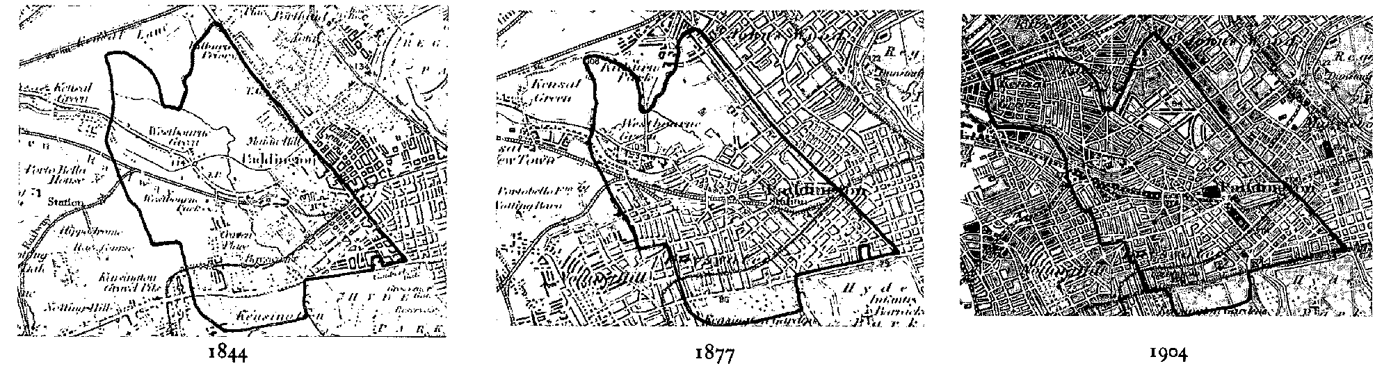
Paddington: Evolution Of Settlement, 1844-1904
(scale 1 in. to 1 mile)
Failure to lessen overcrowding may have been due both to municipal inactivity (fn. 43) and to the fact that the Paddington Estate still covered c. 600 a. or roughly half of the borough. The Ecclesiastical Commissioners, who had succeeded to the bishop's interest, were criticized for drawing so much of their profits from squalor and even from vice. In defence it was pointed out that the comparatively few houses subleased on weekly or monthly tenancies were well kept up, but that most sites, including many along the canal, had been surrendered for long terms and were beyond the estate's control. (fn. 44) A steep rise in the commissioners' Paddington rental, from £23,000 in 1920 to £84,000 by 1940, was attributed by them to reletting after the expiry of the early leases. On such occasions they inserted stringent conditions; in 1943 immorality was associated mainly with properties whose long leases were nearly at an end, notably in Maida Vale. (fn. 45)
Damage during the Second World War affected only c. 5 per cent of Paddington's acreage. (fn. 46) Much rebuilding took place after the war, although more slowly than in many parts of London. Paddington's density of 92.5 persons to an acre was the highest of all the metropolitan boroughs in 1951 and at 86 persons to an acre it remained so in 1961, the most crowded area still being along Harrow Road. (fn. 47) Paddington council, the L.C.C., and their successors laid out housing estates with terraces and tower blocks, in place of slums and some canalside industry. The changes which eventually came were striking: blocks of maisonettes by the canal were claimed to be the tallest in the country (fn. 48) and in 1967 Westminster planned what was described as the largest single comprehensive development yet seen in London, after a survey of 16,620 households had revealed that 86 per cent of the families were without their own lavatory or bath. (fn. 49) In 1985 Westminster owned 4,868 dwellings in south and central Paddington, which made up the council's housing area no. 3, and 4,166 in northern Paddington, including Queen's Park, which was housing area no. 4. (fn. 50)
Private building was more piecemeal: mainly hotels and flats on individual sites, with the exception of projects by the Church Commissioners, who succeeded the Ecclesiastical Commissioners and in 1953 bought out the beneficial lessees' interest in the Paddington Estate. (fn. 51) In order to escape the expense and embarrassment of owning decayed housing, the commissioners quickly sold much of their estate in southern Paddington or entered into partnerships with property companies. Work included the replacement of houses with office blocks in Eastbourne Terrace next to Paddington station and the rebuilding of much of stuccoed Tyburnia in the 1960s. (fn. 52) Thereafter sweeping changes were hindered by growing support for conservation. Four conservation areas were created under the Civic Amenities Act, 1967: Bayswater and Maida Vale in 1967, Westbourne in 1973, all three of which were later enlarged, and Queen's Park in 1978. (fn. 53)
Much conversion and some new building was carried out by housing associations. Mulberry Housing Trust, financed by Westminster city council and based in north Paddington, was founded in 1965, after bad conditions had received much publicity. In 1974 the trust merged with St. Marylebone Housing Association, which had been founded in 1926 and which continued to acquire properties in both Paddington and Marylebone, with funds from Westminster and from the Housing Corporation of ]the Department of the Environment. Some reconversion into larger flats was in progress in 1985, when all the homes were for renting. About one third of the association's tenants was of West Indian origin, about one third was Irish or from other immigrant groups, and the rest were mainly old people. (fn. 54)
Several other local bodies in 1974 amalgamated to form Paddington Churches Housing Association. It was financed mainly by Barnet and Camden L.B.s, Westminster, and the G.L.C., all of which continued their support in 1985, when most of the funds then came from the Housing Corporation. Converted property was solely for renting, although there were links with Sutherland Housing Association, which promoted cheap home ownership. Paddington Churches Housing Association, whose work had spread to many boroughs of north-west London, in 1985 managed 4,500 housing units, of which c. 1,800 were in Paddington. (fn. 55) Brent People's Housing Association was also active in Paddington, from 1975. (fn. 56) It was financed by Brent, Barnet, Harrow, and Westminster, and also at first by the G.L.C. and later by building societies. (fn. 57)
Although by 1983 Westbourne Grove had declined as a shopping centre and Queensway had grown more cosmopolitan, Tyburnia, including the rebuilt parts, and most of Bayswater remained expensive. The central belt, despite slum clearance, was still working-class and, with the lines of communication, separated the southern districts from the avenues of Maida Vale and the humbler streets stretching to Queen's Park. The local differences which had grown up with 19th-century Paddington thus survived. (fn. 58)
The population (fn. 59) rose from 1,881 in 1801 to 4,609 in 1811, 6,476 in 1821, 14,540 in 1831, and 25,173 in 1841. The rates of increase of more than 100 per cent from 1801 to 1811 and more than 50 per cent from 1831 to 1841 were higher than in any other parish in the later county of London. (fn. 60) Numbers had risen to 46,305 by 1851, 75,784 by 1861, 96,813 by 1871, and 117,846 by 1891. In 1901, after the addition of Queen's Park, the population was 143,976. It reached 144,923 in 1931 but fell from 125,463 in 1951 to 116,913 in 1961, and, after the wards had been reorganized as part of Westminster L.B., 95,958 in 1971.