A History of the County of Northampton: Volume 5, the Hundred of Cleley. Originally published by Victoria County History, London, 2002.
This free content was digitised by double rekeying. All rights reserved.
'Roade', in A History of the County of Northampton: Volume 5, the Hundred of Cleley, ed. Philip Riden, Charles Insley (London, 2002), British History Online https://www.british-history.ac.uk/vch/northants/vol5/pp345-374 [accessed 30 April 2025].
'Roade', in A History of the County of Northampton: Volume 5, the Hundred of Cleley. Edited by Philip Riden, Charles Insley (London, 2002), British History Online, accessed April 30, 2025, https://www.british-history.ac.uk/vch/northants/vol5/pp345-374.
"Roade". A History of the County of Northampton: Volume 5, the Hundred of Cleley. Ed. Philip Riden, Charles Insley (London, 2002), British History Online. Web. 30 April 2025. https://www.british-history.ac.uk/vch/northants/vol5/pp345-374.
In this section
ROADE
The medieval township of Roade occupied about 1,610 acres (fn. 1) in the north-eastern corner of Cleley hundred. (fn. 2) It was bounded on the north by the parish of Courteenhall, on the north-east by Quinton, and on the north-west by Blisworth, all of which lay in Wymersley hundred. On the south-west Roade abutted Stoke Bruerne and on the south-east Ashton. The land of the township rises gently from about 300 ft. above sea level in the south, where the boundary follows a tributary of the Tove, to about 400 ft. at its northern edge. A small detached portion of Courteenhall parish was added to the north-eastern corner of Roade in 1884, (fn. 3) which increased its area from 1,615 a. to 1,663 a. (fn. 4) This may have been the land over which there was a dispute between the two parishes in 1586, when the farmers of Courteenhall insisted that the land lay within their manor, even though it was next to Mauntell's Wood in Roade. (fn. 5)
In 1301 21 households were assessed to the lay subsidy in Roade, (fn. 6) and in 1524 about 30. (fn. 7) In 1674 79 households were assessed to the hearth tax, of which 22 were discharged through poverty. (fn. 8) Similarly, Roade was said to contain 80 houses in the early 18th century, (fn. 9) virtually the same figure as that returned in 1801, when the population was 345. There was a steady increase between then and 1851, when the number peaked at about 700. The population remained almost unchanged until after the Second World War, when large-scale local authority and later private house-building began. (fn. 10) There were nearly 1,000 people in Roade in 1951, about 1,500 ten years later, and 2,500 in 1971. (fn. 11) Although there was some further housebuilding over the following twenty years, a drop in household size meant that the population had fallen slightly (to 2,200) by 1991.
The medieval parish of Roade also included Ashton and Hartwell, extending in total to about 4,500 acres. The three communities were assessed together to the lay subsidy of 1301 as the 'vill of Roade with members', although households in Ashton and Hartwell were distinguished from those in Roade itself. (fn. 12) In the early 16th century the church at Ashton, which had hitherto been a chapelry of Roade, was made a rectory and the church at Roade reduced to the status of a chapel whose minister was a perpetual curate, known from the mid 19th century as a vicar. The other chapel in the medieval parish, at Hartwell, remained a perpetual curacy until it was united with Ashton in 1925. In 1987 the livings of Ashton with Hartwell and Roade were themselves united. (fn. 13)
The common fields of the three townships remained intermixed until an award was made in 1819 (fn. 14) under an Act of 1816 (fn. 15) to inclose Roade and Ashton and also effect some exchanges involving land in Hartwell, whose own open fields were not inclosed until 1828. (fn. 16)
The townships appear to have relieved their own poor and maintained their own highways from the 16th century, although only in the case of the Roade overseers do any records survive from before the 19th century to confirm this. (fn. 17)
The main pre-motorway route from London to Northampton, which leaves Watling Street at Old Stratford, runs from south to north through Roade towards the western side of the parish. (fn. 18) Three minor roads branch from the London road towards the west, one of which continues to Blisworth. On the east, a road forks from the London road near the northern edge of the parish to run south-east for about half a mile, where there is another fork junction, from which one road continues south-east to Hartwell and another runs due south to Ashton. The latter was realigned by the inclosure commissioners in 1819 so that it served Ashton village more directly; (fn. 19) before then it ran to the west of the village and continued south through the open fields of Ashton, as if heading towards a crossing of the Tove near Bozenham Mill, although in the early 18th century it petered out in the fields. (fn. 20) The route was known as a 'Portway' before inclosure. (fn. 21)
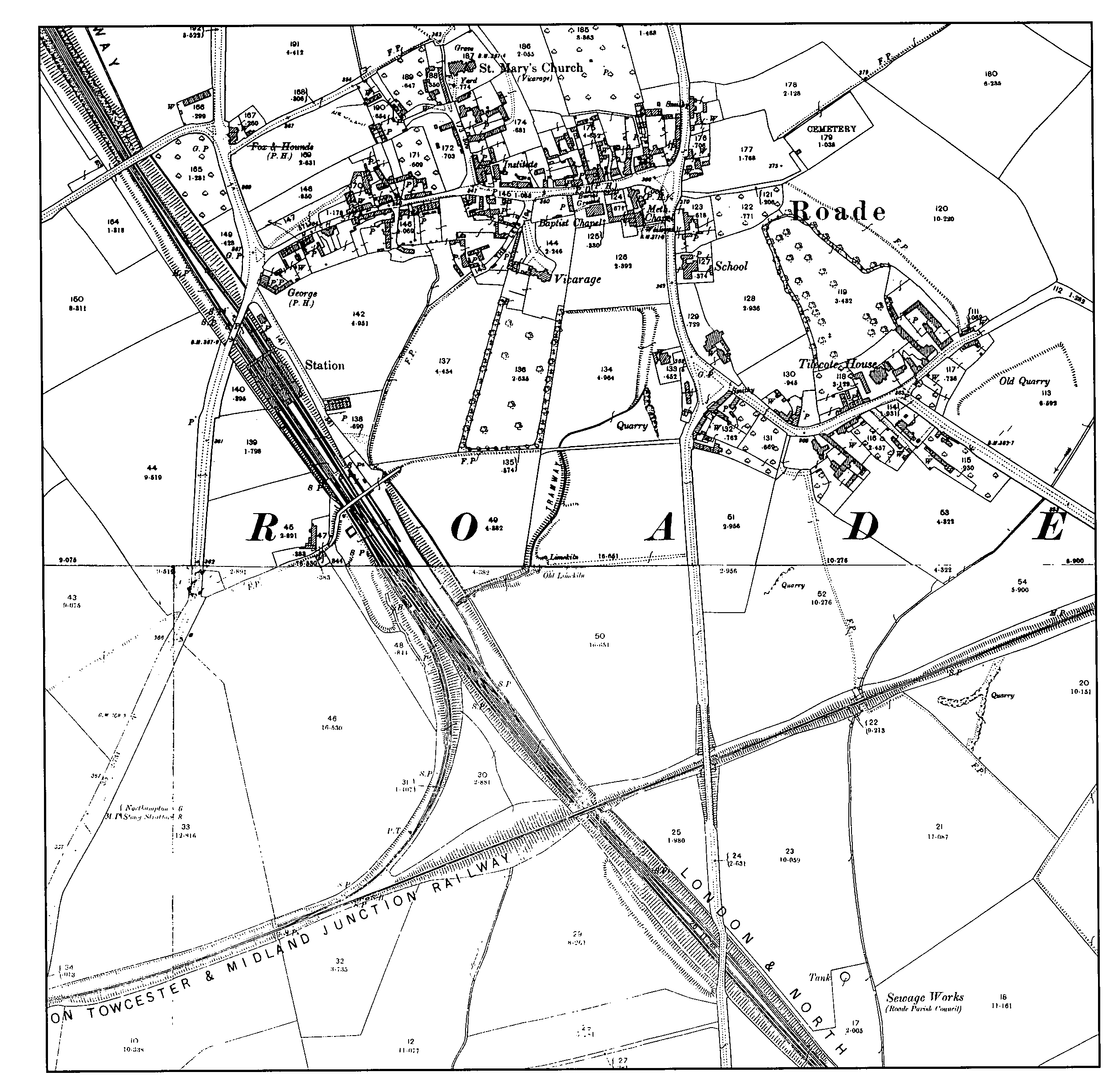
The London & Birmingham Railway, which crosses the parish in a north-westerly direction towards its western edge, was opened in 1838 and had a station at Roade, immediately to the south of the bridge carrying the London road over the line. (fn. 22) Most of the route through the parish runs in a cutting, which deepens towards the north. The line between Bletchley and Roade was quadrupled in the early 1880s; to the north of Roade Cutting the additional lines diverged to provide a more direct service to Northampton than the older branch from Blisworth. (fn. 23) Roade station was considerably enlarged as part of the building of the Northampton loop. (fn. 24) In 1890-1 a single-track railway between Towcester and the Midland main line near Olney was opened for goods (and for a few months passengers also), which crossed Roade from west to east, passing over the L.N.W.R. line a short distance south of Roade station, to which a west-facing spur was laid from what later became the Stratford-upon-Avon & Midland Junction Railway. (fn. 25) The Olney line closed in 1958 (fn. 26) and much of its route was later absorbed into adjoining fields. The former L.N.W.R. main line, together with the Northampton loop, was rebuilt in the 1960s as a 25 kV. overhead electrified route, (fn. 27) although Roade station was closed in 1964. (fn. 28)
Landscape and settlement.
A flint scraper and Roman coins and pottery were found somewhere in the parish before 1904; (fn. 29) in 1926 a Roman bronze pin was unearthed in the school garden; (fn. 30) and in 1933 a flint arrowhead and an Iron Age ring were discovered on the same spot at the school. (fn. 31)
The site of the earliest post-Roman settlement in Roade is presumably indicated by the position of the parish church, first mentioned in the 12th century, which stands roughly in the centre of the township, close to the junction of the main London-Northampton road and the road to Ashton and Hartwell. A village grew up to the south of the church, with most of the houses (certainly by the 18th century and presumably before) (fn. 32) strung out in a somewhat irregular fashion on either side of a main street running from the London road in the west to the road to Ashton and Hartwell in the east. The church stands about 200 yards north of the High Street, to which it is linked by a short lane. To the south-east of the main street there is a secondary cluster of older houses around the junction at which the roads to Hartwell and Ashton diverge, separated from the rest of the village until modern times by a couple of fields. This smaller settlement presumably also dates from the early Middle Ages.
As elsewhere in the district, the older surviving houses in the village, dating from the period of the Great Rebuilding, are built of local limestone, laid as coursed rubble, and were presumably all originally thatched.
About half a mile to the west of the church, close to the boundary between Roade and Stoke Bruerne, a third, smaller settlement grew up on an estate named Hyde, granted to the monks of St. James's abbey, Northampton, in the 12th century. (fn. 33) By the early 16th century, the hamlet seems to have shrunk to the single large farmhouse shown in 1727, (fn. 34) in origin the capital messuage of the abbey's estate, of which the oldest portion dates from the 14th century. (fn. 35) A medieval dovecote survives in the grounds of the house, and until they were drained in the early 19th century there were also fishponds at Hyde. (fn. 36) The abbey had a water-mill at Hyde from at least the 12th century, which went out of use in the 16th century. (fn. 37)
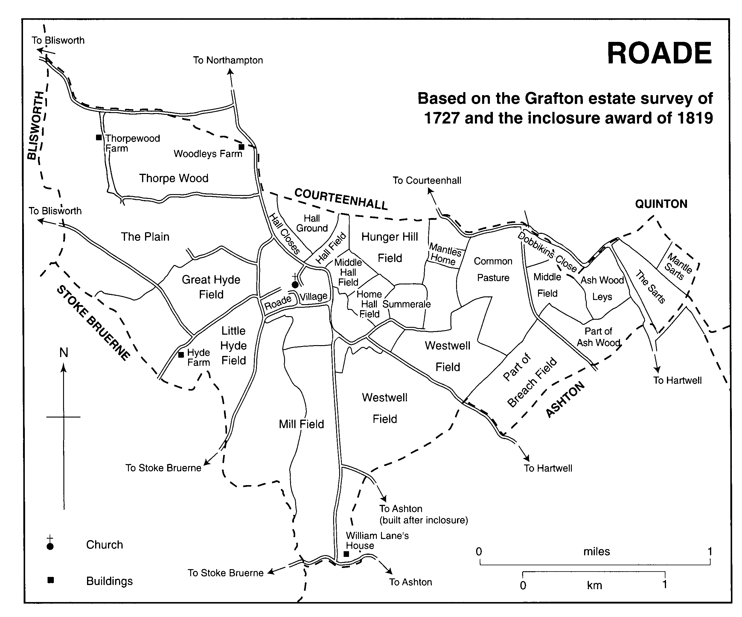
ROADE
Based on the Grafton estate survey of 1727 and the inclosure award of 1819
Most, but by no means all, the land of the township outside the village and the hamlet at Hyde was cultivated as common arable in the Middle Ages; there were also common meadows alongside the stream which separates Roade from Stoke Bruerne. There were evidently two sets of open fields in the medieval parish. One belonged to Hyde, whose fields lay to the north and south of the lane running from the main Northampton road to the capital messuage there. The second, presumably shared by the other estates with land in the township, consisted of Hall Field to the north of the village, Mill Field to the south, and West Well Field to the southeast. In addition, a small part of Breach Field, most of which lay in Ashton, was in Roade. (fn. 38)
Considerable areas of land to the north-west and north-east of the village clearly lay outside either set of open fields. The north-eastern corner of Roade does not quite extend into the modern Salcey Forest (whereas Ashton and Hartwell do), but in 1727 the closes there were named 'The Sarts' (i.e. assarts), (fn. 39) and, immediately to the south-east, part of Ash Wood (most of which lay in Ashton and, like Rowley Wood further south, appears to be a remnant of Salcey) (fn. 40) lay in Roade until 1747, when it was cleared. (fn. 41) No farmsteads were established in this area, whereas in the north-west of the parish Thorpewood Farm, first recorded under this name in 1662, (fn. 42) and Wood Leys Farm, which also dates from the mid or late 17th century, (fn. 43) both stand within a group of old inclosures that in origin are presumably assarts from woodland. Thorpewood remained a farm until modern times, whereas Wood Leys had become the New Inn by the early 19th century before reverting to a farmhouse by 1875. (fn. 44)
In the extreme south of Roade township there was a small parcel of old inclosure on the edge of Ashton village, on which a large house was built in the early 17th century, which was demolished in the mid 18th century. (fn. 45)
After the mill at Hyde fell into disuse, the farmers of Roade, like those of several neighbouring parishes, appear mainly to have used Bozenham mill, on the Tove in Hartwell. (fn. 46) In Roade itself, there was a windmill in the fields south of the village in 1779 (fn. 47) and another near the Hartwell road south-east of the village in 1827, (fn. 48) which had gone by the 1830s. (fn. 49)
Some common arable in the north-west of the parish was inclosed by agreement sometime between 1727 and 1768; (fn. 50) most, however, survived to be inclosed, together with the open fields of Ashton, which extended into Roade, in 1819. (fn. 51) After inclosure the Grafton estate let about half their land in Roade to a single tenant, who occupied a farmhouse on the south-eastern edge of the village, and the rest in blocks of accommodation land. (fn. 52) Neither they, nor any of the smaller owners, built new farmsteads out on the former open fields.
Within the village, there was piecemeal rebuilding of houses, shops and pubs in the 19th century, in brick as well as stone, creating what in 1953 was described as a 'hotch-potch of old and new' in the High Street. (fn. 53) There was little expansion of the built-up area, which in the late 19th century was much the same as in the early 18th. (fn. 54) Even though the number of houses had roughly doubled in the intervening period, (fn. 55) this growth had been almost entirely accommodated by infilling. Neither the arrival of the railway in 1838, nor the widening of 1882, had much effect on the topography of the village. Apart from the station buildings themselves, a new inn was erected on the main road nearby in 1839. Originally named the Robert Stephenson after the engineer of the London & Birmingham Railway, it became the George in the early 1840s. (fn. 56) Other new public buildings included the Wesleyan church of 1875 (considerably enlarged in 1908) and the board school of 1876, which stood almost opposite each other on Hartwell Road. (fn. 57) A small church institute was built on the north side of High Street in 1885. (fn. 58)
The largest new house built in Roade in the 19th century was the Vicarage, erected in 1844 in nearly 5 a. of garden to the south of High Street. (fn. 59) A few other large detached private houses date from the same period but, even after the direct railway link was opened in 1882, Roade did not develop into a residential village favoured by Northampton professional and business men who wished to move out into the country. (fn. 60) Nor was there much growth of industry. Limestone quarrying was carried on at various sites to the south of the village but not on a scale sufficient to transform the landscape. The most extensive workings before the First World War lay between the Vicarage garden and the road to Ashton, from where a tramway ran down to tipplers at a siding in the L.N.W.R. goods yard. (fn. 61) During the 1920s quarrying moved to the other side of the main line, in the angle between Stratford Road and the Olney branch, where again output was sufficient to warrant a short tramway. (fn. 62)
Just before the First World War a London company built a floor polish factory near the station. This failed after a few years but the site was taken over by a former employee, C. T. Cripps, who established Pianoforte Supplies Ltd. there, making light castings and other products for both piano manufacturers and other markets, especially the motor industry. The company gradually expanded to occupy a large area between the railway and the Ashton road on the southern edge of the village (including the site of the former quarry and tramway) as well as acquiring a considerable acreage of farmland. (fn. 63)
Pianoforte Supplies were, from the 1930s, by far the largest employer in Roade and a somewhat anomalous presence in what was otherwisestill mainly a farming community. Their large and well-equipped canteen, opened in 1938, became a focus for village social events both during and after the war; (fn. 64) when the company erected new buildings on Ashton Road in 1965 a branch bank (which closed in 2000) was included in the scheme to the benefit of the whole community. (fn. 65) The company's founder was chairman of the parish council in the 1920s and from 1950 a member of the R.D.C. His presence on the district council and his firm's position in the village both helped to ensure that Roade received a generous allocation of local authority housing in the 1950s. (fn. 66) Cripps was also an active churchwarden (fn. 67) and took the lead in ensuring the success of the village's 1953 Coronation celebrations. (fn. 68) Thanks to his munificence, Roade acquired one of the best club cricket grounds in the county in 1956 (fn. 69) and a bowling green a year later; (fn. 70) he also donated a swimming pool to the secondary school, of which he was a governor. (fn. 71) As a local reporter noted in 1969, 'they do things in style in Roade', largely thanks to the generosity of Sir Cyril Cripps. (fn. 72)
Roade Village
Proposals for a village hall in Roade originated in the 1920s, (fn. 73) and were revived after 1945, (fn. 74) although in 1958, after the assembly hall at the new secondary school became available, a fund-raising committee decided to use the money in hand for equipment at the recreation ground. (fn. 75) The question was reopened in 1961 (fn. 76) and in 1967 a public meeting voted in favour of what was now called a community centre, (fn. 77) a project merged the following year with a scheme for larger playing fields. (fn. 78) In 1970 plans were approved for a hall of about 2,000 sq. ft. (fn. 79) In 1974, facing rapidly rising costs, the Community Centre and Playing Field Association decided to erect a prefabricated wooden hall, which was rebuilt in brick in the 1990s. The playing fields, opened in the 1960s, were also gradually upgraded, notably after the Charity Commission in 1991 allowed the sale of part of the property, which funded tennis courts and other improvements. (fn. 80)
By the 1930s there was a mixture of people in Roade which set the village somewhat apart from its neighbours: as well as those who had lived there for generations, mostly working on the land, there were others who had come from outside to jobs at Simplex. (fn. 81) An influx of evacuees, of whom a number settled in the village after the war, since both jobs and houses were readily available, combined with a scattering of foreign wives of returning servicemen (and a few husbands of servicewomen), added to the mix, (fn. 82) as did some German ex-prisoners of war and some displaced persons. (fn. 83)
The other major change, the growth of the built-up area, began with the decision by the rural district council to build some 200 houses between Hyde Road and Stratford Road between 1949 and 1957, which marked the start of large-scale development on the western side of the parish. Further building on the main road and also on the roads to Ashton and Hartwell followed, as well as infilling within the triangle formed by London Road, Northampton Road and High Street. Development began to be restricted in the mid 1960s, mainly because of the need to maintain open countryside between the expanded built-up area of Northampton and the villages immediately to the south of the borough, (fn. 84) with the result that expansion between 1970 and the end of the century was much slower than in the previous twenty years.
As elsewhere in the district, there was a marked upgrading in the quality of the older housing stock in Roade between the 1960s and the end of the century, as the village finally became a favoured residential community within easy travelling distance of Northampton. At the same time, in contrast with several adjoining villages where the growth of population was less marked, Roade's expansion enabled it to retain a reasonable level of retail and other services and develop a wider range of social, sporting and cultural activities. (fn. 85) Another important factor was the emergence of Roade School from a 300-pupil secondary modern opened in 1956 into a highly successful 11-18 comprehensive with 1,800 pupils by 2000. (fn. 86) Not only were the school's excellent sports and other facilities made available to the community as a whole, but its academic reputation helped to attract middle-class families to Roade, thus contributing to the social transformation of the village.
MANORS AND OTHER ESTATES
The Domesday estates.
In 1086 Dodin held of Gunfrid de Chocques four fifths of half a hide in Roade, which in 1066 Swain had held freely. (fn. 87) In addition Stephen held one hide of the bishop of Bayeux, which lay waste and was in the king's hands. (fn. 88) Gunfrid's 12th-century successor, Anselm de Chocques, confirmed a gift of land in Roade to St. James's abbey, (fn. 89) but otherwise neither fee has any later history.
The Mauntell Estate.
Among the possessions of William Peveril in Northamptonshire in 1086 was an estate held by Turstin consisting of half a hide and half a virgate, of which the soke belonged to 'another Courteenhall', William's manor. (fn. 90) The adjoining manor of Courteenhall was also held by Peveril in 1086 but the significance of the latter phrase is unclear. The sub-tenant was Turstin Mauntell (fn. 91) and the holding that which appears in the 12thcentury Northamptonshire Survey as the six small virgates of the fee of William Peveril of Higham held by Michael Mauntell in 'Somereshale', which was afterwards reckoned to lie in Roade. (fn. 92) Roade owed suit to the court of the honor of Peveril in the 14th century. (fn. 93)
The undertenancy, described as a carucate and six virgates in Roade, had passed by 1185 to Beatrice, formerly the wife of Robert Mauntell. (fn. 94) In 1227 Walter Mauntell purchased half a virgate of land in Roade. (fn. 95) In 1236 he held half a hide (described as five virgates, presumably meaning 'small virgates') of the fee of Peveril of Nottingham in 'Sumerhale' by serjeanty, (fn. 96) and was still in possession in 1247. (fn. 97) Walter died in 1249 and was succeeded by his son Robert, (fn. 98) who gave St. James's abbey an acre of his fee in Roade. (fn. 99) Robert appears still to have been living in 1284 (fn. 100) and to have been succeeded at his death a few years later by a grandson of the same name, who proved his aged in 1293 (fn. 101) and was lord of Roade in 1316. (fn. 102) Ten years later Henry Mauntell was granted licence to enfeoff the warden or chaplain of St. Mary's chapel in Hanslope (Bucks.) in one messuage and 14 acres of land in Roade and Ashton held by the service of 1d. yearly to Robert Mauntell, who held it of Geoffrey de Say, the tenant in chief of Hartwell. (fn. 103) In 1329 Robert Mauntell held 40 acres of land in 'Somerhale' and 'Lidyate' by serjeanty, as his ancestors had time out of mind. (fn. 104) He was succeeded by his son Walter, who died in 1356, leaving a son and heir named John. (fn. 105)
In 1419 the feoffees of John Mauntell, son of John Mauntell, released to him a wood called Shortwood near Roade church. (fn. 106) Shortwood was held of Lenton priory, near Nottingham, (fn. 107) to which the adjoining manor of Courteenhall was granted by William Peveril at its foundation at the beginning of the 12th century. The gift, however, specifically excluded the land of Turstin Mauntell, (fn. 108) and Shortwood must have been given to the priory later. The elder John Mauntell died in 1424, when he was found to hold no lands in chief in Northamptonshire; his heir was his son John Mauntell of Hartwell, (fn. 109) who was one of the feoffees of the will of Thomas Woodville in 1434. (fn. 110) In 1476 a 'wood with plain' called Shortwood was conveyed to new feoffees by those of Elizabeth widow of John Mauntell, who had themselves been enfeoffed ten years earlier. (fn. 111) On the death of Sir Walter Mauntell in 1487 it was found that his feoffees held numerous lands to the uses of his will, including Shortwood, and that he was also seised, together with feoffees, of an estate in Roade and Ashton. The feoffees of this second estate had in turn enfeoffed Thomas Mauntell, who had predeceased Walter, and Thomas's wife Margaret, who survived, for their lives and in survivorship, with remainder to the uses of Walter's will. Walter's heir was John Mauntell, the son of Walter's son Henry. (fn. 112) Walter's widow Amicia died in 1498. (fn. 113)
John Mauntell died in 1503, seised of an estate in Roade and Ashton, held of the heirs of Brian Talbot (i.e. the lord of Ashton), (fn. 114) and Shortwood in Roade, held of the prior of Lenton. His heir was his son Walter, who was within age. (fn. 115) John's widow Margaret subsequently married William Eyton, who in 1504 gave surety for the inheritance of Walter Mauntell, the king's ward, who was himself already married. (fn. 116)
Walter Mauntell died in 1529, leaving his estates in Roade and Ashton to feoffees until his son John, then 15, came of age. (fn. 117) In 1541 John Mauntell was convicted of murder following an affray in Sussex and executed, whereupon his estates escheated to the Crown. (fn. 118) The lands in Roade and Ashton were annexed the following year to the newly created honor of Grafton. (fn. 119)
Part of the Mauntell estate appears to have been alienated in the later Middle Ages, for in 1543 Henry Cartwright conveyed to the king, in exchange for lands in Northamptonshire and elsewhere, premises in Bedfordshire, Buckinghamshire, Ashton and Roade, the latter in the tenure of Anthony Wood. (fn. 120) The woodland on the estate was leased to Wood in 1550 (fn. 121) and granted in tail male nine years later to Henry Carey, then newly created Baron Hunsdon. (fn. 122) In both 1550 and 1559 (but not 1543) the woods were described as late belonging to John Mauntell; in 1586 they were called Mauntell's Woods, otherwise Hunsdon's. (fn. 123) Hunsdon died in 1596 and was succeeded by his son and heir George, who himself died in 1603, seised of the same woodland, said to be held of the king in chief by knight service. (fn. 124) His heir was his brother John (d. 1617), whose own son Henry was advanced to become earl of Dover in 1628. (fn. 125) In 1632, when the estate was in Dover's hands, Charles I granted the reversion to Sir Thomas Barrington Bt. and Sir Henry Harte K.B., at the request of Sir John Heydon, the executor of the will of Sir William Heydon. (fn. 126) Part of the land formed the endowment of the older of Roade's two charities in 1633. (fn. 127)
The Mauntell estate appears to have lain mainly to the east of the village, where a portion of open field was named 'Summerale' and another Mantles Holme in the 18th century; there was also a close called Mantle Sarts on the edge of Salcey Forest. (fn. 128) Similarly, at inclosure in 1819 the duke of Grafton and the rector of Ashton were each entitled to half the tithes from certain pieces of land in Roade (33 a. in all), two of which were called Summer Hall Field and Mantles Holme. (fn. 129)
The Knightley Estate.
In 1429 John Newbold, chaplain, was found to have granted an estate in Hartwell, Roade and Ashton to Thomas son of Thomas le Boteler of Hartwell and Alice, daughter of Thomas's wife Joan, and to the heirs of Thomas and Alice. Thomas and Alice died seised of the same premises, part of which was held of the king in chief and the rest was held of Lord Say (the lord of Hartwell) as of the honor of Dover. Their son Robert Boteler succeeded to the estate, which after his death in 1407 passed to his daughter Isabel, the wife of John Everard. While Robert was overseas on the king's business John Mauntell the elder and John Mauntell the younger intruded into the estate and in 1429 were alleged to have taken all the profits from the time of his death up to that date. (fn. 130)
Isabel must later have married John Vesey, for in 1448 their son John Vesey of St. Albans (Herts.) and previously of Stony Stratford (Bucks.) conveyed to his cousin John Vesey of Clifton Reynes (Bucks.) all his estate in Roade, Hartwell and Ashton which he had had of the gift of his mother, and which had formerly belonged to Robert Boteler of Hartwell. (fn. 131) This estate later passed to the Knightley family of Fawsley, whose lands in 1533 included the 'manor' of Roade. (fn. 132) Nine years later, in exchange for other estates, Sir Edmund Knightley of Fawsley conveyed Roade (and other manors) to the king, (fn. 133) which was then annexed to the honor of Grafton. (fn. 134)
The Woodville Estate.
In his will of 1434 Thomas Woodville of Grafton left all his lands in Ashton, Roade and Hartwell to his feoffees to the use of his right heirs, and also charged his manor of Roade and his lands and tenements there with an annuity of 20s. a year to a servant. (fn. 135) One of the feoffees was John Mauntell, who was later alleged to have obstructed the others. (fn. 136) The estate was also called a manor in a settlement which Richard, 3rd earl Rivers, made of his estates in 1489. (fn. 137) The Woodville interest in Roade appears to have descended with their manors of Grafton and Hartwell and thus passed to the Crown in 1527. (fn. 138)
The honor of Grafton.
From 1542 the former Mauntell (and Cartwright), Knightley and Woodville estates in Roade and Ashton formed part of the honor of Grafton and were thus included in the grant of 1673 to Henry earl of Arlington. (fn. 139) Neither then, nor in 1542, was the Roade estate described as a manor, although from at least 1713 the 2nd duke of Grafton claimed the lordship of Roade. (fn. 140) In 1650 some of the honor estate in Roade was said to be parcel of the manor of Grafton and some parcel of the manor of Hartwell; for other tenements no manor was specified. (fn. 141) In 1673 a distinction was drawn between the former Mauntell and Knightley estate in Roade. (fn. 142) A single court was held for the manors of Grafton, Roade and Hartwell in the early 18th century. (fn. 143)
There appears never to have been a capital messuage in Roade associated with any of the three estates later subsumed within the honor, although after 1542 there was one principal farm on the former Knightley portion and another on the former Mauntell lands. (fn. 144)
Hyde.
In 1086 Bondi held of Winemar the Fleming four-fifths of half a hide in Ashton, which in 1066 (like the rest of Winemar's manor there) had been held freely by Alden. (fn. 145) The estate can be identified in the 12th-century Northamptonshire Survey as the four small virgates 'Ad hydam' (but again entered under Ashton) which William Rufus held. (fn. 146) When William Peveril gave all his land in Courteenhall to the newly established priory at Lenton early in the 12th century, he excluded from the gift (as well as the land of Turstin Mauntell) one fee held by Walter son of Winemar. (fn. 147)
Sometime between 1148 and 1166 Walchelin Maminot confirmed the grant made by Geoffrey de Hartwell, the sub-tenant of Hartwell, and his sons William and Simon, to the canons of St. James, Northampton, of that part of the church of Roade belonging to Walchelin's fee, with a virgate in Roade; the chapel of Hartwell, with a virgate there; and two crofts (presumably in Roade) called Kinewinescroft and Brihtgevescroft, together with the mill made by the canons near the first of these. (fn. 148) During the same period Simon de Hartwell gave the canons two virgates in Roade. (fn. 149) Probably also in the mid 12th century Walter de Preston made a grant of the ground called Hyde near Roade, a gift confirmed by his son Gilbert and grandson Michael, and by the tenant-in-chief, Anselm de Chocques. (fn. 150) In 1172 Henry II, in his confirmation charter to St. James, granted the abbey 60 a. of assart which the canons had cleared from the wood at Hyde and 'Rode Land'. (fn. 151)
The abbey's estate was augmented by further gifts during the 12th and 13th centuries, (fn. 152) and in 1316 the abbot was one of three holders of fees in Hartwell, Roade and Ashton. (fn. 153) In 1336 Edward III granted an inspeximus and confirmation of Henry II's charter, including the gift of Hyde by Walter de Preston free of all service, (fn. 154) which the canons produced 80 years later to uphold their claim that they did not owe suit to the hundred court for their manor of Hyde near Roade. (fn. 155) In 1410 John Cayno, late abbot of St. James, was found to have held rents of assize worth 30s. in Roade and Hyde; (fn. 156) in 1445 his successor John Watford held rents worth 54s. (fn. 157)
Several leases of premises in Roade granted by the abbey in 1528-30 survive, (fn. 158) including one of 1529 to John Glover of Hyde, yeoman, and Katherine his wife for 20 years of the manor place of Hyde (but reserving the profits of the manor courts). (fn. 159) Immediately before St. James was surrendered in 1538, the canons made a new lease of the premises (but without either a reservation of the profits of courts or an explicit demise thereof) to William Haynes of Hyde, yeoman, and Katherine his wife for 60 years from 1549. (fn. 160)
In 1535 the abbey's temporalities in Roade were valued at £5 13s. 4d. a year. (fn. 161) The estate remained in Crown hands until 1550 when what was described as the manor of Hyde was granted to Richard Fermor. The capital messuage and demesne were then in the tenure of William Haynes under the lease of 1538. (fn. 162) Richard Fermor died in 1551 and was succeeded by his son John. (fn. 163) Five years later Sir John and his wife Maud made a settlement of the manors of Hyde and Roade. (fn. 164) In 1570 Sir John had licence to alienate the two manors to William Lord Vaux of Harrowden and others; (fn. 165) a year later he died seised of the manor, which passed to his son George. (fn. 166)
George Fermor conveyed the manor of Hyde to feoffees in 1574 (fn. 167) and made another settlement of lands in Roade and elsewhere in 1578- 9. (fn. 168) In 1607 Sir George and Mary his wife, with their son and heir Hatton Fermor, conveyed what were called the manors of Roade and Hyde to their second son Robert. He was to hold the premises to the use of his parents for their lives and afterwards to his own use, paying £8 a year to his brother Hatton, with remainder to the right heirs of Sir George, (fn. 169) who died in 1612 seised of the two manors, when his estates passed to his son Hatton. (fn. 170)
Sir Hatton Fermor sold Hyde to Stephen Hoe, in whose family it remained for several generations, although portions were sold at different dates. (fn. 171) In 1678 Northampton corporation paid £300 for 36 acres at Hyde, (fn. 172) to be held in trust for charitable uses. (fn. 173) The estate was still in the hands of the corporation at the time of inclosure. (fn. 174) In 1720 another part of the Hyde estate belonged to William Foster of Slapton. (fn. 175)
The remainder belonged at that date to Matthew Warwick, who died in 1744, (fn. 176) and John Henshaw, who died in 1765. (fn. 177) They married respectively Catherine and Susanna, the daughters and co-heirs of Stephen Hoe, who died in 1713. (fn. 178) Matthew Warwick left his portion of Hyde to his son Stephen, who was of Hyde at the time of his death in 1762, when he left his estate to his wife Catherine and her heirs. (fn. 179) John and Susanna Henshaw's son Stephen Hoe Henshaw became an Anglican clergyman, whereas some members of the Warwick family were Baptists. In his will, proved in 1772, S.H. Henshaw left Hyde to Henry Rolfe for his life, with remainder to John Warwick the younger on condition that he have his son Stephen Warwick baptised and brought up in the Church of England. (fn. 180) In 1781 it was noted that John Warwick the elder had recently died and that the estate, which by this date was regarded as a free tenement of the Grafton manor of Roade, had passed to his son of the same name. (fn. 181) The younger John Warwick died in 1785, leaving his share of Hyde to his son Stephen, charged with with an annuity of £8 to his daughter Susanna. (fn. 182) The two portions of the estate once owned by Stephen Hoe were thus reunited. Stephen Warwick, who in the 1830s owned 63 a. at Hyde, (fn. 183) died in 1842, still a Baptist, leaving Hyde to his cousin John Hedge the younger, subject to an additional annuity of £22 to his sister Susanna. (fn. 184) After Hedge's death in 1856 the farm was sold to John Blunt. (fn. 185) In 1906 the farm belonged to a Mrs. Blunt, (fn. 186) who had been succeeded by J. Blunt in 1914, (fn. 187) and was sold to Benjamin Dunkley, the sitting tenant, sometime between then and 1920. (fn. 188) He was still farming there in 1940. (fn. 189) During the second half of the 20th century the Dunkley family continued to farm land at Hyde, but from a modern house on Blisworth Road, named Hyde Farm. The older house became known as Hyde Farm House, close to which another new property, Dovecote Farm, was also built in this period and became an equestrian centre.
The main part of the historic capital messuage at Hyde is a 14th-century four-bay hall house, with a hall measuring approximately 22 ft. by 18 ft., a parlour or solar nearly as large as the hall, and below a cross-passage a rather small service bay. There is a two-storey entrance porch at the northern end of the passage. The house was remodelled in the 17th century by the insertion of a chimney stack in the hall backing on to the cross-passage and a cellar under the solar, the rebuilding of the porch, and the erection of an almost detached two-storey dairy at the north-east corner of the service bay, possibly in place of a medieval kitchen. In the 19th century a bay window on the north side of the hall, with a dormer above, replaced a full-height window; there is a modern window in the corresponding position on the opposite side. (fn. 190)
William Haynes carried out roof repairs costing 28s. 4d. when he went into the premises as lessee in 1549. (fn. 191)
Adjoining the house stand the remains of a circular dovecote, 22 ft. in diameter at ground level and originally probably about 13 ft. high, built of coursed limestone rubble. This may be the 'dovehouse' referred to in 1529 and 1538 or a later replacement. (fn. 192)
Other estates.
In 1662 Matthew Silsby of Northampton left Thorpe Wood House, with several closes, a little wood ground, and 6 a. in the fields of Roade near Hyde, to his son Nathaniel. (fn. 193) In 1720 Thorpe Wood belonged to Mrs. Sarah Eaton and Mrs. Anne Eaton, (fn. 194) and in 1819 Worcester College, Oxford, owned about 100 a. centred on Thorpe Wood Farm. (fn. 195)
In 1326 Henry Mauntell gave a messuage and 14 a. of land in Roade and Ashton to the warden of the chapel of the Blessed Mary of Hanslope (Bucks.) to found a chantry there. (fn. 196) The premises were sold to Richard Heybourne and William Dalby in 1550. (fn. 197)
ECONOMIC HISTORY
Medieval farming.
In 1086 the estate in Roade held by Dodin, on which there were two bordars, contained land for one plough and woodland half a furlong in length and 4 perches in breadth. It was worth 12d. in 1066 and 4s. twenty years later. (fn. 198) Turstin's estate also contained land for one plough, on which there was half a plough, and was worth 6s. (fn. 199)
Insofar as it is possible to draw conclusions from 18th- and 19th-century map evidence and what is known of the tenurial history of the parish, it appears that, at any rate from the time a settlement was established at Hyde, the cultivated land of the parish was divided into two parts, each of which had its own open fields, one belonging to the St. James's abbey estate and the other to the Mauntell estate. At Hyde the surviving open field in the time of inclosure in 1819 was divided into Little Hyde Field (to the south of the farmhouse), Great Hyde Field (immediately to the north), and the Plain (further north again). (fn. 200) In 1727 the first two of these were called Hyde Field. (fn. 201) The open fields surrounding the village of Roade were considerably more extensive. To the north lay Hunger Hill Field (or Hall Field, the name used in 1727), to the south Mill Field, and to the east and south-east West Well Field. The latter was by some way the largest of the three in 1819 and had been larger still, since at some date between 1727 and 1768 (possibly in 1747) the eastern end of the field, near Ash Wood, was inclosed. (fn. 202)
The north-western and north-eastern extremities of the parish were clearly never part of an open-field system and the woodland which survived there in the 18th century must represent the last remnants of the much more extensive coverage which had existed in the Middle Ages, as indeed the name Roade itself implies. (fn. 203) To the west, Thorpe Wood lay beyond the northern edge of the open fields created at Hyde, where Henry II's charter of 1172 refers to the 60 a. of assart cleared by the canons. (fn. 204) Reduced to about 30 a. in the 1830s, (fn. 205) Thorpe Wood had disappeared fifty years later. (fn. 206) In the east, beyond West Well Field, the Mauntell estate had assarted land from Salcey Forest. (fn. 207) There was also an area of woodland on the northern edge of the village, Hall Wood, in 1727, (fn. 208) which had been entirely cleared by the early 19th century, as had Shortwood, which lay in the same part of the parish. (fn. 209)
A 12th-century grant to St. James's abbey refers to the mill they had made near Kineswinescroft, (fn. 210) which was presumably near Hyde and probably gave its name to Mill Field, in which case it must have been stood either on the stream which flows through Hyde or the tributary which comes down from Roade and formed the western boundary of Mill Field. (fn. 211) It was no doubt the water-mill called Roade Mill, late in the tenure of Richard Walton, included in a lease of the capital messuage and demesnes at Hyde in 1529 (fn. 212) and others granted to William Haynes and his wife in 1538 (fn. 213) and 1552. (fn. 214) In fact, the mill appears to have been demolished by 1550, (fn. 215) although it was still included in a conveyance of 1659. (fn. 216)
As well as the capital messuage and mill, which were let with another messuage and the abbey's share of the tithes for £6 13s. 4d. in the mid 16th century, the former St. James's abbey estate in Roade included five other messuages and two parcels of meadow in 1570. All were let on leases for 21 or 31 years for a total of £4 2s. 8d. a year. The Fermors' principal tenant, apart from William Haynes, was William Stanley, who had a farm, two other houses and some meadow. (fn. 217)
Farming, 1542-1705.
After the establishment of the honor of Grafton officials followed the same policy in Roade as elsewhere and leased individual farms, cottages and parcels of land for terms of 21 years. Parts of the Mauntell estate were leased in this way in 1550-2, (fn. 218) as were other premises acquired from both Mauntell and Knightley in 1565- 8, (fn. 219) including the main farm on the Mauntell estate, which was held by the Blunt family from that period until the early 18th century. (fn. 220) The principal holding on the Knightley estate, Travell's farm, remained subject for some years to a lease for 41 years granted in about 1538; (fn. 221) as this approached expiry it was granted in reversion in 1571 to William Twedye alias Tutty for his service in the queen's wars. (fn. 222) Several small farms and cottages were leased, possibly for the first time, in the early 1570s, (fn. 223) and in 1583-4 most of the Roade leases were renewed, including both those of the 1560s then about to expire and those of the 1570s which had several years to run. Most were still for 21 years, although those for the Blunts' farm and one smaller holding were for three lives. (fn. 224) At least one of the lessees of 1583-4 surrendered and renewed barely ten years later; (fn. 225) two other holdings were leased in 1593 to a Court musician for 21 years in reversion from 1604. (fn. 226) The Travells' farm was also leased in reversion for 31 years in 1593, as it was by the Prince of Wales's commissioners in 1623 to Alexander Travell. (fn. 227) Four other leases were renewed that year for the same term. (fn. 228) William Blunt secured a new lease of his farm for 31 years in reversion shortly after the last life in that of 1584 died in 1635. (fn. 229) Most of the rest of the Roade estate was included in one of two leases for 60 years in reversion granted to John Eldred and William Whitmore in 1610, or another which they took in 1620. (fn. 230)
In 1650 the cottages and smaller farms were mostly two-unit, two-storey houses with a hall and parlour downstairs and chambers over. Francis Arundel's house and Travell's farm had three living rooms (hall, parlour and kitchen), as did Blunt's farm, the only house in which a buttery is mentioned. All the farms had the usual range of outbuildings and a few acres of inclosed pasture. Blunt's had 67 a. of common-field arable and 3 a. of meadow; Travell's had only 20 a. of arable and 6 a. of meadow; Arundel's had 44 a. of arable and 3 a. of meadow. Of the smaller tenants, Thomas Smith had 13 a. of arable and 1½ a. of meadow, and Richard Lightwood 8½ a. of arable but no meadow. (fn. 231) In a parish with several other owners, however, and a good deal of intermixture of land with Ashton, these figure may not reflect the farmers' total holdings.
After the Restoration Queen Catherine's trustees continued to grant leases in reversion to keep up a term of 21 years, still at the traditional rents, although with increased entry fines. In 1667-8 a fine of £250 was charged for a new lease of Travell's Farm, £90 for Blunt's Farm, and £53 12s. for a third, smaller holding. (fn. 232) Besides those holdings, there were four small farms with between 12 a. and 20 a. of arable in 1673. (fn. 233) In 1701 new leases were made of the two largest farms, in each case for seven years from 1715, so as to maintain a term of 21 years, and of several smaller holdings at around the same date on a similar basis, (fn. 234) all of which restricted the scope for the reorganisation of the estate immediately following the queen's death in 1705.
Farming in the 18th and 19th centuries.
Although the 2nd duke of Grafton became the major owner in Roade after 1705, his position was far less dominant than in some parishes in which the estate held land. In 1720 'near half the town' belonged to the duke (fn. 235) and in 1727, of the portion of Roade surveyed for him, about 440 a. belonged to Grafton and 500 a. to other estates, of which Hyde was the most important. (fn. 236) During the 1720s the duke's officials sought, as elsewhere, to re-let the land at Roade, (fn. 237) but it was not until 1733-4 that they were able to grant new leases of the two main farms, both at greatly increased rents, but without entry fines. Blunt's Farm (82 a.), previously let at 40s. 4d. a year, (fn. 238) was leased for three years to Peter James at £56; (fn. 239) Travell's Farm (72 a.), which had been let at £4 6s. 8d. since at least 1571, (fn. 240) was taken by Richard Hilyard at £43. (fn. 241) Both tenants were still there in the early 1740s, contributing £82 of the total Roade farm rental of £113. (fn. 242) Another holding, worth £29 a year, was added to the rental in the mid 1740s; (fn. 243) conversely the figure returned for the Roade farms fell in the early 1760s (to £124) because several small occupiers were transferred to the cottage rental. (fn. 244) Essentially, the Grafton estate in Roade was divided into three holdings totalling about 200 a. in the later 18th century, with the rest either let in smallholdings or returned under a neighbouring township. From 1775 the farms also had to make a payment two years out of three in respect of the small tithes which the duke had bought. (fn. 245)
The Hilyards gave up their farm in 1779 and the land was divided between Thomas Marriott (who had succeeded Peter James) and John Warwick, who henceforth paid £76 and £70 respectively out of a total rental of about £160. (fn. 246) In 1795 Stephen Warwick left his farm to go to a larger holding on the Wake estate and his place was taken by Edward Campion, with no increase in rent. (fn. 247) By the turn of the century the Roade rental had risen to just over £200, mainly because the estate had acquired the great tithes of the parish (two years in three) and passed the cost on to the tenants. (fn. 248) The small tithes were let in this period to Campion. (fn. 249)
The inclosure award of 1819 did not lead to a radical remodelling of farming in Roade, partly because, although most of each owner's land was consolidated into a discrete block, there remained a large number of freeholders. (fn. 250) The inclosure commissioners dealt with 1,035 a. of open-field land and 534 a. of old inclosures, of which Grafton was allotted 520 a., mostly in a consolidated estate stretching from the eastern edge of the village to the parish boundary. Another 200 a. was allotted to the rector of Ashton and the curate of Roade and Hartwell, and two other owners had about 100 a. each, but there remained a long tail of smaller freeholders. Of the 27 owners entitled to an allotment in the open fields, 15 received less than 20 a., and in the old inclosures there were 38 owners with less than 10 a. each out of a total of 47. Overall, there were about a dozen owners with between 20 and 120 a. (fn. 251) In both 1727 and the 1830s more than three quarters of the parish was arable. (fn. 252)
After inclosure the Grafton estate let most of its land in Roade with the house known as Blunt's Farm, which in the early 1820s Edward Campion was renting at £280 a year. Thomas Marriott's farm had disappeared and the remainder of the rental of £346 came from four small tenancies. In 1831 Edward Campion had 175 a. of arable and 32 a. of pasture in Roade; (fn. 253) in 1844 Joseph Campion, with the same acreage plus Fox Covert (16 a.), was paying £227. (fn. 254) The farm remained much the same size in the 1870s, when the tenant was Thomas Williams, (fn. 255) but was later enlarged to 240 a. (fn. 256) The Roade tenants shared in general rent reductions on the Grafton estate of 25 per cent in 1883 and a further 10 per cent five years later, (fn. 257) but this did not save Thomas Burman, Williams's successor, from having to quit in 1892 owing £552 in arrears. (fn. 258) He was succeeded for a few years by C.A. Blunt, who paid £105, until in 1898 the farm was taken by W. S. Sturgess & Sons, who were also quarry owners, builders and brickmakers in Roade and elsewhere. (fn. 259) They went into the farm at £133 a year, raised to £135 in 1905 to include interest on draining, which then remained unchanged until 1913. (fn. 260) In 1919 their rent was £175. (fn. 261) Even the highest of these figures amounted to only 14s. 6d. an acre, although that was a considerable improvement on the 8s. 6d. paid by Blunt.
As well as the agricultural land, which was gradually concentrated into a single holding or let with farms outside the parish, the Grafton estate in Roade included about 30 cottages, a figure which remained constant from the 1770s (if not earlier) (fn. 262) until 1913. (fn. 263)
Farming in the 20th century.
The Roade estate was included in the first of the major Grafton sales, that of June 1913, when Sturgess's farm failed to sell but most of the cottages and accommodation land did. (fn. 264) The farm was offered again six years later, was withdrawn when the bidding stopped at £3,000, but was then sold privately for £3,700, (fn. 265) which represented 21 years' purchase on the rental or £15 15s. an acre. The purchaser sold on almost at once to Robert Cozens, who came from Gloucestershire at Lady Day 1920 to take the farm. After an early setback caused by an outbreak of foot and mouth disease, Cozens built up a large dairy herd, initially sold through a milk round in the village but later to a firm in Northampton. By the time the farm was sold in 1955 after Cozens's death, milking was fully mechanised, five horses had been replaced by five tractors, and the old farmhouse had been modernised. (fn. 266) At this period Hyde farm had about 70 a. and Woodleys (the former New Inn) about 175 a. (fn. 267)
After the sale of 1955 Burman Farm became the nucleus of a busines controlled by C. T. Cripps which in 1963 was incorporated as Burman Farms Ltd. and was centred on premises in Hartwell Road a short distance from the older farmhouse and buildings, which were sold for residential conversion in the 1990s. In 1995 the company owned some 900 a., including most of the farmland in Roade, some in Ashton, and some in Stoke Bruerne. Most of the land was arable, with wheat, oilseed rape and some barley as the main crops. There was also a herd of 80 beef cattle. Four men, including the manager, were employed in the business. (fn. 268)
As well as the farm on the Grafton estate, there were five or six other holdings in Roade throughout the 19th century and early 20th, apart from land held by men who were mainly publicans. From the 1880s until the First World War there was also at least one, and sometimes two, market gardeners. Between the two World Wars there were also a couple of poultry farmers in the village. (fn. 269) After the Second World War, apart from Hyde, which remained a family business, the land belonging to the other farms was either sold for development or absorbed by Burman Farms.
The impact of the railway.
In the early 19th century Roade remained mainly a farming community, with only a modest range of trades and crafts. (fn. 270) The building of the London & Birmingham Railway in the 1830s (mostly on land bought from the Grafton estate) (fn. 271) brought large numbers of navvies to Roade, who lived in huts called 'The Sixty' erected in a field near the line, while other men lodged in the village. Outbreaks of typhus and smallpox, and a hundred funerals in twelve months, were blamed on this intrusion. (fn. 272) As the line neared completion the duke's officials, the railway company and other interested parties discussed whether a station to serve Northampton should be built at Roade, where the line crossed the road from Northampton to London, or Blisworth, where it crossed the Northampton-Towcester turnpike not far from Watling Street and also ran close to the Grand Junction Canal. In both cases, the site would be acquired from the Grafton estate. At first, Blisworth was preferred as 'the great depot for the county', (fn. 273) although first-class stations were also provided at Roade and Weedon. (fn. 274) For a few years Roade, where the station was built in the cutting immediately south of the bridge carrying the main London road over the line, (fn. 275) prospered as the most convenient of the three for Northampton, but after the opening of the line from Blisworth to Peterborough through Northampton in 1845 it was reduced to a third-class station. By 1862 the refreshment room had been removed and there were only seven stopping trains a day. (fn. 276) In 1875 the London & North Western Railway obtained powers to quadruple the main line between Bletchley and Roade and build a loop which left the main line about a mile north of Roade station to serve Northampton. Once again land was acquired from the Grafton estate (fn. 277) and in 1882 Roade station was rebuilt on a larger scale with three platforms and four running faces. (fn. 278)
While this work was in progress plans were deposited by an independent company for a line connecting the Northampton & Banbury Junction Railway at Towcester with the Midland Railway at Olney, which would cross the L.N.W.R. line just south of Roade station, with a short branch running into a new bay platform alongside the down main line. (fn. 279) Although authorised in 1879, the company's chaotic finances meant that no work began for another decade and in 1888-9 the Grafton estate sold a small area at Roade for the line. (fn. 280) The Roade spur was authorised to be opened in September 1890 but was never greatly used by either passenger or goods traffic. (fn. 281)
Apart from the building of a new public house near the station (the Robert Stephenson, later the George) (fn. 282) the establishment of two coal merchants' businesses in the station yard by 1860, (fn. 283) and the closure of the New Inn in about 1870, (fn. 284) presumably as a consequence of the decline of long-distance road travel, the arrival of the railway did not at first greatly affect Roade, which throughout the 19th century was notable for being an open parish in a district of mainly close communities. (fn. 285) From the late 1860s there was a co-operative store in the village, (fn. 286) apparently originally run by a local society which was later taken over by the Northampton Co-op. (fn. 287) A marked change between 1861 and 1891 was a reduction in the number of boot and shoemakers from 15 to two, and of lacemakers from 65 to 12. (fn. 288) In the later 19th century men began to travel from Roade by rail to work at the Wolverton carriage works, although an account of the village in 1862 made no mention of this. (fn. 289)
Quarrying.
Small-scale stone quarrying presumably took place at an earlier date but no stone merchants are listed in Roade until the 1880s. (fn. 290) The most important business was that developed by the Sturgess family, who began as jobbing builders in the 1860s, if not before. (fn. 291) By the early 1890s W.S. Sturgess & Sons were describing themselves as contractors, builders, house decorators and lime and limestone merchants at Roade, Blisworth and Stoke Bruerne. (fn. 292) By 1906 they had expanded into the timber trade and had a depot at Wolverton. (fn. 293) For a few years from about 1910 they had a brickyard at Towcester; (fn. 294) before then they bought bricks on a large scale from J.W. Foxley, who had yards at Alderton and Wicken. (fn. 295) Between the 1890s and the First World War the firm did building work and supplied materials to a range of local authorities, estates, farmers, pubs, schools, chapels and other customers, mostly within a ten-mile radius of Roade, but also in places served by the London & North Western Railway between Wolverton and Rugby. The L.N.W.R. itself was their largest single customer until about 1910, after which they seem to have lost the business entirely. In the same period they also did work for the Stratford & Midland Junction Railway. (fn. 296) Another customer was the new Simplex works, which opened an account with Sturgess in 1908, although they were not the main contractors for the factory. (fn. 297) In addition Sturgess owned house property in Roade and Ashton (if not elsewhere), had the tenancy of the Grafton estate farm in Roade, and ran an insurance agency in the village. (fn. 298) After 1918 the building side of the business contracted considerably, although it continued until at least 1951. (fn. 299)
Between the two World Wars, when the firm was run by William David Sturgess, who was active in local government and became a county alderman, (fn. 300) it appears to have concentrated mainly on quarrying limestone on a site bounded by Stratford Road to the north-west, the L.M.S. main line to the north-east, and the Towcester to Olney branch on the south, to which an additional siding was laid in 1918. (fn. 301) In the early 1920s the quarries employed about 30 men. Some of the stone was sold for road metalling or house building and the softer stone was burnt at a kiln at the quarry to make lime for cement and mortar manufacture. A major customer, until it closed at the time of the General Strike in 1926, was the ironworks at Hunsbury Hill; the other Northamptonshire furnaces were too far away to provide an alternative market and the business declined. (fn. 302)
F. Palmer & Son (Quarry) Ltd. continued to work limestone from a quarry near the main London and Birmingham railway in the 1950s and were among the suppliers of stone to the M1 motorway. (fn. 303)
Other trades.
Thomas Roddis, the son of a farmer of the same name from Ashton Lodge, (fn. 304) established a contracting business in Roade in the early 1900s, undertaking steam ploughing, draining, hauling, threshing and similar work for local farms, which was incorporated as T. Roddis Ltd. in about 1914. In its heyday the company had up to 20 sets of tackle for hire and was a large local employer, but went out of business in the early 1920s. (fn. 305) A cab proprietor is listed between 1903 and 1914, joined from 1906 by a cycle agency. (fn. 306) After the First World War one of the village's two blacksmiths set up as an agricultural and motor engineer and J. E. Harris opened a motor garage. (fn. 307) A second garage was opened by W. J. Brazier later in the decade (fn. 308) and in the 1930s Roade had three such businesses as well as a haulage contractor (Horace Parish), although there only one garage by 1940. (fn. 309)
There was a carrying service between Roade and Northampton on Wednesdays and Saturdays from at least the 1840s until after the Second World War, (fn. 310) and a daily bus service along the main road between Northampton and Stony Straford by 1931 if not before. (fn. 311)
Pianoforte Supplies Ltd. and the modern village economy.
What proved to be the most important event for the modern economic (and social) history of Roade was the decision by a London firm, J. Masters & Co. (or Masters & Shuter), to establish a polishing paste factory near the station, which opened about 1910. (fn. 312) This was sold in 1912 to Thomas Henry Dey of London who incorporated the business as the Simplex Polish Co. Ltd., which failed after about ten years. (fn. 313) The factory was acquired by Cyril Thomas Cripps, who had been an employee of Simplex at Roade and later set up a business in London making piano components, for which he needed larger premises. Cripps took over the Simplex factory from 1 January 1923 and increased the number of men employed from seven to 25. The business expanded steadily, using road transport to take finished goods to London, although the works also had a siding from the L.M.S. main line.
After a disastrous fire in November 1933, the factory was rebuilt and by 1938 was employing 400 men. By this date it was supplying vehicle components to Austin, Morris and Vauxhall. (fn. 314) During the Second World War the company made parts for both aircraft and road vehicles; after the war it moved further into the expanding automotive and aviation non-ferrous castings market, as well as continuing to make piano parts. By 1953 the company was employing over 800 men, brought in by special buses from Northampton and elsewhere. (fn. 315) In the 1960s employment peaked at around 1,800. During the 1970s and 1980s the substitution of plastic for chrome trim on road vehicles, coupled with automation and the general problems facing the engineering industry, led to a fall in numbers to 700 in 1980, the year after the firm stopped making piano strings. In 1995 the firm had about 600 employees, still mainly producing car components, using rolled sections, pressings, extrusions and injection mouldings, which were then anodised, plated or powder-coated. (fn. 316)
Two large industrial employers outside the parish influenced its economy after the Second World War. One was the R.A.F. maintenance depot in Salcey Forest, which remained open until 1957, staffed almost entirely by civilians; (fn. 317) the other was the railway works at Wolverton, to which about 60 local men travelled (free) by rail until Roade station closed in 1964. (fn. 318) In its early years, a third of male leavers from the secondary school went into engineering, no doubt mainly at Simplex and the railway works, and a third of the girls found clerical and commercial jobs. (fn. 319) Some of these would have been in Northampton, to which increasing numbers travelled by bus to work in shops, offices and factories. (fn. 320) Even with these changes, however, Roade was still not felt to be a 'residential' village in the early 1950s. (fn. 321) That was to alter over the next generation, as private estates were developed to create a more balanced housing stock, (fn. 322) and the reputation of Roade School grew. (fn. 323) With the closure of the R.A.F. depot, and the contraction of P.S.L. and Wolverton after 1970, more jobs were provided locally by smaller businesses, including Walkers, a removal, storage and packing firm, who employed 100 people at their Stratford Road site in 1995. (fn. 324) A survey that year found that 65 per cent of the working population was employed outside Roade (half of them in Northampton), of whom 84 per cent travelled to work by car. (fn. 325)
LOCAL GOVERNMENT
The manor court.
Immediately after the creation of the honor of Grafton in 1542, tenants of the Crown estate in Roade attended a court at Grafton, as did those from Hartwell and the two Wicken manors, although a court was also held for Roade itself. (fn. 326) The Roade and Hartwell tenants were still doing suit at the court for the manor of Grafton in the 1630s, (fn. 327) as they were in the 1720s, after the honor had passed to the 2nd duke of Grafton, when the court also served Hanslope and Wicken and a a separate jury was empanelled for each manor. For Roade, the court appointed or nominated officials (constable, thirdborough, field tellers and hayward), made orders for the management of the common fields, and recorded a handful of fealties from incoming freeholders. (fn. 328) The court sat twice a year until 1732, thereafter at irregular intervals every few years. (fn. 329)
By 1764 the Grafton estate had amalgamated the court for Grafton, Roade and Hartwell with the previously separate Ashton court; (fn. 330) by this date no tenants were attending from Hanslope or Wicken. (fn. 331) The presence of Ashton tenants at the court sitting at Grafton (whose own fields had been inclosed forty years before) would have facilitated the management of the intermixed fields of Ashton, Roade and Hartwell, whose tenants made an agreement to prevent overstocking of the commons in 1764. (fn. 332) After that year, a single set of field orders was made for the three townships, although the steward continued to list the Ashton jurors separately from those for Roade and Hartwell. The court sat annually until 1773, thereafter once every two years. Separate constables, headboroughs, haywards and field tellers continued to be appointed or nominated for each township. (fn. 333) A court was still sitting at Grafton Regis in the 1830s. (fn. 334)
The vestry.
Roade presumably relieved its own poor and maintained its own highways from the 16th century, but all that survives to illustrate the work of the township officials are some 18th-century settlement certificates and removal orders. (fn. 335) After 1834 Roade joined Hardingstone union and thus Hardingstone rural district from 1894, which in 1935 was absorbed into an enlarged Northampton rural district. In 1974 Roade became part of South Northamptonshire district. (fn. 336)
In the later 19th century the vestry met separately each year to transact church and local goverment business, the latter consisting chiefly of the appointment of a surveyor, guardian and overseer, and the nomination of a constable. (fn. 337) The two aspects of the vestry's work came together in 1893 when the churchyard was closed to further interments and the parish decided to establish a cemetery. (fn. 338) A burial board of nine members was set up; (fn. 339) a third of the resulting rate was paid by the London & North Western Railway. (fn. 340) In September 1894 the Grafton estate sold 1 a. for the new cemetery, (fn. 341) which was opened the same year at a cost of about £400. (fn. 342) Also in 1893-4 street the vestry approved the installation of street lighting in the village, although the work was carried through by a voluntary committee chaired by the vicar. (fn. 343) A third project begun in 1894 was a sewerage scheme, (fn. 344) for which the rural sanitary authority leased land from the Grafton estate in September that year. (fn. 345)
The parish council.
Roade was entitled to a parish council of nine under the Local Government Act of 1894, which took over responsibility for the parish's two charities, (fn. 346) cemetery, (fn. 347) and street lamps. (fn. 348) A sewerage scheme was opened in 1900, (fn. 349) with additional work undertaken in 1906 (fn. 350) and 1910. (fn. 351) The council helped to arrange Technical Instruction Act classes, (fn. 352) failed to persuade the Grafton estate to lease land for a playing field, (fn. 353) and suggested that the church institute be opened as a recreation club for the youth of the village. (fn. 354) It also argued that Roade should have two members on the R.D.C., since the rateable value of the parish was greater than that of eight other parishes in the district combined. (fn. 355)
In 1919 the council suggested that the R.D.C. should erect 25 workmen's houses; (fn. 356) in the event 10 were built in The Leys, near the Simplex factory, which were ready for occupation in 1920. (fn. 357) A a further 32 were built in two groups in Grafton Road and Hyde Road in 1937-8. (fn. 358) The arrival of both gas and electricity in 1925-6 enabled the council to convert the oilpowered street lamps to electricity on advantageous terms. (fn. 359) The provision of an adequate water supply was first raised in September 1929 (fn. 360) but only in 1937 was the existing Hartwell waterworks enlarged by the R.D.C. to supply Roade as well. (fn. 361) It was said that the extent of the damage caused by the fire at the Simplex factory in 1933 was due partly to a shortage of water in the village. (fn. 362) During the Second World War the building of the R.A.F. depot in Salcey Forest created a water shortage which continued for several years. (fn. 363) In 1947 tanks had to be provided in the streets of Roade as the piped supply was continually being cut off. (fn. 364) The problem was only resolved in the early 1950s by laying pipes from a reservoir at Harpole. (fn. 365)
Local authority house-building resumed in 1947-8, with the erection of both temporary 'prefabs' and permanent houses, followed between 1949 and 1957 by nearly two hundred houses in Abbotts Way, Hoe Way, Hyde Close, London Road and Grafton Road. More limited building resumed from 1965, mainly of specialpurpose housing such as the sheltered bungalows in The Ridings. The last council houses were built in 1976, by which time 302 units had been erected since 1919. About 130 had been sold to sitting tenants by 1995, mainly under the 'Right to Buy' legislation of 1980. (fn. 366)
In 1940 the parish council agreed to take over the children's village recreation ground from trustees who had acquired the land in 1920. (fn. 367) After the Second World War the council tried to find a larger site, which could be developed as playing fields, (fn. 368) but were initially frustrated by the County Agricultural Executive's insistence that all available land remain in cultivation. (fn. 369) Eventually, in 1957-8 part of the existing site was levelled and improved with swings and other equipment. (fn. 370)
Although there was some private residential development in Roade during the 1950s, only after 1960 were larger schemes proposed. (fn. 371) The parish council was unhappy from the start at the scale of these developments, which placed additional pressure on the sewerage system and, because they were mostly to the west of the main road, increased what it saw as the growing lop-sidedness of the built-up area. (fn. 372) In 1965 the county council drew attention to Roade as one of four 'key centres' about six miles from Northampton which should be preserved as separate communities and not allowed to grow to reach the projected enlarged borough boundary. (fn. 373) Two years later, the county surveyor published a line for a Roade by-pass. As a result of these two proposals, no further residential development (apart from infill schemes) was to be allowed for the rest of the decade, until the designated area of the proposed Northampton new town (and thus the southern limit of the built-up area of the borough) was determined. (fn. 374)
In 1968 the Roade by-pass was approved in principle, with a view to work starting during the 1970s; (fn. 375) the same year the county council published a plan for Roade, in which large-scale development was deemed undesirable, given the expected southward growth of Northampton. Moderate expansion would lead to an increase in population from about 2,100 to 3,000; if land west of the railway was released after the bypass was built, it would rise to about 4,000. (fn. 376) The parish council opposed any further building west of the main line and felt that the southern edge of the village, bounded by the roads to Ashton and Hartwell and the disused Towcester-Olney railway, was the most suitable for development. (fn. 377) In fact, the following thirty years saw relatively little new building, compared with the 550 houses (council and private) erected between 1949 and 1972, although during the 1980s there were a number of infill and conversion schemes within the older builtup area. (fn. 378) Nor was the by-pass built.
CHURCH
The medieval advowson.
The church at Roade appears to have been established jointly by the lords of the neighbouring manors of Hartwell and Ashton, each of which also contained a chapel of ease within the parish of Roade during the Middle Ages. This unusual arrangement presumably reflects the lack of a clearly defined manor of Roade in the century or so after Domesday. (fn. 379)
The earliest reference to the church at Roade occurs during the time of Bishop Robert de Chesney of Lincoln (1148-66), when Simon de Hartwell, for the souls of his father Geoffrey and his brothers William and Henry, gave to St. James's abbey, who in the same period were building up an estate at Hyde in Roade, (fn. 380) that part of the church of Roade which belonged to his manor of Hartwell, together with a virgate of land, and also the chapel at Hartwell with another virgate. The grant was confirmed by Walchelin Maminot, Simon's feudal superior. (fn. 381) Thereafter the cure at Roade was supplied two years in every three by a chaplain nominated by the abbey. (fn. 382) Sometime in the late 12th century William son of Hunfred gave 5 a. 1 r. to the church of Roade in Dunmannysmede and also confirmed the gifts of his men made at the dedication of the church. (fn. 383)
St. James obtained a confirmation from Bishop Hugh of Avallon (1186-1200) of their possessions, including the church of Roade, (fn. 384) and in the time of Hugh of Wells (1209-35) obtained an appropriation of their share, together with the ordination of a vicarage. (fn. 385) The ordination appears not to have been acted on, as there are no institutions on the abbey's presentation in the Lincoln registers. St. James received fresh confirmation of their possession of Roade from Bishop Richard Gravesend in 1267 (fn. 386) and Robert Kilwardby, archbishop of Canterbury, ten years later. (fn. 387)
In 1405 and again in 1411 the abbey was granted licence to lease its portion of the church of Roade. (fn. 388) A papal confirmation of the abbey's possessions of 1441 included two parts of the church of Roade and the chapel of Hartwell. (fn. 389)
The other portion of the church of Roade, together with the chapel at Ashton, belonged to the lords of Ashton, and the cure at Roade was supplied every third year by an incumbent presented by them. (fn. 390) The earliest presentation that can be traced is that of William of Bath by the Crown in 1207. (fn. 391) In 1225 Robert de Neville was instituted to that portion of the church of Roade formerly held by Gerbod, on the presentation of Robert le Wolf, (fn. 392) who in 1230 presented his kinsman Peter le Wolf to the living. (fn. 393) William of Esse (i.e. Ashton) succeeded Peter two years later. (fn. 394) An undated 13th-century charter records the gift by Ralph, son of Reginald de Bozenham, to Waleran Wolf, 'rector of the church of Hese', of land in Roade and 'Hese'. (fn. 395) Later lords of Ashton continued to present to their share of Roade down to the early 16th century. (fn. 396) In the 15th century the Culpepers can be found settling their share of the living on feoffees (fn. 397) and when Sir Alexander Culpeper sold his estate at Ashton to the Crown in 1537-8 the fine to fortify the conveyance included the advowson of a moiety of the church of Roade with the chapel of Ashton, (fn. 398) although the sale deed itself referred only to the manor. (fn. 399)
Perhaps not surprisingly, the division of the church of Roade between two neighbouring lordships led to disputes concerning the income. In 1329 the abbot of St. James accused Roger Chaunteux and William de Beachampton of seizing his goods and chattels in Ashton and Roade to the value of £10. Roger pleaded that he had committed no trespass, since he was parson of the chapel of Ashton and of a moiety of the church of Roade; the goods were the tithes arising within his parish, which he collected and were his due. (fn. 400) The dispute continued for some years: in 1342 the abbot agreed with Sir John de Hartshill and Maud his wife, and Roger Chaunteux, parson or rector of a third of the church of Roade, that St. James should provide a parish chaplain for two years, starting that year, and should take all the tithes of the town of Roade and of 13 tenements in the hamlet of Ashton, and that Roger should serve Roade every third year and take the tithes, but not in the hamlet of Hartwell. (fn. 401) Three years later the abbot secured a quitclaim from the Hartshills in a lay court of two parts of the church and the tithes of 9 virgates and 20 acres of land. (fn. 402) The dispute with Chanteux, however, eventually reached the Court of Arches, to which St. James successfully appealed in 1346, having failed to obtain satisfaction from the bishop of Lincoln. The abbot, who produced Walchelin's 12th-century charter as evidence, (fn. 403) claimed that St. James had held two parts of the parish church of Roade, the tithes of the 9 virgates and 20 acres of land, and the chapel at Hartwell time out of mind, until disturbed by the defendant, whose conduct had caused public scandal. (fn. 404)
The perpetual curacy and vicarage.
In the early 16th century, shortly before the sale of Ashton to the Crown, the Culpepers succeeded in reversing the status of their share of the churches of Roade and Ashton, of which the latter was henceforth regarded as a rectory and the former as a perpetual curacy. The two were described as the church of Ashton and chapel of Roade when the advowson was reserved in a lease of the manor of 1534 (fn. 405) and, although the fine of 1538 retained the earlier formula, (fn. 406) Crown leases of the manor from 1550 until the early 17th century used the same wording as that of 1534. (fn. 407) The simplest explanation for this change is perhaps that the Culpepers wished to have the chapel adjoining their home, in which several members of the family were buried, (fn. 408) made the parish church, rather than a building two miles away. The Marriotts, who leased the manor first from the Culpepers and later the Crown and were also buried at Ashton, would no doubt have taken the same view. When the honor was granted out in 1675, (fn. 409) the advowson of Ashton was reserved to the Crown, with the rector either officiating at Roade every third year or paying £10 for a curate to do so. (fn. 410)
The manor of Hyde was granted after the Dissolution to Richard Fermor of Easton Neston, forfeited with the rest of his estate in 1540 and annexed to the honor of Grafton, and restored to him in 1550. The grant did not explicitly include the abbey's share of the church of Roade, (fn. 411) although the later history of the perpetual curacy makes it clear that this was the case. In 1569 Sir John Fermor leased the chapel at Hartwell, together with some land and the tithes belonging to it, to Richard Wake of Hartwell. After Wake's death his widow Elizabeth and their son Robert Wake disputed Sir George Fermor's title to the land and tithes in question, claiming to hold both under a lease granted by the last abbot of St. James. (fn. 412) What was clearly a long-running feud between the two families was eventually resolved by mediation in 1613, when Fermor's widow Mary and her sons, Hatton and Robert, agreed with Robert Wake that the tithes of Hartwell belonged to the Wakes and those of Roade and part of Ashton to the Fermors. (fn. 413)
The chapel at Roade appears to have been served by a succession of curates, some of them incumbents of neighbouring parishes, in the later 16th century and early 17th. In 1634 Samuel Preston, who was also rector of Blisworth, was said to have been instituted to the 'vicarage' of Roade on the presentation of the Crown (as patron of Ashton). (fn. 414) Four years later, however, after a dispute between Preston and Stephen Hoe, who had purchased Hyde from Sir Hatton Fermor, (fn. 415) the Privy Council ruled that Preston had not been presented and should surrender the living. He was to be paid £20 by Hoe and a similar sum by the rector of Ashton for his service at Roade. (fn. 416) In 1655 the impropriate tithes were in the possession of a 'Mr. Lane', possibly William Lane of Ashton, (fn. 417) who provided the cure two years out of three, with the rector of Ashton supplying the cure in the third year. The commissioners found Roade lacking a minister and recommended that, if maintenance could be settled, the place was fit to be a distinct parish. (fn. 418)
By 1694 what was described as the 'impropriation or parsonage of Roade Ashton' belonged to Richard Lansdown of Somerset, perhaps as a result of the progressive dismemberment of the Hyde estate by the Hoe family. (fn. 419) Lansdown died intestate that year, leaving an only son John Lansdown of Wellow (Som.), who in 1697 conveyed the tithes to the trustees of his marriage settlement. (fn. 420) John died childless in 1731, leaving the estate to a kinsman named Richard Lansdown of Woodborough (Som.). (fn. 421) He sold the 'impropriate parsonage' of Roade, with the tithes and glebe, to John Clarke of Hardingstone in 1752. The following year Clarke sold the right of presentation to Mrs. Catherine Vaux, also of Hardingstone, when it was noted that profits from the donative of Roade were the small tithes and £10 a year paid by the impropriator out of the great tithes, two years in three. (fn. 422) In 1763 Catherine (by then Mrs. Warwick of Courteenhall, widow) sold the presentation to Richard James of Denton, (fn. 423) who left it in his will to Stephen Hoe Henshaw (thus reuniting the presentation with the Hyde estate). Henshaw in turn left it in 1772 to Henry Rolfe or Ruffe of Roade. (fn. 424) In about 1790 Rolfe sold the small tithes to the freeholders of the parish. (fn. 425)
Meanwhile, John Clarke, by his will of 1762, left the impropriation to a nephew of the same name, with remainder in default to another nephew, William Rudd, the son of his sister Elizabeth Clarke. By 1783 the estate was in the hands of Rudd's son, also named William, whose own will, proved in 1800, left all his property to trustees to sell. (fn. 426) The impropriation of Roade, with tithes on land there and in Ashton and Hartwell, was purchased by the 3rd duke of Grafton from the trustees in 1802 for £1,330. The duke was to pay £10 two years out of three to the curate at Roade and find two-thirds of the cost of chancel repairs. (fn. 427) Shortly after the purchase, Grafton merged the tithe due from land on his own estate into the farm rents at Roade. (fn. 428)
After Roade and Ashton were inclosed in 1819, when an allotment of land was made to the perpetual curate (or vicar) of Roade in place of the stipend paid by the impropriator and the rector of Ashton, the duty at Roade was performed entirely by the curate there, and the rector had the third turn of nomination. (fn. 429) In 1853 the 5th duke of Grafton declined a proposal by the rector of Ashton concerning the patronage of Roade, saying that he neither wished to give up his right of nomination nor ask the rector to give up his. He was glad that the rector had agreed with his choice of perpetual curate and had asked the bishop to confirm 'our nomination'. (fn. 430) Only in 1910 did the 7th duke agree to transfer what were described as two undivided one-third shares of the advowson to the diocese, so as to make Roade more eligible for augmentation. (fn. 431) By this date the incumbent appears to have been known for some time as a vicar, perhaps ever since the large Vicarage had been at Roade built in 1844. (fn. 432) In 1987 the living was united with the united benefice of Ashton and Hartwell (created in 1925), (fn. 433) with the incumbent resident at Roade, thus effectively restoring the relationship between the three churches that had existed in the Middle Ages. After the union the patronage alternated between the Lord Chancellor (in respect of Ashton) and the bishop of Peterborough (in respect of Hartwell and Roade). (fn. 434)
Income and property.
In the early 13th century St. James's share of the church of Roade was said to be worth 15 marks, besides 2 marks for altarage, (fn. 435) whereas in both 1254 and 1291 a figure of 5 marks was returned, (fn. 436) implying a figure for £5 for the living as a whole, although on neither occasion was a return made for the Ashton portion. Nor was the church listed among St. James's possessions in 1535.
After the changes of the 16th century, the curate at Roade had a stipend of £10 a year. (fn. 437) By 1771 he also had the small tithes, worth about £5 a year, two years out of three, but in the third year the rector of Ashton had both the great and small tithes of his part of Roade. (fn. 438) The living was augmented by £200 from Queen Anne's Bounty in 1774, to meet a gift of the same amount from the administratrix of the earl of Thanet, and by the same amount by lot a year later. In 1809 it was said to be worth £38 a year from all sources and the following year received a further £200 in parliamentary grant, followed by another £200 in 1816. (fn. 439)
After inclosure in 1819, the vicarage consisted of 40 a. allotted in lieu of the small tithes due from open-field land and old inclosures, and 5 a. awarded in place of the £10 paid by the two patrons. The £600 augmentation of 1774-5 was used to buy 24 a. at Priors Marston (Warws.) and the £400 received in 1810-16 to buy 13 a. at Roade. (fn. 440) The living was said to be worth £120 in 1849 but only £70 in 1854. (fn. 441) The total endowment was said to be £103 in 1851. (fn. 442) The annual income continued to be returned at between £100 and £120 for the rest of the 19th century, rising to £200 in 1910 after the sale of 26 a. of glebe, leaving 18 a. remaining. (fn. 443) A small acreage was sold in 1888-9 to the Straford & Midland Junction Railway (fn. 444) and a small amount purchased in 1912. (fn. 445) The living was said to be worth £259 a year in 1924, including the remaining 6 a. of glebe, and £328 in 1936. (fn. 446)
After the Second World War, Sir Cyril Cripps, in one of his many benefactions to the village, gave the Ecclesaistical Commissioners £4,000 which was used to buy stock worth £3,140, raising the total capital of the benefice to £3,210. The commissioners met that figure, so that a total of £285 was paid each year towards the vicar's stipend, which Cripps's gift had ensured would remain at £650 a year in perpetuity. (fn. 447)
There was a 'Priest's House' in Roade in the early 16th century, when it was leased from St. James by the Wakes of Hartwell for 5s. a year. (fn. 448) After the Dissolution the premises were concealed from the Crown and were not included in the grant of Hyde to Richard Fermor in 1550. Some land in Hartwell belonging to St. James was included in a large grant of concealed lands to John and William Mershe in 1576, and was sold on to Richard Wake the same year. (fn. 449) The Priest's House does not seem to have been included in these transactions but the property certainly passed out of church hands, quite possibly to the Wakes.
After this period, there was no residence for the curate until 1844, when the large Vicarage was built in 5 a. of grounds taken from the glebe on the south side of the High Street. The architect was Samuel Sanders Teulon of London, the builder Richard Dunkley of Blisworth, and the cost £1,250 including fees. (fn. 450) The house was sold in 1953 to Pianoforte Supplies Ltd., who were in need of additional office space, and replaced by the purchase of Highfield, formerly the home of C.H. Alsop, a prominent supporter of the Baptist church in Roade. The vicar was dubious as to the advantages of the sale: he agreed that Highfield (which apart from attics had the same number of rooms as the Vicarage) would be more manageable for a married incumbent, although as a bachelor he found his present home quite convenient and the large garden was useful for fund-raising events. (fn. 451) The former Vicarage, which was too close to P.S.L. to be attractive as a private house, was later demolished. Highfield remained the residence of the vicar of Roade and, after the union of 1987, of the incumbent of the united benefice.
Church life.
In 1851 Roade contained 125 free sittings; the vicar (as he styled himself) claimed a morning congregation of 150, and between 200 and 300 in the evening. A hundred children attended a morning Sunday school. (fn. 452) In 1886 the vestry agreed that all the seats in the church be regarded as unappropriated from the time morning service began, and three years later the deadline was moved back to when the service bell was first rung. (fn. 453) An annual church tea in Whitsun Week was instituted in 1891. (fn. 454)
In 1883 the 7th duke of Grafton offered a piece of land under the School Sites Act for a Sunday school and church institute; because of a difference in opinion within the parish the gift did not go ahead until 1885, after the arrival of a new incumbent. (fn. 455)
There appears to have been a serious dispute between the vicar and churchwardens over the running of the parish which came to a head at a vestry meeting in 1913; (fn. 456) it may be significant that the churchwardens' accounts were begun afresh from that year. They show that the parish was spending between £80 and £100 in the 1920s and 1930s, of which about half came from collections, a quarter from a free-will offering scheme, and the rest from miscellaneous donations. (fn. 457) A parochial church council was established in 1920 and the following year agreed to hold a fete in aid of the churchyard restoration fund and to raise the hiring fees for the church institute. The combined Easter vestry and parochial church meeting seem to have been uneventful occasions in the 1920s and 1930s. (fn. 458) In 1935 there were 122 people on the church roll and 73 Easter communicants; by this period there were 39 communions in the year on Sundays, plus two on holy days. The church normally seated 220 but could hold 275; there was a choir of 20 and a Sunday school of 45. (fn. 459)
In the 1950s and 1960s the parish had an income of around £1,000 a year, of which about a quarter continued to come from collections. There was an annual bazaar, the profit from which was placed in a church restoration fund, which was drawn on heavily in this period as a backlog of maintenance and improvement was tackled. A small amount came from lettings at the institute, which was replaced in 1975 by a much larger parish hall adjoining the church. (fn. 460)
The church of St. Mary.
The church comprises a nave, axial tower, chancel and north aisle. The late 12th-century nave retains its elaborate south doorway, of two orders with round and polygonal nook-shafts and beakheads in the arch. The early 13th-century tower was built against the east gable of the nave, which remains visible in the ringing-chamber; on its external north and south faces are triplets of pointed blind arches on shafts with volute capitals, framing lancet windows. The west and east tower arches, now essentially 19th-century but perhaps reflecting the original design, are of two chamfered orders with bands of miniature nailhead on the capitals, and have decorative banded stonework. The chancel, with round-headed lancets in its south wall and shallow buttresses, is butted against the tower but must be only slightly later. The chancel also contains Curvilinear and Perpendicular windows, and the top stage of the tower is 15th-century.
The plain tub font is perhaps of the 13th century.
There is a plain late medieval tomb-chest on the north side of the chancel, thought to be that of Richard Wake and his two wives (Dorothy Dive and Margaret Grey). (fn. 461) Two 18th-century memorial slabs, to Susanna and John Henshaw, are placed above the choir stalls, while a third slab, that of Stephen Hoe Henshaw, is on the south wall. There is a stained glass window erected in memory of Sophia Louise Annand, daughter of Alexander Annand, vicar of Roade 1866-78. (fn. 462)
In the south wall of the nave one of two square windows has the date 1619 over it; it is possible that around the same time a flat roof replaced a pitched one, the arch between the nave and tower was blocked up, and new seats installed. (fn. 463)
A thorough restoration took place in 1822, when the reading desk, pulpit and seats were replaced, the floor was raised, a ceiling inserted, and a gallery built at the west end. The tower arch remained bricked up and the chancel used as a vestry and Sunday school. In about 1825 the chancel was also restored: the tiled roof was replaced with slate, new tracery and glass were installed in the east window, the walls were colour-washed, and a ceiling inserted which cut the east window in two. Around 1840 the partition was taken down from the tower arch and the belfry floor ceiled to make it correspond with the rest of the church. Ten years later, as the population of the parish grew, a new north aisle was built, funded by voluntary subscription. In 1854 the three-decker pulpit of 1822 was lowered and the reading desk and choir seats placed in the tower. (fn. 464)
Major structural work took place in 1855-7 under the superintendence of E. F. Law, when the tower was repaired (after a proposal by the duke of Grafton that it be dismantled was rejected) and the west arch taken down and rebuilt. It was then that stairs were found in the south-west corner of the tower, which probably once led to a rood loft. (fn. 465) Grafton met the entire cost of repairing the chancel (even though legally he was responsible for only two thirds), again with Law as architect. The south wall was rebuilt, the low side windows reopened, and a new, high-pitched roof installed in place of the previous barn roof and ceiling. The walls were replastered and a new oak altar rail erected. (fn. 466)
More work was done in 1864 to designs by James Whitney of Northampton, including rebuilding the south wall and reroofing the church, as well as reseating to provide additional accommodation. (fn. 467) A vestry was built and an organ (by A. Hunter of Kennington Road, London) installed in 1879-80 at a cost of £230. (fn. 468)
The churchyard was closed to burials in 1894 when a new cemetery was opened. (fn. 469) In 1917 (in what seems a rather early example of such action) all the tombstones in the churchyard dated more than a hundred years earlier were moved, either to stand against the boundary wall or put in a corner. Ten years later (when a faculty was belatedly obtained to authorise the work done in 1917) most of the stones from both groups were used to make a footpath. (fn. 470)
Electric light was installed in the church in 1930 and a new boiler and radiators in 1933. (fn. 471) Restoration work on the chancel in 1939 revealed the gravestone of John Fawcett alias Codlin, curate from 1610 until his death in 1618 and a benefactor to the poor of the parish. (fn. 472)
A major campaign of restoration after the Second World War, largely funded by Cyril Cripps, included (in 1949) the restoration of the tower, the insertion of a new bell-frame to take a ring of six bells, the rehanging of the four existing bells and the installation of two new ones. (fn. 473) At the same time new heating apparatus was installed. (fn. 474) In 1950 the interior was almost entirely refitted, with new choir stalls, a clergy stall, pulpit, lectern, seats, floor, altar and altar rails, together with complete redecoration, all to the designs of P. J. J. Panter. (fn. 475) To commemorate the work, Cripps presented the church with a fifth bell, which was consecrated in 1952. (fn. 476) In 1957 a new east window above the high altar, designed by Christopher Webb, was erected in memory of George Goodridge, the gift of his daughter Louisa. (fn. 477) In 1972 Eric Roberts of Talbot Brown, Panter & Partners designed a new portable altar for the church, made from a redundant pew. (fn. 478)
The register begins in 1587.
NONCONFORMITY
The early years of the Baptist cause.
The Baptist Church in Roade is said to have been founded in 1688 by John Gibbs of Newport Pagnell, who also founded the church at Olney (Bucks.) in 1666 and died in 1699. (fn. 479) In 1702 the Baptist church in Northampton was in touch with Roade, and in 1715 Joseph Palmer, who had previously been at Olney, was the minister there, with 200 hearers. (fn. 480)
In 1730 Richard Leaper, also from Olney, became the minister at Roade, where he stayed for just over four years and received a stipend of £3 a quarter. (fn. 481) He was followed by a minister named Gillman, who left in 1737, the year in which a meeting house was completed, to which a manse was added in 1738. (fn. 482) There was no baptistery: until the early 20th century members were immersed in a stream running past Hyde Farm, about half a mile away, (fn. 483) which for several generations belonged to the Warwick family, who were leading members of the church. (fn. 484) In 1802 a 'barn at Roade' occupied by Stephen Warwick was registered by the Baptists as a meeting place, (fn. 485) presumably in connection with baptisms at Hyde. The church was described in 1736 as 'Independent or Baptist' and the congregation included people who believed in infant baptism as well as those who were 'for Baptism upon profession of faith'. (fn. 486)
After Gillman's departure, the Roade pulpit was occupied by supplies for nine months before Samuel Deacon came from Sulgrave to begin his ministry in March 1738, which was to last until his death in 1779, when he was buried in the chapel. (fn. 487) Deacon received £3 a quarter from his congregation, augmented by £5 from the Baptist church in London. (fn. 488) The meeting house appears to have been repaired in 1746, when it was conveyed to trustees, and interments began in the burial ground alongside. (fn. 489) In 1768 Roade joined the Northamptonshire Association of Baptist Churches, established in 1764-5. (fn. 490)
The Baptists in the 19th and 20th centuries.
After Deacon's death John Barber Pewtress, from College Lane chapel, Northampton, became minister in 1781, but was 'excluded' five years later, possibly because of some irregularity in the chapel finances. (fn. 491) His successor, William Heighton, previously of Kettering Baptist church, who first preached at Roade in 1786 and settled the following year, remained there until his death in 1827. (fn. 492) The chapel was reorganised to provide more seats in 1793, and in 1802 was rebuilt on the same site, to seat between 400 and 500. (fn. 493) Heighton, who received a stipend of £35, including 5 guineas from London, established regular services in seven neighbouring villages, and in 1820 membership reached its highest ever figure of 120. Five years later numbers were reduced when members from Milton Malsor and Blisworth left to establish churches of their own. (fn. 494)
When George Jayne succeeded Heighton in 1828 Roade had 72 members, but during his ministry, which ended with his death in 1848, numbers rose to 107 in 1843 and remained around this figure during the rest of the decade. (fn. 495) In 1851 the church claimed to have 550 sittings, of which 200 were free, and congregations on Census Sunday of 135 in the morning, 214 in the afteroon, and 310 in the evening. There were about 60 children at the Sunday school, both morning and afternoon, a similar figure to that returned in 1833, when the church also had a lending libary. (fn. 496) Although these figures were considerably larger than those for the Wesleyan church in the village, (fn. 497) in general the mid 19th century was an unhappy period for the Baptists, in which four ministers came and went within a short period, leaving a church weakened by internal dissension, at a time when the Wesleyans were flourishing. (fn. 498) By contrast, the eleven-year ministry of Thomas How which began in 1866 was characterised by harmony and additions to the church premises. The chapel was reroofed and reseated and a new schoolroom built in 1871. Two years later the burial ground was extended. (fn. 499) How was also active in establishing a school board in Roade. (fn. 500)
How's successor, Christopher Austin Ingram, stayed at Roade for only four years and was followed by Thomas Gardiner (1883-92). In 1886 the church joined the Baptist Union and two years later celebrated its bicentenary with a two-day bazaar and special services and meetings. (fn. 501) The trust was refilled in 1890, including five members from Blisworth, one from Bugbrooke, two each from Stoke Bruerne and Northampton, and three from Roade. (fn. 502) Gardiner left for Penzance in 1892, to be succeeded by Frederick George Masters. In 1896 the congregation resolved that it could no longer guarantee the minister's salary and invited him to resign. When Masters did leave in 1901 the manse was let and the Northamptonshire Baptist Association agreed to find £60 a year for two years, on condition that the Roade church raise a further £20, in addition to the rent from the manse. The county association was sympathetic but hinted that Roade must make greater effort to help itelf, and also ruled that any new minister must be approved by the association committee. (fn. 503) In May 1902 William James Young became the minister on a stipend of £80, of which the association agreed to find £50. (fn. 504) He stayed only four years, during which time the manse was rebuilt through the generosity of a single member, who later left the church a legacy of £200. His successor, James Edward Barnes, was minister between 1906 and 1916. (fn. 505)
There were some signs of revival during this period: 70 sat down to tea at the pastor's anniversary in 1904, (fn. 506) a tent mission was held in Roade in 1912 by the Evangelisation Society, (fn. 507) and in 1914 Barnes himself held open-air services in neighbouring villages. (fn. 508) But Roade was affected by the general decline of rural Nonconformity and by the departure of men to the First World War. (fn. 509) In 1918 the congregation agreed that a single minister should serve the churches at Roade, Milton Malsor and Blisworth, (fn. 510) from which the latter later withdrew, leaving Roade to find £40 and Milton £20 towards his stipend, with the balance coming from central funds. (fn. 511) Milton struggled to raise its share and it became essential that Roade and Blisworth should join together to support a minister. (fn. 512) Two men, John Mackenzie Sturges and Daniel Dighton Bennett, laboured under difficult circumstances in the 1920s, (fn. 513) although electric light was installed in 1927, (fn. 514) an organ fund was started, (fn. 515) and efforts were made to establish a choir. (fn. 516)
After Bennett's retirement in 1931, H.P. Ballard of Leeds accepted the joint pastorate with a stipend of £150, of which £40 came from the Baptist Union and £15 from the rent of Roade manse. (fn. 517) Ballard stayed for five years, during which time the congregation bought a secondhand organ from Abington Avenue Congregational Church, (fn. 518) and acquired a pulpit from Mount Pleasant Chapel, both in Northampton. (fn. 519) By this date the church was heavily dependent on the support of a handful of better-off members, notably Charles Alsop, a Northampton solicitor, and his wife, who lived in Roade. (fn. 520) Paul Ballard left early in 1936, (fn. 521) when Roade was again pressed to join with Blisworth (which had £100 a year in endowment income) in raising sufficient to appoint a new minister. (fn. 522) The church council was divided, (fn. 523) but in 1937 Benjamin Reed took up the joint pastorate. (fn. 524) Plans were made to celebrate Roade's 250th anniversary in 1938, (fn. 525) including the publication of a short history by E.A. Payne. (fn. 526) Reed died suddenly in 1944 and his wife was invited to continue his work. (fn. 527) When she retired two years later the church resolved to end the joint pastorate and make its own arrangements. (fn. 528) This led to the appointment in July 1948 of R.H. Lineham of Northampton, a sales representative for a timber firm, (fn. 529) as a lay pastor on a stipend of £50. (fn. 530) The manse was divided into two flats and the Linehams moved into the ground floor. (fn. 531) An annual fete, the main fund-raising effort in the 1930s, was revived in 1944; (fn. 532) a restoration fund, set up in 1937 to raise £250 for the 250th anniversary, (fn. 533) achieved this total in 1945 (fn. 534) and reached £346 two years later, (fn. 535) when the chapel was extensively renovated; (fn. 536) and a newsletter was started in 1947. (fn. 537) By 1953, however, there was no money in hand to meet roof repairs (fn. 538) and the pastor agreed to forego his stipend until matters improved. (fn. 539)
A diminishing Baptist congregation continued to worship at Roade until the mid 1970s, and in 1975 spent several hundred pounds on renovating the building. This seems to have exhausted the energies of the church, (fn. 540) especially as the chapel had later to be closed as unsafe. Ray Lineham, who died in 1993, ended his ministry by holding services in private houses and the chapel was subsequently sold for residential conversion. (fn. 541)
The early years of Wesleyan Methodism.
Wesleyan Methodism came to Roade with the railway in the 1830s, when some of the navvies, after worshipping for a time at the Baptist church, where their enthusiasm was frowned on, rented a room added to the end of Yew Tree Terrace, built by one of the contractors engaged on the line, (fn. 542) which was registered in October 1834. (fn. 543) The congregation suffered from people standing outside mocking their mode of worship and so they moved to a cottage (owned by a local Baptist) in Barn Close, (fn. 544) which was registered in April 1835. (fn. 545)
The Wesleyans' next home was a former malthouse standing between two cottages on Ashton Road, opened in April 1852. (fn. 546) This may have been after some rebuilding, since a 'chapel' belonging to the Wesleyan Methodist Connexion was registered in April 1848, (fn. 547) and in 1851 the building was said to have been erected in 1846. Congregations of 80 on both the afternoon and evening of Census Sunday (fn. 548) were close to the capacity of the chapel. (fn. 549) A Sunday School was started in 1856. By this time the church had joined the Northampton Wesleyan Circuit, although the Methodists were still considered intruders by some in the village, as compared with the Anglicans and the longestablished Baptists. (fn. 550)
Methodism after 1875.
In 1875 a new chapel on Hartwell Road, designed by S.J. Newman of Northampton, was opened. Seating about 180, (fn. 551) it was a simple brick structure, set back from the road, with an open timber roof and a vestry or classroom at one end. (fn. 552) The old chapel was converted into a cottage and shop. (fn. 553)
The Methodists, like the Baptists, appear to have flourished in Roade in the later 19th century, as witness the Nonconformists' success in securing the establishment of a school board in 1876. (fn. 554) In 1900 land was acquired in front of the Methodist chapel for a new schoolroom. (fn. 555) In the event, in 1907 the site was used for a larger chapel, designed by Brown & Mayor of Northampton, which stood at right-angles to the old one, to which it was linked by a porch. (fn. 556) The chapel was opened in May 1908: (fn. 557) it had the same number of seats as the old one, (fn. 558) but by converting the old chapel the congregation gained a much larger schoolroom.
The opening of the new chapel seems to have marked the highwater mark of Methodism in the village, which was far less vigorous after the First World War than before. (fn. 559) In the early 1920s the church was quite willing to lease the schoolroom to the local education authority for use as a cookery and woodwork centre, (fn. 560) which suggests that both funds and Sunday school numbers had fallen. The building was hired by the London County Council for evacuee children during the Second World War, an episode remembered as a 'great blessing', (fn. 561) and was only returned in 1957, (fn. 562) after the secondary school opened. In 1953 services were being conducted by local preachers, with occasional visits from circuit ministers. The congregation was 'not large', although there was a Sunday school of about 50. (fn. 563)
In 1957 the church renovated the schoolroom and installed a new organ. (fn. 564) They then had accommodation for 280 in three rooms, (fn. 565) and in 1966-7 converted an adjoining barn to provide additional meeting rooms. Some years earlier they had bought a nearby bungalow for the caretaker. (fn. 566) The church had a membership of between 70 and 80, (fn. 567) and in 1971 was able to buy a manse in the village and welcome their first resident minister for many years. (fn. 568) The minister began by revising the membership list to a more realistic figure of 55 and reducing general church meetings to once every two years. (fn. 569) In 1974 he threatened to leave, complaining at a lack of enthusiasm or encouragement from the congregation. (fn. 570) A new minister, appointed in 1977, expresed regret at the dissension and reverted to holding general meetings annually. (fn. 571) In 1975, as part of the centenary celebrations, a new electronic organ was installed; (fn. 572) the schoolroom floor was replaced the following year. (fn. 573) A youth club was set up with about 60 members in 1973 (fn. 574) and had around 150 in the early 1980s. (fn. 575) Numbers fell to about 30 by the time the club had to close in 1987 because of disruption from youngsters from new housing estates on the southern edge of Northampton. (fn. 576) The expansion of the borough also led in 1987 to pressure from the circuit for the manse (and minister) to be moved to East Hunsbury, which the local church tried hard but unsuccessfully to prevent. (fn. 577)
Throughout the 1970s and 1980s relations with the parish church were good, (fn. 578) as they were with the Baptists until their own chapel closed. A united carol service was held with the Baptists until about 1974, (fn. 579) thereafter with the Anglicans, and all three denominations joined together for Remembrance Day services. (fn. 580) At the same time, the church's finances, despite an active membership of no more than 50, remained reasonably strong and the buildings were well maintained. (fn. 581) In February 1991 the church council agreed to an ambitious development programme and by 1994 enough money had been raised to remodel the chapel (with seats in place of pews) and refurbish the other rooms, without altering their external appearance. (fn. 582)
ROMAN CATHOLICISM.
In September 1948 the managers agreed that the Roman Catholic authorities might use Roade primary school for a 'Village Mission', if nowhere else was available. (fn. 583) In fact, the mission was held elsewhere, (fn. 584) and may mark the beginning of activity that led to the establishment of a mass centre at Roade in 1954, served by priests from the cathedral in Northampton. Mass was said for a while at the George public house. (fn. 585)
St. Lawrence's Roman Catholic Church in Croft Lane was opened in October 1962. There was never a resident priest and the congregation was drawn from a wide area to the south of Northampton. The expansion of the Southern District of the borough from the late 1970s led to the opening of a new church at East Hunsbury in 1989, by which time St. Lawrence had a regular congregation of about 70. Many of the worshippers, however, came from areas within easier reach of the new church and, after a few months as a chapel of ease, St. Lawrence was closed in 1990, with some of the fittings being taken to St. Francis and Therese at East Hunsbury. In 1995 the chapel in Roade was being used for storage. (fn. 586)
EDUCATION
Elementary and primary education.
There was no day school in Roade in either 1818, when the children of the parish were said to be eligible to attend the endowed school at Courteenhall, about a mile away, (fn. 587) or 1833. (fn. 588) By 1840 one had been established by the Baptists (in addition to their Sunday school) (fn. 589) but it appears to have been shortlived. (fn. 590)
In 1836 an 'infant and sewing' school was opened, supported principally by the wife of the rector of Courteenhall, (fn. 591) from which a fully fledged church school developed in 1849, when the Northamptonshire branch of the National Society admitted the school (presumably then recently opened) into union and gave permission for the master to be trained at its central school in Northampton. (fn. 592) The society made an annual grant of £2 in the 1850s, (fn. 593) rising to £3 in the 1860s, (fn. 594) and also helped a night school. (fn. 595) The latter had ceased by 1867, when the day school had an average attendance of 40, taught by a single mistress. (fn. 596) In 1870 an average of 34 children aged between five and twelve were attending, together with four older children. The staff consisted of a mistress and monitors. The school, which was under diocesan inspection, had an income of £6 from Betton's Charity, £38 15s. 4d. from voluntary subscriptions, and £12 from school pence. The night school had been revived, on two evenings a week between November and March, and was attended by 19 pupils aged between 12 and 21, who were taught by the vicar (who provided the funds) and the day school mistress. (fn. 597) The schoolroom was rented, rather than the property of the church. (fn. 598)
The Education Department calculated that 114 places were needed to meet the requirements of the 1870 Act, of which the existing school could provide 82, although its premises were poor and a new building was desirable. The Department therefore issued notices for all 114 places, whereupon the vestry resolved in favour of a school board, (fn. 599) which was set up in January 1876. (fn. 600) Thomas How, the Baptist minister, was one of the original members and later chairman. The two Nonconformist congregations in the village collected £70 towards the cost of the new school, (fn. 601) which was opened in 1876 (fn. 602) on a site in Hartwell Road bought from the Grafton estate. (fn. 603) The buildings included a schoolroom and a master's house, linked by a single-storey board room. In 1893 the estate gave a strip of land adjoining the existing site to the south and east, (fn. 604) which enabled the premises to be extended to accommodate 100 infants and 100 older children. (fn. 605) The National school in Church End was closed and converted into two cottages. (fn. 606)
In 1879 the board appointed James Elden as headmaster, (fn. 607) who remained at Roade until his retirement in 1922, (fn. 608) assisted until her death in 1912 (fn. 609) by his wife, who taught the infants. At least in his earlier years, he also taught an evening class. (fn. 610) In the 1890s and 1900s Elden was paid £100 a year and his wife £80; (fn. 611) his salary was raised to £120 in 1908. (fn. 612) Throughout his headship Elden received consistently good and often excellent reports from H.M.I. (fn. 613) When the county council took over in 1903 the school had about 140 pupils. The infants were taught by Mrs. Elden and one assistant, while her husband had three assistants for the older children. (fn. 614) A school garden was established in 1907, (fn. 615) a woodwork class in 1911, (fn. 616) and cookery in 1917. (fn. 617) The buildings were renovated in 1919 (fn. 618) but the managers failed to persuade the L.E.A. to convert the privies to water closets. (fn. 619)
Elden was succeeded in 1922 by R. W. Janes. (fn. 620) New lavatories were finally installed in 1923, (fn. 621) electric light in 1926, (fn. 622) and hot water radiators in 1930. (fn. 623) Despite the transfer of children at 11 from Ashton in 1924, (fn. 624) the number of pupils at Roade remained around 140 throughout Janes's time. (fn. 625) As well as winning a county schools gardening competition virtually every year, pupils competed successfully in music festivals in Northampton and, after the head bought a wireless in 1925, essay competitions run by the B.B.C. (fn. 626) A sample of needlework displayed at the Imperial Exhibition in 1923 was later sent to India, (fn. 627) the school's gardening syllabus served as a model for a similar course in Southern Rhodesia, (fn. 628) and in 1927 the head gave evidence to a departmental committee on the training of teachers for rural schools. (fn. 629) In 1925 the Wesleyan schoolroom across the road was leased as a practical instruction centre, at which the older boys were taught woodwork and the girls cookery; (fn. 630) the kitchen was also used to provide dinners. (fn. 631) A parents' open day was started in 1924 (fn. 632) and in 1933 Janes organised what he described as the school's first annual educational outing, when 150 children, parents and friends visited Fry's chocolate factory and other attractions in Bristol. (fn. 633) From 1926 the head took responsibility for a county branch library at the school. (fn. 634) His successor established an annual sports day in 1934. (fn. 635)
In 1939 a hundred London children were evacuated to Roade. Initially they and the local children were taught half-time in shifts; later every available hall in the village, as well as a room at the George Inn, was hired to accommodate classes made up from both sets of children. (fn. 636) Another consequence of the Second World War, in which the Pianoforte Supplies factory greatly expanded, (fn. 637) was the creation of a nursery class (fn. 638) to free more women to enter the labour force.
Most of the evacuees gradually returned home, so that by 1944 all the children were being taught at the school itself. (fn. 639) At the end of the war Roade had about 80 pupils (fn. 640) but faced the prospect of a rapid increase as a result of the raising of the school leaving age, the transfer of children at 11 from adjoining villages, (fn. 641) and the building of large numbers of council houses. (fn. 642) The managers' difficulties were aggravated by the poor condition of the buildings (fn. 643) and a shortage of staff, which led to the temporary closure of the domestic science centre in 1946-7. (fn. 644) Although the first post-war report from H.M.I. was good, (fn. 645) the managers were aware of uneasiness in the village at standards in the school. (fn. 646)
Numbers rose from 150 to 200 between 1951 and 1954, (fn. 647) resulting in class sizes approaching 40 (fn. 648) and the use of a newly opened canteen as a classroom. (fn. 649) Staff shortages also continued. (fn. 650) The managers resisted pressure from the L.E.A. to take children over 11 from Hartwell, (fn. 651) or to transfer the two top junior classes (as well as 11-year-olds) from Ashton, even if a teacher came with them. (fn. 652) Pressure eased somewhat with the opening in September 1956 of the secondary modern school, (fn. 653) but even after reorganisation the primary school still had nearly 200 pupils and a staff of a head plus four assistants. (fn. 654) The Methodist schoolroom was given up after the senior pupils left; (fn. 655) at the school itself a cookery centre built after the war was turned into a classroom, (fn. 656) and the conversion of the former board room at last gave the school a staffroom. (fn. 657) But there was still no assembly hall, (fn. 658) and in 1962, with further large-scale housing schemes planned, (fn. 659) the L.E.A. indicated that it intended to enlarge and remodel the school on its existing site. (fn. 660) Two years later the authority announced a complete rebuilding in two phases, after which the old buildings would be demolished, so as to give the school between eight and 10 classrooms, an assembly hall and indoor lavatories. (fn. 661) In March 1965 the contractors were asked to start the work without delay. (fn. 662)
The new buildings were opened in 1971 (fn. 663) (although the old ones were not demolished) and numbers increased from 250 in 1967 (fn. 664) to 325 in 1974, by which time the staff had risen to 11.5 assistants. (fn. 665)
Secondary education.
The origins of seconday education in Roade can be traced from the opening of the practical instruction centre in the Wesleyan schoolroom in 1925. (fn. 666) In addition, the L.E.A.'s policy after 1918 of transferring older children from small non-provided schools elsewhere in the district to Roade (the only former board school in the area) meant that well before 1944 Roade had a large senior class. Roade was thus the obvious choice (with Deanshanger, where a school opened in 1958) (fn. 667) as the site of one of the two secondary schools built in this part of Northamptonshire in the 1950s, not least because the population was rapidly expanding.
Roade was planned as a two-form entry, 300pupil mixed secondary modern offering a fouryear course, (fn. 668) with a head and 13 assistant teachers, (fn. 669) two of whom transferred from the practical instruction centre. (fn. 670) It was housed in new buildings costing £100,000 on a nine-acre site on Stratford Road. The school's catchment area included the parishes of Ashton, Blisworth, Collingtree, Courteenhall, Gayton, Hackleton, Hardingstone, Hartwell, Milton Malsor, Quinton, Rothersthorpe, Shutlanger, Stoke Bruerne and Wootton, (fn. 671) from some of which children over 11 were already attending Roade primary school. (fn. 672) Children from Roade who passed the 11+ continued to be given places at Towcester Grammar School. (fn. 673)
The school opened in 1956 with 332 children, (fn. 674) a figure which rose within a year to 380, (fn. 675) and reached 426 by 1958, when the governors were pressing for four more classrooms. (fn. 676) The growth was partly the result of the post-war bulge in school numbers but also a consequence of the decision to build large numbers of local authority houses in Roade and some of the other villages served by the school. (fn. 677) The number of pupils passed 450 by September 1959, by which time the authorised staff was a head and 17 assistants, although three posts were vacant and two others filled by supply teachers. (fn. 678) In 1960 the authority had difficulty appointing a deputy head or recruiting other staff, which jeopardised the introduction of a planned 'extended course' intended to encourage pupils to stay on at school to 16 and take G.C.E. examinations. (fn. 679) Staffing rose to 20 teachers with the completion of a major extension in 1962 (fn. 680) and the following year Cyril Cripps met the cost of an indoor swimming pool. (fn. 681) In 1962-3 an initial cohort of about 20 children stayed on for a fifth year, with the hope that most would remain for a further year and take O Levels. (fn. 682)
The report of H.M.I. in 1963 following the school's first full inspection was reasonably favourable, but drew attention to weaknesses in some teaching areas, which the head and governors felt were mainly the result of the turnover and shortage of staff. The school was praised as a healthy social community which, now that the premises were adequate and staffing more stable, had a very promising future. (fn. 683) From 1965 the school entered candidates for C.S.E. as well as G.C.E. examinations; (fn. 684) in 1969, with 486 pupils, it had 114 G.C.E. entries divided between 34 candidates. (fn. 685)
The governors first considered the L.E.A.'s plans for comprehensive education in the south of the county in 1966. Although the staff favoured the school becoming an 11-18 comprehensive as quickly as possible, the governors accepted the authority's view that this was impracticable, and that an interim scheme involving the transfer of children at 13 would have to be introduced. (fn. 686) Two years later the L.E.A. indicated that it wished to see Roade reorganised in 1971, initially with 600 pupils, rising within a year to 750. (fn. 687) Progress then stalled after a new secondary school at Bugbrooke, opened in 1967, took first Gayton and Rothersthorpe (fn. 688) and then Blisworth and Milton Malsor into its catchment area, the latter decision removing about a fifth of Roade's entry. (fn. 689) In 1969 the L.E.A. announced that Bugbrooke, whose site had been designed with reorganisation in mind, would go comprehensive before Roade, where some rebuilding would be needed. (fn. 690) By 1970 this delay was affecting both staff morale and recruitment; the existing buildings were overcrowded and there was no provision for the increase in numbers that would follow the raising of the school-leaving age to 16. (fn. 691) A large extension went ahead in 1973, by which time the number of pupils had risen to 580 (fn. 692) and the staff to 30. (fn. 693)
Roade became an 11-18 comprehensive school in September 1975 and gradually developed a sixth form, which from 1982 had its own block of rooms. (fn. 694) During the 1980s the school acquired an excellent academic and social reputation. Coming at a time when parents were allowed to choose a school outside traditional catchment areas, this led to a renewed growth in numbers, which passed 1,000 in 1989. Further major extensions and a remodelling of the existing buildings were undertaken in 1991-3, and in 1995 Roade School, as it was then called, received an extremely favourable report from H.M.I. (fn. 695) By 2000 the number of pupils had risen to 1,800, placing renewed pressure on accommodation and prompting proposals to establish a new school at Wootton Fields. (fn. 696)
Adult and community education.
As well as the evening classes run by the vicar at the National school in the 1860s and by James Elden at the elementary school in the 1890s, (fn. 697) the origins of adult education in Roade lie in the provision of short courses under the Technical Instruction Act of 1889, which the parish council organised at the Church Institute, beginning with one on gardening in February 1900. (fn. 698) Others followed on such topics as 'Healthy Homes and Sick Nursing' and 'The Horse', all with a fee of 1d. per lecture. (fn. 699) The church hall was still being used for evening classes in 1956. (fn. 700)
Better accommmodation became available that year with the opening of the secondary school, which functioned from the start as an evening institute, (fn. 701) although for many years the governors remained cautious about allowing outside use of the sports facilities. (fn. 702) The major rebuilding of 1991-3 made possible the far wider use of much better facilities for both sporting and cultural activities outside school hours and in January 1994 this aspect of the school's work was given greater emphasis when the Willison Centre, named after the school's second headmaster, was opened by David Capel, a former pupil and England cricketer. (fn. 703)
Private schools.
The Herbert House Seminary for Young Ladies was founded sometime before 1849 by Anne Louisa Lalor, (fn. 704) who was joined in the 1860s by Mary Wilson, previously a teacher at the church school. (fn. 705) Both also taught lacemaking in the evenings. (fn. 706) In 1854, although not other years, Miss Lalor was said to take boarders as well as day girls. (fn. 707) The school, probably the one referred to by the National Society in 1870, (fn. 708) closed in 1879. (fn. 709) It stood opposite the Baptist chapel, where both principals were buried, Miss Lalor in 1886, (fn. 710) Miss Wilson in 1906. (fn. 711)
A school at Warwick House (named after the family who had once owned Hyde Farm), at the corner of High Street and Church End, was known variously as Roade Boarding School or Warwick House School for Girls and was established about 1880 by two sisters, Louisa and Emma Lee, of whom the latter specialised in art and needlework and the former taught singing and music. (fn. 712) The school last appeared in a directory in 1914, by which time Miss Emma was in sole charge. (fn. 713)
CHARITIES FOR THE POOR
Feoffees' Charity.
An estate in Roade conveyed to nine feoffees in 1633 included in part some of the woodland acquired by the Crown from Henry Cartwright in 1543. (fn. 714) The feoffees also owned a cottage in Roade called the Town's House and land in Mill Field and West Well Field, which in 1695 was demised to John Stoakes of Roade for 21 years. (fn. 715) A new 21-year lease was granted in 1716 on the same terms. (fn. 716) In 1744 the estate was said to consist of the Town's House, two little tenements 'divided forth of the same cottage', and 4 a. in the open fields. (fn. 717) In 1720 the income from the estate was reserved as a stock to help inhabitants who fell into accidental misfortune; (fn. 718) in the early 19th century, immediately prior to inclosure, the money was applied to various 'public uses of the town'; after inclosure it was used to buy coal for the poor. (fn. 719) From at least the 1740s the income was being disbursed in doles. The estate was let for £3 7s. a year in that period, rising to £4 by 1801, when some of the money was being used to buy coal and also to subscribe to Northampton Infirmary. (fn. 720) New feoffees were appointed in 1772 (fn. 721) and 1792. (fn. 722)
At inclosure in 1819 the feoffees received an allotment of 10 a. in the former open fields at the Plain, near the Blisworth road, adjoining the allotment awarded to Chivall's Charity, (fn. 723) and thereafter the two trusts appear to have been managed on similar lines. (fn. 724) Immediately after inclosure, William Amos of Roade took 21-year leases of both charities' land at the Plain, giving the feoffees an income of £12 a year. (fn. 725) The four cottages were let for 10s. each. (fn. 726) Amos surrendered his leases in about 1830, whereupon the land belonging to both trusts was let to the poor in allotments of between a rood and half an acre, according to the size of the tenants' families, an arrangement that brought in about £6 a year for the feoffees in the 1830s. (fn. 727)
In 1839 the feoffees converted a large room at the Town's House into three tenements, (fn. 728) so that in the 1840s between six and eight tenants were paying between 8s. and £1 a year each. (fn. 729) In 1862 the premises were described as a nest of houses called Poverty Yard. (fn. 730) The allotments were let to some 25 tenants at 4d. per pole (i.e. 6s. 8d. for half an acre and so on in proportion); in 1853 the feoffees agreed to give two prizes of 6s. 8d. and 3s. 4d. for the best kept plots. (fn. 731) Their total annual income in this period was between £25 and £30, which, after expenses, was disbursed in doles of a few shillings each to about a hundred paupers. (fn. 732) The feoffees were still subscribing a guinea a year to Northampton Infirmary in 1880. (fn. 733) In the 1860s the number of cottage tenants was reduced from six to five; (fn. 734) from 1870 the building was divided into only four tenements. (fn. 735)
In 1883 the Charity Commissioners sought unsuccessfully to merge Roade's two charities, although new schemes were made for both, under which their estates were vested in the Official Trustee. (fn. 736) The feoffees' income was unaffected and in the early 1890s they were still disbursing between 2s. and 10s. a year to over eighty people. (fn. 737) In 1927 the feoffees rebuilt the four cottages, (fn. 738) although by 1940 they were in need of structural repair. (fn. 739) The estate still included the cottages and 10 a. land in 1965. (fn. 740)
Chivall's Charity.
In 1708 Catherine Chivall of Ashton, the relict of John Chivall, surveyor, and their only daughter and heiress Elizabeth, conveyed to two trustees 14 a. of land in the open fields of Roade, the income to be disbursed annually to the poor of Roade, as the minister, churchwardens and overseers should determine, the first payment to be made on the Christmas Day following the death of either Catherine or Elizabeth, whichever occurred later. (fn. 741) The charity had been established by the 1720s, when upwards of £3 was distributed each year. (fn. 742)
The administration of the charity later passed directly to the minister, churchwardens and overseers, to whom an allotment of just under 12 a. was made at inclosure in 1819, (fn. 743) alongside that made to the Feoffees' Charity, and both parcels were leased in 1817 to a local farmer. (fn. 744) When he surrendered in about 1830, the land was divided into allotments let to the poor, an arrangement continued by both sets of trustees for the rest of the 19th century and beyond. (fn. 745) Before inclosure, the income from Chivall's Charity was used to buy coal for the poor; (fn. 746) after the creation of the allotments the surplus was given out in cash on Christmas morning. (fn. 747)
In 1883 the Charity Commissioners, having failed to combine the two trusts, made a scheme for the Chivall Charity and vested the land in the Official Trustee. (fn. 748) In 1900 the vicar of Roade became a trustee ex officio and was to act with four representative trustees appointed by the parish council. The application of the charity's income, about £20 a year in the 1870s (fn. 749) and £12 in the 1890s, (fn. 750) was unaffected. (fn. 751)
The two trusts were amalgamated in 1956 as Roade Feoffee and Chivall Charities and remained on the register at the time of writing with their object the general benefit of the poor of the parish. (fn. 752)