A History of the County of Northampton: Volume 5, the Hundred of Cleley. Originally published by Victoria County History, London, 2002.
This free content was digitised by double rekeying. All rights reserved.
'Alderton', in A History of the County of Northampton: Volume 5, the Hundred of Cleley, ed. Philip Riden, Charles Insley (London, 2002), British History Online https://www.british-history.ac.uk/vch/northants/vol5/pp39-58 [accessed 30 April 2025].
'Alderton', in A History of the County of Northampton: Volume 5, the Hundred of Cleley. Edited by Philip Riden, Charles Insley (London, 2002), British History Online, accessed April 30, 2025, https://www.british-history.ac.uk/vch/northants/vol5/pp39-58.
"Alderton". A History of the County of Northampton: Volume 5, the Hundred of Cleley. Ed. Philip Riden, Charles Insley (London, 2002), British History Online. Web. 30 April 2025. https://www.british-history.ac.uk/vch/northants/vol5/pp39-58.
In this section
ALDERTON
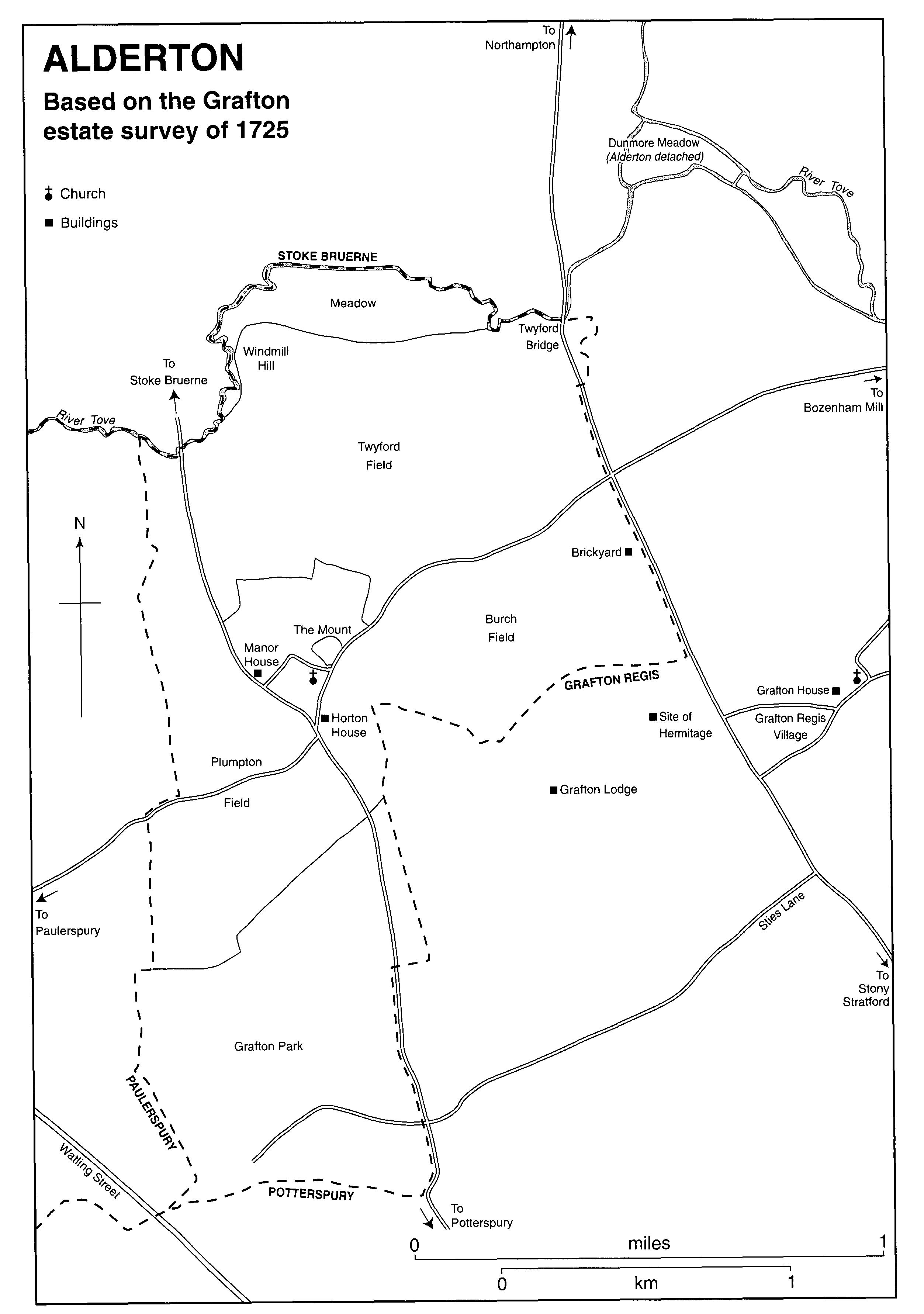
The former parish of Alderton, which was transferred entirely to Grafton Regis in 1935, (fn. 1) occupied some 878 acres to the south and west of the river Tove about nine miles south of Northampton and three miles from Towcester. The parish was separated from Stoke Bruerne on the north by the river; to the west the boundary with Paulerspury ran through fields; while to the south and east the boundary with Grafton was represented partly by an unnamed tributary of the Tove, partly by the main road from Stony Stratford to Northampton, and partly by hedges. The land of the parish rises from the river in the north, which lies about 245 ft. above sea level, to a maximum of about 350 ft. in the south. The lower areas near the river are covered by alluvial deposits and Upper Lias Clay; Oolitic Limestones and Boulder Clay are found at higher levels.
Until 1883, when the land was added to Grafton Regis, Alderton included a detached area of about 16 a., known as Dunmore Meadow, which lay alongside the Tove near the point at which the parishes of Stoke Bruerne, Ashton and Grafton meet. (fn. 2) Conversely, some 5 a. of meadow to the north of the Tove, in Stoke parish, were regarded prior to inclosure in 1821 as forming part of the adjoining common meadow of Alderton to the south of the river; and until the same date 13 a. in Grafton Regis, but close to Alderton village, belonged to the open fields of Alderton. (fn. 3) In 1721 a small area towards the south-western corner of Alderton parish formed part of Paulerspury open fields. (fn. 4) As one of the out-towns of Whittlewood, Alderton had rights of common in the forest between 4 May and 25 September and when the land was disafforested in 1861 the parish received an allotment of land in Paulerspury, near the Gullet. (fn. 5)
Domesday Book records a population of eight at Alderton in 1086. (fn. 6) In 1301 37 people were assessed to the lay subsidy there (fn. 7) and in 1524 the figure was 21. (fn. 8) A total of 27 households were assessed to the hearth tax in 1674, of which 11 were discharged through poverty. (fn. 9) By the early 18th century there were about 25 houses in the village. (fn. 10) The first census recorded 32 houses and 183 inhabitants in 1801, figures which barely changed throughout the 19th century. There was a steady decline in the first half of the 20th century, with only 56 residents in the village in 1935. (fn. 11) By November 1953, when the village took a private census for their Coronation scrapbook, the population had risen to 94, although there were still 31 houses, (fn. 12) exactly the same as in 1811. In 1977 the population had reached 110, consisting of 35 families living in as many houses. (fn. 13)
Alderton lies between the two main roads which run through Cleley hundred, Watling Street and its branch from Stony Stratford to Northampton, and the only road serving the village forms a link between them. From a junction on Watling Street on the outskirts of Paulerspury village, Pury Road runs uphill to Alderton before continuing to join the Northampton road a short distance south of Twyford Bridge, which carries the main road over the river Tove. This junction has been realigned in recent years but the original line of the lane from Alderton can still be made out near Brick Kiln Farm. This route was known as Bozenham Mill Road in the early 19th century, (fn. 14) and continued beyond the junction with the Northampton road across the fields to the mill, which stood on the left bank of the Tove just inside Hartwell parish. (fn. 15) The section beyond the Northampton road was still in use as a footpath in the late 19th century, (fn. 16) but has since disappeared, although a bridge carrying the path over the Grand Union Canal near Bozenham Mill still exists.
The parish was linked with Stoke Bruerne to the north and Grafton Park to the south by bridleways, both of which ran from junctions with the main road near the southern entrance to the village and extended for a short distance as carriage roads before continuing as field paths. (fn. 17)
Landscape And Settlement.
Roman coins, possibly from a hoard buried before A.D. 43, were found somewhere in the parish c. 1821. (fn. 18)
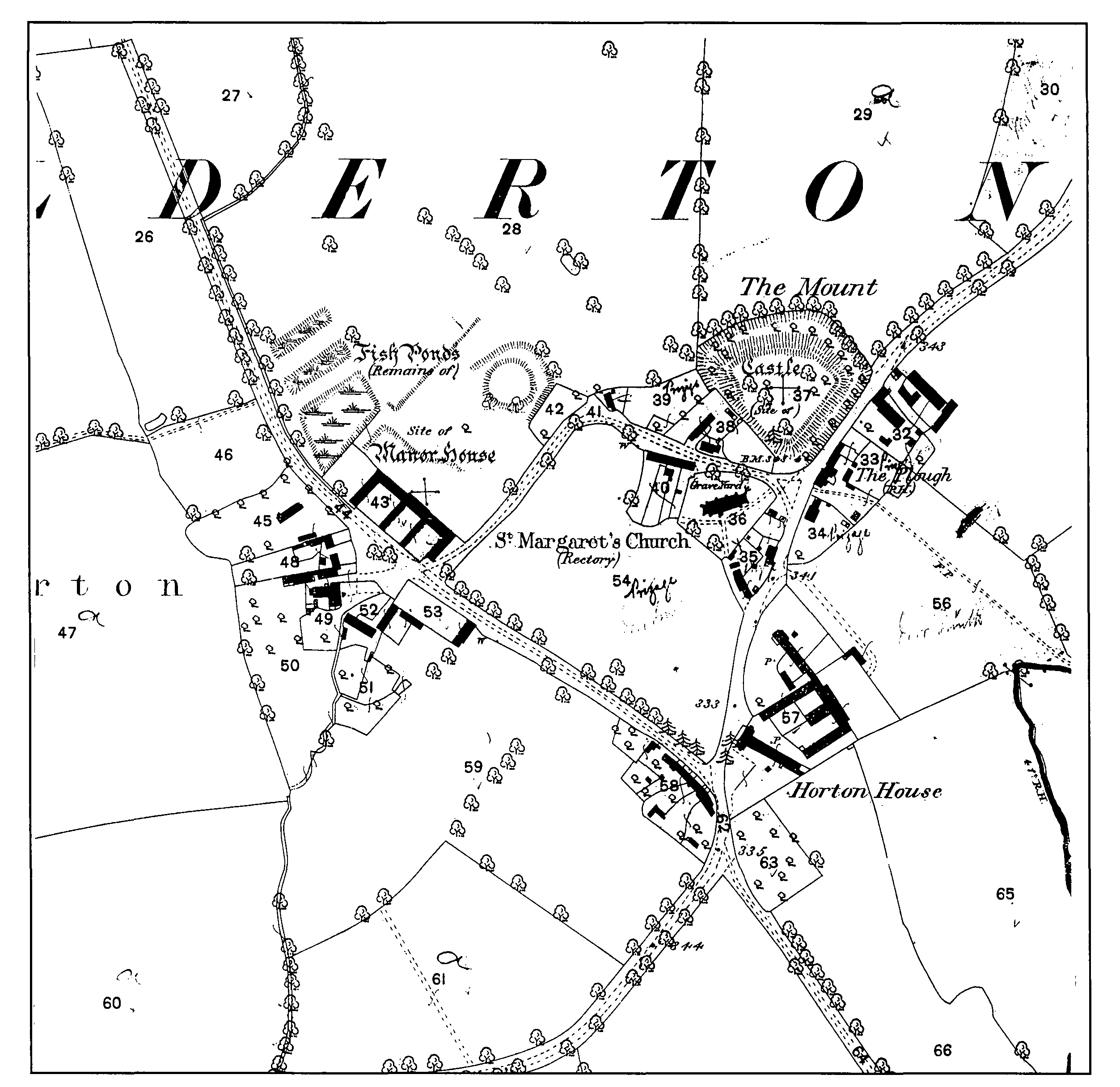
Settlement in Alderton appears always to have been confined mainly to the small nucleated village which occupies the higher ground in the centre of the parish. At the highest point in the village stand the remains of an early medieval ringwork, known as the Mount, the site of the oldest manorial buildings. (fn. 19) To the south of the Mount is the parish church and Collier and Baker's plan of 1727 (fn. 20) shows that most of the houses in the village lay close to these two features, on either the road from Paulerspury or Church Lane, which runs west from the main road between the church and the Mount before turning south to join Spring Lane, the road which runs from the village north towards Stoke Bruerne before petering out into a bridlepath. At the point at which Church Lane makes its sharp turn to the south a well-defined holloway continues westwards, marking the site of a path that had disappeared by the early 18th century.
Besides the older nucleus around the church and castle, and 20th-century additions to the built-up area, the village contains two other groups of building. One lies to the west of the north-south section of Church Lane and north of the track running towards Stoke Bruerne (here called Moor Lane), where earthworks indicate the site of a 16th-century mansion built by a Crown lessee. (fn. 21) The other is near the junction of Spring Lane, Pury Road and the lane running south through the fields towards Grafton Park, where Thomas Horton, a freeholder with an estate of about 45 a. that was later acquired by the 2nd duke of Grafton, (fn. 22) erected a substantial two-storey house in 1695. (fn. 23) After the demolition of the manor house, this became the largest property in the village and in the later 19th century, together with Manor Farm, the home of one of the Grafton Estate's two principal tenants in the parish. (fn. 24) The plan of 1727, prepared four years after the duke bought the Horton estate, marks extensive outbuildings behind the house. After these two farms were combined in 1897, the homestead at Manor Farm was abandoned, although the buildings were retained, and the tenant lived at Horton House, which confusingly then became known as 'The Manor'. (fn. 25) Across the road from the house the plan of 1727 marks a row of six cottages.
The pattern of settlement in 1821 (fn. 26) was little changed from a century earlier. A few cottages had disappeared from the northern edge of the built-up area along Bozenham Mill Road, as had a farmhouse on Moor Lane, beyond the gardens of the manor house, but otherwise the number of houses must have remained virtually the same, reflecting the absence of any marked rise or fall in population. Later in the 19th century a farmhouse and outbuildings to the south of the church were demolished but no other major changes took place until after the sale of the Grafton estate began in 1920. At this date all the houses in the village were built of local stone and thatched, although in 1953 it was noted that several had recently been re-roofed with stonecoloured tiles. (fn. 27)
The modern expansion of the village began in 1943-8, when Towcester Rural District Council built a total of eight houses in Pury Road and Church Lane. (fn. 28) During the 1950s several of the older cottages were vacated by farm labourers' families and sold to young professional couples who modernised and extended the property. (fn. 29) The first new private houses were not erected until 1965, when three detached 'chalet bungalows' were built on the site of demolished cottages on Church Lane. (fn. 30) A couple of years later the Whitlocks retired from Glebe Farm (which became a private house and was much extended by the new owners) and moved to a bungalow nearby. (fn. 31) When the Fountaines retired from Manor & Horton's Farm in 1976 their home was sold off with a small amount of land to become a private house, (fn. 32) whose new owners reinstated the more accurate name 'Horton House' in place of 'The Manor' favoured by the Fountaines. There was, however, little new building in the village until the 1980s, when sites were released on the west side of Spring Lane for two large detached houses and the old Manor Farm buildings were converted to residential use. In 1996-7 the extensive farm buildings at Horton House were made into small workshop units.
The progressive modernisation of the older houses, coupled with some new building, transformed the appearance of Alderton between the end of the Second World, when the village was described as 'tumbledown' and threatened with complete rebuilding, (fn. 33) and the 1990s, when the entire housing stock was well maintained. This change partly reflects the transformation of the community from a farming village to one favoured by professional families who worked elsewhere, but also the fact that by 1945 both the Grafton and Hesketh estates had sold off all the cottages to private owners able and willing to improve them. (fn. 34)
Building outside the village has always been very limited. The main road which forms the eastern boundary of the parish lies too far away for settlement to grow up alongside, as happened at Grafton Regis, and the earliest building there was a tollhouse erected a short distance south of Twyford Bridge, after the road was turnpiked under an Act of 1768. (fn. 35) Also from 1768 (until 1903) there was a small brickyard on the west side of the main road south of Bozenham Mill Lane. (fn. 36) After this went out of use the land was sold by the Grafton estate in 1920 (fn. 37) and the site was occupied by Brick Kiln Farm.
Until inclosure in 1821, the village was surrounded on all sides by three open fields: Twyford Field to the north, Plumpton Field to the west and south, and Burch Field to the east. (fn. 38) These names are used reasonably consistently from the late 17th century, although one early 18th-century glebe terrier refers to Windmill Field (i.e. Twyford Field) and Sandhill Field (Burch Field), as well as describing Plumpton Field as Wood Field, (fn. 39) a name which also occurs in 1354. (fn. 40) Beyond Twyford Field lay an area of common meadow alongside the river, together with a smaller area of common grazing, known as the Moor, which lay in the north-western corner of the parish, at the end of Moor Lane. By 1821 there had been a good deal of piecemeal inclosure in all three fields, although 521 a. still remained to be allotted by the commissioners.
ALDERTON
Based on the Grafton estate survey of 1725
The major area of old inclosure lay to the south of Plumpton Field, where in 1821 some 231 a. of Alderton parish formed part of the Grafton Park estate, the rest of which lay in Grafton, Potterspury and Paulerspury. (fn. 41) The Alderton section included part of the medieval Grafton Park, which was enlarged in 1532 by the addition of 76 a. from the fields of Grafton and 70 a. from Alderton, (fn. 42) and the boundary between Plumpton Field and Grafton Park shown on a map of 1721 (fn. 43) and on the inclosure award a century later must be that established after the enlargement of the park by Henry VIII. An older boundary is clearly discernible on maps from 1721 to modern times and on the ground. (fn. 44) Although inclosures had begun to be made in the park by the early 18th century, a considerable acreage remained wooded, chiefly with oak, but also ash, maple and crabtree. (fn. 45) By the 1830s, the whole Grafton Park estate, then amounting to 995 a., had long been disparked and let as farmland. (fn. 46)
Grafton Park, occupying just over a quarter of the parish after its enlargement in 1532, provided Alderton with its only woodland. Its importance in this respect is reflected in the use of the names Wood Field for the adjoining open field and Wood Lane for the track which runs south from the village, which in 1821 was specifically described as a public bridleway and private carriage road for the use of the inhabitants of Alderton to fetch wood from Grafton Park. (fn. 47) Since then most of the wood within the former park has been cleared and the land farmed in the same way as the rest of the parish.
MANORS AND OTHER ESTATES
Manor of Alderton.
In 1066 Edmar and Edwin held Alderton freely. Twenty years later the manor formed part of the extensive estates of Robert count of Mortain, the Conqueror's half-brother. (fn. 48) Robert's son and successor William forfeited the comté by rebellion in 1106, and the title later passed to Henry I's nephew Stephen. After Stephen's death in 1154 his surviving son William succeeded to the comté but died childless in 1159, when it was resumed by the Crown. In 1189 Richard I bestowed the title on his brother John, who was known as count of Mortain until he succeeded to the throne in 1199. He lost the comté with the rest of Normandy in 1204. (fn. 49)
When, in the same year, John seized the lands in England held by Normans, an extent was made of the manor of Stoke, (fn. 50) adjacent to Alderton and coupled with it (but without the name of a tenant) in the early 12th-century Northamptonshire survey. (fn. 51) Also in 1204 John assigned Grantham and Stamford (Lincs.) to William de Warenne earl of Surrey until William should recover his lands in Normandy, or until the king could make him an equivalent in exchange for them. (fn. 52) The earl appears to have acquired both Stoke and Alderton under this arrangement, since he was in possession of the two manors a few years later, when he granted them to William Brewer. (fn. 53) Thereafter the paramount lordship of Alderton descended with Stoke Bruerne. (fn. 54)
In the 1190s John Maudit appears to have been the undertenant of Alderton, since he claimed the advowson there, as did his sonsin-law in 1219-20. (fn. 55) Both Alderton and Stoke Bruerne, however, were granted by William earl of Surrey to William Brewer (d. 1226), a prominent Crown servant of the reigns of Richard I and John, who in 1210-12 was found to hold lands in Stoke. (fn. 56) At some date after 1215 William confirmed to Brewer and his heirs all the lands in his fee of Stoke, Shutlanger and Alderton, with whatever he or his predecessors had in those lands, by the service of one knight's fee. (fn. 57) Brewer was succeeded by his son, also named William, to whom Surrey made a new grant of all the land in his fee in Stoke, Shutlanger and Alderton for the service of one knight, (fn. 58) presumably shortly after the elder Brewer's death. Brewer in turn made a grant in 1227 to William de Moiun of land in Stoke to be held by the service of half a knight's fee; (fn. 59) perhaps at about the same time nine men, described as free tenants of the manor of Stoke, delivered 50 solidates of land in the township of Alderton to William at the command of the lord. (fn. 60)
The younger Brewer died without issue in 1232, leaving as coheirs his five sisters and their representatives. In 1233 Stoke (including Alderton and Shutlanger) was allotted to his third sister Margaret, (fn. 61) subject to the dower of William's widow Joan, who retained the estate until her death. (fn. 62) From 1233 Alderton passed for the most part by the same title as Stoke until both manors were annexed to the honor of Grafton at its creation in 1542. (fn. 63) An undivided third of Alderton, however (but not the corresponding portion of Stoke), was sold by Sir John Longeville in 1500 to Richard Empson. (fn. 64) Although the land in Alderton sold at the same time (fn. 65) later passed with the rest of Empson's estate to the Fermors of Easton Neston, (fn. 66) the share of the manor and advowson were retained by the Crown after Empson's execution. (fn. 67)
Alderton Village
Both Alderton and Stoke Bruerne passed with the rest of the honor to the 2nd duke of Grafton in 1706 and, although the 11th duke offered the lordship of Stoke Bruerne for sale in 1987, (fn. 68) he remained lord of the manor of Alderton in 2000.
Alderton appears to have been leased in the mid 13th century to Sir James Savage, who in 1265 in turn demised the manor and advowson to Sir John Lovell for 12 years. (fn. 69) The manor was seised by the Lord Edward during the Barons' Revolt (fn. 70) but returned, for in 1269 Sir Thomas Savage released his rights in the castle and township of Alderton, and his lands there, to the lord of the manor, Pagan de Chaworth, (fn. 71) the grandson of another Pagan, who had married Gundred, the daughter and heiress of Margaret Brewer. (fn. 72) Chaworth also secured a quitclaim from Sir John Lovell, the son of the lessee of 1265, of any interest he had in the estate, (fn. 73) although Lovell appears to have taken a new lease of the manor for 11 years from c. 1272. (fn. 74) When Pagan's brother and heir Patrick de Chaworth died in 1283 the outgoings from the manor of Alderton included 26s. 8d. and various benefits in kind due yearly to Maud la Savage; the jurors also found that the lord of Stoke ought to find reasonable food and clothing for Maud's sons Geoffrey and Robert all their days. (fn. 75)
The Manorial Buildings.
The early medieval earthwork known as the Mount consists of a roughly triangular area surrounded by a ditch up to 15 ft. deep, which is shown as filled with water in 1727. (fn. 76) The ringwork appears to have been built in the 11th century and last occupied in the 14th. (fn. 77) It was no doubt the 'castle' of Alderton which was among the premises quitclaimed by Thomas Savage to Pagan de Chaworth in 1269. (fn. 78) Musket balls from the 17th century have also been found on the site. (fn. 79) Inside the Mount there used to be a stonewalled village pound, with an entrance on its southern side. (fn. 80)
After the Mount ceased to be occupied, the manor appears to have lacked a capital messuage until after it was annexed to the honor of Grafton. A lease of the site of the manor and demesnes to Sir John Williams in 1548 included a close called 'Roundmote', which is perhaps the Mount, but not a house. (fn. 81)
Williams was succeeded as lessee of the demesnes by Edward Cornwall of Grafton Park, the younger son of Robert Cornwall of Haverhill (Suffolk), (fn. 82) to whom a new lease was granted in 1567. By this date there was a capital messuage at Alderton, described as a fair house but in great need of repair, which Cornwall agreed to carry out at his own expense. (fn. 83) In 1572 the estate was leased in reversion to Robert Stafford, serjeant porter of the household, for 21 years from 1588, the lessee undertaking to provide entertainment for the queen's steward and surveyor when he came to hold courts or survey the estate. (fn. 84)
Stafford appears to have assigned the lease to William Gorges, who in 1582 built a large new mansion on the site of the former manor house. (fn. 85) Gorges, together with Edward Langham, had already obtained, in 1580, a 21-year lease of several parcels of wood and woodland, totalling 90 a., in Potterspury, Alderton and Paulerspury. (fn. 86) Gorges died in 1589 and was buried at Alderton. (fn. 87) His widow Cicely secured a renewal of the lease in 1590 (fn. 88) and later remarried. In 1596-8 she and her new husband Edward Fust, and also her mother Eleanor Spatchford, were involved in a violent dispute concerning debts alleged to be due from William Gorges's estate. The three of them were accused of organising up to 20 men to attack the mansion at Alderton, which was described as a very strong house, new built, all of stone, although in June 1598 the mob breached the 'great walls' surrounding the 'outward court' and seized the building. (fn. 89)
The Alderton lease passed from Mrs. Fust to her only daughter and heir Frances Gorges. She married Sir Thomas Hesilrige of Noseley (Leics.), who was created a baronet in 1622 and died in 1629. (fn. 90) As well as rebuilding the mansion, William Gorges also inclosed about 9 a. around the house, which in 1627 Thomas Hesilrige was accused by other tenants of the manor of damaging. (fn. 91) It was at this house that Queen Anne was entertained for four nights in August 1605, when her husband James I stayed at Grafton Manor. (fn. 92) Three years later the king himself stayed at Alderton. (fn. 93)
In 1650 the mansion consisted of a large hall, parlour, two butteries, a kitchen, pantry, larder, dining room and several lodging rooms on the ground floor, with a long gallery and an unspecified number of chambers over, in all twelve bays of building. Outside were two gardens, a large orchard with a large moat in it, a dovecote, stables, barns and other buildings. (fn. 94)
After the death of Sir Thomas Hesilrige, the first baronet, the Alderton lease passed to his son Arthur and grandson, another Thomas, who died without male issue. The Noseley estate descended in tail male but Alderton went to Thomas's daughter Mary, who first married a kinsman, Arthur Hesilrige the son of John Hesilrige, a son of the first Sir Thomas. (fn. 95) After he died in 1670, Mary married Dr. Samuel Rolt, the son of Stephen Rolt of Thurleigh (Beds.), (fn. 96) to whom the Alderton estate thus passed. In 1700 Rolt obtained a renewal of the lease of the manor house and about 160 a. of land in Alderton. (fn. 97)
By this date the house was 'falling to decay' and was partly taken down by Rolt, although in Bridges's day enough survived to show that it had been 'a noble structure'. (fn. 98) A century later all that remained were some mullioned windows in the farm buildings on the site, (fn. 99) which in the mid 19th century were replaced with a set of new buildings. These in turn became redundant and were sold in 1984 to H.W. Mason & Sons, who converted them into two large houses and built a third, Manor Court, alongside. (fn. 100)
To the rear of these houses are earthworks indicating the site of the manor house and gardens, including the remains of a circular feature that is presumably the 'moat' of 1650. This has been interpreted as a prospect mount, although recent archaeological investigation suggests that it may be a motte later re-used as part of the garden layout. (fn. 101) If so, there evidently was a later medieval manor house at Alderton, superseding the ringwork.
On the opposite side of Moor Lane from the manor house of 1582 there was a range of stables, barns and other buildings in 1650, known as the cottage yards, (fn. 102) which were still standing in 1727. (fn. 103) The largest of these became a farmhouse known as Manor Farm in the 19th century, to which the modern buildings on the site of the manor house belonged. (fn. 104)
Other estates.
Probably sometime in the 13th century William Bond gave the hermitage at Grafton Regis an annual rent due from Ingram Cummin from 4 virgates of land in Alderton, while Ingram himself gave the rent from another virgate in the township. Hugh de England gave the rent from 5 a. of land and 5 roods of meadow in Alderton in the tenure of Robert de Sclipton. (fn. 105) The hermitage and its lands later passed to St. James's abbey, near Northampton, and in the early 17th century the former abbey estate still included a rent of 4d. issuing out of a messuage and land in Alderton. (fn. 106) Also in the 13th century Geoffrey son of Humphrey of Alderton gave St. James's abbey itself 3 a. of meadow in 'Dunnemannesmede'. (fn. 107)
In 1237 the Templars acquired land and rent in Alderton from Roger de Hawkesley and Sybil his wife. (fn. 108) The grant by Queen Mary of 1558 which attempted to re-establish the Hospitallers in England included land in Alderton which had previously belonged to the preceptory at Dingley. (fn. 109) Sewardsley nunnery, in Easton Neston, had a rent charge of 2d. on a messuage and land in Alderton. (fn. 110)
These gifts to religious houses and the survival of other conveyances relating to premises in Alderton (fn. 111) indicate that there were a number of freeholders in the parish in the Middle Ages, as does the gift of land in Alderton by nine free tenants of the manor of Stoke of land in the early 13th century. (fn. 112)
In 1500 Sir John Longeville, who then held a third of the manors of Stoke and Alderton, conveyed to Richard Empson of Easton Neston all his lands in Alderton and his share of the manor and advowson. (fn. 113) After Empson was attainted and beheaded early in Henry VIII's reign, his estates were initially granted in 1512 to William Compton, including lands in Alderton (but not the share of the manor and advowson). (fn. 114) The Alderton premises subsequently passed with the Empsons' home manor of Easton Neston to Richard Fermor, who was himself attainted in 1540 and restored to favour ten years later, when some of his lands, including those in Alderton, were returned to him. (fn. 115) The Fermors retained a small estate in the parish until inclosure in 1821, when it was conveyed to the 4th duke of Grafton in exchange for land in Paulerspury. (fn. 116)
ECONOMIC HISTORY
Medieval farming.
In 1086 the count of Mortain had two hides and half a virgate of land in demesne, on which there were three ploughs with one serf. Three villeins and three bordars had another two ploughs, making five in all, although there was said to be land for eight ploughs. The estate, valued at 40s. a year in 1066 and 50s. in 1086, also contained woodland three furlongs in length and breadth. (fn. 117) An unnamed thegn, evidently the tenant in 1066, held a hide of land of the count, valued at 10s. a year, containing land for two ploughs, on which he had one plough. (fn. 118)
The arable land of the manor was clearly divided into three open fields in the Middle Ages, although the only evidence for their organisation dates from the last century before inclosure in 1821. (fn. 119)
The manor of Alderton contained 115 a. of arable, meadow worth 12s. 8d., and pasture worth 3s. a year in 1283. Its gross value was £41 6s. 7¼d., out of which 3s. 6d. was due yearly to the king for two assarts, and 13d. and 1 lb. of pepper to the abbot of Grestain (the lord of the adjoining manor of Grafton). A sum of 26s. 8d. and quantities of wheat, barley, oats, hay, straw and broom, as well as a new furtrimmed robe, valued together at £9 10s. 4d., were also due yearly to Maud Savage. (fn. 120)
The former Longeville portion of Alderton, sold to Richard Empson in 1500, was valued after Empson's attainder at 41s. 10½d. a year, of which 34s. 8d. came from yearly rents and the balance from rents of assize. The estate included three coppices containing in all 22 acres. (fn. 121)
Farming, 1542-1706.
After the manor was annexed to the honor of Grafton in 1542 most of the estate was leased in 1548 as a single entity to Sir John Williams (later Lord Williams of Thame), then the chief office-holder in the honor, who was already tenant at will at Alderton. The lease included the site of the manor, several closes, various parcels of meadow, and 100 a. of arable. (fn. 122) Apart from outlying land belonging to the manor at Abthorpe and Foscote, which was leased separately in 1550-52, (fn. 123) only two farms in Alderton itself seem to have been leased directly by the Crown during Edward VI's reign. (fn. 124) A close that had previously been overlooked was leased to John Kirby in 1564. (fn. 125)
In 1569 farms previously leased to Williams were granted out individually for terms of 21 years. (fn. 126) As elsewhere in the honor, the leases were called in for surrender after about 10 years and new grants made, either in possession or in reversion. (fn. 127) The first leases for three lives in Alderton were granted in 1583-4 (fn. 128) and in 1605-7 several farms were leased for terms of 40 years, with increments in the rent, expressed in terms of a lamb (6s. 8d.) or a sheep (16s.). (fn. 129) Also during James I's reign the tenants of Alderton lost land to the enlargement of Grafton, Potterspury and Plumpton parks. (fn. 130) In return they were granted common rights in the King's Close, just inside Grafton parish. This arrangement led to a longrunning dispute between the farmers of the two parishes which erupted in litigation at various dates between the 1630s and 1660s. (fn. 131) In 1638 most of the Alderton estate, including the manor house and demesnes, was included in the large lease for 31 years in reversion of much of the honor granted to Thomas England and Richard Fitzhugh alias Caporne. (fn. 132)
Besides the manor house, there were seven farms in Alderton in 1650, one of which had 20 a. of arable, the others between 40 a. and 52 a. Each had a few acres of meadow and at least one close of pasture. An eighth holding consisted only of accommodation land, including 40 a. of arable. The farmhouses all had a hall, parlour and kitchen downstairs, together with service rooms, and chambers over; one of the houses was three-storeyed. All the holdings were subject to the 40-year leases granted at the beginning of the 17th century, although in some cases leases for lives made in the 1580s remained in being. The estate as a whole was let for £16 17s. 1d. a year, together with £3 2s. 11d. in chief rents; the total annual value of the manor, including the premises in Abthorpe and Foscote, was £45 17s. 11d. (fn. 133) When the earl of Arlington was granted the reversion of the honor in 1673 the manor was valued at £40 17s. 5¼d., including 17s. 1¼d. in rents of assize from free tenants and 9s. from perquisites of court, with the rest coming from a number of leases in Alderton, Foscote, Abthorpe and Towcester. (fn. 134)
Farming in the 18th and 19th centuries.
During the period in which the honor was in the hands of Queen Catherine (1665-1705), the Alderton estate continued to be leased for periods of between seven and 21 years, mostly in farms of 50 a. or less, apart from Rolt's lease. When the honor came into his hands after the queen's death, the 2nd duke of Grafton initially maintained the same policy and granted renewals to tenants who had held leases from the queen (or to their immediate descendants), which generally extended the term of the lease to a total of 21 years. (fn. 135) After the death of the duke's mother in 1723, and the appointment of commissioners to assist him in the running of the honor, (fn. 136) policy changed.
Without disrupting relationships with existing tenants, the estate first replaced the older type of lease, characterised by small rents and entry fines, with leases for shorter terms at much increased rents (but without fines), and then abandoned leases altogether for tenancies at will. As early as December 1725 the commissioners noted that one of the Alderton leases had expired and that the steward had let the premises at will for £30 a year, in place of £1 6s. 9d. which the previous lessee had been paying. (fn. 137) In 1729 they observed that most of the Alderton estate was out of lease and the land in the hands of the undertenants of the last lessees. It was agreed that the tenants should be allowed to remain until the duke's wishes were known but that in future no leases should be granted for more than three years. (fn. 138) The following year three Alderton tenants were offered leases for this period at rack rents. (fn. 139) In 1752 one of the farmers was granted a twelve-year lease, as was a Grafton Regis tenant who also had some land in Alderton, (fn. 140) but when the estate was surveyed in 1757 the other three Alderton farms (as well as the cottages) were on annual tenancies at will, (fn. 141) and no further leases were granted. When the estate was put up for sale in 1920, all the Alderton property was held on Lady Day tenancies. (fn. 142)
A second aspect of the management of the estate was the consolidation of the farms into fewer units of roughly equal size. The earliest reorganisation took place after Samuel Rolt's death in 1722, (fn. 143) when, although the manor farm remained largely intact, some land was transferred to another tenant. Besides Rolt's estate of about 160 a., there were six other farms, ranging from 20 a. to 70 a., as well as two lots of accommodation land let to freeholders, (fn. 144) implying little change since at least 1650 and probably much earlier. (fn. 145) By 1757 the number of farms had fallen to four and there was only one parcel of accommodation land, (fn. 146) which in 1775 was added to one of the farms. (fn. 147) The manor farm had 140 a. in the common fields in 1757; two other tenants each had about 110 a. and the fourth 90 a. All had some common meadow and some closes in the village, adjoining their farmhouses. (fn. 148)
In 1780 the 3rd duke's steward reorganised the common fields and allotted almost exactly the same area (97 a. or 98 a.) to each tenant, together with 11 a. or 12 a. of meadow, and secured a modest increase in rents from all four. (fn. 149) There appears to have been no thought of inclosing the common land at this date but in 1811, when the estate was surveyed after the duke's death, this was recommended. (fn. 150) Inclosure was said to be under active consideration in 1814, (fn. 151) but an Act was not obtained until 1819 (fn. 152) and the award made only in 1821. (fn. 153) Either at inclosure or shortly before, one of the four farmers gave up his holding and his land was distributed among the other three tenants. (fn. 154) The farm that disappeared was not the smallest, but the one which, in the opinion of Charles Wood in 1811, offered least scope for an increase in rent. (fn. 155) In 1830 the 481 a. owned by the 4th duke was divided into three farms of 133 a., 151 a. and 157 a., together with two small parcels of accommodation land, 3 a. of cottage property, and a couple of pieces of woodland kept in hand. (fn. 156)
When the largest of the tenants, William Slater, died in 1825, his son, also named William, took over the farm for a few years but had given up by 1844, with most of his acreage transferred to Robert Blunt, who now had 256 a., and the rest to Joseph Scrivener (217 a.). (fn. 157) Blunt died in 1849 (fn. 158) and Manor Farm passed to his son John Edward Blunt. When Scrivener died in 1858 (fn. 159) Horton's Farm was taken over by Henry Smith. (fn. 160) The younger Blunt died in 1877, (fn. 161) after which his executors, of whom Smith was one, kept the tenancy on until Smith's own death in 1896. (fn. 162) From Lady Day 1897 Horton's and Manor Farm were combined into a single unit of 481 a. and let to Robert F. Fountaine, (fn. 163) who was also farming Pury Lodge Farm in Potterspury and later had Grafton Manor Farm in Grafton Regis, making a total holding of about 1,200 a. Alderton Manor Farm was given up as a homestead, although the buildings remained in use, and the Fountaines lived at Horton House, which they renamed 'The Manor'. (fn. 164) The seven farms of the early 18th century had thus become one. Robert Fountaine was still the tenant at Manor & Horton's Farm when the 8th duke tried unsuccessfully to sell the property in 1920 and his son was there in 1939 when the property was finally sold to the 1st Lord Hesketh. (fn. 165)
The third aspect of Grafton estate administration evident in Alderton is the opportunist purchase of small freeholds, a policy urged on the 2nd duke by his commissioners in 1729. (fn. 166) By this date, the duke had in fact made what proved to be the estate's largest single acquisition in the parish. During the 17th century a family named Horton had accumulated a freehold estate of about 45 a., centred on a house near the southern entrance to the village, built by Thomas Horton in 1695. (fn. 167) In 1719 Thomas's grandson James, a Towcester scrivener, became bankrupt and his assignees established that his main asset was a reversionary interest (after the death of his mother Joyce) in the family's Alderton property. (fn. 168) Despite his mother's objections, (fn. 169) James's creditors forced the sale of the estate, (fn. 170) which in 1723 was acquired by the duke for £960 (fn. 171) with the aid of a mortgage for £400 which was not discharged until 1761; (fn. 172) the duke also undertook to pay Mrs. Horton, who died in 1731, (fn. 173) an annuity of £10. (fn. 174) Thereafter Horton House remained the home of one of the estate's farm tenants until its sale in 1939. (fn. 175)
Later acquisitions were on a smaller scale. In 1765-7 Edward Bloxham acted an intermediary for the 3rd duke in the purchase of 4 a. of common arable and meadow for £35 which had previously belonged to the Bland family; (fn. 176) and in 1779 Charles Heath of Wakefield Lawn did likewise when the duke paid £160 for two cottages in the village (one of which by 1817 was the Plough Inn) and a small amount of land, bought from John and Richard Elmes. (fn. 177) In 1814 two other cottages, one newly built, plus 4 a. of old inclosure and 21 a. of common arable, meadow and pasture, were advertised for sale. (fn. 178) The vendor was George Haynes, who in 1818 was said by the duke's agent to be asking £110, but would accept £95, if not £90. (fn. 179) The duke duly bought the property. (fn. 180)
When Alderton was inclosed in 1821, at much the same date as Paulerspury immediately to the west, Grafton and the 3rd earl of Pomfret exchanged their holdings in the two parishes so as to consolidate their respective estates. The duke acquired 39 a. in Alderton, previously part of Plumpton Field, which Pomfret had bought only two years before. (fn. 181) Finally, in 1838 the Grafton estate bought one of the two remaining small freeholds in Alderton, a farmhouse and 23 a. of land belonging to James Hill, (fn. 182) which was added to the Horton House farm; (fn. 183) and in 1878 acquired the redundant tollhouse on the main Northampton road near Twyford Bridge for £15, its previous owners, the Hardingstone and Old Stratford turnpike trust, having been wound up the previous year. (fn. 184)
Apart from the disappearance of the Pomfret estate in Alderton, the inclosure of 521 a. of common arable and meadow in 1821 did not greatly affect the pattern of landownership, either at the time or later, since by this date there were only two small freeholders left in the parish. (fn. 185) Similarly, the scope for radical change on the Grafton estate was limited, since the duke's 481 a. was already divided into only four farms, and the Alderton portion (some 231 a.) of the Mordaunts' Grafton Park estate (totalling in all 995 a.) in the south of the parish was already fully inclosed. (fn. 186) The major change affected the glebe, which was increased under the award from 28 a. of land in the common fields, plus 14 a. of old inclosures, to an estate of 128 a. to compensate the rector for the loss of most of his income from tithes. (fn. 187) The Act empowered the rector to lease his glebe and in 1823 Benedict Roper took a 21-year lease from 1819 of 81 a. of newly inclosed land to the south of Bozenham Mill Road, part of the former Burch Field, plus 2 a. of old inclosures, at a rent of £134. (fn. 188) In 1882-3 a later rector took out a loan of £137 over 25 years to improve Glebe Farm, spending part of the money on drainage pipes made at the brick and tile works in the parish. (fn. 189)
When the parish was surveyed in 1727, the annual value of the 2nd duke's 559 a. was £330, with common-field land valued at 9s. an acre. This included an allowance of 8d. an acre for the privilege of grazing one cow on the Moor for every 6 a. in the common fields, and a further 4d. an acre for the custom by which, for every 10 a. of field land he held, a tenant was entitled to an acre of 'sward ground', land allotted each year in the fields sown with corn from which the farmer could usually obtain a ton of hay per acre. (fn. 190) The same figure of 9s. was used to value the common-field land in 1757, when inclosed ground was rated at between 12s. and 21s. an acre. (fn. 191) The four farms were then paying between £56 10s. and £70 a year, which, when combined with the rent from the accommodation land let with Joseph Smith's farm in Grafton and the cottages in the village, produced £295 from the parish as a whole. (fn. 192) Modest increases when farms changed hands, and when Joseph Smith's land was added to Richard Oliver's farm in 1775, lifted this to £306 immediately before Thomas Bedford's reorganisation of 1780. (fn. 193)
The changes of 1780 added about £20 to the farm rental. (fn. 194) This was probably less than might have been achieved had the 3rd duke not held to his invariable practice of never increasing an existing tenant's rent (unless he took additional land) and so continued to let the common-field land at 9s. an acre, although he noted that new tenants would pay 10s., which it was well worth. (fn. 195) The first opportunity to apply this rule did not arise until John Franklin's death in 1807, when his brother-in-law William Burnill was allowed to take over the farm, but at £80 a year, instead of the £60 10s. at which Franklin's rent had remained since 1780. (fn. 196)
When Charles Wood surveyed the estate in 1811, he suggested that a large increase in income could be achieved from the four farms, especially if the parish was inclosed. Instead of the existing rental of £348, Wood valued the estate at £635 10s., an increase of 82 per cent. In assessing the four farms individually, he proposed an increase of only 50 per cent in William Burnill's rent, but felt that around 90 per cent was possible in the case of the other three holdings, whose rents had remained unchanged since 1780. (fn. 197)
Inclosure followed ten years after Wood's report, by which time Burnill's farm had disapeared, which helped to lift the post-inclosure income even higher than Wood's figure. The three remaining farms were let for £756 in the early 1820s, (fn. 198) 115 per cent more than in 1809, (fn. 199) the last year before inclosure for which a rental survives, or 19 per cent more than Wood's valuation. In reality, this figure was not being achieved, since heavy arrears built up after 1815. In 1821, when the steward considered what allowances should be made to tenants because of the depressed state of farming, Edward Blunt was £115 in arrears on a rent of £180 and Joseph Scrivener owed £219 on a figure of £276. These were open-field rents and new inclosure rents were due to take effect from Michaelmas that year. In view of the arrears, it was felt inadvisable to make any reduction in either, but to allow 20 per cent rebate if the tenants were able to pay the arrears and meet the full rent in future. If the arrears were not paid, only 10 per cent would be allowed, the same figure as that offered to William Slater, who owed no arrears. Both Blunt and Scrivener were regarded as good tenants, whom the estate wished to encourage and retain. (fn. 200) Despite these allowances, the arrears at Alderton had not been cleared by 1825. (fn. 201)
By the 1840s, when Alderton was being farmed in only two holdings, Joseph Scrivener and Robert Blunt were paying £720 between them and the parish as a whole (including the cottages and some small occupiers) was producing £741 a year. (fn. 202) The estate was unable to proceed far beyond this point, and in 1881 the two Alderton tenants (Henry Smith and J.E. Blunt) were paying £770. In 1882-3 the estate made a general reduction of 25 per cent in farm rents, which lowered the rent of Manor Farm to £322 and Horton's to £271, (fn. 203) and in 1887-8 there was a further abatement of 10 per cent on the reduced rent, so that the two farms now paid £534. When Robert Fountaine agreed to take both in 1897, the rent was fixed at £473 15s., (fn. 204) at which it remained until the property was sold in 1939, (fn. 205) despite a claim by the agent at the time of the 1920 sale (when the rent was described as 'moderate') (fn. 206) that it was under-let. When the farm failed to sell on that occasion, the agent suggested raising the rent to £600 (25s. an acre), pointing to the rent achieved for the equivalent acreage prior to 1880, (fn. 207) but the idea was not acted on.
Trades and Crafts.
There was little non-agricultural employment in Alderton, either during the 19th century or before. A smithy at one of the cottages on Church Lane, near the Mount, closed down a few years before the First World War, although the house continued to be occupied. (fn. 208) Another house near the Mount, bought by the Grafton estate from John Elmes in 1779, (fn. 209) had by the early 19th century become the Plough Inn, (fn. 210) which remained Alderton's only licensed premises until its closure in 1958. (fn. 211)
Apart from a stray reference to Robert the miller of Alderton in 1229, (fn. 212) there is no evidence for a water-mill in the parish; the mill on the Tove near Twyford bridge seems to have been on the Stoke Bruerne side of the river. (fn. 213) Certainly from the mid 16th century, the farmers of Alderton ground their corn at Bozenham mill in Hartwell. (fn. 214) To the north of the village, near the Tove and east of the path to Stoke Bruerne, a parcel of land was known from at least 1685 as Windmill Leys. (fn. 215) Nothing is known of the mill which evidently stood here, which is not marked on the map of 1727, (fn. 216) although in 1953 an elderly resident claimed to be able to remember a 'special four-wheeled wagon' used to take corn to be ground there. (fn. 217) The indistinct circular feature tentatively identified from air photographs as a possible prehistoric ring ditch (fn. 218) may in fact be the site of a mill. (fn. 219)
A ubiquitous by-employment for women in Alderton, as elsewhere in the district, was pillow lacemaking. The craft gradually declined after 1900 and in 1953 there were only two practitioners in the village. (fn. 220) In 1711 John Elmes of Alderton was described as a 'laceman'. (fn. 221)
There was a single shop in the village from the mid 19th century until the First World War, (fn. 222) but no post office, although it did acquire a letter box, installed in the garden wall of Horton House. (fn. 223)
Two generations of the Jelley family had a carrying business at Alderton between the 1850s (if not earlier) and about 1910. They went to Northampton on Wednesdays and Saturdays, Towcester on Tuesdays and Stony Stratford and Wolverton on Fridays. (fn. 224) After the younger Jelley retired the service was continued by William Adams from Paulerspury until the late 1920s. (fn. 225) Alderton acquired a bus service as early as 1919 when Leonard Edwards, also of Paulerspury, bought a Daimler chassis with solid tyres and a four-cylinder sleeve valve engine, which had originally been used as a London bus and then as a lorry by the Navy during the war. The village carpenter built a new bus body with 26 seats. The bus started from Paulerspury and ran through Alderton to Northampton. Edwards retired in 1952, when the route was taken over by Basford's Coaches. (fn. 226)
Potash making and the Brick-Works.
Potash making appears to have been carried on at a kiln belonging to a pair of cottages in the village for much of the 18th century, possibly from shortly after the purchase of the premises by Daniel Powell of Paulerspury, 'ashman', in 1727. (fn. 227) Powell, said to be late of Alderton but then living at Moor End, near Yardley Gobion, retired in 1762, conveying the cottages and kiln to his two sons-in-law, Robert Bodaly of Greens Norton and Daniel Carr of Moor End; all three described themselves as 'potashmen'. (fn. 228) Two years later the two cottages were divided, Robert Bodaly retaining the one with the kiln, (fn. 229) which in 1765 he transferred to Daniel Bodaly of Alderton, a mason rather than potashman. (fn. 230) In 1774 Daniel's widow sold the property, (fn. 231) which changed hands several times before it was acquired by the 4th duke of Grafton in 1818. (fn. 232) The kiln continued to be included in descriptions of the premises up to 1800, (fn. 233) although there is no evidence that it was still in use, and when John Roper recommended the purchase to the duke's attorney in 1818 he made no reference to it. (fn. 234)
Daniel Bodaly may have given up potash making as early as 1768, when he took up a tenancy of 1¼ a. of Alderton common field near the junction of Bozenham Mill Lane and the Northampton road at 17s. 6d. a year, on which he was to build a brick kiln. (fn. 235) A year later Richard Carvel (or Carville) took over the premises, (fn. 236) initially at the same rent, (fn. 237) but from 1772 the figure was raised to £2 10s., (fn. 238) perhaps because the kiln was then in use. From 1779 the business was in the hands of John Carville and William Clare, (fn. 239) whose rent was raised to £5 from 1786. (fn. 240) John Ratlidge (or Ratledge) replaced Carville and Clare five years later (fn. 241) and was still paying £5 rent in 1808, (fn. 242) although there is no explicit reference to a kiln towards the end of that period.
By 1821 John Clarke Roper, the son of the Grafton steward, was renting a field named Brick Kiln Close. (fn. 243) The kiln and yard were part of Roper's holding in Alderton in 1830, (fn. 244) when he was supplying bricks and tiles to the estate. (fn. 245) It is not clear whether Roper was renting the kiln from the estate or operating it on the duke's account. The latter is perhaps more likely since in 1832 (after the estate had paid Roper for all the ware at the kiln, (fn. 246) presumably when he left) William Horner was producing common bricks, paving bricks, squares, ridge tiles, pantiles, plain tiles and drainage tiles at Alderton, as well as selling lime. Some of the goods went to a range of local customers but much of the output was supplied to the estate, suggesting that Horner was the manager, rather than a tenant. (fn. 247)
By the early 1840s the works was in the hands of Thomas and William Foxley, who made large quantities of bricks for the new farm at Shutlanger Grove, both at Alderton and at a temporary kiln at Shutlanger itself. (fn. 248) Thomas Foxley was renting the yard and 5 a. of land for £6 5s. a year, (fn. 249) a figure which had risen to £10 by the 1870s. (fn. 250) In the 1880s the firm was trading as Thomas Foxley & Sons of Mapledurham Mills (Oxon.) and Grafton Regis Brickworks (the site was slightly closer to Grafton, but in Alderton parish). (fn. 251) Thomas B. Foxley succeeded his father as tenant in 1881 and retained the works and an adjoining cottage until 1903, when it was closed and the land laid down to pasture. (fn. 252) The younger Foxley, whose main centre of operations was Little Lawford Mills (Warws.), continued to pay £10 rent until 1892, when it was doubled for the last ten years of his tenancy. (fn. 253)
The works consisted of a kiln and other buildings on the west side of Northampton Road immediately south of Bozenham Mill Lane, with a clay pit further south. (fn. 254) The buildings survived to be photographed in the 1920s, (fn. 255) but had all disappeared by 1953. (fn. 256) A smallholding, known as Brick Kiln Farm, was later established on the site. (fn. 257)
Farming and Village Life in the 20th Century.
The first indication that a traditional way of life was shortly to change, in Alderton as elsewhere, came with the outbreak of war in 1914, when all the men eligible for military service held a meeting and decided to join up together as soon as the harvest was in. They attended a special service at the church, with their mothers, and were photographed as a group before going off to Northampton to volunteer. Fifteen men from Alderton joined the Army, of whom two were killed. At the end of the war a joint celebration was held at Grafton Lodge, then the home of J.J. Martin, by the villagers of Grafton Regis and Alderton. (fn. 258)
Alderton was not included in the Grafton sales of 1913 and 1919, but in May 1920 a list was drawn up of property which was to be offered first to the tenants and then, if not sold privately, put up for auction. Besides Horton's & Manor Farm, this included the Plough Inn, 17 cottages and the former brickyard and allotments on Northampton Road. A reserve of £12,000 (27 years' purchase) was placed on the farm, £200 for the pub (21 years), £350 for the brickyard and adjoining land (23 years) and £850 (17 years) for the cottages, (fn. 259) which were divided into nine lots. (fn. 260) By September the licensee of the Plough had bought both the pub and the old brickyard for £400 and five of the cottages had been sold for £550, against reserves totalling £830. (fn. 261) This left seven Alderton lots to be included in the auction in December, when four (all cottages or gardens) were sold for £397 10s., compared with reserves of £295. Three went for £60 or less but one cottage, let at only £6 10s. a year, made £300, 50 per cent over its reserve. (fn. 262)
William Paterson, the duke's agent, refused to be despondent at the disappointing outcome of the sale. In particular he remained optimistic that he could find a private buyer for Fountaine's farm, the largest single holding anywhere on the estate included in the auction. He was also adamant that it should not be sold for less than £11,500, the reserve eventually settled on, insisting that it was under-priced at this figure, and actually turned down an offer of £11,000. (fn. 263) As a result, Horton's & Manor Farm remained in the hands of the Grafton estate until it was sold by auction (together with the Mount) in 1939, (fn. 264) and thus the impact of the break-up of the estate on Alderton was less than in those parishes where hundreds of acres changed hands in 1919-20. Even the effect of the 1939 sale was less than might have been the case, since the purchaser was Lord Hesketh of Easton Neston, rather than the tenant. (fn. 265)
The other major change in landownership in Alderton in the inter-war years came in the 1920s when Thomas Wood acquired the freehold of Glebe Farm (110 a.) from the church, which in 1943 he let to R. Whitlock from Grimscote. (fn. 266)
Alderton was affected only indirectly by the Second World War. Two air raid wardens were appointed and a first aid post established at the Manor House, with Mrs. Fountaine in charge; she was also the local W.V.S. representative. Parcels were sent to the one local man serving in the Army and to the company of H.M.S. Grafton. One stray bomb fell on the parish, which left no casualties and no damage beyond a huge crater. Some of the men not called up joined a home guard platoon which trained at the old school in Grafton. The R.A.F. built a bombing range, used for the final stages of aircrew training, which extended into Alderton (where there was an observation tower in Moor Meadow), Paulerspury and Shutlanger. This was manned by two sergeants and six men attached to the aerodrome at Silverstone, some of whom were billeted in Alderton. On one occasion a stick of bombs was dropped right through the village by accident. (fn. 267)
In 1939 the village was warned to expect evacuee children but none arrived, possibly because the nearest school was two miles way. One or two London families took houses in Alderton to escape the Blitz but none stayed after the war. When a land mine was dropped at Pury End in Paulerspury and damaged some houses, (fn. 268) one family moved to an empty cottage in Spring Lane and were later given a council house in Pury Road. At the end of the war, the church bells were rung on VE day for the first time since 1939 and a tea party was immediately organised for the children. For VJ day more elaborate celebrations were arranged, including a film show with power supplied by car batteries. (fn. 269)
The war-time shortage of petrol meant that the pony and trap reappeared as a means of transport and also prolonged the use of farm horses, which continued to be employed after the war for carting manure, roots and winter fodder, for which they were more economical than tractors and did less damage to the land. In 1953 Glebe Farm still had one horse and Manor Farm four; (fn. 270) two years later, when the 2nd Lord Hesketh, the principal landowner in the parish, died, Jim Fountaine provided the horse-drawn wagon which bore his coffin to the church at Easton Neston. (fn. 271)
Mechanisation, however, remained the most prominent feature of farming during these years. There were five tractors in the village in 1953, (fn. 272) with diesel-engined Fordson and David Brown machines, costing about £600 each, replacing old petrol and paraffin types. (fn. 273) A combine harvester was first used on Fountaine's farm in 1955, (fn. 274) an innovation which, combined with the erection of three large dutch barns, saved much time and labour, as well as wastage from the weather, in thatching corn stacks. (fn. 275) By 1963 the farm had installed mechanical drying equipment and storage silos to improve the handling of the corn crop. (fn. 276)
In the early 1950s the Fountaines employed seven men to farm just under 500 a. at the Manor, while the Whitlocks, with 110 a. at Glebe Farm, had three; in both cases much of the seasonal work was contracted out. During the war the farms had drawn labour from the Pioneer Corps and the Women's Land Army and had also employed gipsies and Austrian and German prisoners. (fn. 277)
The gradual decline of farming as the main employer in the parish is reflected in the census taken for Alderton's Coronation scrapbook in 1953, which revealed that of a population of 94, only 13 were engaged in agriculture, as compared with 15 in the professions or industry and three in the public service. The remainder included 32 women not employed outside the home, five men away on National Service, five people who described themselves as retired, and 21 children of school age or below. (fn. 278) Five years later, the population had dropped to 71 (57 adults and 14 children), of whom only 10 were engaged in farming. (fn. 279)
The newcomers, who did not work locally, came initially to live in the older cottages sold off by the Grafton or Hesketh estates. These they proceeded to modernise and extend, while the farm labourers who had previously occupied them were happy to secure tenancies of the council houses in Pury Road and Church Lane. Thus in 1957 a cottage named 'The Nook' changed hands after being greatly enlarged by its previous owners, a cardboard box manufacturer from Northampton and his wife. (fn. 280) Nine years later the same house, which had been bought from the Grafton estate for £60 in 1920, was sold for £7,000. (fn. 281)
Equally striking was the fate of the 'Round House', originally three cottages, which were sold by the Grafton estate shortly before the Second World War to a house-breaker for £18. Instead of demolishing them, he made an opportunist sale for £45 and the purchaser waited until the tenants had moved to the council houses in Church Lane before converting the row into a single property which was sold for £1,000. (fn. 282) In 1955 the house made £1,850 at auction. (fn. 283) Similarly, Spring Lane Cottages, opposite Horton House, were sold by Lord Hesketh in 1949 (having been bought as part of the Horton's & Manor Farm property ten years before) and modernised by the new owner. (fn. 284)
More radical change came in 1965, when the dormer bungalows on Church Lane were built, since the first two were both bought by couples who commuted some distance to work: Bletchley in one case and London in the other. (fn. 285) In 1964 Tom Wood, the owner of Glebe Farm, died, (fn. 286) and shortly afterwards the Whitlocks gave up farming there, moving to a bungalow they had had built nearby. (fn. 287) In 1967 the old farmhouse, now called Glebe House, was extensively modernised by a Northampton solicitor and his wife. (fn. 288) Alderton's new status as a 'much sought after village' in which 'property of this calibre' rarely became available was stressed when one of the bungalows on Church Lane came on the market at £7,000 in 1969. (fn. 289) One consequence of this influx was an increase in the number of children. In 1965 Mrs. Fountaine, after hosting her annual Christmas party at the Manor, reflected that thirty years before there had only been five children out of a population of 56, whereas there were now 19 out of a total of 80. (fn. 290)
The increase in population failed to prevent the closure in 1958 (by Phipps Brewery of Northampton, who had bought the house some years earlier) of the Plough, which joined the list of older property to be modernised and sold to incomers. This left the village with no public building (except the church and chapel), since it had never had a school or hall. (fn. 291) On the other hand, the effect on village life appears to have been slight: in 1946 it was said that the pub rarely saw more than four or five drinkers in an evening and that when coach trips had tried calling, the locals had complained about the noise. (fn. 292) It was also observed that by 1958 many of the houses in the village were more comfortable than in the past and 16 of them (about half the total) had television sets. (fn. 293)
With the loss of the Plough, the only commercial activity in the village in the 1960s (apart from farming) was an antique shop run from 'The Haven' by Mr. and Mrs. J. G. Merry, who moved to Alderton in 1960 and established the business the following year; it was still there in 1967. (fn. 294) Another change was the end of deliveries by a baker in Stoke Bruerne in 1956, leaving the village dependent on steam-made bread from Northampton. In the more distant past the village had been served by bakers from Paulerspury. (fn. 295) The closure of Alderton's nearest railway station, at Roade, in 1964 was not seen as a great loss. (fn. 296)
After the Whitlocks left Glebe Farm, Jim and Vera Fountaine continued to farm at the Manor until they retired in 1976 and moved to Pattishall, ending a connection with the village which extended over ninety years. At this date, there were 35 families in Alderton. Of the working population, 10 were still employed in agriculture (the same figure as 20 years before) and 13 in industry or the professions (including seven connected with education). There were still only five retired people in the village and 14 children under seven. Ten families living in Alderton in 1953 were still there, five in the same houses. (fn. 297)
The land previously let with the Manor was taken in hand by Hesketh Estates and farmed by them until it was sold in the early 1990s. In 2000 all the land in Alderton, together with a considerable acreage in adjoining parishes, was being farmed from Pury Hill Farm in Paulerspury parish. (fn. 298) The Manor House itself was sold with an extensive range of outbuildings but no land. (fn. 299) A new owner reinstated the more accurate name 'Horton House' and converted the outbuildings into workshop units. By contrast, the buildings at Manor Farm on Spring Lane were converted into private residences. This change, combined with the construction of new houses nearby, continued the process begun in the 1950s by which Alderton was transformed from a village whose residents were mostly employed on local farms into a dormitory community for professional people who worked elsewhere.
Parallel with this shift in occupational structure came changes in its social organisation. In a parish with no resident landowner, the tenant farmers would always have formed something a local élite, but after 1897 the position altered when all the land belonging to the Grafton Estate was let to a single family, who inevitably emerged as the leading figures in the community, especially after their tenancy extended into a second generation. From the 1930s until their retirement in 1976 Jim and Vera Fountaine were the central figures around which life in Alderton revolved, and were instrumental in maintaining a strong sense of community until the end of this period, despite the changes after the Second World War. (fn. 300) Neither appears to have been reluctant to take on such a role, as their decision to rename their home 'The Manor' suggests. Jim Fountaine was not only the main employer in the parish but also a local councillor for over thirty years; (fn. 301) his wife ran most of the voluntary organisations and chronicled village life; (fn. 302) and both were active church members.
Besides the events organised to mark the end of the two World Wars, Alderton's strong sense of community is also apparent in its celebration of the Coronations of 1937 (fn. 303) and 1953. The second of these included a church service at which one of the lessons was read by the leading Nonconformist in the parish and a mid-day meal at which the entire village sat down together, as well as tea and a film-show in the evening. (fn. 304) The Fountaines took the lead in these arrangements, not least by providing a barn large enough to seat over 70 people and mutton from their flock to feed them, but another resident, interviewed for a radio programme a month beforehand, stressed how everyone in the village played their part. All the planning, however, took place at the Manor, since it was the only house with enough room for large meetings. (fn. 305)
This sense of community lasted at least until the Fountaines left. Opening a fete at the Manor House in 1965, a descendant of the Blunt family, who had farmed there in the 19th century, described Alderton as 'unique in its serenity . . . a village which had never seemed to change'; (fn. 306) two years later Jim Fountaine stressed what a happy and friendly little community Alderton remained; and another resident felt that the village was one large family. (fn. 307) There there was a regular cycle of children's Christmas parties and summer garden parties at the Manor, annual coach outings for the Mothers' Union, and fund-raising activities for the church. (fn. 308) In 1972 a two-day event raised most of the cost of replacing the church heating system, when over a thousand visitors came to Alderton to see an exhibition of byegones in the church and have tea at the Manor. (fn. 309) Four years later a committee was formed to arrange events to mark the Silver Jubilee of 1977, as had been done in 1953. On this occasion it was decided to plant trees alongside the approach roads to the village to replace those lost through Dutch elm disease, and to erect a suitably inscribed noticeboard. Mrs. Fountaine also wrote a short booklet on Alderton, updating the account she produced in 1953, which effectively marked the end of her long involvement in village life. (fn. 310)
LOCAL GOVERNMENT
The Manor Court.
In the years following the creation of the honor of Grafton in 1542, a single court was held for Alderton, Shutlanger and Stoke Bruerne, presumably because the three townships had had a common manorial history since the 13th century. (fn. 311) Separate constables and other officials were appointed for each and orders made for the management of the common fields, repairs to buildings and other routine matters. (fn. 312)
By the early 18th century Alderton was regarded as one of the principal manors within the honor and a court was held twice at year at what remained of the Manor House after Samuel Rolt had partly demolished it. (fn. 313) Stoke and Shutlanger had their own court in this period (fn. 314) but tenants from Abthorpe and Foscote attended the Alderton court throughout the 18th century. As on most of the estate, there were no copyhold tenements in Alderton, but conveyances of freeholds were reported to the court, which nominated or appointed a constable, headborough, hayward and field tellers, and regulated farming (fn. 315) Most of the work of the court would have disappeared with inclosure in 1821, and by the 1830s the Alderton court had been merged with that held at Grafton Regis. (fn. 316)
The Parish.
Nothing survives to establish when the nomination of the Alderton constable passed from the manor court to the vestry, nor to shed any light on the other work of the vestry, either in the 19th century or earlier.
Alderton was far too small to have a parish council under the 1894 Local Government Act but the village appears to have received the idea of a parish meeting with some enthusiasm, since the first such occasion, held at the Manor House in December 1894, attracted an attendance of 23, which must have included a representative of nearly every house in the village. The only business was the election of a chairman, Henry Smith, who answered questions about the new Act. (fn. 317) The following March the chairman, rector and three other electors formed a rather smaller gathering at which Smith and John Jelley were appointed overseers, an office which Jelley combined with that of constable. (fn. 318) The two men secured reappointment twelve months later. (fn. 319)
After this, the Fountaines took charge of local government in Alderton, as they did other aspects of village life. Robert Fountaine was elected chairman of the parish meeting and constable in 1897, retaining both offices until 1922, when his son Jim succeeded him as constable. Jim Fountaine took over as chairman in 1923, but for one year only, since another member of the family was appointed in 1924. Robert Fountaine and John Jelley remained overseers until 1915, when Jelley was replaced by Joel Foster, the licensee of the Plough. (fn. 320) The last parish meeting was held in 1926, (fn. 321) when the abolition of the parish as a rating unit was presumably held to render the institution redundant. Alderton itself disappeared as a civil parish in 1935, when it was combined with Grafton Regis. (fn. 322) The enlarged parish remained too small to have an elected council, although a parish meeting continued to serve both communities. (fn. 323)
Robert Fountaine was also the guardian and rural district councillor for Alderton from 1896 until 1922, (fn. 324) although in 1919 his attendance record was so poor that he only escaped removal after pleading that the war-time shortage of farm labour had made it impossible for him to get to meetings. (fn. 325) Jim Fountaine succeeded his father in 1922, when he was said to be the youngest elected member of any R.D.C. in England. He continued to represent Alderton at meetings of Potterspury R.D.C. until 1935, when he secured election for Alderton & Grafton Regis on the enlarged Towcester R.D.C., which included most of the parishes making up the old Potterspury rural district. (fn. 326) He retired in 1956 and was replaced by another Alderton resident, (fn. 327) rather than a representative from Grafton, which was the larger of the two villages.
At no time during the forty years in which Potterspury R.D.C. was responsible for most local services in Alderton did the village bulk large in its work. In 1897 the supply of wellwater in the parish was satisfactory and the open ditches into which waste water was emptied were only slightly foul. (fn. 328) In 1910 Robert Fountaine, presumably impressed by the growth of motor traffic, drew attention to the dangerous corner at the junction of Bozenham Mill Lane and Northampton Road, but no action was taken. (fn. 329) Five years later a house-to-house survey revealed one cottage unfit for habitation. The Grafton agent, who was then a member of the council, undertook to see what could be done. (fn. 330) What was probably the same house, on which a closing order was later served, was reported to have been demolished six years later. (fn. 331)
Alderton was not among the parishes in which the Potterspury council built houses after the First World War and the first in the village were a pair of 'Hudson Houses' erected in Church Lane by Towcester R.D.C. in 1943- 4, as part of an emergency programme to rehouse farm workers. (fn. 332) Their completion was an occasion of sufficient moment for Lord Henley to be asked to perform the opening ceremony. (fn. 333) Three years later the council announced plans to rebuild the entire village, replacing all the existing 32 houses, many of which were condemned, although still occupied. (fn. 334) In reality, new building proceeded more slowly. In 1947 the local authority erected two pairs of 'temporary' Airey houses (which were still occupied in 2000) in Pury Road, followed the next year by two pairs of permanent brick-built houses alongside. (fn. 335)
Mains electricity reached Alderton in September 1952, (fn. 336) and piped water four years later, although by that date most houses had a pumped supply and only a few cottages were still dependent on fetching water in buckets. (fn. 337) In 1967 Jim Fountaine suggested that the major remaining deficiency was a main sewer (fn. 338) and in 1971 Towcester R.D.C. expressed the hope that Alderton and Grafton would have a system installed within a couple of years. In the event both villages had to wait much longer. (fn. 339) A telephone kiosk was erected in Spring Lane in 1958, at which date there were ten private lines in the village. (fn. 340)
CHURCH
Advowson.
In 1196-8 John Maudit, who seems to have been the count of Mortain's undertenant in Alderton, was in dispute first with Matthew de Clere and then Gerard de Mauquency, the lord of Stoke Bruerne, concerning his claim to the advowson of Alderton. (fn. 341) Further litigation arose in 1219-20, when William Brewer, the undertenant of both Stoke and Alderton, (fn. 342) presented Richard de Roffe to the church of Stoke, whom the bishop instituted, reserving the question of whether the 'chapel' of Alderton belonged to Stoke or whether Thomas Savage and Robert Morin, who had married the daughters of John Maudit, had the patronage. (fn. 343) Thomas, Robert and a third son-in-law, Robert de la Legh, accused Richard of unjustly preventing them from presenting to the church of Alderton, despite the earlier decision that the advowson did not belong to the lord of Stoke Bruerne, as the parson claimed. Judgment was given in the king's court against Richard (fn. 344) but the decision was appealed to the papal court, which threatened to excommunicate the three knights. (fn. 345) Perhaps to avoid this, they returned to the lay court to pursue William Brewer. (fn. 346)
The descendants of John Maudit appear to have had no further interest in the advowson, which thereafter descended with the lordship and thus passed to the Crown in 1542. (fn. 347) When the honor of Grafton was granted out in 1673 the advowson was reserved (fn. 348) and in 1774 Alderton was united with the adjoining Crown living of Grafton Regis. (fn. 349) In 1953 the rectory of Grafton Regis with Alderton was united with Stoke Bruerne and that living itself later united with Blisworth. In 2000 patronage was shared between Brasenose College, Oxford, and the Martyrs' Memorial and Church of England Trust, who had two turns in three (for Stoke Bruerne and Blisworth), and the Lord Chancellor, who had the third, for Grafton and Alderton. (fn. 350)
Income and Property.
Alderton was omitted from the taxation of 1254 and in 1291 was valued at £2 13s. 4d. (fn. 351) It was worth £12 3s. in 1535 (fn. 352) and in 1655 was valued at £70. (fn. 353) After 1774 figures for the income of the rectory of Grafton Regis included Alderton. (fn. 354)
Alderton glebe consisted of about 28 a. in the common fields before inclosure. (fn. 355) The tithe income was made up of three moduses in the early 18th century, one of £4 paid by Samuel Rolt as lessee of the manor house and demesnes, one of 38s. 3¾d. from the owners of the Potterspury Park estate, and one of 38s 3¼d. payable by the dukes of Grafton. (fn. 356) The last was granted by Henry VIII in 1541 in compensation for the loss of tithes from land in Alderton added to Grafton Park when it was enlarged. (fn. 357) The modus of £4 ceased to be paid when Rolt's tenancy of the manor house ended. (fn. 358)
At inclosure in 1821 the rector received 28 a. in lieu of glebe and 86 a. in lieu of tithes. The living also had 12 a. of old inclosure in Grafton and a couple of closes in Alderton. (fn. 359) Most of the rest formed a consolidated farm occupying part of the former Burch Field, which the rector immediately let. (fn. 360) The two surviving moduses were commuted into a rent charge of £3 16s. 7d. in 1853, payable by the duke of Grafton and Sir Charles Mordaunt. (fn. 361) All but 13 a. of the glebe was sold in the early 1920s. (fn. 362)
A parsonage of seven bays, with a range of outbuildings of similar size, is mentioned in 1685 (fn. 363) but was given up after the union of 1774, since the incumbent resided at Grafton Regis. (fn. 364) The buildings were apparently still standing in 1789, (fn. 365) but had been demolished by 1821. (fn. 366)
Incumbents and Church Life.
Although the advowson of Alderton was held with that of Stoke Bruerne in the Middle Ages, no incumbent appears to have held both livings at the same time. On the other hand, Richard de Selby, rector of Alderton between 1347 and 1349, was also rector of Middleton Cheney and William Andrew (1447-58) was also rector of Dodford. (fn. 367) In 1484 Richard Bloodywell was given dispensation to hold another cure in addition to Alderton. (fn. 368) On at least one occasion the patron presented a member of his own family, when in 1311 William de Combemartin gave the living to his brother Stephen, (fn. 369) who moved to Stoke Bruerne in 1347. (fn. 370) Thomas Horton, admitted as rector in 1646, was dismissed in 1655 for scandal. (fn. 371) Henry Downes (1710-16), who was also rector of Great Brington and Sywell, later held four Irish sees, including Derry, between 1717 and his death in 1735. He was a chaplain to both George I and George II. (fn. 372) It was after the death of Joseph Backhouse, rector since 1765, in 1774 that the union with Grafton Regis was effected by instituting Robert Harding, rector of Grafton since 1765, to Alderton. (fn. 373) In the 19th century Alderton shared in the ministry of one of the outstanding local incumbents, Barwick John Sams, rector of Grafton and Alderton for almost 50 years. (fn. 374)
In 1851 Sams returned the average attendance at Alderton as 60 in the morning and 80 in the evening; the church then had 130 sittings, of which 80 were free. A Sunday school held morning and evening had an attendance of 15 on each occasion. (fn. 375) By contrast, a figure of 36 Easter communicants in 1954 was regarded as a record, although an effort was made the same year to re-establish a parochial church council after a long interval. (fn. 376) There was still a Sunday school, as there had been for many years. (fn. 377) In 1957 a new rector started scouts, cubs, guides and brownies, but at Stoke Bruerne, so that carowners in Alderton had to take turns to get the children to meetings. (fn. 378) The problem of sustaining church life in a small parish whose incumbent lived elsewhere was also illustrated by the merger of the Alderton & Grafton Regis Mothers' Union with the Stoke Bruerne & Shutlanger branch in 1965, when Mrs. Fountaine resigned as enrolling member after 27 years' service. (fn. 379) The following year she complained that support for the church was declining every year, with few of the incomers interested in its work. (fn. 380)
The Parish Church.
With the exception of the tower, the church of St. Margaret was almost entirely rebuilt in 1847-8, possibly reusing some medieval masonry. (fn. 381) The west tower is late Perpendicular and dates from the early 16th century. (fn. 382) It has one string course, squareheaded belfry windows, and is embattled with gargoyles. (fn. 383) The octagonal early 14th-century font, with panelling of cusped lancets and a frieze of heads, foliage and interlocking dragons, is evidently by the same hand as the sedilia at Paulerspury. (fn. 384) The elaborate pulpit, inscribed with a text, is dated 1631.
As rebuilt, the church has a nave, chancel, west tower and south porch. The medieval church also had a south aisle with late Perpendicular square-headed windows. The nave was divided from the aisle by three pointed arches on octangular piers. The clerestory appears to have been rebuilt in the late 15th or early 16th century and contained, like the south front, square-headed windows. (fn. 385) The west gallery, dated 1873, incorporates fragments of medieval benches.
The new church has been little altered since 1848. A memorial window to B. J. Sams was presented by his daughter, Mrs. Harrison of Paulerspury, in 1886. (fn. 386) Oil lamps were installed in 1891 and electric lighting in 1953. (fn. 387) What was described as 'poor' Victorian stained glass in the east window was removed and replaced with plain glass in 1960 and the church was reroofed a year later. (fn. 388)
Among the small number of monuments in the church is an oak effigy of a cross-legged knight dating from the early 14th century, traditionally identified as William de Combemartin. (fn. 389) After the rebuilding this effigy was kept in the belfry loft but in 1907 was placed in front of the choirstalls. (fn. 390) It was restored in 1920. (fn. 391)
The parish register begins in 1597.
NONCONFORMITY.
In 1811 the house of Joseph Cross in Alderton was registered as a place of worship for Protestant Dissenters; (fn. 392) what may be the same house, then said to be the home of William Cross, was registered three years later. (fn. 393) In 1819 a building in the occupation of Joseph Scrivener was certified, (fn. 394) and in 1823 a dwelling house of John Blundell. (fn. 395) In 1845, 'a certain building' in Alderton, not further identified, was registered, (fn. 396) but the congregation made no return in 1851.
In 1890 a two-room bungalow built by the Wood family on land belonging to the Grafton estate was adapted to become a Wesleyan Methodist chapel; before this date services had been held in the bungalow. The 6th duke gave most of the materials on condition that services were never held at the same time as those at the parish church, a rule which in 1953 was said to have been adhered to until quite recently. The building remained the property of the estate until 1921, when it was bought by Thomas Wood of Glebe Farm, whose family were among the chapel's main supporters over many years. He made it over to the Towcester Wesleyan circuit, which registered the premises for the first time. (fn. 397) The bungalow had provided about 40 sittings, the chapel 50. (fn. 398)
In its early years the congregation arranged a Whit Monday tea for the entire village (church and chapel) followed by a service afterwards, (fn. 399) an occasion which in the 1890s entailed the purchase of up to 36 lb. of bread and cakes. (fn. 400) In the 1930s a Methodist minister was resident at Alderton. (fn. 401) After the Second World War the congregation, drawn from several local villages as well as Alderton, was still large enough for a new body of trustees, appointed in 1949, to be made up entirely of chapel members, (fn. 402) although by the 1950s numbers were being reduced by death and removals. For several years one person held the office of chapel steward, secretary and treasurer, (fn. 403) and in 1959 it was agreed that, since several trustees had left, a new body should be appointed, including members of the Gold Street circuit in Northampton, to which the chapel belonged. (fn. 404)
In 1972 the circuit intervened to appoint new trustees, of whom only four were members of the Alderton chapel, two of them husband and wife and the other two elderly widows. (fn. 405) Two years later the superintendent minister met the four remaining members, who accepted that closure was inevitable and agreed to join the Methodist chapel at Shutlanger. The last service was held on 25 August 1974. (fn. 406) The following year the chapel was sold for £50 to the owner of the house in whose grounds it stood and the contents dispersed: the organ, obtained secondhand in 1962, was given to the chapel's long-serving organist. (fn. 407) The transfer of members to Shutlanger was short-lived and in 1977 local Methodists were attending the chapels at either Roade or Hartwell. (fn. 408) The Alderton chapel was removed from the Worship Register in 1980 and later demolished. (fn. 409)
A enduring feature of Methodism in Alderton was the close relationship with the parish church. The opening service in 1890 was conducted jointly by an Anglican clergyman and the Wesleyan minister; (fn. 410) and in 1953, although the village attended the church to celebrate the Coronation, Thomas Wood took part in the service on behalf of the Methodists. (fn. 411) Ten years later it was reported that Sunday evening services were being held alternately at the chapel and church, which was described as 'a happy arrangement . . . working satisfactorily with all concerned', (fn. 412) sentiments echoed by Jim Fountaine in 1967, when he stressed how close the links were between church and chapel members, with services arranged to avoid clashes. (fn. 413) When the closure of the chapel was discussed in 1974, the four members assured the minister that they would be happy to attend services at the church, as well as transferring to another Methodist congregation. (fn. 414)
EDUCATION.
The only school ever to have existed in Alderton itself appears to have been conducted by a Mrs. Durrant in one of the cottages later amalgamated into the house known as Longcroft. (fn. 415) No school was listed at Alderton in 1840, (fn. 416) but in 1870 the dame school had 10 pupils (seven boys and three girls) and was supported by fees. There was also a night school, with seven pupils under 12 and 10 aged between 12 and 21, supported partly by fees and partly by voluntary contributions. (fn. 417)
Better provision for younger children came from a National school established in 1844 to serve Alderton and Grafton Regis at the initiative of the incumbent, B.J. Sams. (fn. 418) The school was housed in a cottage at Grafton until 1873, when a schoolroom and mistress's house were built on the main road near the northern edge of the village. The Alderton children walked across the fields to the school, which in the late 19th century had up to 40 children on the roll. Under a trust deed of 1871, the churchwardens of Alderton were among the managers.
In the 1920s the school had about 15 pupils but in 1933-4 the figure dropped to eight (of whom only two were from Alderton), since children over 11 attended larger schools in neighbouring villages. The parents of the Alderton children were unhappy at their having to walk to school unaccompanied and the headmistress, who was the only teacher, asked the local authority whether it would not be better to close the school so that the two Alderton pupils could go with the older children to Paulerspury. The authority's view was that the parents were free to send their children to the school of their choice, but that if two children out of only eight were withdrawn the question of closure would inevitably arise. In the event, closure was precipitated by the headmistress's decision to resign on marriage. Despite opposition from the managers, led by the rector, and the archidiaconal education committee, the school closed at Easter 1934, when the Alderton children transferred to Paulerspury and the Grafton children went to Yardley Gobion.
Neither village was happy with this decision, since in both cases the children had to travel a greater distance than before, but less than the two-mile minimum at which the local authority could meet the cost of transport. There was no bus service between Alderton and Paulerspury for the children, who had to cross Watling Street, with its rapidly growing motor traffic, in the course of a journey of nearly two miles each way. After pressing the L.E.A. for years for help with transport, in 1954 Alderton parents secured the appointment of an attendant to see children across Watling Street, but not before the village had lost several families with young children, who left because of the difficulty of getting them to and from school. (fn. 419) The distance from the nearest school may also explain why no evacuees were billeted in Alderton during the Second World War. (fn. 420)
After the war Alderton children, apart from the handful who secured grammar school places, continued to receive the whole of their education at the all-age school in Paulerspury. Only in 1958 was a secondary modern school opened at Deanshanger, serving a number of villages in the district. A bus service was provided for the Alderton children, which also took those under 11 to Paulerspury, where there were seven Alderton pupils in the early 1960s. (fn. 421)
CHARITIES FOR THE POOR
Charity of Jane Leeson.
Alderton was one of 25 local parishes which benefited from the charity established by the will of Jane Leeson of Abthorpe, proved in 1648. (fn. 422) The churchwardens and overseers were to receive a sum of 20s. to be distributed on 17 December each year to the poor people of the village, in the presence and with the advice of the incumbent. The charity was still being paid in 1953, when 2s. 6d. was given annually to the eight oldest inhabitants of the parish, (fn. 423) and remained in existence in 1977. (fn. 424) It was removed from the register in 1995. (fn. 425)
Church and Town Charity.
In 1707 two surviving feoffees conveyed a cottage and half an acre of pasture in Alderton and 2½ a. of land in the fields of Alderton and Paulerspury to a new body of eight, including the rector of Alderton, on trust to apply the income to the use of the poor and the expenses of the church of Alderton, and to charitable purposes generally within the parish, according to the directions of the inhabitants. (fn. 426) In 1742 the two surviving feoffees from 1707 made a fresh conveyance to the same uses to seven new trustees. (fn. 427)
In 1821 the inclosure commissioners allotted 2 a. 2 r. 8 p. of land, together with five cottages in Church Lane in two groups at either end of the churchyard, which stood on old inclosures, to the Feoffees of the Church and Town Lands, of whom William Slater was then the only survivor. (fn. 428) In the 1830s the rents were being received by the churchwardens and the income added to that from the church rate, 'agreeable to long established usage'; (fn. 429) in the 1850s the churchwardens were described as the owners of the property. (fn. 430) In 1874 the premises were let for £5 a year and in 1885 £10 7s. was received annually for the repair of the church. (fn. 431) Three of the cottages, which stood in the garden of the Round House, were demolished before the First World War and in 1953 the garden, which then still belonged to the church, was let to the owner of the Round House. The two other cottages and a field of an acre and a half were also owned by the church. (fn. 432) The Alderton Church and Town Charity remained on the register at the time of writing, its object the upkeep and repair of the parish church and the maintenance of services. (fn. 433)
In 1787 the Charity Commissioners listed what they believed to be a rent charge of 10s. a year (to be used to buy bread for the poor) on a field called Gorges Close in Alderton, part of a freehold estate belonging to the Hill family, who, they noted, had resisted payment for the last twenty years on the ground that no written evidence could be produced that this was other than a voluntary donation. (fn. 434) In the 1830s James Hill continued to refuse payment for the same reason and it seemed doubtful that the payment could be enforced. (fn. 435) The charity appears to have no later history.