A History of the County of Oxford: Volume 1. Originally published by Victoria County History, London, 1939.
This free content was digitised by double rekeying. All rights reserved.
'Romano-British remains: Roads', in A History of the County of Oxford: Volume 1, ed. L F Salzman (London, 1939), British History Online https://www.british-history.ac.uk/vch/oxon/vol1/pp271-281 [accessed 30 April 2025].
'Romano-British remains: Roads', in A History of the County of Oxford: Volume 1. Edited by L F Salzman (London, 1939), British History Online, accessed April 30, 2025, https://www.british-history.ac.uk/vch/oxon/vol1/pp271-281.
"Romano-British remains: Roads". A History of the County of Oxford: Volume 1. Ed. L F Salzman (London, 1939), British History Online. Web. 30 April 2025. https://www.british-history.ac.uk/vch/oxon/vol1/pp271-281.
B. Roads
Two metalled highways traversed Oxfordshire during the Roman period. The first is the well-known Akeman Street, which crossed the northern part of the county in its course from London and St. Albans to Cirencester and Bath; the second is an unnamed way which, from its general direction, will here be called the North-South road, and which almost certainly connected the Watling Street at or near Towcester with Silchester, though the extremities of its course have not yet been traced with certitude.
Of these roads, the Akeman Street, connecting two pre-Roman capitals, Verulamium and Corinium, may well have been an older track, metalled by the Romans. The road takes a swing northwards to avoid the marshes of the main Thames valley, and this lack of directness in its course supports its preRoman origin, which has been further confirmed by recent excavation in Blenheim Park (p. 274). The present straightness of its course across the hills and valleys suggests that, if it existed previously, it was entirely reorganized by Roman engineers.
The North-South road, on the other hand, is certainly of Roman origin. It runs straight across Otmoor, and it is inconceivable that any pre-Roman track should have taken such a line. It must have been laid out in mid-first century times by the Romans as a supply-road to the armies.
Apart from these two roads and one or two short diverticular roads leading off them, there are no true Roman roads in the county, though evidence in Saxon charters suggests that some of the main prehistoric ridgeways in the county were romanized and metalled, in part at least. But this literary evidence has still to be confirmed by excavation. The great majority of the pre-Roman pack-trails in the county must have continued unmetalled throughout the Roman period.
Akeman Street
Entering Oxfordshire east of Blackthorn village, Akeman Street crosses the county in a curve which has its northernmost point at Chesterton, near Alchester, and leaves the county at Bimberry Lodge, west of Shilton. Its general course has long been known and has been described by many writers, who all base their account on that of Plot. (fn. 1)
Camden, having erroneously ascribed the name Akeman to the North-South road, failed to do justice to the true Akeman Street, but his later editors, Gibson and Gough, supplied the omission. The first notice of the street is therefore that of Kennett's anonymous author, who merely says that Alchester standeth upon it, that it leads to Bath, and that its name is therefore derived from 'Ache'. Plot also connects the name with the 'Aches' of Akemancester, but gives alternative names 'Akeham' and 'Akerman' and describes its course summarily, but accurately. Kennett traces the name back to 1294 by quoting a perambulation of Bernwood Forest of that year, (fn. 2) and gives a useful description of its course east of Alchester. Warton adds some new light on the course of the road from Blenheim Park westwards.
Modern research has elucidated the course of the road and told us something of its construction (Fig. 18), notably at Chesterton, (fn. 3) Tackley Ford, (fn. 4) Blenheim Park, (fn. 5) Asthall, (fn. 6) and Asthally. (fn. 7) It will be best to describe the general line (fn. 8) of the road from east to west and to deal with these special points and their problems en route.
For the first 3 miles after it enters Oxfordshire its line appears to correspond to that of the modern London-Bicester road, and it, like its modern counterpart, appears to have made a sharp détour just west of the county boundary, in order to avoid the windings of the River Ray. Having crossed Blackthorn Hill, it parts company with the modern high-road, just east of Wretchwick Farm, and, passing through the farm-yard, (fn. 9) it soon joins the line of the modern track round Gravenhill to Langford Brook. Here we come to our first difficulty. The next clearly marked point in its route is where it meets and runs along Chesterton Lane, (fn. 10) west of the Oxford-Bicester road. To reach the Lane, did the Akeman Street by-pass Alchester, or did it make a Z-bend through the town? The natural place for it to cross Langford Brook is at Langford Lane ford: if it crossed north of this point, making a direct line for Chesterton, it had not only one, but several streams and some very marshy ground (see the plan, Fig. 19) to cross. There is, however, a single-hedge field-boundary east of the brook, and a double-hedge west of it, aligned directly on the continuation of Akeman Street along Chesterton Lane, and these may represent the main line of the Street, leaving Langford Lane at a point on the NW. side of Gravenhill, and by-passing Alchester. (fn. 11) On the other hand, a causeway is visible (Fig. 19) running from Langford Lane, just south of Wendlebury Halt, into Alchester by the east gate, and across the town to meet the line of the North-South road. Hussey and Brown (fn. 12) felt certain that the only line of Akeman Street ran by this route into the centre of Alchester, and then followed the North-South road until it reached Chesterton Lane. Perhaps the truth lies somewhere between the two theories. If Akeman Street represents, in general, the line of a pre-Roman trackway, in crossing streams and marshy ground its line was probably very erratic between the known points, Chesterton Lane and Gravenhill. Later, when the Romans founded Alchester, they built and paved the causeway to Langford, and never, therefore, paved the direct line of the old trackway across the meadows to the north.
From Chesterton Lane westward for some 5 miles its course is clearly visible. It crosses the grounds of Chesterton Lodge diagonally, and at the NW. corner makes a slight bend to join the line of the modern Chesterton-Kirtlington road, as far as the NW. corner of Kirtlington Park. (fn. 13) Here it crosses a pre-Roman north-to-south track, the Portway, (fn. 14) making a slight turn ESE. to run in a direct line across Crowcastle Lane (O.S. 6 in.) to the banks of the Cherwell, and so by a ford across the river to the SE. corner of Tackley Park. For the greater portion of this course its line is marked by modern field-boundaries. Members of the O.U.A.S. excavated a section of the road in 1928 (fn. 15) between the Oxford Canal and the Cherwell, and found it to be a paved road 'sixteen feet in width, and with a distinct slope up from each side to a central camber' (Fig. 18, e). Below 3 ft. of alluvial clay was a top dressing of small stones 3 to 4 in. thick, below which was a layer of larger stones 6 in. thick; below again were the foundations, stones mixed with clay and brushwood, 10 in. thick. Evidence suggested that the crossing of the river was by a ford, and not a bridge.
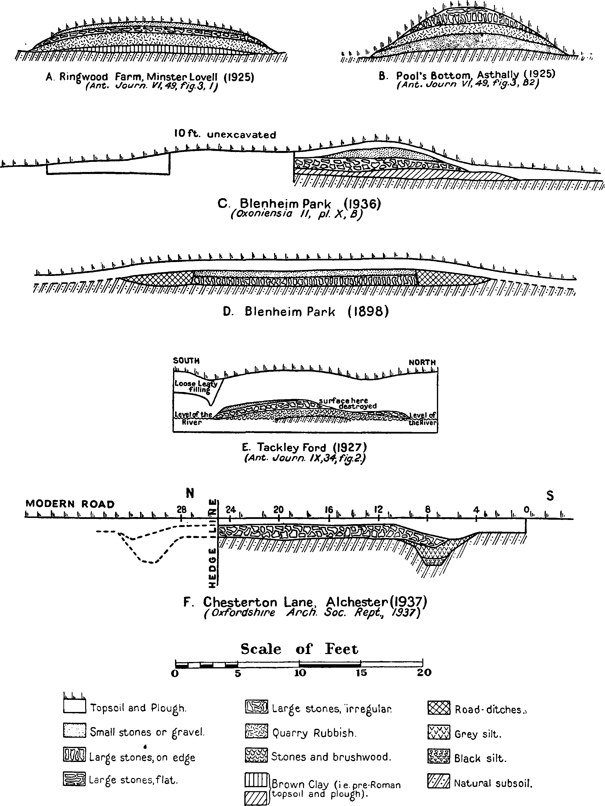
Fig. 18. Sections through Akeman Street at Minster Lovell, Asthally, Blenheim, Tackley, and Chesterton
Having reached Tackley Park, Akeman Street continues westwards, forming the south boundary of the park, and then passing across fields till it crosses the Oxford-Banbury road a few yards north of Sturdy's Castle Inn. (fn. 16) At the top of the plateau here the road seems to have turned slightly southwards and, after crossing a field, follows the line of a grass track to Sansom's Farm on the old LondonWorcester road. Crossing the road, it continues the same alignment along the modern by-road down the slope to Stratford (fn. 17) Bridge, over the Glyme, and up the opposite incline until it reaches the OxfordChipping Norton high-road. The course of the modern by-road east and west of the bridge is by no means straight, and, if it indicates the exact line of the Roman road down to and across the river, the road must have diverged to reach the best fording-place. West of Stratford Bridge the modern by-road and its winding track can be clearly seen at the top of the air-photograph (Pl. XIV, a). After crossing the high-road, the Akeman Street enters Blenheim Park, within which its line, with its side ditches still showing in parts, is easily visible to the north of Furze Plat and south of North Lodge. Its course has a slight convexity northwards, due presumably to difficulties of sighting across the uneven ground. The road leaves the Park, still keeping its same alignment, about 220 yards north of Stonesfield stile. Within Blenheim Park a section through the Akeman Street 'near Stunsfield-gate' is noticed as early as 1780, though no details are recorded (fn. 18) except that it was composed of 'rubble stone'.
In 1898 Haverfield and Grundy (fn. 19) dug two sections across the road, one (Fig. 18, d) 212 yards west of the westernmost farm-building of Furze Plat, and the other south of North Lodge. These sections showed that the road was about 17 ft. wide between side ditches and that its substance consisted of a layer of gravel about 6 in. deep over a layer 10 in. deep of oolite slabs about 6 in. to 1 ft. square, laid at an angle of 20°–25° from the vertical, and sloping in the direction of the road. Between the gravel and the sloping slabs there were, near the crown of the road, a few larger slabs laid horizontally. The course of the road south of North Lodge, where it passes through a gap in Grim's Dyke (Pl. XIV, a), was investigated in 1936. It was found that the road approached the gap, from the east, in a straight line and made a bend to a new alignment a few yards west of the gap. This and other evidence obtained by the excavators supports the theory that Akeman Street follows the line of a pre-Roman track. (fn. 20) The section of the road here (Fig. 18, c) was similar to those excavated in 1898, but no side ditches were visible.
From Blenheim Park westwards the line of the Roman road can be easily traced along parish boundaries between Wootton and Stonesfield on the north and Combe on the south to Bag's Bottom (O.S. 6 in.), (fn. 21) where it leaves the parish boundary for a few hundred yards and veers slightly to the right to avoid a bend in the Evenlode, mounting the west slope of the bottom through a cutting, perhaps made by Roman engineers. It then regains its original alignment and follows it across fields to the Fawler-North Leigh road at Bridge Field Brake. Of its exact course from the bottom of the brake to the modern bed of the Evenlode and the precise point where it crossed the old river bed, which lies east of the modern one, all traces have been destroyed by the building of the railway embankment and changes in the course of the river, (fn. 22) but excavation might solve the problem, and the general line of the road on both sides of the river is still traceable by the parish boundaries between Fawler and Finstock on the north, and North Leigh on the south. West of the river, it follows the parish boundary up the rise across the grounds of Wilcote House (where its line is visible), but having crossed the Finstock–North Leigh road it ceases to form a parish boundary and appears as a broad ridge running across fields (fn. 23) until, just east of Ramsden village, a modern road picks up its alignment. Thence it can be followed continuously along modern roads and tracks, in a straight line through Ramsden and near Whiteoak (Plot's 'Witty') Green, till just before it reaches Riding Lane, the parish boundary between Crawley and Minster Lovell.
From this point westwards for about 1½ miles to Standridge Copse its course has been investigated by members of the O.U.A.S. in 1925. (fn. 24) The road can be traced in its correct alignment through the fields, often as a raised bank, to Wisdom's Copse, about ½ mile east of Asthally. It bends to the right through the copse along a built-up causeway to cross a winter water-course called Pool's Bottom, and then turns SW. again and, passing through Standridge (fn. 25) Copse, regains its original alignment in the field beyond. The excavators found evidence which suggested, but did not prove, that this divergence was due to a desire to make use of a pre-Roman ford. A section (fn. 26) cut through the causeway on the east side of Pool's Bottom showed two successive surfacings, the lower of which continued the gradient down to the ford level, while the upper one became thicker towards the east end of the causeway, and led to a bridge, which was presumably wooden, as no traces of it were found. The width of the road varied from about 20 ft. in Ringwood Farm field to about 10 ft. or less in Wisdom's Copse and on the causeway. Its make-up also varied. At the top of the east causeway (Fig. 18, b) (fn. 27) an under-dressing of stones on edge (fn. 28) was found over a bedding of quarry-rubbish and below a topdressing of large oolite slabs laid flat. But in Ringwood Farm field (Fig. 18, a), in Wisdom's Copse, and towards the bottom of the east causeway, the stones on edge were omitted; the second surfacing of section C, towards the bottom of the east causeway, was of large flat slabs like those of section B 2 at the top of the east causeway. It looks as if a secondary paving of flat slabs was laid down on the causeway when the crossing was changed from a ford to a bridge.
From Standridge Copse westwards for 2½ miles the road is only partly traceable by surface indications, but it has been found on its true alignment by excavation in several places south of Asthall village, (fn. 29) and again at its crossing of the Oxford-Gloucester high-road. (fn. 30) For the whole of its course of nearly 4 miles from Riding Lane to the Oxford-Gloucester road it hardly coincides with field or parish boundaries at all, presumably because in medieval times this part of the country was forested. After it crosses the high-road, however, the NW. boundary of Shilton parish follows it for about a mile, after which the road continues direct across fields to the north corner of Broadwell Grove only making a slight detour at the crossing of Shilton brook. (fn. 31) From here a modern road follows it past Cocked Hat Copse to Bimberry Lodge, a quarter of a mile west of which, proceeding across fields, it enters Gloucestershire, making in a direct line WSW. to Cirencester.
Plot and some later writers claim to have discovered certain diverticula from this road. Some are wholly illusory: others have some slight evidence to support them.
(a) Kennett, (fn. 32) and after him Dunkin, Hussey, Blomfield, and others, described a 'road' leading from the Akeman Street east of Langford in a NE. direction, through Launton to Stratton Audley, Buckingham, and Stony Stratford, but there is difficulty in identifying their landmarks, and the whole story appears to be an aetiological myth to explain the name Stratton Audley, based only on the finding of a 'paved way' in digging a pond in a place called Dunkin's ground: it may be dismissed.
(b) Kennett (fn. 33) also described a 'road' leaving the Akeman Street near Chesterton and passing through Middleton Stoney. This road, 'falling into Wattlebank or Avesditch, might lead to Banbury'; but such a course has not even directness to recommend it.
(c) Dunkin, (fn. 34) and after him Blomfield, describes a 'road' leading 'from the Akeman-street, near Graven-hill, into the Bucknell road, above the stone pits'. Foundations of such a road were said to be visible 'in Mr. Coker's close': but the account will not stand the light of reason.
(d) Hussey, (fn. 35) and after him Blomfield, suggests that a road led SE. from the Akeman Street at Langford, along Langford Lane to the 'Roman Camp' at Muswell. Such a road has no factual evidence to support it, and the earthworks on Muswell Hill are now thought to be of the Civil War period. (fn. 36)
(e) Various writers, from Plot onwards, have claimed that a branch road diverged from the Akeman Street northwards, just west of the NW. corner of Kirtlington Park, but how far it went in its northerly course and whether there was any similar branch southwards at this point they could not tell. The question is complicated by two facts: first, the existence at this point of a pre-Roman N.-S. track called the Portway, which has been traced, however vaguely, by Beesley and other writers, from Daventry to Berkshire via Oxford; (fn. 37) and second, the existence of a bank called Aves Ditch, Wattle Bank, or Ash Bank, crossing this Portway at an angle NW. of Kirtlington and running NNW.-SSE.
Plot (fn. 38) thought that both the Portway and Aves Ditch were in Roman times made into diverticula from the Akeman Street. Later writers tend to suggest that one or other, but not both, were romanized. Codrington, for instance, marks a side road here along the line of the Portway (as marked on O.S.) from the Akeman Street to Aynho, and notes that in Northamptonshire, east of Aynho, Morton (fn. 39) says it was still pitched with stones in 1712. Grundy, (fn. 40) on the other hand, claims that a romanized road ran along Aves Ditch, just as a Roman road ran along part of the Wiltshire Wansdyke. (fn. 41) But recent excavations by Capt. C. Musgrave (fn. 42) have proved conclusively that this earthwork is a dyke, formed of a ditch and bank, and not a road at all, and also that it ended exactly where O.S. 6 in. Oxon. xxii S.W. marks its end. It never descended the hill to the Tackley ford.
No romanized branch-road south of Akeman Street and east of the Cherwell has ever been suggested. There are, however, in the Saxon charters, three notices of (paved) 'streets' on the Banbury-Oxford ridgeway (see p. 280, (c)), all south of its crossing of Akeman Street at Sturdy's Castle. It looks, therefore, as if the route for S.-N. traffic here in Roman times lay up the ridgeway as far as Akeman Street, then across Tackley Ford, and so north again via the Portway. But the evidence is very slender.
(f) Plot's diverticulum northwards in Blenheim Park (fn. 43) is Grim's Dyke and not a Roman road.
(g) Warton (fn. 44) suggests a diverticulum from Akeman Street through Fifield to Idbury Camp, because a charter of 1205 mentions a 'Street' in Fifield. This can only refer to a paved, romanized portion of the ridgeway from Burford to Stow-on-the-Wold.
(h) Monk (fn. 45) suggests a diverticulum from the Akeman Street at Signet, near Burford. His only proof of this appears to be the reported finding of Roman coins at Signet (p. 334).
The North-South Road.
This road, (fn. 46) which traversed the whole county from Water Stratford to Dorchester, is first mentioned by Camden, who calls it the Akeman Street, being deceived by local tradition, (fn. 47) and says that it ran from Wallingford to Banbury over Otmoor. Plot more correctly describes it as the 'Roman Way between the old city of Alchester' and Calleva (which he takes to be Wallingford). He brings it over Otmoor (mentioning stones found upon and about the ridge), under Beckley Park wall, through the wood near Stocker's (i.e. Stow Wood), across the London-Worcester road, over Bayard's Watering Place (i.e. Bayswater), leaving Headington Quarries on the right and Shotover Hill on the left, through Magdalen and Brasenose Coppices, past the Baldons, 'and so for Wallengford; going over the River at Benson, . . . where it may be seen again running West of the Church, and is there called by the Name of Medlers-bank'. He claims that the road diverged out of the direct Alchester-Wallingford line in order to approach Oxford. He also takes pains to correct Camden's statement that this road is the Akeman Street, and is therein followed by the later editors of Camden, Gibson, and Gough. (fn. 48) Stukeley tells us that he saw many evidences of its paving between Alchester and Otmoor, and that the road ran thence by Beckley and Shotover, 'and so I suppose passes the Thames at Sandford below Oxford'. (fn. 49) He also traced this road correctly north of Alchester to near Caversfield, but thenceforward diverged it from its true alignment to bring it, misled by etymology, through Stratton Audley, 'and so to Radley (i.e. Radclive) by Buckingham'. (fn. 50)
Hussey in 1841 wrote a remarkably accurate account of the road, tracing in detail its course from Alchester to Dorchester, and sketching out a possible continuation of it southwards across the Thames to Streatley, to meet the Icknield Way. Incidentally, with his usual perspicacity for surface indications, (fn. 51) he picked out a course for this extension along the farm-way leading from Brightwell Barrow ridge to Sotwell, a course recently suggested by Grundy and others to be the correct line of the road. (fn. 52) Hussey's work still remains basically accurate, and the reader is therefore referred to his description and detailed map of the road's course for a full survey. It is here only necessary to give some general account of its line, and to indicate the points where more recent investigation has amplified or corrected Hussey's information.
Curiously enough, Hussey contented himself with describing the line south from Alchester, though he saw (fn. 53) that the road had a definite continuation north from Alchester along the line of the turnpike road. Actually, the road, which has come in a SW. direction from Stowe Park, Bucks., (fn. 54) meets the Oxfordshire-Northamptonshire county boundary at the River Ouse, SW. of Water Stratford. The county boundary follows it till it meets the modern Banbury-Buckingham road. From this crossing the modern Buckingham-Bicester-Oxford road (which for the greater part of its course to Bicester keeps to parish boundaries) takes up the line of the old Roman road and follows it to Alchester with no noticeable deviations save at Bicester itself. There the modern road runs along two sides of a triangle through the main streets of the town, while the Roman road skirts Bicester to the west in a straight course, first along the line of a modern street, and then by field boundaries and a lane till it abuts on the Bicester-Oxford road at King's End. The village of Stratton Audley, though it must have taken its name from the road, is ½ mile east of the road's course.
Some 600 yds. north of Alchester the course of the road changes from SSW. to due south, and shortly afterwards, a quarter of a mile north of Alchester, it crosses the Akeman Street, here represented by the side road to Chesterton. (fn. 55) Entering Alchester by the north gate, it passes centrally (fn. 56) across the inclosure and leaves by the south gate, where its paving stones may still be seen in the banks of Chesterton Brook. To judge from the lie of the existing raised banks just within the south gate of the town, the road must have taken a Z-bend here (Fig. 19), a bend which is not noted by Hussey or marked on Brown's plan, but appears on the 6-in. and 25-in. O.S. maps, and is noted by Hawkes (see p. 282). Hussey records (fn. 57) that south of Alchester the road is represented by a bank 20 yds. (Stukeley said 100 ft.) wide and 2½ ft. high, and that a section of it showed it to be 'made of broken stones laid on a bed of black mould'. (fn. 58) South of Merton Hussey noted traces of a stone ford across a small brook (the River Ray), immediately south of which it crosses a rise called Strettle or Street Hill.
The modern north-south track across Otmoor (fn. 59) follows the line of the Roman road and was still in Hussey's time paved in places with a firm layer of stones. (fn. 60) Leaving Otmoor, the road passes SSW. to Beckley along a course fully described by Hussey. (fn. 61) It crosses the main street of Beckley at the Abingdon Arms Inn, and a modern path follows its line through a cutting to the NE. corner of Stow Wood. Along the east side of the wood its line is visible as a raised bank, and here in parts its original paving could still be seen in Hussey's time. South of this it mostly follows field and parish boundaries until it joins the line of the Studley-Headington road where that road makes a bend to the south, and here the Roman embankment can be seen as a rise underneath a garden wall west of the road. Thereafter the modern road follows it to Stow Ford Farm, and there leaves it, bending slightly SSW. Some yards north of Bayswater Brook and east of the modern road a fallen tree can be seen (1937) which has some of the Roman paving stones still clinging to the roots. Thence the road passed straight up the rise till it crossed the modern Oxford-London high-road. South of this its line is taken up by the newly laid-out Ridgeway Road, and a section of the Roman road is to-day visible in the south bank of the high road, at the west side of Ridgeway Road. The road surface consists of small cobble-paving laid on a bed of brown clay. (fn. 62)
The line of the Roman road southwards of this point for about 2 miles has been largely destroyed by quarrying and by modern suburban development, but Hussey (fn. 63) notes traces of paving in the quarries and the robbing of its embankment in the field north of Magdalen Coppice; and Manning saw a section of road in the brickyard on the north side of the old road over Shotover. (fn. 64) Southward of this there were no sure traces of the road, even in Hussey's time, until it had crossed Bullingdon Green. Slight traces of a raised bank across the uncultivated land east of Brasenose Farm, roughly in the correct alignment, are of dubious import. Having crossed Bullingdon Green and the modern CowleyHorsepath road, the Roman road is picked up by modern lanes and tracks along the parish boundaries of Cowley, Littlemore, and Sandford on the west and Horsepath and Garsington on the east. This section of the road is called Straet in the Saxon charters of Cuddesdon and Sandford. (fn. 65)
Between Sandford Brake and Toot Baldon the direct line would run along or near field boundaries and tracks till it reached the modern road from Toot Baldon to Nuneham Courtenay at the first bend of a Z, and then along, or slightly east of, the central stroke of the Z to pick up the line of a lane over Pebble Hill to Parsonage Farm. This lane, says Hussey, (fn. 66) has a hard bottom of large stones and has long been known by tradition as the Roman road. Thence the road skirted the east of Marsh Baldon Green. Southwards of this Hussey assumed that it diverged along the line of the 'road from Baldon to Dorchester across the fields' in order to avoid a watercourse and swamps. The O.S. maps, on the other hand, mark it tentatively in its true alignment. Possibly Hussey was right, for there are neither surface indications nor field boundaries on the true line.
About 1,200 yds. south of the Clifton Hampden-Chislehampton road the Baldon-Dorchester field track picks up the general alignment of the road once more. South of the Burcot-Drayton road the course of the Roman Way is marked first by a grass track between hedges, and then by the line of the Oxford-Dorchester road into Dorchester itself.
How the road passed through or round Dorchester and across the River Thames is not now identifiable. Older antiquaries thought they could discern traces of a ford at the junction of the Thame and the Thames, and of a road leading therefrom on the Berkshire side in Little Wittenham Copse. (fn. 67) But Dr. Grundy has recently demonstrated (fn. 68) from Saxon charters that a Roman road led southwards along the boundary between Sotwell and Brightwell parishes, starting from a point on the River Thames called in the charters Old Street Ford, half-way between Dorchester and Shillingford, NE. of Lower Hill Farm (O.S. 1 in.). If this is the continuation of the main North-South road (as seems to be the only reasonable assumption) a connecting road must have run from Dorchester along the line of the modern high road to Benson. Why should the Roman road take such a curious bend when it might have gone straight across the river? It is possible that, if the road was a line of advance made in the first century to bring supplies up from the south to the successive frontier lines, (fn. 69) it deliberately avoided the Dyke Hills, where, as is now known, a native settlement then existed. Later, when Britons and Romans were living here on friendly terms, a ford at the confluence of the rivers may have been used to give quicker access for light traffic to and from Dorchester, though the main road continued to follow the devious route.
One certain (no. c below) and some doubtful or impossible diverticula from this road have been recorded:
(a) The O.S. map of Roman Britain (2nd ed., 1924), on the evidence of field-boundaries, marks a line of road leading northwards from Wood Eaton via Islip to near Bletchingdon.
(b) Plot (fn. 70) describes a portion of road which he thought represented either a line of road from Alchester to Oxford or else a winter way on drier ground corresponding to the summer way across Otmoor. He traced it from near Noke to Drunshill and there lost it. He also found traces near Elsfield and Headington and Marston Lane, and adds that it 'by its pointing shews as if it once passed the river above Holy-well Church, straight upon St. Giles's'. But Plot's account is now indecipherable through loss of landmarks, though his road must have represented a very wandering line. Hussey (fn. 71) does his best to disentangle the web, but can derive little of value from the threads. A piece of 'road lying NW.-SE. in the fields north of Noke was suggested to him by some paving found in ditching, and farther south, where the Islip-Wheatley road crosses the valley NE. of Drunshill, he noted an old line of road (fn. 72) meeting the modern road and running southwards along its east side. Hussey makes this supposed road cross the Islip-Wheatley road aslant and run up through the wood by a hollow way. Crossing the Stow Wood-Elsfield road, he finds it again in the fields to the south, making for Headington, a little to the west of the church. In this part of its course he found signs of stone paving by boring. He lost all trace of it, however, at the top of the rise above Bayswater Brook. 'Yet,' he says, 'this fragment which remains has not only the most evident features of a Roman road, but also seems to have been of a large size in breadth and height, quite equal in these respects to the Dorchester and Allchester road.' He adds, (fn. 73) with some reason, that the Wood Eaton and Drunshill settlements 'confirm the belief that the road along this line was a Roman work', which he thinks may have been an earlier route than the Otmoor road. Can we go further and suggest that it was pre-Roman in origin? A few years after Hussey wrote, the Roman villa at Headington Wick (see p. 320) was discovered, and Jewitt (fn. 74) claims to have traced this road not only down to 'the hedge of a field adjoining the remains of the buildings', but also from Headington by a ridge leading in a direct line, represented to-day by Windmill Road, Headington, and its continuations, (fn. 75) to the main road on Bullingdon Green. This is supported by a Saxon charter of Cuddesdon: (fn. 76) the survey runs along the west boundary of Horsepath northwards 'along the Street as far as the Cross roads', and the modern boundary of Horsepath leaves the NorthSouth Roman road just at the point where this branch road would have abutted on to it. (fn. 77)
(c) Hussey (fn. 78) notes that traces of paving had been found along the line of a hedge pointing NW. towards the Roman road north of Beckley. He rightly suspected it might lead from a house, for the Beckley villa (see p. 320) was later discovered quite close to the SE. termination of this line.
(d) Manning (fn. 79) records the discovery of a stone-pitched road running NW., just north of the upper road from Garsington to Oxford, opposite Kiln Farm (O.S. 1 in.). It pointed towards the main Roman road near its crossing of the line of the Oxford-Wheatley Railway.
(e) Warton (fn. 80) invents a road diverging westwards from the main Roman road towards a ford called Stanford (? Sandford) opposite Radley. Hussey rightly pours scorn on Warton's suggestion.
(f) We have seen (p. 276) that Plot describes the Alchester-Dorchester road as 'going over the River at Benson, alias Bensington, where it may be seen again running West of the Church, and is there called by the Name of Medlers-bank'. (fn. 81) This bank is probably part of the square entrenchment described in Gough's Camden and still existing in part to-day. (fn. 82) Gough adds, 'a Roman road is said to lead to a ford below Shillingford, where piles and beams have been taken up'. Later, the Rev. J. E. Field (fn. 83) attempted to trace the course of a Roman road through Benson village. Not one of these three authors brings forward any sure evidence, and we may ignore their theories. There is, however, inherent probability in the suggestion made by Codrington (fn. 84) that a Roman road ran from Dorchester via the line of the modern high road to Benson to meet the Icknield Way on the Oxford side of the Thames, though so far no archaeological evidence has been adduced in its support. (fn. 85)
Romanized Roads.
Apart from the true Roman roads in Oxfordshire, there is evidence that some at any rate of the pre-existing British trackways had been paved and romanized in parts in Romano-British times. Two of these, the Portway and the road which runs past Drunshill and Wood Eaton, have already been mentioned (pp. 275, 279). Evidence for other romanized ways is provided by the occurrence of the word 'Street', i.e. paved road, in Saxon charters printed in Dr. Grundy's book: (fn. 86)
(a) In the charter of Brightwell Baldwin (op. cit., p. 11) is a mention of a 'Street Ford'. This cannot refer to a part of the Icknield Way, which would not ford a river. Grundy suggests that the reference may be to a detached portion of Brightwell on the North—South Roman road. Alternatively, it might refer to a part of the branch Roman road (if such an one there was, see p. 279) from Dorchester to Benson and the Icknield Way.
(b) In the Cuddesdon charter (op. cit., pp. 21–2) is a mention of a 'Street' which Grundy identifies as the modern Oxford-London road east of Wheatley village. This road here forms part of the Shotover ridgeway (Grundy's road 6, op. cit., pp. 100 ff.).
(c) In three charters, Cutslow (op. cit., p. 25), Shipton-on-Cherwell (op. cit., p. 56), and Tackley (op. cit., p. 62), is a mention of a 'Portstreet' or 'Street', an old ridgeway running south-north and corresponding to the modern Oxford-Banbury road (Grundy's road 2, op. cit., pp. 95 ff.). (fn. 87)
(d) In the Shipton charter (op. cit., p. 57) is a mention of the 'High Street', which is identified by Grundy with the branch ridgeway that ran SW., leaving the Oxford-Banbury road where it crossed the Akeman Street at Sturdy's Castle. This ridgeway ran via the hills SE. of Bladon to Handborough and Witney, and is referred to again in the Eynsham charter as a 'Port Street' at the NW. corner of Eynsham Park (op. cit., p. 35). A 'Street' or 'Wood Street', W. of Witney (op. cit., pp. 81 and 83), must refer to a continuation of this ridgeway from Witney to Burford along the line of the modern high-road. These two roads are Grundy's roads 3 and 4 (op. cit., pp. 98–9).
(e) In the first Tadmarton charter (op. cit., pp. 65 and 71) there is mention of a 'Street' which must be a paved portion of the Cotswold ridgeway (Grundy's road 1, op. cit., pp. 94–5).
Between them these notices tell us that of seven main ridgeways mentioned by Grundy five were romanized and paved, at least in part. Of the other two, one is the Wytham ridgeway (op. cit., p. 99), which runs in Berkshire, connecting the fords at North Hinksey (fn. 88) and Swinford; the other is the Chiltern ridgeway (op. cit., pp. 102 ff.), which entered Oxfordshire east of Chinnor and, sending off branches during its course across the county, first at Nuffield, and again at Checkendon, left the county by fords at Wallingford, Goring, and Caversham. Though there is no evidence for its romanization within the county, there is mention of it as a 'Street' in the Monks Risborough charter (fn. 89) just north of the county boundary. We have, therefore, evidence for a considerable amount of paving on all the main pre-Roman ridgeways of Oxfordshire. This explains why so few new roads were made by the Romans in such a thickly populated district.
One further road remains, the famous Icknield Way, about which so much has been written (fn. 90) and yet so little of whose history is known. There is no evidence for any paving along its route through this county, but the Berkshire charter of Uffington calls it Icknield Street, (fn. 91) and Grundy detects evidence of the straightening of it in Roman times between Upton and Wantage. (fn. 92) In Oxfordshire and Buckinghamshire three lines of road are marked on the O.S. maps by the name of Icknield:
1. Called Upper Icknield Way, running south of Princes Risborough and Saunderton. This just touches Oxfordshire east of Chinnor.
2. Called Lower Icknield Way, running north of Chinnor and Aston Rowant, and lost at the modern Oxford-Stokenchurch road.
3. Called Icknield Way, starting a mile south of this on the modern Oxford-Stokenchurch road and winding thence SW. above Watlington to Beggar's Bush Hill on the modern OxfordHenley road, where it turns south and proceeds to Goring.
Grundy, who describes these three roads and their courses in detail (op. cit., pp. 110 ff.), suggests that no 2, which adopts a very straight course and touches no villages, may be a way made in RomanoBritish times as an alternative to the true Icknield Way, represented by nos. 1 and 3, the summer way to the Chiltern ridgeway. (fn. 93)
For the so-called Roman road found in cellars about 11 ft. below the street surface in St. Aldate's, Oxford, see p. 303.