A History of the County of Oxford: Volume 12, Wootton Hundred (South) Including Woodstock. Originally published by Victoria County History, London, 1990.
This free content was digitised by double rekeying. All rights reserved.
A P Baggs, W J Blair, Eleanor Chance, Christina Colvin, Janet Cooper, C J Day, Nesta Selwyn, S C Townley, 'North Leigh: Introduction', in A History of the County of Oxford: Volume 12, Wootton Hundred (South) Including Woodstock, ed. Alan Crossley, C R Elrington (London, 1990), British History Online https://www.british-history.ac.uk/vch/oxon/vol12/pp213-219 [accessed 30 April 2025].
A P Baggs, W J Blair, Eleanor Chance, Christina Colvin, Janet Cooper, C J Day, Nesta Selwyn, S C Townley, 'North Leigh: Introduction', in A History of the County of Oxford: Volume 12, Wootton Hundred (South) Including Woodstock. Edited by Alan Crossley, C R Elrington (London, 1990), British History Online, accessed April 30, 2025, https://www.british-history.ac.uk/vch/oxon/vol12/pp213-219.
A P Baggs, W J Blair, Eleanor Chance, Christina Colvin, Janet Cooper, C J Day, Nesta Selwyn, S C Townley. "North Leigh: Introduction". A History of the County of Oxford: Volume 12, Wootton Hundred (South) Including Woodstock. Ed. Alan Crossley, C R Elrington (London, 1990), British History Online. Web. 30 April 2025. https://www.british-history.ac.uk/vch/oxon/vol12/pp213-219.
Introduction
North Leigh, known chiefly for its Roman villa and for a remarkable parish church, lies c. 2 1/2 miles (4 km.) north-east of Witney, just off the road from Witney to Woodstock. (fn. 98) The ancient parish was measured in 1876 at 2,423 a., (fn. 99) but the annexation in 1932 of the civil parishes of Wilcote and Osney Hill (77 a.) increased the area to 2,819 a.; North Leigh was further enlarged in 1953 by the incorporation of 30 a. from the north-west tip of Eynsham. (fn. 1)
The boundary of the ancient parish was marked by natural features on the east, where it followed the river Evenlode and a small tributary known in the Middle Ages as Leyham brook, (fn. 2) and on part of the south by an ancient east-west ridgeway referred to in 1005 as the port street, (fn. 3) running through Long Hanborough and Bladon to Oxford. (fn. 4) Instead of following the ridge west to New Yatt, however, the boundary turned south towards South Leigh near the later north lodge of Eynsham Park to take in a large area of heath. There and on the west the parish boundary was characterized by ancient lanes and by hedges, often thickly grown and ditched. A charter boundary of 969 for the neighbouring manor of Witney refers to a hedgerow apparently running from North Leigh Lane through what was to be New Yatt. (fn. 5) The boundary made right-angled turns at New Yatt, further north at the crossing of a tributary of the Evenlode, and at the junction with Burford Way. The northern boundary followed the line of Akeman Street west of the Evenlode but ignored it on the east to take an irregular course to Stonesfield ford. Osney Hill's boundary with Eynsham on the east was marked by Wood Lane, that with Cogges on the south by the line of a former stream.
North Leigh lies on the northern edge of a belt of Oxford clay which locally forms a high ridge that stretches from New Yatt to East End and rises to 140 m. in the centre of North Leigh village. (fn. 6) To the south the former heath slopes gradually to c. 120 m. at Cogges Wood; to the north the ground falls away more sharply to form an amphitheatre overlooking a wide valley. Through the valley an unnamed stream, probably known in Saxon times as the Itchen, (fn. 7) meanders to join the river Evenlode at Ashford bridge. Its line apparently follows that taken by the river Windrush before the latter changed course to flow south into the Thames. Even in historical times the stream was bigger, destroying part of Holly Court by floods in the 15th century. (fn. 8) East End hamlet stands on a ridge between the valley to the west and that formed by the Evenlode. On the sheltered slopes of the latter valley, within a loop of the river, lies North Leigh Roman villa. The Oxford clay, difficult to plough, was given over early to closes that formed a crescent from East End to New Yatt. North and west of the clay are outcrops of cornbrash and forest marble, the latter quarried for freestone at East End for 500 years or more. Much of the centre of the parish is Great Oolite stonebrash given over to arable. Meadow lay mainly on the alluvium lining the Evenlode. Gravel deposits south of Bridewell Farm, northeast of Holly Court, and at the west end of Boddington Lane were quarried at various times, that in Boddington Lane also providing limestone for burning. The parish church and nearby houses are built on an isolated deposit of northern drift. Further deposits overlie the clay at the top of Church Road and along Park Road, and have long been used for settlement. Below Bridewell Farm the stream is lined with beds of tufa up to 8 ft. deep, deposited by hard -water springs.
North Leigh was said in 1300 to have been taken into the royal forest of Wychwood after 1154, (fn. 9) and fines for waste and assarts were paid to the Crown in the later 12th and the 13th century. (fn. 10) In 1279, however, the abbot of Netley allegedly had a wood and three groves out of the regard and allowed the removal of timber with out licence, and a perambulation of 1298 confirmed that only the western half of the parish was afforested. (fn. 11) The perambulation seems to have begun near the south-west corner of the parish, following a stream northeastwards to Madley well, probably the later village pond. (fn. 12) It passed along Church Road to 'Grundesweleye, and so along a hedge to Snellesleye (or Sullesleye), and so to Forsakenhoke'. 'Grundesweleye' may have been on the western parish boundary at Lady well, by Grunsmoor; in that case 'Snellesleye' perhaps lay at the junction of the North Leigh boundary with the south-east tip of Wilcote. The perambulation, therefore, may have left the road from North Leigh to Wilcote at the fork to Ashford bridge, and turned west to pass north of the later site of Bridewell Farm to reach the parish boundary at Lady well, where it turned south to North Leigh Lane. It presumably then followed the lane westwards to pass south of Shakenoak Farm. It seems that the eastern half of the heath and the whole of the north and east of the rest of the parish were thereby excluded from the royal forest. (fn. 13) When the forest was surveyed in 1609 the only apparent difference was that the whole of the heath south of the New Yatt road was considered to lie within the bounds of Wychwood: the measured area of 271 a. is too great for the western half alone. Also within the forest at the later date were 31 houses, including the rectory and the former manor house, Heycroft, Caden Hill, and 'another common field adjoining', presumably Edgings field. (fn. 14) That survey seems to have formed the basis of a Crown claim to the ownership of land in North Leigh, a claim successfully refuted by the lord of the manor, Sir William Pope. (fn. 15)
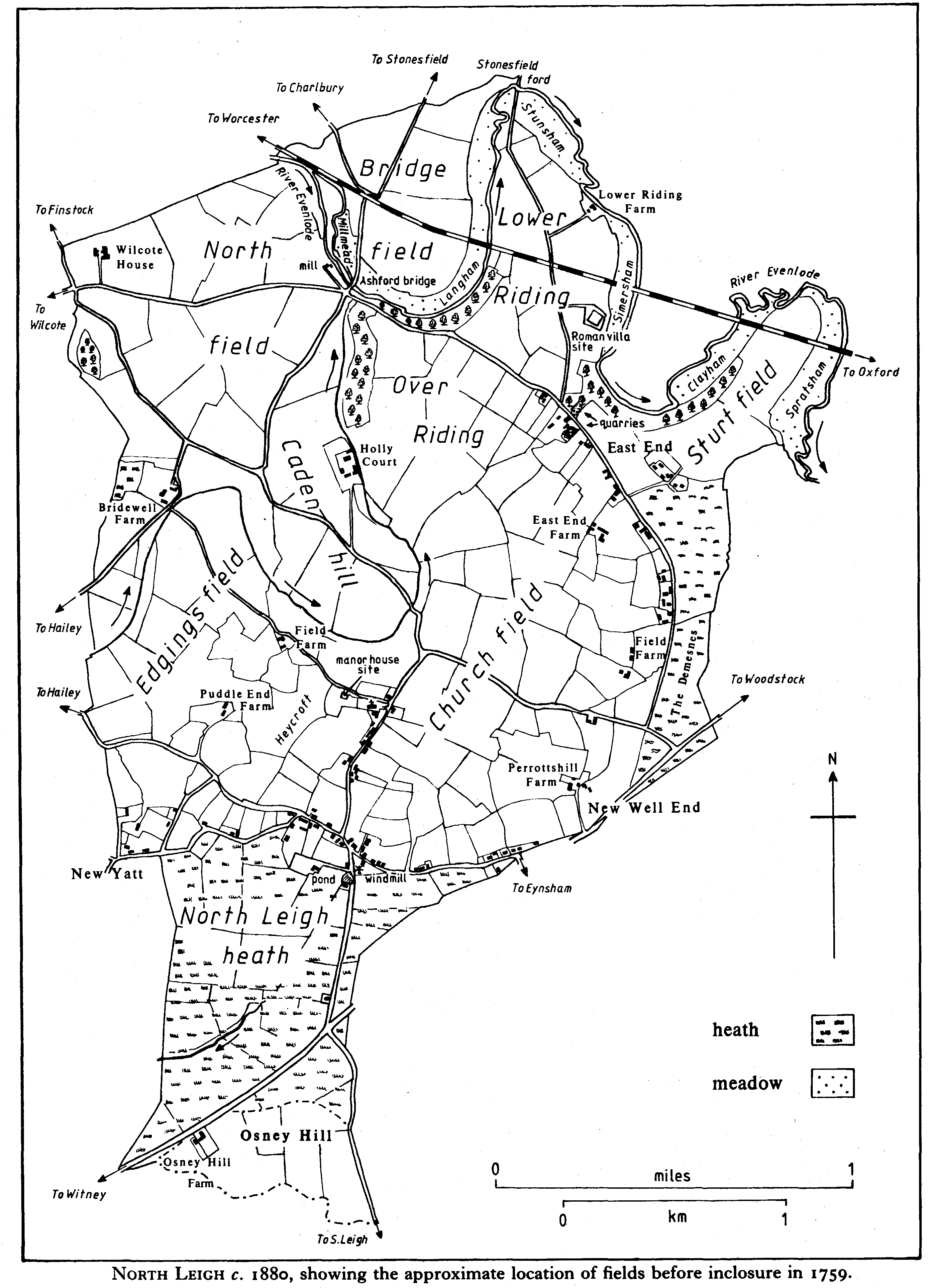
North Leigh c.1880 showing the approximate location of fields before inclosure in 1759.
The ancient ridgeway, the port street of 1005, (fn. 16) ran along part of the southern parish boundary. The name survived in the mid 17th century in Portstreet way, which seems to have run from near Holly Court to the east end of Bond hatchway, the later Boddington Lane, and so to the ridgeway. (fn. 17) South of Perrottshill Farm the ridgeway divided, westwards through New Yatt, the line obscured by the irregularity of the later road and by modern housing, and southwest towards Witney bridge, probably following the line of the parish boundary rather than the straighter turnpike road, before turning southwest past Osney Hill Farm. The road was turnpiked in 1751 and disturnpiked in 1869. (fn. 18) South of the road the track along the boundary continued as Wood Lane, passing between Cogges and Eynsham to South Leigh. At inclosure in 1759 a direct road, later known as Common Road, was made from North Leigh village to join Wood Lane at the turnpike road. (fn. 19) The way to Eynsham and South Leigh from East End was along Cuckoo Lane across Eynsham heath. The awkward right-angled turns linking the East End road with that from Witney to Woodstock seem to have been laid out in the 19th century, perhaps in 1814, when heath unaffected by inclosure in 1759 was the subject of a second award: previously there had been a junction east of Perrottshill Farm, at the southwest corner of the Demesnes. (fn. 20) The road to East End was probably in origin another ancient ridgeway, giving access to Ashford, Wilcote, and Stonesfield ford.
Church Road was known in the Middle Ages as Kynne Street, presumably after the family of freeholders of that name whose house adjoined the street. (fn. 21) In the earlier 16th century it was called via regia, (fn. 22) and the name King Street, in use from the late 16th century, (fn. 23) may have derived from that, from the name Kynne, or from the King family, occupiers of the manor house. The name Kingston Lane, common in the mid 19th century, survived into the 20th but was gradually replaced by Church Road or Lane. (fn. 24) The narrowing of the road between Church Farm and the former vicarage resulted from mid 19th-century encroachments. (fn. 25) In the Middle Ages east-west routes from North Leigh headed towards the river crossing at Minster Lovell and the market at Burford. (fn. 26) New Yatt Lane, the road from Wilcote, and North Leigh Lane, known as Green Lane at its eastern end, survive as minor roads; Burford Way, which leaves the parish south-west of Bridewell Farm, at inclosure a 40-ft. public highway and still in regular use in the earlier 20th century, (fn. 27) became increasingly overgrown. Procession Way, so called in 1581 (fn. 28) and presumably the route taken in perambulating the parish boundary, ran north-westwards from the church. It survives as a bridleway towards Bridewell Farm, but is lost beyond Burford Way; possibly it reached the parish boundary at Lady well. Kyte Lane, mentioned from the mid 16th century, (fn. 29) is the lane between the New Yatt road and Green Lane. In the north the convergence of roads and footpaths on Ashford bridge denotes its importance as a river crossing, providing access to Enstone and the north. (fn. 30) The bridge was rebuilt in 1464 (fn. 31) and possibly in 1674. (fn. 32) In 1835 it was said to be 'in a dilapidated state and very old'. At that time it was of two arches, each divided by a pier; the centre of the bridge, unarched, was built upon an island. It was rebuilt as a twoarched bridge, without intermediate piers, by James Lord, a local mason. (fn. 33) The bridge was rebuilt again in 1967. (fn. 34) Small stone bridges were recorded from the 15th century north-east of Field Farm and east of Holly Court. (fn. 35) Bridgefield bridge was constructed of stone over the Oxford-Worcester railway line, opened in 1853; it was extensively repaired in brick c. 1980. (fn. 36) A proposal to build a station there in 1899 was not adopted. (fn. 37) North Leigh's nearest station is that at Hanborough. A station on the Witney branch line was opened at Eynsham in 1861 (fn. 38) and closed in 1962. (fn. 39)
Carriers were recorded in 1841 and 1851; (fn. 40) in 1907 twice-weekly services were begun to Oxford and to Witney. (fn. 41) Before then North Leigh was presumably served by carriers passing through. A post office was recorded intermittently from 1854, (fn. 42) and a permanent office from the 1880s at a house east of the Woodman inn; (fn. 43) it was removed in 1953 to Common Road. A mains water supply was provided to North Leigh village in 1935 and to East End in 1937. Mains electricity was introduced in 1938. (fn. 44) A mains drainage scheme was completed in the late 1950s. (fn. 45) From 1976 to 1985 Boddington Lane quarry was a county council waste tip. (fn. 46)
Earthworks of the north Oxfordshire Grim's Ditch run east-west across the former heath north of Osney Hill Farm, but no related artefacts have been found. (fn. 47) North Leigh Roman villa overlies a Belgic Iron Age settlement. Sherds relating to that settlement have also been found nearby at East End quarry. Occupation of the site seems to have been continuous into the Roman period. The villa, of the winged-corridor type, was built c. 100 A.D., one of several villas in the vicinity of Akeman Street. It was rebuilt and enlarged more than once until by the 4th century it had become a substantial courtyard house, the centre of an important estate, with fine tessellated pavements, plastered and painted rooms, and baths and hypocausts. It has been conjectured that the villa belonged to a noble family of the Dobunni and was perhaps abandoned in the late 4th century or early 5th, the likely date of a fire there. There is evidence of squatter occupation thereafter. (fn. 48) The villa lies in an area that seems to have reverted to scrub before being cleared in the Middle Ages; medieval field names give no indication of awareness of the site. Thomas Hearne's statement in 1725 that Mr. Perrott had removed a tessellated pavement found 'by North Leigh' (fn. 49) seems to fit better the discovery of the villa at Stonesfield, (fn. 50) although the description is odd from a man who knew the area well. Otherwise the North Leigh villa was not recorded until 1783, as a 'spreading tumulus, consisting of rubbish and fragments of Roman bricks and cement'. (fn. 51) Excavations were carried out intermittently from 1813 to 1816. Following extensive damage caused by souvenir hunters in 1815 a keeper's cottage was built and the excavated area was partly roofed over. (fn. 52) Excavations begun again in 1910 and continued sporadically until 1976 have still not completely uncovered the site. In 1952 the duke of Marlborough transferred the site to the Ministry of Works, and it has become a popular attraction. (fn. 53) Romano-British sherds and building material found north of Osney Hill Farm have been interpreted as the remains of a small, probably short-lived, settlement of the 2nd or 3rd centuries. (fn. 54) A coin, a seal-box, and three intaglios found in 1910 near Bridewell Farm seem to relate to the nearby villa at Shakenoak, in Wilcote parish. (fn. 55)
The remains of eight Saxon burials, possibly of the 7th century, were discovered in 1928 near the turning to Holly Court from the Wilcote road. (fn. 56) Whether or not the cemetery was connected with 7th- and 8th-century occupation of the Shakenoak villa, the area between the two sites probably had some Saxon settlement. Boundary charters of 969 and 1044 refer to yccenes feld, meaning 'open land of the river Itchen', apparently that very area, containing the 14th-century Echenesfeld, later Edgings field. (fn. 57) South of Edgings field, perhaps near the church, there is likely to have been the leah (clearing) from which the parish derived its name. (fn. 58) Known initially as Leigh, North Leigh was by the early 13th century (fn. 59) so distinguished from nearby South Leigh.
In 1086 forty-one tenants and a servus were enumerated. (fn. 60) There seems to have been a large increase in population by 1279, when 116 free and customary tenants were recorded on the manor. (fn. 61) Pressure of population is suggested by a standard villein holding of only 1/2 yardland, and by a large number (40) of cottagers, many with only a small amount of assarted land. That level of population was probably not approached again until the 18th century. In the earlier 14th century the parish was probably not only populous but poor, (fn. 62) and it may have struggled to recover from the disasters of that period, for in 1377 only 111 taxpayers were recorded. (fn. 63) The scattered nature of settlement in North Leigh was apparent in the 13th century. Stephen of East End was mentioned in 1256, (fn. 64) and the family names Whitehill, Cross (de cruce), and Miller, recorded together in 1279, (fn. 65) perhaps suggest settlement at Ashford mill and at the nearby crossroads adjoining Whitehill. New Well End, the area containing the later Perrottshill Farm, was mentioned as a settlement from the late 15th century, (fn. 66) by when it was probably long-established. At Field Farm, west of the church, a hollow way and earthworks denote settlement, which has not been dated. (fn. 67) The area was known in the 17th century as Town Closes. (fn. 68) New Yatt, which lies partly in North Leigh parish and partly in Hailey, is characterized by small closes, apparently ancient, and isolated houses, but no reference has been found before the late 16th century. (fn. 69) North Leigh apparently was more populous in the later 16th century than in the 17th and early 18th: in the 1580s there were c. 14 baptisms a year, compared with c. 10 between 1600 and 1720. The fall may relate to heavy mortality, particularly in the years 1616-17 and in the late 17th century. The parish was also badly affected by the smallpox epidemics of the 1720s. (fn. 70) Even so the returns of 109 adult males in 1642 and 265 adults in 1676 suggest a total population closer to 400 than to 300. (fn. 71) The higher figure is supported by the assessment of 109 households for hearth tax in 1662. That 43 of them were exempt confirms the impression of widespread poverty in the previous century. (fn. 72) There were said in 1738 to be c. 90 families in the parish, (fn. 73) and baptisms thereafter consistently outnumbered burials. Estimates of the number of houses in the parish in the later 18th century varied from 100 to 120, (fn. 74) apparently an exaggeration, since in 1801 there were 72 occupied by 85 families, comprising 517 people, and 7 uninhabited houses. The population did not increase rapidly in the 19th century as elsewhere, reaching a peak of only 738 in 1861, after which there was an irregular decline to a low point of 578 in 1921. In the earlier 20th century 'vagrants', possibly gypsies, were unusually numerous; there were 21 vagrants in 1911, one of the highest totals in the county. North Leigh's population began to increase from the 1920s, more rapidly after 1945. In 1951 there were 805 people, and by 1961 there were 1,197. North Leigh in the 1960s had one of the fastest growing populations in Oxfordshire. The total stood at 1,765 in 1971, but the rate of increase slowed in the 1970s, and by 1981 the population had risen only to 1,859. (fn. 75)
North Leigh's straggling housing,an early form of ribbon development, from East End through New Well End and North Leigh village to New Yatt, with a few isolated farms and cottages away from the road, has changed in density since the Middle Ages, some areas, notably New Well End, losing houses, others becoming more populous. New housing was mostly infilling, often in the form of cottages built on the manorial waste. Some organized building was undertaken by the Eynsham Park estate along Park Road in the late 19th century and early 20th, but only in the later 20th century were many houses built. Infilling has continued throughout, sometimes to bizarre effect: within the space of 75 yd. along Park Road east of Evenlode Close are a modern yellow-brick house, a pair of stone houses dated 1869, a pair of 19th-century houses of red brick with vitrified headers, a modern bungalow of reconstituted stone, and a low, whitewashed brick bungalow, one of several built in the late 19th century and known as the Swiss cottages. That North Leigh was never a wealthy place is evident from the small scale and unpretentious appearance of most houses. The manor house, west of the church, fell into ruin and was pulled down in the 19th century; probably it was never on the scale of Wilcote House, the principal surviving house in the parish. (fn. 76) The common building materials before the 20th century were local limestone rubble and Stonesfield slate or thatch. One or two thatched roofs remain, notably those of Gable Cottage, west of the Mason Arms, and Church Farm Cottage in Church Road. Brick and Welsh slate appeared in the 19th century, and in the 20th the use of modern building materials has given the parish a suburban air.
The oldest surviving secular building is the south-eastern range of Holly Court Farm. (fn. 77) Church Farm Cottage, east of Church Road, is a cruck house, possibly of the later Middle Ages. (fn. 78) East End Farm, part of the manorial estate until 1981, (fn. 79) has a former cross wing on the north apparently of 16th-century origin, remodelled when the main range was rebuilt. That rebuilding seems to be of the later 17th century, although the gable end on the south bears the date RH 1724. Further remodelling took place in the early 19th century when the roofs of the two parts were united and an addition was built between the back of the cross wing and the projecting 17th-century stair turret. Extensive renovations in the 1980s include a link to the formerly detached bakehouse. Perrottshill Farm, although retaining no structural features earlier than the 17th century, seems, like East End Farm, to have an earlier plan. (fn. 80) Farmhouses built in the parish in the 17th century were relatively small, enlarged only later, like Field Farm in the late 19th century. (fn. 81) Houses of the 18th century, though often larger, were plain in appearance: Glenfield Farm in New Yatt, Church Farm, and Church Mead in Church Road, are examples. Others were more consciously architectural, notably Bridewell Farm, (fn. 82) Windmill House, which is dated 1735 and has a pedimented porch with square pillars, and Sturt House at East End, formerly the quarry master's, with its circular window at first floor level.
The Wesleyan chapel, rebuilt in 1873, was a major addition to the village and became an important focal point. The other main institutional building of the 19th century was the school, built in 1838 north of the parish church; it became a private house in 1974. (fn. 83) A dramatic impact on the village's appearance is that of the windmill built at the top of Common Road by 1833. (fn. 84) One or two new farmhouses were built, including Heath Farm and Lower Riding Farm, but most new building was of cottages. South of the junction of New Yatt Road and Green Lane is a cottage built by a labourer but inscribed 'Providence Cottage JED 1863', for John Davis. Nos. 11 and 13 Park Road form a pair of stone houses dated JEH 1869, perhaps for Jesse Hicks, a carpenter and smallholder. (fn. 85) The Swiss cottages have low-pitched roofs and large central stacks. They seem to have been built by the Eynsham Park estate, which was also responsible for several more conventional brick houses of good quality known as Kennel Cottages, opposite the park's north lodge: the estate's dog kennels were nearby. Cottages were also built in the 19th century on scattered plots at East End and New Yatt. There appears to have been little attempt to control new building, despite complaints about encroachments. (fn. 86)
In the earlier 20th century a few new houses were built, again as infill. From 1945 new houses were first built along Common Road and Park Road, but demand became such that whole estates were begun in the 1960s. Most new development has been concentrated in North Leigh village. The triangle between Common Road, Park Road, and the Witney road has been built over, and includes the new school of 1967. Large estates were built north and south of the New Yatt road. Bridewell Close, between Church Road and New Yatt Road, in an important position overlooking the church, has used reconstituted stone and slate in an attempt, often lacking elsewhere, to harmonize with older houses. Straggling development, including several bungalows, has been permitted along Church Road, particularly on the west. The Orchard, towards the south-west end of the road, is noteworthy as a stone-built house in traditional style. There has been infilling at New Yatt and East End; the latter, in particular, has been transformed from a hamlet of labourers' cottages by the building of expensive bungalows, chalets, and houses.
Richard Breakspear was licensed in 1587 as an alehouse keeper. (fn. 87) An alehouse was mentioned in 1691, two in 1701, (fn. 88) and from 1753 to 1773 between three and six houses received licences each year. In 1774 there were four, named as the King's Arms, the Leather Bottle, the Dun Cow, and the Chequers. The Leather Bottle, at East End, remained open in 1986. By 1795 the only other house still licensed was the Dun Cow, which seems to have ceased trading in the 1820s, although known by its sign in 1870. (fn. 89) In 1802 it was an L-shaped building opposite the north gate of Eynsham Park, (fn. 90) and it seems to have been demolished in the late 19th century. The Parker Arms, nearby, was recorded from 1847 and closed c. 1870. (fn. 91) The Harcourt Arms, north of Church Farm, was also recorded from 1847, and retained its licence until 1984, when it reverted to private use. The Woodman, east of the junction of Green Lane and the New Yatt road, and the New Inn, at East End, were established by 1861. (fn. 92) The Woodman remained a public house in 1986. The New Inn seems to have ceased trading in the later 19th century, (fn. 93) but was again licensed until 1958, when it became a private house. (fn. 94) The Mason Arms, incorrectly the Masons' Arms, had by 1871 become the fifth public house in the parish; (fn. 95) it remained open in 1986.
Netley abbey's ownership of North Leigh in the Middle Ages led to at least one local man joining that Cistercian house in Hampshire: brother William of North Leigh in 1279 was one of the abbot's attorneys. (fn. 96) Other medieval figures associated with the parish include John Trillowe, apparently knighted at Crecy, and Thomas Wilcotes, who died of wounds received during the Agincourt campaign. (fn. 97) Sir John's son, also Sir John, is notorious for his abduction of an heiress. (fn. 98a) North Leigh has been branded as unruly, for poaching or taking wood from the forest in the Middle Ages, (fn. 99a) destroying bridges in the 16th century, (fn. 1a) participating in the rabbitthrowing riot on Eynsham heath in the 17th, (fn. 2a) fence-breaking in the 18th, (fn. 3a) and misbehaving in church and organizing prize-fights in the 19th. (fn. 4a) The parish seems to have shared with other Wychwood places the exaggerated reputation for wildness that encouraged deforestation in the 19th century. (fn. 5a) Instruments of control immediately at hand included a pillory, mentioned in 1499, (fn. 6a) stocks, mentioned in 1559 (fn. 7a) and, possibly, a cucking stool: the village pond at the northwest end of Common Road was referred to in 1759 as Cucking-stool pond. (fn. 8a) Known later as Cuckamus pond, it was filled in c. 1968. (fn. 9a)
North Leigh was involved in several events of the Civil War. 'Mounser Dibinion', reported a recusant in 1642, (fn. 10a) was perhaps George Stuart, Seigneur d'Aubigny, brother of James Stuart (d. 1655), duke of Lennox. (fn. 11a) George lived at North Leigh, presumably at the invitation of Sir William St. Ravy, a Frenchman in royal service and a substantial landowner in the parish, (fn. 12a) and died at Edgehill. Following the battle soldiers were billeted in the parish, and the neighbourhood was 'plundered and pillaged' by St. Ravy, whose depredations in the 1630s had prompted gentlemen from a wide area to petition parliament against him. Edward Perrott, hearing that St. Ravy had made 'strict inquiry after me also', buried all his deeds and family papers; he was unmolested, but his papers were 'utterly defaced and spoiled, one box only excepted'. (fn. 13a) On 4 June 1644, following his night march from Oxford, Charles I rested at Perrottshill Farm before pressing on to Burford. (fn. 14a) Following the parliamentarian victory Holly Court was occupied for a time by Sir George Fleetwood, the regicide. (fn. 15a) Perrott's grandson, also Edward, is said to have been a non-juror and a generous supporter of James II. (fn. 16a)
Whitsun ales were said in 1618 to be an immemorial custom at North Leigh, (fn. 17a) but no later reference has been found. The village feast was held on the first Sunday after 15 August, in a field later built over for Perrott's Close. A church service on the occasion was last held in 1976, but festivities, in the shape of a pleasure fair on the Monday following, continued. (fn. 18a) Morris dancing at North Leigh in the early 19th century seems to have died out in the 1860s; (fn. 19a) it was revived in 1981. (fn. 20a) A friendly society, with 88 members, was in existence by 1803. (fn. 21a) Later in the 19th century there were two societies: the Bottle club met at the Leather Bottle, the School club at the school and later at the Harcourt Arms. Quarterly subscriptions c. 1860 were 3s. 6d., giving benefit entitlement of 8s. a week and the attendance of a doctor. A joint feast, with bands and banners, was held annually on 4 June. The School club folded shortly after the passing of the National Insurance Act of 1910, and the Bottle club in the 1920s. (fn. 22a) Complaints of 'poor young men going to ruin' by spending their nights and Sundays in public houses (fn. 23a) may have lain behind the establishment in 1880 of a branch of the Church of England Temperance Society. Membership was low, but some meetings attracted large numbers. The record of a meeting in 1881, attended by 100 people, is marked with the unelaborated word 'riot'. (fn. 24a) A village Memorial Hall opened in 1924 was rebuilt in 1978. (fn. 25a)
In 1696 Robert Plot reported 'sudden and deadly steams' (carbon monoxide) issuing from wells and pits at North Leigh. In 1655 two men digging a well were overcome by fumes and died, as did a would-be rescuer, and in 1674 the same fate befell two men in an old well. (fn. 26a) It became the usual precaution thereafter to lower a lighted candle into any shaft before venturing in, a precaution omitted in 1929 when a man drowned in a newly dug well in Common Road. (fn. 27a)
The family of Breakspear is recorded from the mid 15th century. (fn. 28a) The Calcutt and Barfoot names, also surviving in 1986, have been traced to the 16th century. (fn. 29a)