A History of the County of Oxford: Volume 12, Wootton Hundred (South) Including Woodstock. Originally published by Victoria County History, London, 1990.
This free content was digitised by double rekeying. All rights reserved.
A P Baggs, W J Blair, Eleanor Chance, Christina Colvin, Janet Cooper, C J Day, Nesta Selwyn, S C Townley, 'Blenheim: Park from 1705', in A History of the County of Oxford: Volume 12, Wootton Hundred (South) Including Woodstock, ed. Alan Crossley, C R Elrington (London, 1990), British History Online https://www.british-history.ac.uk/vch/oxon/vol12/pp460-470 [accessed 30 April 2025].
A P Baggs, W J Blair, Eleanor Chance, Christina Colvin, Janet Cooper, C J Day, Nesta Selwyn, S C Townley, 'Blenheim: Park from 1705', in A History of the County of Oxford: Volume 12, Wootton Hundred (South) Including Woodstock. Edited by Alan Crossley, C R Elrington (London, 1990), British History Online, accessed April 30, 2025, https://www.british-history.ac.uk/vch/oxon/vol12/pp460-470.
A P Baggs, W J Blair, Eleanor Chance, Christina Colvin, Janet Cooper, C J Day, Nesta Selwyn, S C Townley. "Blenheim: Park from 1705". A History of the County of Oxford: Volume 12, Wootton Hundred (South) Including Woodstock. Ed. Alan Crossley, C R Elrington (London, 1990), British History Online. Web. 30 April 2025. https://www.british-history.ac.uk/vch/oxon/vol12/pp460-470.
Park From 1705
The laying out of the gardens and park, begun in 1705 at the same time as the building of Blenheim Palace, was the work of Henry Wise, the royal gardener, although the design probably owed much to Vanbrugh. (fn. 47) The chief elements, quickly settled after some preliminary sketches, (fn. 48) were (i) a great avenue of elms in the denuded northern park; (ii) a shorter avenue between the Oxford road and the palace; (iii) a great parterre and walled, formal garden, later (presumably because of its bastioned curtain wall) called the military garden, immediately south of the palace and linked to smaller formal gardens on the east and west fronts; (iv) a rearrangement of the rest of the heavily wooded Lower Park to create a geometric pattern of walks and vistas; (v) a very large walled kitchen garden; (vi) a treatment of the Glyme valley which included building a massive bridge and causeways, canalizing the meandering streams, and creating lakes. That the palace and some of the chief elements of its setting were conceived together is implied by the fact that a line from Ditchley gate in the north to Bladon church tower in the south passes precisely through the central axis of the palace. Once it was decided to build on the high ground overlooking the Glyme opposite the old manor house the palace was evidently aligned to provide a vista at right angles to the south front down the central walk of the great parterre and military garden to the distant church tower. That alignment in turn dictated the line of the avenue at right angles to the north front, yet the chosen site provided the vista while allowing the great avenue to bisect the northern park on the longest axis possible, also bypassing the ruined manor house which Vanbrugh wished to preserve. It seems certain that both vista and avenue were in mind from the outset.
Much of the park was retained as a deer park, particularly the ancient woodland in the south- west later called High Park, where early plans were confined to creating or preserving a few walks and a vista south of High Lodge. (fn. 49) Some deer were brought in from Windsor in 1708, others exported from the park in 1718, and in 1722 it was said that there were never fewer than 5,000 head. (fn. 50) There were over 3,000 in 1781 and Blenheim remained a deer park until the First World War, when the deer were disposed of 'in the interests of food supply'. (fn. 51)
From the outset some of the northern park (renamed Great Park) was intended for agriculture: the expectation in 1705 that much would be converted to tillage raised the price to buy out the tithe owner of the park, William Whitton. (fn. 52) Paddocks along the western edge, probably enclosed before, were extended; in 1720 Francis, earl of Godolphin, kept horses and cattle there, and farm buildings were sited there later. (fn. 53) Sheep and cattle were kept in the park, and the area around Furze Platt in the north-east was turned to agriculture by the mid 18th century. (fn. 54) Instead of a proposed pattern of avenues the northern park was given only the great avenue and a few circular or triangular plantations. (fn. 55) Vanbrugh seems to have accepted that there was a 'bleak, naked part of the park' where agriculture would take priority. (fn. 56) Some or all of the walled plantations which Wise was stocking in 1705 (fn. 57) may have been established in the 17th century, (fn. 58) and so appear arbitrarily disposed in relation to the avenue.
John, duke of Marlborough, was said to have urged Wise to provide a ready-made garden; (fn. 59) much of the building work on the military and kitchen gardens was carried out in 1705-6, and Wise imported quantities of mature specimens from Brompton and elsewhere. Although work on the military garden was still continuing in 1710 and its walls remained incomplete until much later, the gardens were 'very fine' by September 1706, and the avenues planted. (fn. 60) The critical Thomas Hearne found the gardens already 'very extraordinary and to exceed anything of that nature in England'. (fn. 61) Wise, who while laying out the gardens lived in the former Hensgrove Lodge near the kitchen garden, (fn. 62) was responsible for massive earth moving operations, and by 1709 his bills exceeded £13,000. (fn. 63) His concern with Blenheim continued on a lesser scale for many years, some of his work being carried out by the resident gardener Tilleman Bobart. (fn. 64)
Several early plans, one by Wise's assistant Charles Bridgeman in 1709, show the achievement of the first few years, (fn. 65) when an estimated £20,000 was spent on the gardens, excluding the cost of the walls. (fn. 66) Some of the plans may include uncompleted features but are confirmed in general by a map of 1719. (fn. 67) By 1707 some 1,600 elms had been established in the two avenues and other plantations. (fn. 68) The great avenue, c. 1 ½ mile long, comprised double ranks of elms thickened at intervals to ranks of four, centred on a great ellipse, presumably designed as the setting for the monument which was eventually placed further south. (fn. 69) The idea that the avenue's design represents the disposition of opposing armies at the battle of Blenheim seems to be a variant of late 18th-century allegations relating to the park as a whole or to Wise's plantations in Lower Park. (fn. 70) The avenue proved difficult to establish and was still sickly in 1744. (fn. 71) It was fairly complete in 1789 but was reduced to a few scattered clumps by the mid 19th century. (fn. 72) Replanting with a double row of elms began in 1896, and in 1902 a more elaborate design was established, with multiple rows and a diamond-shaped centrepiece on the site of the former ellipse; c. 2,300 trees were planted. (fn. 73) After destruction by Dutch elm disease the avenue was replanted with limes in the late 1970s. (fn. 74)
The eastern avenue, known as the Mall, was originally planned to approach the east front of the palace opposite the bow window, but soon afterwards a parallel carriage road was aligned on the east gate of the kitchen court. Both approaches were planted, creating a double avenue of which the wider, southern part was still interrupted by unfelled forest trees in 1719; a plan to build a canal down its centre was probably abandoned. (fn. 75) The 'double' avenue survived into the 19th century but much of the southern part was derelict by 1876. (fn. 76) Restoration of the Mall began in the 1890s and after its destruction by Dutch elm disease it was replanted in 1976 with a mixture of planes and limes. (fn. 77)
The military garden, of which the fortified perimeter was said to be 'after the ancient Roman manner' (fn. 78) accorded with one of the earliest sketches. (fn. 79) It covered c. 70 a. and comprised a rectangular parterre the full width of the palace's south front and c. 250 yd. long, south of which lay the Woodwork, a hexagonal wilderness of trees, divided by a gravel walk and circuses. A straight central walk, aligned on Bladon church tower, led c. 750 yd. from the south entrance of the palace across the parterre, between basins and fountains at the centre of the Woodwork, to a great basin and grotto at the southern end; a cross walk in the Woodwork was c. 600 yd. long. The military garden was surrounded by a high stone wall with eight large bastions at the angles, each with a basin, and linked by a wide terraced curtain walk. (fn. 80) From walls and bastions, enclosed by a haha, views were provided down avenues in the wooded southern park. (fn. 81) In the Woodwork some existing forest trees were preserved; there were lime espalier walks and 'evergreen quarters', and because mature trees were planted the garden by 1744 had the appearance of 'a full grown wood'. (fn. 82) The great southern basin and its associated grotto, partly completed in 1706 by Henry Banckes, was later condemned by the duchess, but she may not have fulfilled her intention to demolish it in 1716: when the rubble walls of the garden were being repaired in 1721 reference was made to ashlar stretches flanking the great bastion. (fn. 83) The two central basins and fountains in the Woodwork, replacing an original design for a vast single basin, (fn. 84) were still unfinished in 1722 but may have been the fountains mentioned in 1744. (fn. 85) Few changes seem to have been made to the military garden before the whole was swept away by Capability Brown in the 1760s; it may be discerned in outline beneath the great lawn. (fn. 86)
Early plans for Blenheim Palace included smaller formal gardens on the east and west fronts, continuing the parterre northward towards the matching conservatories planned for the south fronts of the east and west courtyards. (fn. 87) The flower garden outside the bow window room, in progress in June 1708, was sunken to enable access from the basement and had a boundary fence to which the duchess of Marlborough objected in 1709. (fn. 88) Gate piers, possibly those later incorporated in Hensington gate, stood at the east end. (fn. 89) The flower garden and an enclosure on the west front, both shown on a map of 1719, (fn. 90) were altered in the later 18th century. (fn. 91)
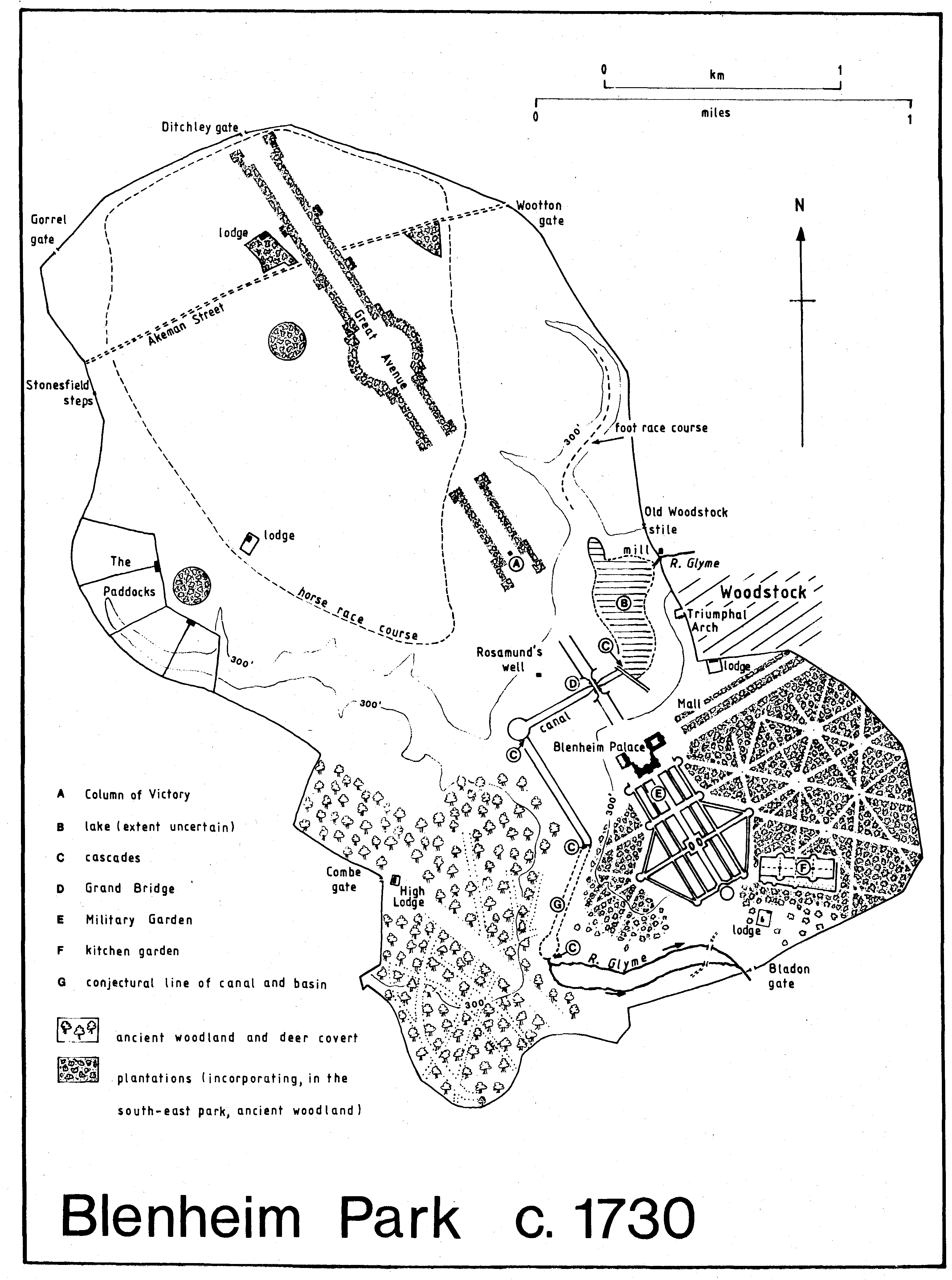
Blenheim Park c. 1730
The southern park in 1719 combined preserved forest trees with new plantings in avenues and circuses, some of the avenues radiating from viewpoints in the military garden. (fn. 92) The avenues west of the military garden were destroyed in the later 18th century but the pattern in the south-east survived into the 19th. (fn. 93) By 1876, however, after heavy felling of elms there in the mid 19th century, little of the formal layout could be discerned. (fn. 94) In the 1980s a vestigial avenue running west from near Eagle gate towards the kitchen garden survived from Wise's original design, (fn. 95) in which it had provided a vista from the south-eastern bastion of the Woodwork to the distant spire of Kidlington church.
The kitchen garden, which survives, was built in 1705-6. The chief walled area covered c. 7 a. within 14 ft. high bastioned walls; a smaller enclosure, later called a potagerie, lay on its south and east sides. The main walls were entirely of locally made brick on the south and east, and of stone lined with brick on the other sides. Two great stone basins, which survive, were part of the original plan; a heated wall for vines was incorporated before 1732. (fn. 96) In 1716, when the plants were fully established, Vanbrugh judged it the finest kitchen garden in Europe. (fn. 97) The Palladian gateway forming the western entrance was inserted by Sir William Chambers c. 1770. (fn. 98) The gardener's house near the south-west corner is of the later 18th century.
The earliest plans for the park included schemes to canalize the river Glyme, inserting rectangular and polygonal basins with islands. (fn. 99) Vanbrugh's design for the Grand Bridge, accepted by 1706, (fn. 1) seems to have assumed the existence of three watercourses, a broad one to pass under the great central arch, and smaller canals under the two flanking arches. Vanbrugh also planned to form lakes in the northern and southern valleys, creating what the duchess disparaged as 'a great sea round the house'; in 1716, before Vanbrugh left Blenheim, doubts were expressed about the porosity of the valley floor, and the duchess, who preferred a simple canal, feared that the 'beautiful green meadows ... will be all over in spots of dirty, stinking water'. (fn. 2)
In 1722 she engaged William Townesend and Bartholomew Peisley to finish the bridge and build canals to a revised design by the engineer, Col. John Armstrong: a straight canal 1,840 ft. long and 100 ft. wide, flanked on the north by a narrow channel to a water-engine and on the south by a channel for surplus water, was to pass under the bridge and terminate on the west in a circular basin 300 ft. wide. (fn. 3) The contract, completed by 1723, (fn. 4) was the first stage of a more elaborate scheme carried out in the next few years. The lower of the two causeways to the former manor house was built up to create a large, shallow lake, (fn. 5) filling the valley from Old Woodstock mill and terminating in a cascade of twelve stone steps leading to Armstrong's canal and basin; both lake and cascade were complete by 1724. (fn. 6) In 1724 Townesend and Peisley were contracted to build another canal 3,250 ft. long and 100 ft. wide in the southern valley, beginning with a cascade at the basin, another where the canal changed direction, and a third where a large oval basin at the south end overflowed into the old river. The contract, which included other conduits and reshaping many of the valley slopes, was for over £3,000; (fn. 7) it was completed by 1725 when a hundred men were landscaping the valley near Rosamund's Well. (fn. 8) The duchess boasted that the idea of the upper cascade, 'the finest and largest ever made', had never occurred to Vanbrugh, (fn. 9) although an early plan, probably representing Vanbrugh's ideas, (fn. 10) shows lakes linked by a canal beneath the bridge, and a dam (with presumably some form of waterfall) at the causeway. The upper lake continued to cause problems: in 1731 Hawksmoor noted that the cascade 'does not play', and in 1738 it was choked with weeds. (fn. 11)
Vanbrugh's design for the Grand Bridge, 'a monstrous bridge over a vast hollow', (fn. 12) prevailed over less ambitious schemes by Wren and others. (fn. 13) His intention was to maintain a view of the palace throughout the approach along the northern avenue, which required not only a long, high bridge but also the extensive reshaping of the valley sides to link them to the bridge by earthen causeways. The bridge, likened to the Rialto bridge in Venice, (fn. 14) comprised a central arch 100 ft. wide, flanked by smaller arches, and four corner towers. The whole structure was c. 400 ft. long and 50 ft. high, and would have been 80 ft. high if a proposed colonnaded superstructure had been built. (fn. 15) The bridge contained some 33 chambers: one large room was described sardonically by the duchess in 1716 as 'for a ball if there were occasion', (fn. 16) and others included a bathing place and a boat house. (fn. 17) The northern arch eventually incorporated an engine which pumped water to a cistern above the east gate of the palace. The engine, designed by John Aldersea, was first installed in an engine house in 1706, probably near the bridge, to provide water for a temporary cistern on the palace site, (fn. 18) and the whole system was replumbed in 1724, presumably after the bridge and cistern tower were completed. (fn. 19)
The bridge was not begun until 1708, and the central arch keyed in 1710. (fn. 20) When work was stopped in 1712 only its western façade seems to have been near completion, and it was not linked to the valley sides. (fn. 21) In 1716 Henry Wise again worked on the approach causeways, but did not complete them. (fn. 22) In 1721 and 1722 William Townesend and Bartholomew Peisley contracted to complete the bridge by matching the east side to the west (but omitting the frostwork panels); they were allowed to dig the required rubble from the slopes west of the southern causeway and from the site of the old manor house. In 1724-5 they put iron railings in both staircases and beneath the bridge, and paved between the towers and the quadrants. (fn. 23) By 1725 the landscaping of the valley had been completed to the duchess's satisfaction (fn. 24) but critics noted that the meagre canals emphasized the disproportionate scale of the bridge, which 'like the beggars at the old duchess's gate begs for a drop of water and is refused'. (fn. 25)
Vanbrugh's attempts to retain the ancient royal manor house were finally defeated by the duchess. (fn. 26) In 1708 the manor house was repaired and roofed, and a forge and curtain wall added; (fn. 27) it seems there were plans for Francis Godolphin, Lord Rialton, to live there, (fn. 28) and although further work was forbidden in 1709 the habitable part was reserved for a time for Samuel Travers, surveyor-general of Crown lands. (fn. 29) In 1713 Vanbrugh moved his belongings into the building, and his further improvements there in 1716, to 'make it just habitable', provoked the final breach with the duchess. (fn. 30) The manor house was pulled down in 1723, the site landscaped and turfed, and some material used in completing the bridge and causeway; masonry from the site was said to have been used as late as the 1760s to strengthen the base of the Grand Bridge in readiness for the new lake. (fn. 31)
In 1722 the duchess was planning to rebuild much of the circuit of park walls and include some perimeter gates and lodges. The section between the Triumphal Arch and Home Lodge, unusual for its use of shallow buttresses, dates from a rebuilding by Townesend and Peisley in 1723-4, and the remaining walls were allegedly begun in 1727 and finished in 1729; in the 1720s various internal walls were removed. Much of the perimeter wall conforms to a design of Townesend and Peisley for unbuttressed walls 8 ft. high and 2 ft. thick, with a canted coping of Headington stone. (fn. 32)
During the building of Blenheim the town gate remained the main entrance; a map of c. 1710 shows Bladon, Combe, Gorrel, and Wootton gates, and steps over the wall towards Stonesfield, (fn. 33) but Bladon gate was only a stile in 1738 when the duchess was proposing a simple carriage gate and the removal of an 'ugly house nearby'. (fn. 34) A gate and lodge at the northern entrance to the avenue was proposed in 1722, and Hawksmoor made several designs for Ditchley gate in 1724; (fn. 35) there seems to have been a lodge there in the 18th century, later rebuilt, (fn. 36) and the surviving gate piers are probably of the mid 18th century. The proposed main entrance to Blenheim, according to tradition, was to be at the east end of the Mall, but the duchess was unable to buy the necessary land. No gate had been built by 1719, when a cottage and garden blocked access to the avenue, and by 1731 the duchess had resolved 'never to come into the park that way'; (fn. 37) the offending cottage was still there in 1750 and there may have been no entrance at Hensington until the 1760s. (fn. 38) Instead the main entrance, designed by Hawksmoor in 1722 and later called Woodstock gate or the Triumphal Arch, replaced the town gate at the west end of Park Street; it did not face the street but was placed on the south side of a high-walled courtyard or 'esplanade'. The town's reported opposition may have been an attempt to preserve the medieval gateway. (fn. 39) The Triumphal Arch, of the Corinthian order, incorporated a small porter's lodge which was still in use in the mid 19th century; the two flanking doorways are thought to have been added later, perhaps removed from the formal gardens c. 1770. (fn. 40)
An inscription over the archway, recording its completion in 1723, refers to a pillar commemorating the duke's achievements, but at that date the Column of Victory was not begun. Hawksmoor made many designs for an obelisk, but in the end the column, built by Townesend at the southern end of the avenue between 1727 and 1731, was 'conducted' by Henry, Lord Herbert; Roger Morris was also concerned in its construction. The plinth bears lengthy inscriptions reciting the Acts bestowing the estate on the duke, together with a long panegyric composed by Henry St. John, Viscount Bolingbroke. (fn. 41) By 1728 the fluted Doric column was surmounted by a bronze statue of the duke in Roman costume, possibly from the workshop of Sir Henry Cheere; the monument is over 134 ft. high. (fn. 42)
Of the four keepers' lodges acquired with the estate only High Lodge is known to have been altered in the early years: although largely rebuilt in the later 17th century, it was heavily renovated in 1706 and a new wing added; the Marlboroughs used High Lodge until the palace was ready, and it was also used by friends and relatives, notably the duchess's mother, Frances Jennings. (fn. 43) North Lodge was at first reserved for Brigadier William Cadogan, Woodstock's M.P. from 1705 until 1716, although he probably rarely lived there. (fn. 44) Hensgrove Lodge was used by Henry Wise, and at the later Park Farm Francis, earl of Godolphin, for a time kept colts. (fn. 45) Before 1713 Vanbrugh occupied a house in the park, which 'properly belonged to the baily of the park'; (fn. 46) it was probably at the park gate, adjoining the west end of Chaucer's House, where a building called 'Sir John's house' was demolished to make way for the new Woodstock entrance in 1723. (fn. 47a) The demolition of the old park gate and adjacent buildings probably removed the meeting place of the Park Gate court, for in 1724 a new court house was built near the Triumphal Arch, probably on the site of the surviving Woodstock Lodge. (fn. 48a) Another building stood on the site of Home Lodge, presumably associated with an enclosure there called in 1719 the Warren; it was Wyatt's lodge in the 1720s, and later in the 18th century was occupied by the park bailiff. (fn. 49a) In 1707 Wise was preparing an ice-house, perhaps that on the east side of the lower park, blocked in 1946, or another presumed to be beneath Icehouse Clump, north of the lake. (fn. 50a)
The Column of Victory was probably the last major addition to the park during the lifetime of the duchess. Extensive works thought to have been carried out at Blenheim in the 1730s by Charles Bridgeman were in fact at the duchess's Wimbledon house. (fn. 51a) The 3rd duke, although said to have 'enjoyed Blenheim without making a single major alteration', (fn. 52a) began to extend the gardens, planting the slopes south-west of the palace with flowering shrubs. (fn. 53a) The 4th duke transformed the park with the aid of Lancelot Brown, who between 1764 and 1774 was paid over £21,500 for work at Blenheim. (fn. 54a) His achievement may be reconstructed partially from maps of c. 1764, 1772, and 1789 and from field evidence and later views. (fn. 55a) Much detail attributed to Brown may have been carried out later under the management of Benjamin Read (d. 1794), whom Brown had recommended as a gardener 'above all others in this kingdom, next to himself'. (fn. 56a) In 1787 the duke was still 'sticking up twelve trees here and thirteen there', (fn. 57a) and he continued to alter the park and gardens.
Brown's boldest innovation was to create the great lake, obliterating Armstrong's canals and the existing lake by damming the southern valley at the point where the canalized river turned sharply eastwards. The cascade there was presumably unfinished in 1770 when Walpole criticized it as 'not stately enough', but it was soon noted as the most spectacular feature of the pleasure grounds. (fn. 58a) The flooding of the lower chambers of the bridge was prepared by casing the walls, (fn. 59a) and it was presumably then that the water-engine was removed from the north arch, first to Queen Elizabeth Island, then to the weir near the cascade, and finally, by the early 19th century to Old Woodstock mill. (fn. 60a) Queen Elizabeth Island, part of the medieval causeway and former lake dam preserved, perhaps unexpectedly, when the new lake filled, was planted with trees at an early stage; (fn. 61a) it was smaller before the water level was reduced in the late 19th century. (fn. 62a)
Below the cascade further canalization of the river was possible when the duke acquired the north part of Bladon parish at inclosure in 1767, bringing the whole lower Glyme into the park. (fn. 63a) The river was widened, deepened, and in places rechannelled, and dammed by a long side-cut embankment near Lince Bridge. Below New Bridge the river widened into a lake before circling the wooded Lince and falling over another cascade into the river Evenlode. New Bridge was built to designs by Sir William Chambers in 1772-3; lead sphinxes on its corner piers were removed in the late 18th century and the piers redesigned by John Yenn. (fn. 64a) Lince Bridge and Seven Arches Bridge over the Glyme near Old Woodstock mill, are both plain structures, presumably of the later 18th century.
Brown's treatment of the water won approval, even from Walpole; (fn. 65a) the steep sides of the valley were transformed into 'the bold shores of a noble river', and the Grand Bridge lost its 'extravagance' and gained 'propriety'. (fn. 66a) Brown has been credited with changing the contours of the valley, but it seems that it was not until later that the 4th duke, to provide a view of the water from the palace, reshaped the whole length of the valley's rim from the forecourt to the Triumphal Arch. (fn. 67a)
Brown's intention was to create a unified 'naturalistic' landscape providing constantly changing views from a circuit of walks and carriage drives. Some of the formal elements of the original scheme were removed. The military garden was destroyed entirely and replaced by a wide lawn, and the great courtyard on the north was grassed over. Hahas were created in the southern park to enable a ferme ornée to occupy the area south of the lawn while protecting gardens to the east and west; other hahas in the northern park protected the perimeter belt of trees which Brown planted round most of the park. (fn. 68a) The great avenue and the Mall, the radiating avenues in Lower Park, and the ancient woodland of High Park were preserved, although some felling probably took place to create vistas, and Brown's winding carriage drives took no account of existing formal lines. Plantations in the northern park were preserved and Brown added others, notably Fourteen Acre Clump and clumps in the valleys north of the lake, while south of the palace the great lawn towards Bladon was framed by and interspersed with trees. His most intensive planting was along the lake, where the shape and texture of his surviving clumps are still apparent. (fn. 69a)
Brown introduced Gothic architectural features into the landscape. High Lodge was entirely rebuilt, probably in 1764 and presumably to Brown's design. (fn. 70a) It is a castellated stone building, with a three-storeyed central tower, flanking wings, and two-light windows: it was evidently built as a folly to be seen at a distance, and is flimsy in detail and structure. Other designs by Brown (fn. 71a) included one for a granary and cart house, usually associated with Park Farm, although it may not have been built. (fn. 72a) A medieval gateway removed by the duke from the site of Eynsham abbey 'for some business at Blenheim' has not been traced. (fn. 73a) In general the 4th duke seems to have favoured the neoClassical style of Chambers for buildings in the park and gardens.
By the late 1760s Brown had already formed the lake and laid out the grounds. (fn. 74a) The park was further enlarged by bringing into it land north of Bladon village and, before 1789, land near Combe gate. (fn. 75a) Thus by the later 18th century the circuit of park walls was much on its present lines, and most of the surviving gates established. (fn. 76a) Hensington gate, described as new in one of Brown's sketches, (fn. 77a) incorporates piers designed by Hawksmoor for Wise's formal garden, surmounted by vases by Grinling Gibbons; the piers and railings of the curved flanking arms are also of the early 18th century. (fn. 78a) Ditchley gate and lodge were redesigned by John Yenn in 1781, (fn. 79a) but his scheme may not have been carried out: the surviving piers are probably earlier and the lodge much later. Eagle gate, so called by 1750, (fn. 80a) perhaps in reference to associated statuary, was later rebuilt with plain piers. By 1789 Combe gate (then called Combe Green gate) was established, and a lodge built there by 1806; another Combe gate further north, also established by 1789, was later blocked. (fn. 81a) When the wall near Bladon was moved southwards a new gate was made and an adjacent village house became Bladon Lodge. (fn. 82a)
Within the park Home Lodge was rebuilt, possibly in the 1780s when it was given furniture from the palace; it replaced a house occupied by the park bailiff, which was said to have been demolished in 1765. (fn. 83a) The house, occupied in modern times by the duke's agent, was extended at the rear in the late 19th century. (fn. 84a) It is sometimes called China Corner because in 1796 a cruciform china gallery was built south of Home Lodge to display porcelain offered to the duke in 1793 by Samuel Spalding in return for accommodation as caretaker of the collection; the building was demolished c. 1840 and the collection displayed thereafter in the palace. (fn. 85a) North Lodge, used as a keeper's lodge during the 18th century, was altered and a large ancient wing demolished, allegedly in 1788; its surviving front is of that period. (fn. 86a) Fishery Cottage, at the north end of the lake, also contains 18th- century work; in the early 19th century water- fowl were bred there by the duke's fisherman. (fn. 87a) Lince Lodge in the south-west is a Georgian building with late 19th-century additions, presumably built after the area was taken into the park in 1767; it may have been associated with a pheasantry established in the Lince in the 1790s. (fn. 88a) The heavy planting of the Lince, sometimes attributed to Brown, seems to have occurred after 1789, although the riverside walk from New Bridge to the lower cascade was established and planted earlier. (fn. 89a)
Park Farm was used in the 18th century not only as farm buildings but as a menagerie for exotic birds and beasts, including tigers; by the late 18th century and until the mid 19th it was called the Dog Kennel and presumably housed the duke's hounds. (fn. 90a) It was rebuilt as a large farmery, apparently in the 1840s, and added to in the 1870s. (fn. 91a) In the later 18th century the northern park was farmed chiefly from buildings at Furze Platt, said to have been established in 1751, although most of the surviving buildings are later. (fn. 92a) The farmland, separately administered from most of the park, was usually held with land outside the walls in Hanborough and Bladon. It was mostly pasture but more land was ploughed in the early 19th century when a large enclosure in the north-west corner was added to existing arable on the eastern edge near Furze Platt. (fn. 93a)
The design of the 4th duke's pleasure grounds seems to have owed little to Brown's ideas. Although Wise's flower garden on the east front was turned into a lawn the duke soon created another formal flower garden further south, approached by winding paths through shrubberies. (fn. 94a) The new flower garden, described in 1787 as 'a conception of Paradise', was a large oval with geometrical beds and radiating paths 'after the plan of Madame de Pompadour at Versailles'. (fn. 95a) In it stood a temple of Flora, probably that now in the western gardens; it may have been designed by Chambers in 1772. (fn. 96a) Chambers's Palladian gateway of c. 1770 in the kitchen garden was evidently meant to decorate the pleasure gardens, and in 1789 the small Corinthian temple of Health, designed by John Yenn and celebrating George III's recovery from illness, was built north of the flower garden. (fn. 97a) Before the 4th duke's death in 1817 the flower garden was redesigned to accommodate an aviary, a semi-circular construction of wood and wire designed by Henry Hakewill and acquired by the duke in 1812 under the will of Harriet, Lady Reade, of Shipton-under- Wychwood; it was set up around the temple of Flora. (fn. 98a) A new flower garden 'arranged in twenty oval beds' was then created outside the east front of the palace. (fn. 99a)
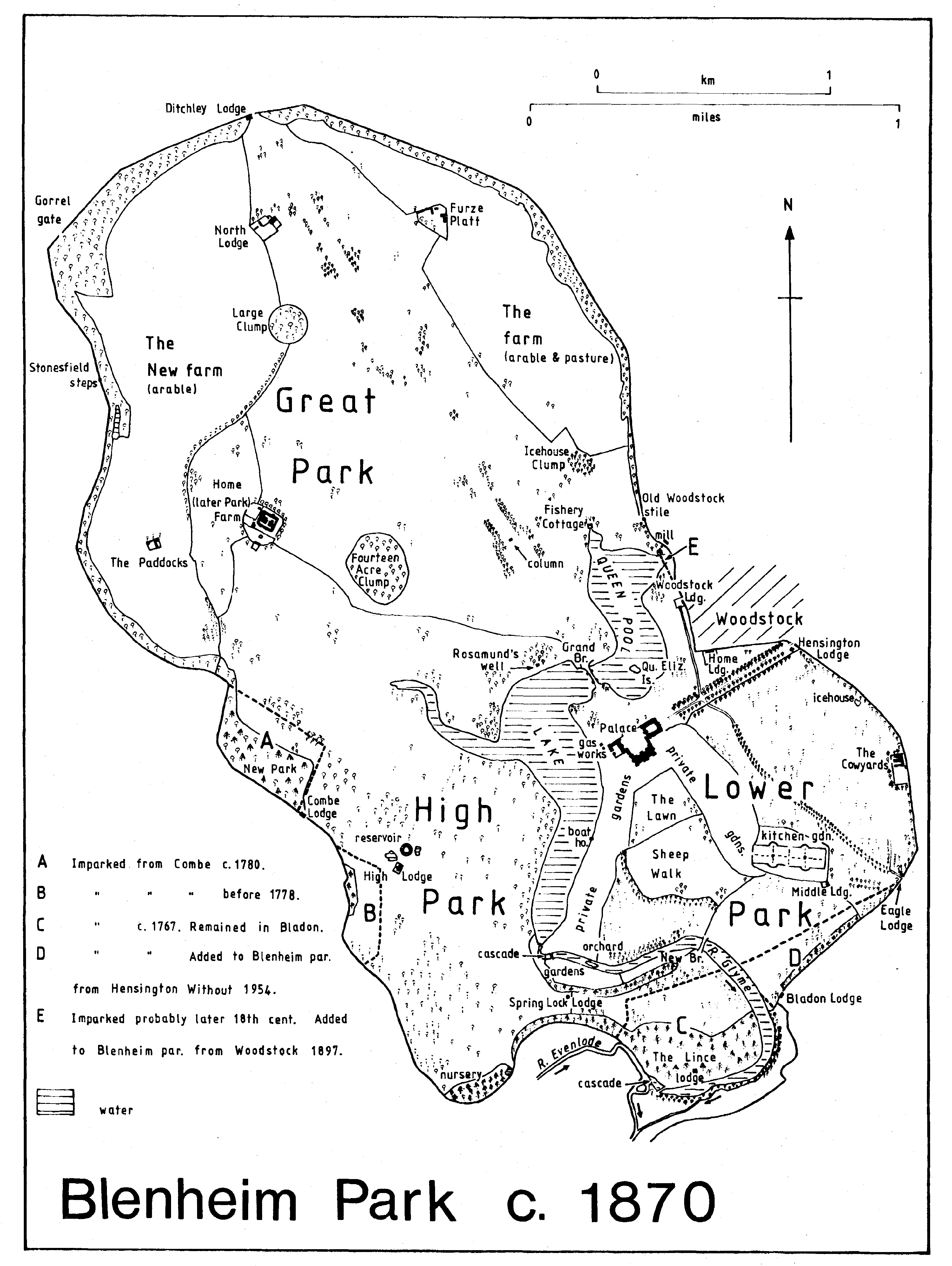
Blenheim Park c. 1870
The pleasure grounds on the west (fn. 1a) comprised plantations and shrubberies on lawns between the palace and the cascade; part of the ground was terraced, and there were statues and buildings, notably the surviving Ionic temple of Diana by Sir William Chambers. By 1789 a new garden on the far side of the river was reached by a 'Chinese bridge of mean effect' immediately below the cascade; (fn. 2a) the bridge was probably replaced by the surviving light iron bridge, sometimes called the Swiss Bridge, in the 1820s. The new garden contained the Newfound Well, a mineral spring feeding a decorative basin, and also the Bernini fountain, a gift to the 1st duke from the Spanish ambassador at the Vatican, set up by Chambers in 1774; it was removed to its present position on the water-terrace c. 1930. (fn. 3a) From the new garden in 1789 a path climbed the high ground west of the cascade, passing 'grottoes', presumably the rocks placed by Capability Brown as a background to the cascade, (fn. 4a) and returning over an iron bridge, presumably on the site of the later iron bridge at the south end of the lake. The pleasure grounds on the east and west were linked by a rural path through the ferme ornée, known as the Sheep Walk, where there was a rustic Shepherd's Cot and a flock of over a thousand pedigree sheep. Before 1817 the present sunk fence was inserted between the kitchen garden and New Bridge, and the path across the Sheep Walk closed. (fn. 5a) Visitors were particularly impressed by the scale of the gardens: 50 men were employed there in the 1780s, and another 100 or more in the park. (fn. 6a) Even in 1827, when the park was fairly neglected, 40 men were employed in mowing the lawns. (fn. 7a)
Between 1817 and his death in 1840 the 5th duke, 'gardening and', (fn. 8a) worked to create the finest botanical and flower garden in England, (fn. 9a) despite his financial circumstances. While criticized for transforming the 'rich draperies' of Brown's design into a 'harlequin jacket of little clumps and beds', he won praise for his outstanding rock garden and arboretum. (fn. 10a) In 1818 his son brought an action to prevent tree felling at Blenheim for profit, but tree losses continued and visitors noted the neglected lake, dam, and cascade. (fn. 11a) From his gardens at Whiteknights (in Reading, Berks.) the duke brought a vast collection of American plants. (fn. 12a) In the eastern garden near the aviary he created an arboretum, shrubbery, and pond. In the western garden, which he closed to the public, he laid out new areas, including the arcade flower garden outside the west front of the palace, the Chinese garden, the New Holland or Botany Bay garden, and rose and dahlia gardens. The rock garden above the cascade was probably enlarged; its enclosure, formed by tall standing stones, was entered past a pivoted boulder, moveable at the touch of a spring, a feature recalled in the name of the nearby Spring Lock Lodge. Below the cascade an island in the river was brought into the gardens. There was a Swiss Cottage above the rock garden for the watchman of the private gardens, and other structures included Chinese and Druids' temples, an Eskimo hut, rustic pavilions, and a grotto, presumably that surviving near the lake shore. (fn. 13a)
The 7th duke before 1860 laid out an Italian garden on the east front (fn. 14a) and a circular rosary, with radiating paths and a central fountain, on the site of the former Chinese temple. (fn. 15a) The surviving rosary was restored by the 11th duke on the same site. (fn. 16a) Before 1876 (fn. 17a) features such as the Eskimo hut were removed, and additions included a large fountain north-east of the cascade and an enclosure for kangaroos and emus east of the rose garden. The boathouse built in 1888 replaced an earlier boathouse further south. (fn. 18a) The exedra of yew and box, called in the 19th century the Roundabout, was established on the site of the aviary before 1876; its group of marble terms were removed there from the great hall in the mid 20th century. (fn. 19a) An eaglery and pheasantry near the exedra in 1876 were removed before 1898. By then features such as the pavilion in the arcade flower garden had been demolished, and the area outside the west front was a sunken lawn with trees and shrubs. (fn. 20a) Although some elements of the 5th duke's elaborate private gardens were preserved in the late 19th century, (fn. 21a) the parts near the cascade later became derelict and of the rest only a few exotic trees survive. (fn. 22a)
By 1841 there were peripheral lodges at Woodstock, Ditchley, Combe, and Bladon gates, and Old Woodstock stile, and the chief lodges within the park were Home, North, High, and Lince lodges. Staff were also housed at Fishery Cottage, Swiss Cottage in the private gardens, and in cottages at the aviary, the kitchen garden, and the nearby timber yard. Farm workers were at Furze Platt and Park Farm (the Kennel). (fn. 23a) Spring Lock Lodge was built in the 1840s, (fn. 24a) Middle and Eagle lodges before 1863, (fn. 25a) and Hensington Lodge, designed by F. B. Osborn, in 1876-7. (fn. 26a) Ditchley Lodge was rebuilt closer to the gate before 1863. (fn. 27a) Woodstock Lodge, so called by 1863, was rebuilt in 1887, and Bladon Lodge much restored in 1888. (fn. 28a) The Bothy, north-west of the kitchen garden, was built in the late 19th century. The 6th duke, in addition to rebuilding Park Farm, may have been responsible for the Cowyards in Lower Park, established before 1863 and further extended in the later 19th century; (fn. 29a) an Act of 1840 empowered him to sell trees to raise money for repairs, and the area around the Cowyards began to be denuded in that period. (fn. 30a) In the 1863 the chief arable area was in the north-west (c. 290 a.) and there was other arable near Furze Platt. (fn. 31a) In 1881 the tenant of Park Farm (then called Home Farm) was farming 1,200 a. and employing over 30 labourers. (fn. 32a) In the later 19th century much of the southern park (c. 300 a.) was pasture worked from the duke's Home Farm in Bladon. (fn. 33a)
After inheriting Blenheim in 1892 the 9th duke dredged the lake (fn. 34a) and later transformed the park and gardens. The Italian garden on the east front was entirely redesigned in 1908-10 by Achille Duchêne, with paths of crushed brick, topiary, and box hedging in arabesques around an earlier gilded fountain by Waldo Story. (fn. 35a) Between 1925 and 1930 Duchêne and the 9th duke built elaborate water terraces on the west front, comprising ponds, fountains, and statuary, including the restored Bernini fountain; the duke insisted on using Rosamund's well for the water, which was piped beneath the whole length of the southern lake to the engine house at the cascade, whence it was pumped back to the palace. (fn. 36a) In addition to restoring the northern and eastern avenues, the duke planted trees throughout the park, putting in nearly half a million between 1893 and 1919. Some of his belts and clumps alternated with Capability Brown's plantings, but he introduced coloured foliage, particularly copper beech, and in general created a more densely wooded scene than Brown's. (fn. 37a) His most notable clumps are on the east side of the river below New Bridge, in the valleys north of Fishery Cottage and towards Combe gate, and on the high ground of the northern park.
From the 1950s the 10th duke transformed the gardens on the east side of the great lawn, creating new shrubberies, rockeries, and pathways. (fn. 38a) Large areas of the park had been converted temporarily to arable during the First World War, (fn. 39a) and much of the northern park and parts of the southern were later turned to arable rotation land. Mainly treeless pasture was preserved in the south-eastern park for a stud farm established at the Cowyards by the 11th duke. In addition to the large areas of woodland maintained for game there was extensive planting of conifers for commercial purposes from the 1950s. Other new features of the park include tourist attractions such as a garden centre, a model railway, and recreation grounds provided for local people near Old Woodstock and Bladon. After the large-scale destruction of trees by Dutch Elm and Beech Bark disease in the 1970s a long-term plan was devised to balance the varied and sometimes conflicting uses of the park while preserving or restoring the chief elements of its historic landscape. (fn. 40a)