A History of the County of Oxford: Volume 4, the City of Oxford. Originally published by Victoria County History, London, 1979.
This free content was digitised by double rekeying. All rights reserved.
Eleanor Chance, Christina Colvin, Janet Cooper, C J Day, T G Hassall, Mary Jessup, Nesta Selwyn, 'Street-Names', in A History of the County of Oxford: Volume 4, the City of Oxford, ed. Alan Crossley, C R Elrington (London, 1979), British History Online https://www.british-history.ac.uk/vch/oxon/vol4/pp475-477 [accessed 30 April 2025].
Eleanor Chance, Christina Colvin, Janet Cooper, C J Day, T G Hassall, Mary Jessup, Nesta Selwyn, 'Street-Names', in A History of the County of Oxford: Volume 4, the City of Oxford. Edited by Alan Crossley, C R Elrington (London, 1979), British History Online, accessed April 30, 2025, https://www.british-history.ac.uk/vch/oxon/vol4/pp475-477.
Eleanor Chance, Christina Colvin, Janet Cooper, C J Day, T G Hassall, Mary Jessup, Nesta Selwyn. "Street-Names". A History of the County of Oxford: Volume 4, the City of Oxford. Ed. Alan Crossley, C R Elrington (London, 1979), British History Online. Web. 30 April 2025. https://www.british-history.ac.uk/vch/oxon/vol4/pp475-477.
In this section
STREET-NAMES
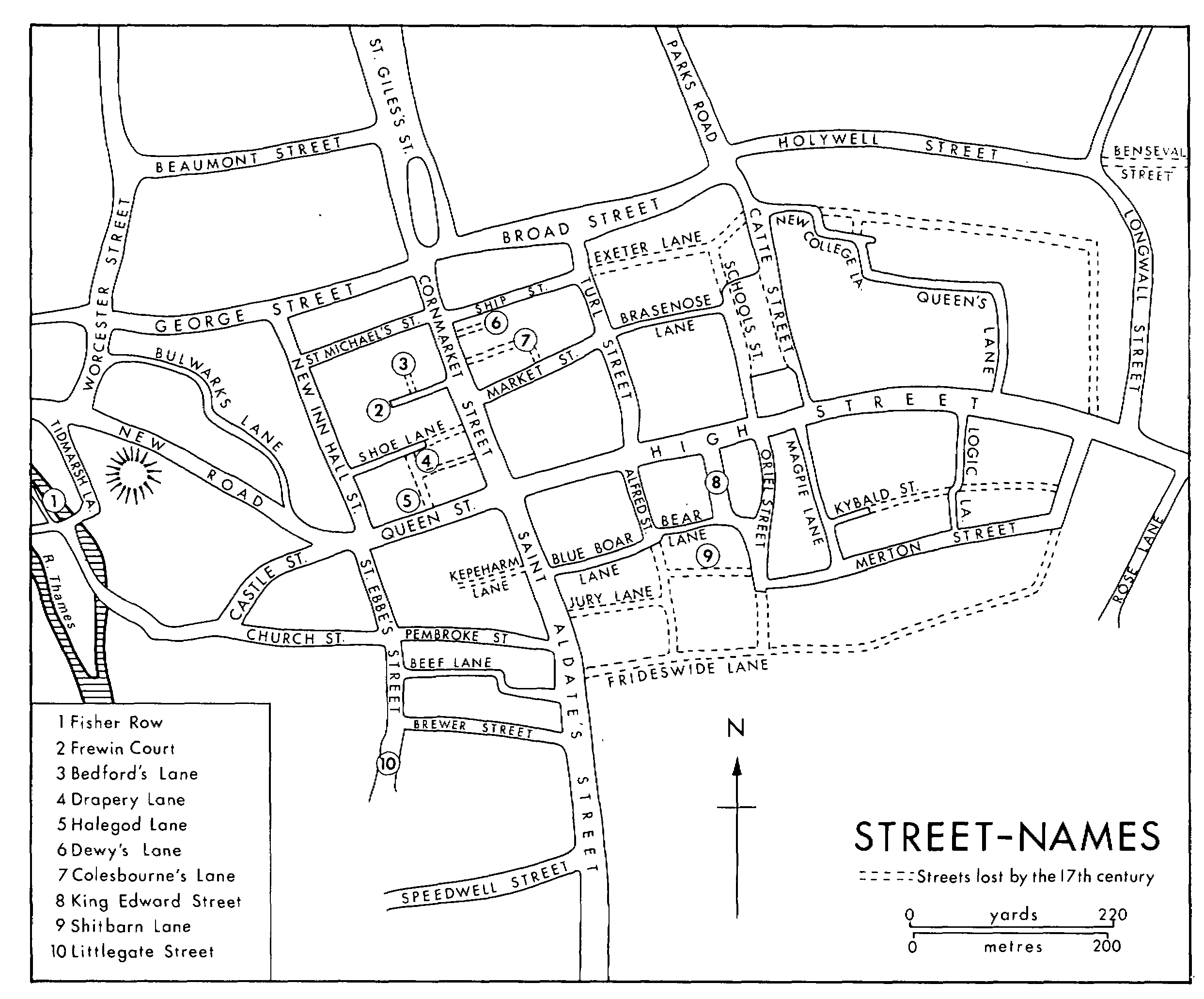
This gazetteer covers only the area of the medieval town. Streets are listed under their latest names. Except where otherwise stated the sources used were: H. E. Salter, The Historic Names of the Streets and Lanes of Oxford; Margaret Gelling, The Place-Names of Oxfordshire (E.P.N.S.), i. 37-44, which gives derivations; I. Taylor, Map of Oxford (1751); R. S. Hoggar, Plan of Oxford (1850).
Alfred Street (by 1850): earlier St. Edward's Lane (c. 1200 × c. 1210); Vine Hall Lane (1576); Bear Lane (mid 17th cent.).
Bear Lane (by 1814): perhaps Little Jewry (1388) and Jury Lane (1484). (fn. 1)
Beaumont Street: laid out c. 1820.
Beef Lane (by 1772): described c. 1620 as 'Beef Hall Lane anciently called King's Street'; Pembroke or Beef Lane (1772). Beef Hall was recorded between 1411 and 1550.
Blue Boar Street (1772): made in 1553 by William Tresham, sub-dean of Christ Church; Tresham's or New Lane (1614); Blue Boar Lane (mid 17th cent.); Bear Lane (1751).
Brasenose Lane (by 1850): St. Mildred's Lane (1335); Brasenose Lane (mid 17th cent.); Exeter College Lane (1751).
Brewer Street (20th cent.): Slaying Lane (1478, 1819); Brewer's Street (early 17th cent.); Slaughter or Brewer's Lane (1840); Brewer's Street (1850).
Broad Street (by 1751): Horsemonger Street (c. 1230); (fn. 2) Canditch (1325, (fn. 3) mid 17th cent.).
Bulwarks Lane (by 1772): Bullock's Lane (mid 17th cent., 1787).
Castle Street (by mid 17th cent.): earlier not distinguished from Queen Street.
Catte Street (by c. 1200): also recorded as Mousecatcher's Street (1442); Catherine Street (1850).
Church Street (by 1850): Friars Street (1490); Newmarket Street (1644); (fn. 4) St. Ebbe's Street (1751). Most of the street was destroyed by the building of the Westgate Centre in 1970, and the remnant was renamed Pennyfarthing Place.
Cornmarket Street (by 1751): North Street (1399); (fn. 5) Northgate Street (1379); (fn. 6) Cornmarket (east side) and Northgate Street (west side) (1772).
Fisher Row (mid 17th cent.): 'Waram' or bank of Thames (c. 1245, late 15th cent.). (fn. 7)
Frewin Court (by 1876): (fn. 8) Bodin's Lane (1405); Bridewell Lane (later 16th cent.). Richard Frewin lived there in 1726. (fn. 9)
George Street (by 1850): Irishman's Street (1251); Broken Hayes (1515); Thames Street (mid 17th cent.); George Lane (1772).
Hamel, The (St. Thomas's Parish): recorded from 1407.
High Street: East Street (c. 1195); (fn. 10) High St. from the early 13th century. The part in All Saints' parish was Butchers' Street c. 1218. (fn. 11) About 1180 and in 1438 the part by St. Mary's church was called St. Mary's Street. (fn. 12) The part from East Gate to Magdalen Bridge was called East Bridge Street (mid 17th cent.); Bridge Street (18th cent.). (fn. 13)
Street-names
Holywell Street (by 1772): no early name recorded.
King Edward Street: made in 1873.
Kybald Street (20th cent.): Kybald Street c. 1212. (fn. 14) Most of the street was closed in the later Middle Ages; the remnant was Grove Place in 1850. The part of the street between Logic Lane and the east end of Merton Street was called Harehall Lane or Nightingale Hall Lane at the time of its closure in 1447. (fn. 15)
Littlegate Street (by 1876): (fn. 16) South Street (1751); not distinguished from St. Ebbe's Street in 1772 or 1850.
Logic Lane (mid 17th cent.): 'Jaudewyne's lane' or Horseman Lane (1247, 1447); (fn. 17) Horsemill Lane (1298). (fn. 18) The mid-17th-century name may have applied only to the southern end, but by 1751 the whole lane was so called.
Longwall (by 1772): Long Walk (1751).
Magpie Lane (20th cent.): Gropecunt Lane (c. 1230); Grope or Grape Lane (later 13th cent.); Magpie Lane (mid 17th cent.); Grove Street (1850).
Market Street (by 1850): St. Mildred's Street (1180); Oldherde Street (c. 1261); (fn. 19) Chain or Cheyney Lane (c. 1330, 17th cent.); Jesus College Lane (early 17th cent.). The market was built in 1772.
Merton Street (by 1772): St. John's Street (c. 1200); John's Lane (1447); St. John the Baptist Street (mid 17th cent.). The western end, running north and south, was King Street (early 18th cent., 1776, and 1850); Coach and Horses Lane (1772). The whole street was King Street in 1751.
New Road: built c. 1770.
New College Lane (by 1772): Lincoln College or Thorald Lane (1648).
New Inn Hall Street (by 1850): North Bailey (1379); (fn. 20) Seven Deadly Sins Lane (1570); New Inn Lane (mid 17th cent.); New Inn Hall Lane (1797).
Oriel Street (by 1850): Schidyard Street (1210); St. Mary Hall Lane (1542, 1772).
Parks Road (by 1893): (fn. 21) Beaumont Street (c. 1250); (fn. 22) unnamed in 1751; Park Street (1850).
Pembroke Street (by 1850): Pennyfarthing Street (1349, 1772).
Queen Street (by 1850): Bailey or Great Bailey (c. 1260); Old Butcher Row (1657); Butcher Row (1772).
Queen's Lane (by 1772): western end was Thorald's corner (1231). (fn. 23) North and south section was Edmund Hall Lane (1751).
Rose Lane (by 1751): Trinity Lane (early 17th cent.).
St. Aldate's (by 1850): earlier divided into two by South Gate, the northern part was Jewry or Great Jewry (c. 1210); Fish Street (1342); South Street (1419). (fn. 24) The southern part was Southbridge Street (c. 1225); (fn. 25) Grandpont (1282, 17th cent.), but Fisher Street (1433); (fn. 26) Bridge Street (1751). The whole street was Fish Street in 1772.
St. Ebbe's Street (by 1850): Little Bailey (1261-2); (fn. 27) St. Peter's Street (1644); (fn. 28) St. Ebbe's Lane (1772).
St. Giles's Street (by 1325). (fn. 29)
St. Michael's Street (1900): (fn. 30) Wood Street (1405); Bocardo Lane (1548); not distinguished from New Inn Hall Street in 1751 or 1850.
St. Thomas's Street (by 1751): no early forms known.
Ship Street (by 1850): Summoner's Lane (1385); Summer Lane (1760), but St. Michael's Lane or Jesus Lane (mid 17th cent.); Ship Lane (1772).
Shoe Lane (by 1628): Sewy's Lane (c. 1225, (fn. 31) mid 17th cent.).
Speedwell Street (by 1850): Overhee Lane (1190, 1324); (fn. 32) Butterwick Lane (late 14th, early 15th cent.); (fn. 33) Mill Lane or Butterwick Lane (1427); Mill Lane (1639); Preacher Lane (mid 17th cent.).
Tidmarsh Lane (by 1956): Titmouse Lane (1751, 1850), but Titmarsh's Lane (1772). Richard Tidmarsh lived there in the later 17th century. (fn. 34)
Turl Street (by 1850): St. Mildred's Street (1363); Turl Gate Street (mid 17th cent.); in 1751 the part between Ship Street and Broad Street was the Turl, the rest Lincoln College Lane.
Worcester Street (by 1850): Stockwell Street (c. 1235, 1772), including the south end of Walton Street.
LOST STREETS. (fn. 35)
Bedford's Lane (1332 and 1587): Addington's Lane (1367); (fn. 36) ran north from Frewin Court.
Benseval Street (1295-1304): an eastern extension of Holywell Street, taken into Magdalen College Grove in the later 15th century.
Colesbourne's Lane (c. 1332): (fn. 37) Milward's Lane (early 15th cent.); ran from the north side of Market Street, through the cobblers' quarter into Cornmarket. (fn. 38)
Dewy's Lane (1259-60): (fn. 39) a private lane running east between nos. 25 and 26 Cornmarket.
Drapery Lane (1349): a private lane running west from Cornmarket.
Exeter Lane (mid 17th cent.): earlier Summoner's Lane (see Ship Street). An intra-mural road, continuing from the east end of Ship Street to Smith Gate; closed by extensions to the Bodleian Library in the 17th century. (fn. 40)
Frideswide's Lane (closed 1525-6): ran east from St. Aldate's Street to St. Frideswide's Priory, and was incorporated in Cardinal College.
Halegod Lane (1517): ran from Queen Street to Shoe Lane and was closed in the 16th century. (fn. 41)
Hamel, The (St. Aldate's) (1364, closed 1434): (fn. 42) by St. Aldate's churchyard.
Jury Lane (c. 1215-25): (fn. 43) Little Jewry (1325); Jury Lane (1376); Civil School Lane (1526). Closed c. 1545 and incorporated in Christ Church.
Kepeharm Lane (1325): Hinksey or Kepeharm Lane (1327). Closed by 1606 when the city was receiving rents for the site. (fn. 44) Ran west from St. Aldate's Street between Queen Street and Pembroke Street.
Rakke, The (1293, closed 1384): a pathway in St. Aldate's parish.
Schools Street (1275): part seems to have been called Beaufront (1259). (fn. 45) Shortened when the Bodleian Library was extended between 1610 and 1612, and incorporated in Radcliffe Square in 1737.
Shitbarn Lane (c. 1290): ran between Oriel Street and Alfred Street, south of Bear Lane. The western end was closed by 1306, the whole lane before 1397. (fn. 46)