A History of the County of Somerset: Volume 3. Originally published by Victoria County History, London, 1974.
This free content was digitised by double rekeying. All rights reserved.
A P Baggs, R J E Bush, Margaret Tomlinson, 'Parishes: Huish Episcopi', in A History of the County of Somerset: Volume 3, ed. R W Dunning (London, 1974), British History Online https://www.british-history.ac.uk/vch/som/vol3/pp1-13 [accessed 30 April 2025].
A P Baggs, R J E Bush, Margaret Tomlinson, 'Parishes: Huish Episcopi', in A History of the County of Somerset: Volume 3. Edited by R W Dunning (London, 1974), British History Online, accessed April 30, 2025, https://www.british-history.ac.uk/vch/som/vol3/pp1-13.
A P Baggs, R J E Bush, Margaret Tomlinson. "Parishes: Huish Episcopi". A History of the County of Somerset: Volume 3. Ed. R W Dunning (London, 1974), British History Online. Web. 30 April 2025. https://www.british-history.ac.uk/vch/som/vol3/pp1-13.
In this section
HUISH EPISCOPI
The parish of Huish Episcopi, normally known as Huish until the end of the 18th century, surrounds Langport on three sides. It lies principally in the hundred of Kingsbury (East), of which it forms a detached part. Portions of the parish extended into the neighbouring hundreds of Pitney and Somerton. (fn. 1) That part lying in Kingsbury (East) hundred measured 1,780 a. in 1841. (fn. 2) Just over 196 a. on King's Sedgemoor allotted to Huish in 1795 (fn. 3) lay in Whitley hundred, and an area round Paradise in the northeast was in Williton and Freemanors hundred. In 1861 the area of the whole parish was 2,282 a. (fn. 4) In 1885 the detached portion of the parish on King's Sedgemoor was transferred to High Ham, and Huish gained small detached parts of High Ham and Pitney. (fn. 5) In 1901 the area was 2,314 a. (fn. 6)
The parish is highly irregular in shape and its boundaries are dictated largely by natural features, modified by the effects of drainage and inclosure of the 'moors', and by the position of Langport. Much of the western boundary follows the river Parrett, flowing north to Common moor. The original division then probably followed the eastern edge of the 'moor', which was considered extraparochial and was subject to disputed ownership in 1637 and c. 1718. (fn. 7) The division of the 'moor' by agreement between Langport, Aller, and Huish, was made in 1797. (fn. 8) From the 'moor' the boundary runs up the scarp to Bowdens (Abovedowne alias Bowden in 1576) (fn. 9) through the hamlet of Combe, and then follows the contour round the scarp of Aller hill. The eastern limit of the parish follows the mill brook, the Wernestreme or Wernenstreme of the late-12th- or early-13th-century perambulation of High Ham, (fn. 10) as it flows south. East of Pound Farm, Wearne, however, the boundary takes in a triangular tract, perhaps the thirty strips of ploughland belonging, according to the same perambulation, to the king. (fn. 11) This land formed part of the manor of Pitney Wearne which was in the hands of the Crown until c. 1203. (fn. 12) The course of the boundary on Ham Down was established under inclosure in 1799. (fn. 13) The southern limit is the course of the Yeo and a stream, perhaps marking the earlier channel of either the Yeo or the Parrett, and known in the Middle Ages as Horsies Pyll, the rhine towards Muchelney, and Oldryver. (fn. 14) The southwestern boundary along Perry moor bank in Perry moor and then over rising ground, formerly the bishop's park, was established, at least as far as the park was concerned, by agreement between the bishop of Bath and Wells and the abbot of Muchelney in 1279. (fn. 15) The perambulation attached to a charter of Athelstan granting lands in Curry Rivel to Muchelney includes within the area of the modern parish of Drayton all that part of Huish south-west of the Parrett. The historical evidence suggests a forgery of the perambulation by Muchelney connected with the abbot's dispute over the bishop's park. (fn. 16)
South-west of the Parrett Huish Level lies on loam over clay and gravel in the flood plain, but further west the land rises to over 75 ft. In the extreme west over 50 a. were wooded at least until the early 19th century. (fn. 17) The centre of the parish, on gently undulating ground, then had a 'dry, good soil'. Further north, however, on Bowdens, and Aller hill above Combe and Wearne where the land rises to 300 ft., the soil was described as 'very thin and stony'. (fn. 18) At Pibsbury, in the south-east, near the 50 ft. contour, the fields are in many places uneven, the result of extensive quarrying for the lias which lies near the surface there. (fn. 19)
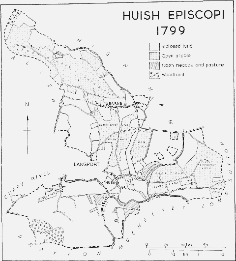
Huish Episcopi, 1799
There seem to have been Roman sites on the west bank of the Parrett and at Wearne. (fn. 20) The pattern of the later settlement seems to have been Saxon, and was dictated by the irregular terrain and by the stretches of marsh beside the rivers. Huish, Littleney, Pibsbury, and Combe were all established at the edge of this marsh. (fn. 21) Littleney, the 'little island' which gave its name to the bishop's estate in the parish at Domesday, provided a limited amount of arable a few feet above the level of the surrounding marsh. (fn. 22) By the early 14th century much of the marsh had been drained, and the settlement itself virtually deserted. (fn. 23) Huish, the 'homestead' or 'hide' settlement, (fn. 24) commanded a route to Langport and became the most important in the parish, acquiring the church, court-house, vicarage house, cross, and green. (fn. 25) Pibsbury, anciently Pibbesbyrig, (fn. 26) lay near a fordable point on the Yeo which, from the 15th century, was the loading place for local stone. (fn. 27) By the end of the 18th century if not before Pibsbury's houses stood in a neat cluster on the north side of the road a mile east of Huish church, with regular plots stretching behind them. The road there was known as Pibsbury Street in the 18th century, and may have formed some kind of defence against flooding. (fn. 28)
Two other hamlets, Combe and Wearne, lie in the northern part of the parish. Combe, on the edge of Poolmead, appears never to have been of much consequence. A mile to the east lies Wearne, the centre of the western part of Pitney Wearne manor. (fn. 29) It stretches for half a mile along a road on the southern slope of Bowdens. At Paradise, a name which first occurs in 1562, there is a subsidiary settlement. (fn. 30) In the 11th century there was a small arable holding at Wearne, possibly an area of warren forming part of the warren of Somerton. (fn. 31) There were two other settlements in the parish: the 'borough' of Southwick or Froglane, perhaps an extension of Littleney, which is treated elsewhere, (fn. 32) and the hamlet of Wagg. The second of these resulted from encroachments by cottagers on Wagg common, east of Huish village. Encroachment had started by the end of the 17th century, (fn. 33) and had become considerable by the end of the 18th century. (fn. 34)
Huish had three open arable fields in the Middle Ages, Court and Littleney fields and Huish Hill. (fn. 35) By 1755 they were known as Court, Inner, and Outer fields. (fn. 36) Pibsbury, which contained no demesne land, had three fields in 1650, (fn. 37) and four by 1755, known as Pibsbury, Pibsbury Farther, Horsey Furlong, and Lower Kinghill fields. (fn. 38) In 1799 they were known as Higher and Lower Pibsbury, Wagg, and Bottoms fields. (fn. 39) By the end of the 18th century Wearne was served by Higher and Lower Bowdens and Wearne Lower field. (fn. 40) Small-scale inclosure by agreement occurred on Aller hill, Ham Down, and Poolmead in the early 18th century, (fn. 41) part of Wagg common in 1786–7, (fn. 42) and Common moor in 1797. (fn. 43) Some 718 a. of arable was divided and allotted between 61 owners under an Award in 1799. (fn. 44) Under the same Award 58 a. of common meadow at Wagg and Pibhurst, the latter on the banks of the Yeo at Pibsbury, were divided. (fn. 45)
Main roads from Bridgwater, Somerton, and Ilchester to Langport pass through Huish. The Somerton road entered the parish via a ford across the mill brook until after 1823. (fn. 46) The present line from Brooklands House was adopted when the railway was constructed in 1906. The road was turnpiked in 1753. (fn. 47) The road from Ilchester, through Huish village, was turnpiked in 1792, and the Bridgwater road in 1824. The road from Brooklands House to Huish church was also adopted in 1824 in connexion with the new route south to Muchelney. (fn. 48)
There were two important bridges in the south of the parish. Huish bridge, over the Parrett below its confluence with the Yeo, carried a road from Huish village to Huish Level and Frog Lane. It was so named in 1581, (fn. 49) and was destroyed by the king's forces in 1646. (fn. 50) In 1791 it was described as of wood, standing on four stone piers. (fn. 51) The present bridge, called Black bridge, is of iron. Bicknell's bridge, formerly Bickling bridge, carries the road from Huish village to Muchelney. (fn. 52) It replaced a footbridge in 1829–30. (fn. 53) 'Stenebrugge' occurs in 1369, but its position is not known; (fn. 54) Wearne bridge and Pound bridge, found in 1666 and 1803, are probably names for the bridge, now a culvert, crossing the mill brook at Pound Farm. (fn. 55) There were at least two medieval fish weirs in the parish. 'Kingswere' was probably on the Parrett below Langport and was attached to a holding in Wearne by 1275–6; (fn. 56) the other was owned by the abbot of Muchelney and seems to have been across the Parrett on the Muchelney-Huish boundary. It occurs in 1353 and was still there in 1440, having a weir house near it in 1424. (fn. 57)
The present system of embankments and catchwaters was begun in 1795 with measures to improve the navigation of the Yeo. (fn. 58) Similar improvements on the Parrett threatened an increase in flooding, and the Long Sutton Catchwater drain, running along the northern bank of the Yeo was dug in 1836 and enlarged c. 1841. (fn. 59) It was equipped by 1971 with a pumping station.
The Yeovil-Durston branch of the Bristol and Exeter railway was constructed through the parish in 1853, and a station, known as Langport West, was built south-west of Langport Bridge. (fn. 60) The station and line were closed in 1964. Langport East station, partly in Huish parish, was built in 1906 on the link line between Castle Cary and Langport. It was closed to passengers in 1962 and to goods in 1964. (fn. 61)
Most of the agricultural holdings in the parish were small, and the surviving 17th- and early18th-century houses, mostly of lias and originally thatched, are generally of three-roomed ground plan. Pound Cottage has the parlour in a cross-wing, where there are two cruck trusses. In the hall, which is probably of late-medieval origin, there are parts of a further cruck truss. Pound Cottage, Huish, and Pound Farm, Wearne, have a cross-passage against the stack. During the 18th century several more sophisticated houses were built, notably Huish House. Of this only fragments, in the grounds of the late-19th-century house of the same name, remain. Wearne House, of 1729, has an unheated central room which is flanked by a larger room with gable stacks. The central room is lit by a vernacular version of a Venetian window with a five-centred middle unit. (fn. 62) A survivor of a more humble dwelling is Cornerways, Huish, built as three single-storeyed cottages in rubble and thatch, with brick stacks, in the late 18th or early 19th century. Langport began to extend its built-up area into Huish in the 19th century; Newtown occurs by 1845, the Avenue c. 1877. (fn. 63) Local Authority houses were built in Garden City between 1918 and 1929. (fn. 64) Similar houses were erected in Huish village after the Second World War, and private development took place north and north-west of the church in the early 1970s. (fn. 65)
In 1770 the New Inn was established in the parish. (fn. 66) The Rose and Crown, in Huish village, was so named by 1835, and the present building, with Gothic windows and a thatched roof, is contemporary. (fn. 67)
Huish seems, in the 19th century if not earlier, to have been a centre of popular entertainments including sports and revels, a ploughing match, and a flower show, the last of which still continued in 1971. (fn. 68) The parish proved a fruitful source for folk songs collected by Cecil Sharp. (fn. 69)
There were said to be 420 communicants at Huish and Langport together in 1548. (fn. 70) In 1563 there were 67 households in Huish. (fn. 71) By 1801 the population was 367, and in the next fifty years rose rapidly to 760, evidently owing in part to the development of dwellings at Newtown. (fn. 72) In the next half century the total fluctuated between 706 and 637, rose to 733 in 1911, fell in the next two decades, and was 945 in 1961. (fn. 73)
Manors and Other Estates.
In 1065 Edward the Confessor confirmed to Bishop Giso of Wells the villages of Lytelenige, Hiwisc, Cuma, and Pybbesbyrig. (fn. 74) The Domesday survey recorded Giso's holding only as Littelaneia, but its acreage implies that he also held the other properties. (fn. 75) By 1179, when a church had been built at Huish, the estate was known as the manor of HUISH. (fn. 76) Successive bishops of Bath and Wells held the manor until 1548, when Bishop Barlow was forced to surrender it to the Crown for the benefit of Edward Seymour, duke of Somerset. (fn. 77) The bishop recovered it in 1550, (fn. 78) and it continued to be part of the endowment of the bishopric of Bath and Wells until 1855, when ownership was transferred to the Ecclesiastical (later Church) Commissioners. In 1858 the estate measured over 977 a. Most of it was sold to the tenants in 1859–60, though the lordship was not included in any sale. (fn. 79) The Church Commissioners sold their last holding in 1952. (fn. 80)
In 1316 a piece of land in Southmoor was described as lying between 'the bishop's manor of la Hull' and 'the rhine towards Muchelney', and near 'the new close called Lytilnye'. (fn. 81) The 'manor' was probably the house and buildings from which the demesne was administered. Buildings on the demesne in 1302 included a hay barton and a cowshed by the park. (fn. 82) There were two barns by 1329, (fn. 83) and in 1351 land was described as lying between the grange of Hull and the bishop's park. (fn. 84) Repairs were made to the manor-house and kitchen in 1458–9, though by that time most of the land was divided and let. (fn. 85) There is no further trace of buildings, though pasture grounds included Hill Barton and Derehill, recalling the ancient name of the manor-house. (fn. 86) Park farm, the name of the largest single holding on the bishop's estate and embracing the presumed site of the park, included a field called Hill Park. (fn. 87)
By 1634 there was a court-house on the manor. (fn. 88) At least from that time it was let to a succession of tenants, and stood in a field, adjacent to a dovecot, sometimes known as Court Barton. (fn. 89) It was sold by the Ecclesiastical Commissioners in 1858, when it was divided into two dwellings. (fn. 90) It was subsequently known as Pound Farm, and in 1971 as Tanyard Cottage. It is a 16th- or early-17th-century structure with lias walls and a thatched roof. The internal walls appear to be later insertions and the Ham stone window surrounds are of various dates.
The manor of Pitney Plucknett or Pitney Wearne included a considerable amount of property in and near Wearne. Its descent has been traced elsewhere. (fn. 91) A farm opposite the present Pound Farm in Wearne was described as a capital messuage in 1692. (fn. 92) It was a building of the 17th century with threeroomed plan, internal chimney, and cross-passage. The floors and internal walls were removed early in the 20th century when it was converted for use as a barn.
In 1305 John Dammory died in possession of ⅓ hide of land in Wearne held of William le Venour. His heir was his son John, but the subsequent descent of the property has not been found. (fn. 93)
In 1305 Robert de St. Clare settled a small estate of 2 messuages, 2 virgates, 17 a. of meadow, and 6 a. of pasture in Long Sutton and Wearne on Reynold de St. Clare. (fn. 94) One third of this was given to Sibyl de St. Clare, and the rest was settled in 1360 on Richard, grandson of Sibyl, and on his wife Margaret, with remainder to William Bonville. (fn. 95) Bonville succeeded in 1362 to Richard's holding and in 1372 to Sibyl's. (fn. 96) He was one of the two free suitors to Huish hundred court in 1373. (fn. 97) The subsequent descent of the land has not been traced. (fn. 98)
The rectorial estate was held by successive archdeacons of Wells from the end of the 12th century. (fn. 99) It was let in 1547 for £28 a year. (fn. 100) The same rent was still payable in 1897. (fn. 101) In 1650 the whole estate was valued at £142, and comprised tithes and just over 74 a. of land, with 6 beast leazes or 6 a. of meadow in addition. (fn. 102) There were still 56 a. remaining in 1897. (fn. 103) Most of the tithes were commuted for corn rents worth £278 16s. in 1799, which in turn became a rent-charge of £185 1s. 2d. in 1914. (fn. 104) The remaining tithes, in Langport, were commuted to a rent-charge of £15 in 1840, (fn. 105) and tithes and moduses in Huish moor to a similar charge of £4 17s. 6d. in 1845. (fn. 106) A large proportion of the great tithes of Pitney also belonged to the parsonage of Huish by grant of Athelney abbey c. 1232. (fn. 107) These were commuted to corn rents worth £46 3s. 6½d. in 1797, and became a rent-charge of £32 16s. 4d. in 1876. (fn. 108)
The estate was normally held on lease from the archdeacons of Wells. Successive members of the Tucker family held it from 1624 at least until 1650. (fn. 109) From 1808 until 1897 the lessees were members of the King family, beginning with Walker King, bishop of Rochester, and ending with his son Edward, bishop of Lincoln. (fn. 110) In 1897 the latter sold the remainder of his lease of both tithes and glebe to the Ecclesiastical Commissioners, who by 1924 had disposed of the land. (fn. 111)
In 1650 the buildings of the estate included two thatched stone barns at the western end of the churchyard, one of five and the other of seven bays. (fn. 112) There were also other farm buildings, including some on the south side of Huish Street, opposite the church, the site of which is now occupied by the present vicarage house. (fn. 113) One of the two barns survived until 1883. (fn. 114)
Economic History.
Two recognizable parts of Huish were described in the Domesday survey: the estate of the bishop of Wells, then called Litelande or Littelaneia, which T.R.E. gelded for 2 hides, and the 2½-virgate holding at Wearne of Robert de Odburville. (fn. 115) Robert's holding had been waste in 1066; by 1086 it was worth 15s., there was arable for half a plough, worked by a bordar and a serf, and the demesne was stocked with 4 beasts and 15 sheep. The bishop's estate had land for 8 ploughs: one hide in demesne was worked by 2 serfs with 2 ploughs, and one hide was cultivated by 3 villeins and 6 bordars. There were 12 a. of meadow, 100 a. of pasture, and 20 a. of wood, but the only beast recorded was a riding-horse. The value of the bishop's holding was 40s. (fn. 116)
The size of the bishop's demesne does not seem to have altered significantly during the next five centuries: in 1521–2 the arable measured 149 a., the meadow 30¾ a., and the pasture about 107 a. (fn. 117) Drainage work, however, significantly increased the size of the cultivable land in the rest of the manor, and is reflected in the increase in the bishop's rent income: at least 86 a. of meadow and pasture ground, from which overland rents were payable, seem to have been recovered by 1302 in Newmead, Pibhurst, Middlemoor, Russehurst, Southwick, and Little Haymoor, now lying along the banks of the Yeo and Parrett. (fn. 118)
The demesne lands of the bishop's manor lay mostly in the south-west of the parish and by 1302 included a cluster of farm buildings around a house, a park, and the small settlement of Southwick, soon to be developed for a short while as a borough, presumably to attract business from the road at the western end of the Parrett crossing into Langport. The farm buildings of the demesne, housing a cowman, a parker, and other workers, included a cowshed and two barns. (fn. 119) By 1458 the demesne was entirely let, for £6 4s. 2d. (fn. 120) The arable lay mostly in large inclosures called Hill field (75 a.) and Court field (28 a.), with smaller units at Derehill (now Dairy hill) and Lytelnye field (later Little field), and small strips at Huish hill. Between 1504 and 1510 Hill field was divided into two and called Bishop's field. (fn. 121) Demesne meadows were let in 1458 for £5 10s. 1½d., and pasture for £14 15s. 10d. (fn. 122) These figures remained virtually unchanged at least until the mid 17th century. (fn. 123)
The bishop's park originated in a grant of free warren in 1257, (fn. 124) confirmed in 1280. (fn. 125) Shortly before this confirmation an agreement was made with the abbot of Muchelney whereby the bishop, who had built a 'wall' around his park to divide it from the abbot's park of Drayton, should also own a strip of land outside the wall, which the abbot's beasts could, nevertheless, graze. (fn. 126) Pasture in the park was let in the 15th century, though the area was still evidently fenced and gated. (fn. 127) Thickets and thorns from the park, suggesting lack of recent use, were sold in 1490–1, when oak and ash trees there were still reserved to the lord. (fn. 128) Sale of underwood and pasturage continued at least until 1566, (fn. 129) but by the mid 17th century the park had become the nucleus of the largest farm in the manor. (fn. 130)
The 'borough' of Southwick or Froglane, seems to have emerged very early in the 14th century. In 1302 it was referred to simply in connexion with overland pasture, (fn. 131) but in 1308 the Hospitallers of Buckland were in possession of a messuage and arable land 'in the vill of Langport in the street of Froggelane'. (fn. 132) By 1351 Southwick was the name of a separate jurisdiction within Huish hundred, and by 1458 it was described as a borough, with 31 burgesses paying a total rent of 32s. 10d. (fn. 133) There were still 31 burgages in 'Froglane in Sowthwyke' in 1566, (fn. 134) and the rent was still paid in 1592. (fn. 135) It seems clear, however, that any urban development had long since disappeared. Properties in Southwick and Froglane Close in 1611 were closes of pasture, (fn. 136) though the fiction of burgage lands continued as late as 1809. (fn. 137)
The tenants on the bishop's manor in 1458–9 comprised 3 freeholders, 4 virgaters, 16 halfvirgaters, 13 'ferdellers', and 4 cottagers. (fn. 138) Rents and other income from these tenants amounted to over £37, more than half the total income from the manor. Overland rents accounted for over £16, payments in lieu of works for over £10 8s., and assessed rents and traditional levies of Peter's Pence, 'faldeselver', church scot (churset), and 'larder' rents for over £9 9s. (fn. 139) Customary works were valued at only £7 13s. 3d. in 1362–3, and were then owed by 28 tenants. (fn. 140) It is not clear when works were last performed, though the final occasion was probably between 1302 (fn. 141) and 1329. (fn. 142) Perquisites of court included payment of chevage in 1492, (fn. 143) and a manumission was granted in 1450. (fn. 144)
Throughout the 16th and 17th centuries the income from the manor remained virtually stationary at just over £62. (fn. 145) The only means of increasing income significantly was to impose large entrance fines and heriots. This practice is particularly noticeable from 1554 to 1577, after the recovery of the estate from the Crown, and produced an income of £111 10s. 11¼d. in 1554–5 (fn. 146) and £177 15s. 1½d. in 1572–3. (fn. 147) By 1634 the rental was fixed at £56 5s. 'or there abouts', though between then and 1640 this amount was once exceeded but normally not quite achieved. (fn. 148) The income from the same sources was virtually the same in 1773. (fn. 149) Other small increases were temporarily made by selling underwood in the park, letting a horse-mill, or leasing fowling and fishing rights. These last rights continued to be let by the lord of the manor at least until the end of the 18th century. (fn. 150)
Among the early lessees of such minor items as the dovecot and fowling were members of the Gateryn family, which had been established in the parish by the end of the 14th century. (fn. 151) Thomas Gateryn (d. 1554) was a prosperous yeoman farmer, and one of the manorial freeholders. At his death he left oxen, cows, sheep, horses, pigs, and bees, growing corn, hay, and beans, and among other effects a boat with fishing and fowling gear. (fn. 152)
The pattern of land tenure in the bishop's manor c. 1634 was a roughly equal division between 38 copyholds and 35 properties let on leases for lives. The largest holding was known as the Park, worth £50 and let for £5. Most of the other farms were small. (fn. 153) The Park, later known as Park farm, measured nearly 105 a. by 1798, (fn. 154) and over 114 a. in 1799. (fn. 155) This had been overtaken in size by the farm of the Revd. Lawrence Heard Luxton, which in 1799 measured 164 a. (fn. 156) The third substantial holding was that of John Michell, the vicar, who had just over 91 a. in 34 separate units under one lease, and a further 27 a. under three other leases. (fn. 157) The remainder of the estate was held in small parcels and tenure was, with two small exceptions, by leases for three lives. Heriots were still payable on 38 holdings, the copyholds of 1634, normally of best beasts or best goods, often with an alternative cash payment and occasionally described as customary. There were also three cases of rents in kind: a fat pullet at Candlemas, a fat turkey, and a large pike at Lady Day. (fn. 158) Heriots remained payable on some leases until 1854. (fn. 159)
In comparison the Wearne part of Pitney Wearne manor, amounting to some 377 a. of arable, 87 a. of pasture, and 22 a. of meadow, with an annual rental of £34 16s. 10½d. in 1692, was then divided into 47 separate holdings, of which 38 were copyhold. Three were over 50 a. in extent, and one of these included the capital messuage. (fn. 160) By 1765 all but three houses on the whole estate had been enfranchised. (fn. 161) The property measured 588 a. in 1814, divided between 30 occupiers; there were four farms of over 50 a. (fn. 162)
It was thought in 1794 that inclosure would increase the value of the Wearne estate by at least a half. (fn. 163) Under an Award of 1799 nearly 718 a. of arable and just over 58 a. of meadow and pasture in the parish were inclosed, and 175 a. on King's Sedgemoor were also divided. (fn. 164) The size of farming units was comparatively little affected, but the rent roll of the bishop's manor rose to over £229 by 1832–3, an increase of over 250%. (fn. 165) In general, however, agricultural capital was diminishing, although in 1834 there were 110 labourers in the parish earning an average of £26 a year, and unemployment was rare. (fn. 166)
The substantial tenants on the bishop's manor were absentees. The Parks or Park farm, held by Ambrose Rhodes of Buckland Tout Saints (Devon) by 1798, and by George and Thomas Wolrige of Plymouth from 1801, (fn. 167) had no farm-house and even in 1886 only possessed a small group of buildings in Park Lane on the boundary with Drayton. (fn. 168) A farm-house for the present Merrick's farm, formerly known as Blakes and leased to the Luxtons of Weacombe in West Quantoxhead, was not built until after 1799, and by 1837 occupied a site once used for lime burning. (fn. 169) The third large holding, that of John Michell, the vicar, had buildings scattered around the estate but no central barton. The tenant lived in Huish House. Pound Farm in Wearne is the only survivor from the substantial holdings on Wearne manor. Two other farm-houses stood near the site of the former Langport cattle market, and a fourth was the former capital messuage opposite Pound Farm. (fn. 170)
Sales of reversions of leases on the bishop's manor began soon after 1850, shortly before the property was transferred to the Ecclesiastical Commissioners. (fn. 171) In 1858 974 a. were held on 110 separate leases for lives, and the average size of each holding was under 10 a. (fn. 172) There were, in consequence, few substantial farm buildings and much of the land, especially near Wearne, was divided into small orchards. Timber was worth only £152, much having been cut down since 1845. The Commissioners were encouraged to sell, and three of the largest units were disposed of in the next few years: 92 a. to Mrs. Julia Stuckey in 1859, 213 a. to Gen. Michell in 1860, and 111 a. comprising Park farm, to the tenants in 1866. (fn. 173) Most farming units, however, remained small, and as late as 1939 there were still 13 farms, 6 smallholdings, and 3 market gardens, besides the nurseries of Kelway and Son, formerly the Royal Nurseries, founded by James Kelway in 1851. (fn. 174) The main development in farming has been the continuing contraction of arable: by 1905 grassland, noted in the 18th century for the 'vast' amount of cattle fattened for the London market, (fn. 175) accounted for 1,368 a., compared with only 429 a. of arable. (fn. 176) A similar balance was retained in the mid 20th century.
Quarrying seems to have been the most important occupation in the parish after farming. Pibsbury quarries provided stone for repairing Bridgwater parish church in 1414–15, (fn. 177) and for a slipway at Bridgwater in 1488. (fn. 178) The stone was transported by river from a wharf near Pibsbury ford and the wharf continued in use at least until 1858. (fn. 179) Most of the later quarrying was indiscriminate and uneven fields bear witness to unsatisfactory reinstatement. (fn. 180) In 1858 there were three quarries: one had a large limekiln and lay near Tengore Lane. The others, further south-west, were held by Job Bradford and Mrs. Julia Stuckey. (fn. 181) By 1875 the firm of Bradford and Sons was working the quarry at Pibsbury and continued there until the early 1920s. (fn. 182) Limekilns had been built in various places by 1886 and quarries with limekilns had been opened in Frog Lane, operated with Merrick's farm. (fn. 183) Some of the kilns were in use in 1971.
Minor occupations in the parish in the 19th century included gloving, brewing, withy-growing, and the manufacture of straw hats. (fn. 184) A tannery was established in the parish by 1832 and gave its name to Tanyard Lane. (fn. 185) The business closed in the 1920s, but the premises were used in 1971 as a slaughter-house. (fn. 186)
There was a mill at Huish, let by the lord of the manor, by 1302. (fn. 187) Driven by a stream rising in High Ham, it stood north of Huish Street. A pair of millstones were purchased for it in 1503–4. (fn. 188) The mill was held by John Wetherell in 1565 and 1572, (fn. 189) by members of the Baker family c. 1634 and 1691, (fn. 190) and by the Edwards family in the 18th century. (fn. 191) Through the marriage of Mary Edwards to John Major c. 1798 it passed to Thomas Major, lessee by 1807. (fn. 192) Walter Wheller, who acquired the lease in 1852, subsequently bought the property, and by 1861 combined flour milling with beer retailing. (fn. 193) In 1867 a steam engine was installed to supplement water power and to drive a saw mill. (fn. 194) The mill closed between 1914 and 1919. (fn. 195) Part of the buildings, including a chimney, was still standing in 1971.
A field called Windmill Hill, on the scarp above Wearne, (fn. 196) contains the remains of a mill mound. James Courtenay owned a windmill in Wearne in 1585, and sailcloth was stolen from Col. Stawell's windmill at Wearne in 1664. (fn. 197) 'Miltoyt Way' in Wearne occurs in 1620 and may refer to this mill or to Bowdens mill, (fn. 198) the site of which is above Combe. (fn. 199) Bowden's mill was probably still in use in 1886; (fn. 200) Wearne windmill was abandoned by the end of the 18th century. (fn. 201) A third windmill stood at Pibsbury, at the junction of Higher Pibsbury Road (later Windmill Lane) with Kinshill Road. (fn. 202) It was built by William Wheller between 1797 and 1823 and cost him 'many hundreds of pounds'. (fn. 203) It was in use until shortly after 1897, (fn. 204) and part of it collapsed in 1915. (fn. 205) The remainder was dismantled in 1921. (fn. 206)
A horse-mill was erected on Huish manor in 1478, but its site is unknown. (fn. 207) It was still working in 1511, but the rent was unpaid in 1522 when it probably ceased production. (fn. 208)
Local Government.
In the 11th century the southern part of Huish parish, then known as Litelande or Littelaneia, was part of the bishop's fief. (fn. 209) By 1327 the bishop's estate of Huish was regarded as part of Kingsbury hundred for fiscal purposes though for judicial purposes it seems to have formed a separate jurisdiction. (fn. 210) Some of the more northerly parts of the parish were evidently reckoned as part of Pitney at the same time, and were therefore linked either with the hundred of Somerton or with Pitney hundred until the 19th century. (fn. 211)
Medieval records survive only for the bishop's part of the parish. There are hundred court rolls for Michaelmas 1351, Midsummer 1373, and Purification 1464; hallmote court rolls for Michaelmas 1351, Michaelmas 1369, Midsummer 1440, Purification 1464, Michaelmas 1539, and Hockday 1581; and records of both courts together for Purification 1343, Midsummer 1353, Midsummer 1361, and Midsummer 1424. (fn. 212) For the year from Michaelmas 1438 there is a roll of fifteen sessions of what is described as a hundred court. (fn. 213)
Huish hundred court, in existence by 1329, (fn. 214) evidently met at the four normal times in the year often, by the 15th century, on or near the date of the Kingsbury hundred court. (fn. 215) It was described as curia legalis, and retained characteristics of a hundred court by receiving tithing-pennies as late as 1545, although by 1521 it was evidently subservient to Kingsbury hundred (fn. 216) and the tithings of Huish and Combe mustered in the same hundred in 1539. (fn. 217) By 1351 the hundred court of Huish had jurisdiction over the tithings of Huish and Combe and the borough of Southwick. In that year tithingmen and bailiff presented cases of hue and cry wrongly raised, illegal brewing, unscoured watercourses, and trespass, and the jury for the whole court presented a defective roadway. (fn. 218) The courts for 1438–9 dealt mostly with pleas of debt. (fn. 219) Free tenants of the manor also appeared as suitors to this court. (fn. 220)
The jurisdiction of the hallmote court is less certain, and the practice of holding it with the hundred court probably early blurred the distinction between them. It was held at the four usual terms of the year at least until 1581. (fn. 221) When held separately from the hundred in 1351 it dealt with pleas of trespass and detention of goods, and recorded the entry of a tenant. (fn. 222) Its territorial jurisdiction cannot be defined. Other separate rolls record its concern for strays, scouring ditches, repair of the pinfold, and illegal inclosures. (fn. 223) By 1581, when the hundred had disappeared, it was also taking the suits of free tenants for the manor. (fn. 224) Both courts, recorded if not sitting together, covered matters of general economic concern, such as the control of sand digging, the repair of buildings, and licences for serfs to live outside the manor. (fn. 225)
There was a reeve and a parker by 1302, a bailiff of Southwick by 1351, as well as a bailiff for the hundred and tithingmen for Huish and Combe. (fn. 226) A bailiff and a reeve were charged jointly by the hundred and hallmote courts in 1343 to measure land in demesne and in severalty. (fn. 227) A hayward occurs in 1308. (fn. 228) At the Michaelmas hallmote in 1539 four men were presented for the office of reeve and three for the office of hayward. (fn. 229) A reeve and a hayward were presented for appointment at the Hockday hallmote in 1581. (fn. 230)
Wearne was presumably administered by the Pitney Plucknett or Pitney Wearne court during the Middle Ages, and was certainly included within its jurisdiction by the 16th century. (fn. 231) A tithingman and a hayward answered for Wearne twice a year at Pitney until 1770, and once a year until 1839. (fn. 232)
By the 18th century Huish manor was administered by courts baron and leet, the former sitting irregularly for entries and surrenders, the latter annually at least from 1758 until 1841. Its place of meeting by 1833 was the Langport Arms. (fn. 233) The court leet was concerned mainly with the regulation of agriculture. Its officers were a constable, two tithingmen, a hayward, all appointed in rotation, and from 1825 a bailiff. The two tithings were Huish with Pibsbury and Combe with Westover, presumably the equivalents of the medieval tithings of Huish and Combe.
The parish was divided into Pibsbury, Wearne, Combe, and Huish divisions for poor rates in the 18th century. (fn. 234) Until 1818 the open vestry appointed wardens, overseers, and surveyors, (fn. 235) and at its monthly meetings also administered the parish charities. (fn. 236) After 1818 the vestry, meeting less frequently, remained directly responsible for the repair of roads. Among its additional activities were the payment of an annual subscription for the use of Langport fire engine from 1798, the establishment of bounty payments for the destruction of sparrows from 1802, and the clearance of reeds in the river. (fn. 237)
By the end of the 17th century the overseers were supporting the poor either by direct cash grants, especially in cases of sickness or temporary unemployment, by payment of house rents, and by making allowances to those lodging paupers. (fn. 238) By 1703 there was a parish house, maintained and repaired regularly by the overseers until 1726. (fn. 239) By the end of the 18th century the vestry was making orders for gifts of food, clothing, and money for the poor, and arranged apprenticeships of pauper children. (fn. 240) In 1800 the increasing financial burden resulted in an order to the overseers to provide a workhouse where the poor might make stockings, and produce linen and linsey goods with material provided. (fn. 241) In 1805 the overseers were ordered to find a poorhouse and, having failed to do so, were in 1808 required to build one. Three additional dwellings adjacent to the house were ordered in 1812. (fn. 242) Payment of house rents ceased after 1808, but clothing and blankets were occasionally given and apprentices bound. Apprenticeships were often difficult to arrange and in 1802 the vestry ordered that in such cases boys should be bound to ships' masters and girls to linen- or woollen-manufacturers. (fn. 243) After 1814 no more payments were to be made to families refusing to live in the poorhouse, and from 1818 all receiving relief were to attend church every Sunday morning. A nurse and doctor were employed to treat the sick after 1818, (fn. 244) and the vestry was still capable of acts of generosity such as providing a tea kettle or an easy chair for two paupers. (fn. 245) The parish became part of the Langport poor-law union in 1836, (fn. 246) and two years later the poorhouses, two tenements each with three apartments, were sold. (fn. 247) The houses stood opposite the churchyard, south of the present church room, at least until 1933. (fn. 248)
Church.
There was a church at Huish by 1179, possession of which was then confirmed to Reynold FitzJocelin, bishop of Bath. (fn. 249) Both rectorial and vicarial glebe was later found in that part of the parish belonging to the bishops' manor, suggesting that the church was an episcopal foundation. By 1199 the church was granted to the archdeacon of Wells and his successors as part of the endowment of the prebend of Huish and Brent. (fn. 250) A vicarage was probably ordained c. 1232. (fn. 251) The benefice included the annexed chapelry of Langport from the end of the 14th century, if not ab origine; (fn. 252) the chapelry was severed from Huish from 1882. (fn. 253) In 1970 the living was united with the rectory of Pitney, and the incumbent of the benefice is styled a rector. (fn. 254)
Ecclesiastical connexions between Huish and Pitney were both ancient and close. In 1232, at the dedication of Huish church, perhaps after a fire (fn. 255) and possibly relating to the ordination of the vicarage, tithes belonging to Athelney abbey in Pitney were given to the vicar of Huish. (fn. 256) That Huish was in some sense the mother church of Pitney seems established by the fact that in the 18th and early 19th centuries the Pitney churchwardens contributed to the repair of Huish church tower. (fn. 257) Pitney inhabitants, in return, had burial rights at Huish at least in the early 17th century. (fn. 258)
The advowson of the vicarage belonged to successive archdeacons of Wells, who occasionally presented by proxy. (fn. 259) The Crown presented in 1381 and 1391 during vacancies in the archdeaconry, (fn. 260) and the bishop collated in 1413 after a simoniacal presentation. (fn. 261) The archdeacon of Wells is the patron of the united benefice.
The vicarage was valued in 1291 at £4 13s. 4d. (fn. 262) and at £14 10s. 5d. in 1535. (fn. 263) In 1650 it was said to be worth £50, (fn. 264) and there were plans to augment it in 1658. (fn. 265) By 1668 it was put at only £30. (fn. 266) The benefice was augmented in 1719 and 1826, and in 1831 brought in £210. (fn. 267) There were further augmentations of £200 each in 1833 and 1834. (fn. 268)
Tithes and oblations of the vicarage were worth £14 19s. 4d. in 1535. (fn. 269) The most valuable portion were the tithes of Langport, which were commuted to a rent-charge of £70 in 1840. (fn. 270) Most of the tithes from Huish were converted to corn rents in 1799, (fn. 271) and the remainder, with moduses, became a rentcharge of £2 5s. 6d. in 1846. (fn. 272) The corn rents were exchanged for a rent-charge of £53 17s. 2d. in 1914. (fn. 273)
Glebe lands of the vicarage were worth 9s. 4d. in 1535. (fn. 274) In 1636 they measured c. 7 a., and included a burgage in Langport and an acre in Langport field. (fn. 275) The burgage had been held since 1535 at the latest, when the vicar paid a rent to the duke of Richmond, then lord of Langport. (fn. 276) Neither property was held by the vicar in 1840. (fn. 277) About 49 a. of land in High Ham were purchased in 1723 with augmentation money, and a further 9 a. there in 1833, though only just over 49 a. were apparently held in 1838. (fn. 278) Just over 4 a. in Huish were bought from the rectory estate in 1842. (fn. 279) There were said to be 75 a. in 1883. (fn. 280) Nearly 49 a. in High Ham were sold in 1919, (fn. 281) leaving 11 a. by 1923 and c. 6 a. by 1927. (fn. 282) In 1948 the glebe was worth £29. (fn. 283)
In 1827 the vicarage house, 'in a sad state of dilapidation, wholly unfit for the residence of the spiritual person', was replaced by the present house, built on former rectorial glebe land a little to the north. (fn. 284) The former house, an L-shaped building, was apparently converted to piggeries, and has almost disappeared. (fn. 285) The present house, of local lias with a slate roof, incorporates fragments of medieval Ham stone masonry, brought either from the older building or more probably from Muchelney.
Thomas Combe (vicar 1413–16) was allowed in 1415 to farm his benefice for ten years in order to study, but his early departure from the parish must have affected the church comparatively little. (fn. 286) Most of his successors in the 15th century were graduates, and included two lawyers, Robert Hurst (vicar 1462–5), commissary-general of the diocese, and John Standerwick (vicar 1502–4), proctorgeneral in the consistory court at Wells, (fn. 287) neither of whom could have been regularly resident. Cananuel Bernard, appointed in 1625, was at the same time rector of Pitney. (fn. 288) His Huish living was probably sequestrated by 1656, but by 1650 he had been replaced by John Hillman. (fn. 289) Hillman was followed by John Jennings (1656), Charles Darby (1658), formerly vicar of Montacute, and John Bush (1659). (fn. 290) Bush apparently continued to serve Langport as 'curate' after Bernard was restored to the benefice in 1660, but was ejected two years later. (fn. 291)
During the 18th century the church, like much of the parish, was dominated by the Michell family: John Michell was vicar from 1722 to 1744; Thomas Michell was assistant curate for at least 14 years until 1768; another John was curate from 1777 until appointed vicar in 1780. He was a prebendary of Gloucester from 1798, but seems occasionally to have served the cure for his successor, Edward Willes, until 1809. Michell's son William also served Willes as curate in 1812. (fn. 292) Edward Willes himself, vicar 1802–24, was given the benefice by his father. He held West Camel at the same time, and lived at Bath; the duty was carried out entirely by assistant curates. (fn. 293) George Baily Tuson (vicar 1824– 39) lived ten miles from Huish until the new vicarage house was completed. (fn. 294) His successors were resident, though Joseph Stubbs (vicar 1882–1923) also held the living of Muchelney from 1902 until 1923. (fn. 295)
There is little evidence for the conduct of services before the 19th century, though a parochial chaplain was employed in 1463 and 1468, and a curate served the resident vicars in the 1530s and 1540s, in addition to chaplains at Langport. (fn. 296) In the late 18th century the benefice was served largely by assistant curates, most of the incumbents being non-resident. (fn. 297) In 1818 the churchwardens approached the bishop, apparently not for the first time, to ask for a service and sermon each Sunday, (fn. 298) and by 1827 there was 'full service' at both Huish and Langport, alternately morning and afternoon. (fn. 299) This remained the practice at least until 1870, with celebrations of the Holy Communion four times a year. (fn. 300) By 1884 two services were held each Sunday, with monthly celebrations. (fn. 301) On Census Sunday 1851 340 people attended the morning service, including 90 Sunday school pupils. (fn. 302)
A fraternity or brotherhood of Huish was active in 1543 and 1545. (fn. 303) A church house was rebuilt by the overseers, apparently the owners, in 1698–9; the new building was of timber on a stone sill, with a thatched roof. It was still standing in 1725. (fn. 304) The present church room, to the east of the church, was designed by C. H. Samson of Taunton, and opened in 1896. (fn. 305)
The church of the BLESSED VIRGIN MARY is of lias with Ham stone dressings and has a chancel with organ chamber, nave with north chapel, south aisle, north vestry, south porch, and west tower. The elaborately decorated south doorway is of the 12th century and apparently in situ, but no other part of the building can be attributed to such an early date. The stonework of the doorway is reddened, apparently by fire, which suggests that the rest of the early church may have been destroyed in that way. (fn. 306) The north wall of the nave is of the 13th century, perhaps the date of the reconstruction after the fire—a possibility which is strengthened by the recorded dedication of the church in 1232. (fn. 307) In the 14th century the church was enlarged by the rebuilding of the chancel and the addition of the north chapel and south porch. There was presumably a south transept at that date, completing the cruciform plan, but the surviving part of the south aisle which occupies its position is of the 15th century, as are also the nave windows and those in the east and west walls of the north chapel. The ornate west tower, (fn. 308) which is more than 100 ft. high, was added at the end of the 15th century and must have replaced one in a central position. Its removal allowed the nave to be extended eastwards and necessitated the rebuilding of the chancel and north and south transept arches. The rebuilding of the south transept may be contemporary with these changes. The south aisle was created early in the 16th century by extending the south transept westwards to meet the porch and by duplicating the south transept arch to form an arcade.
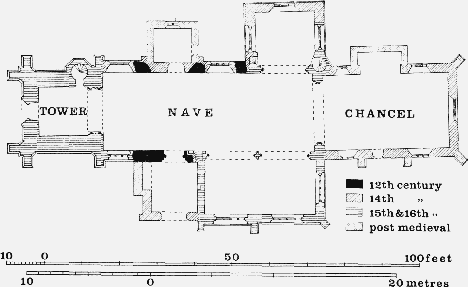
The Church of the Blessed Virgin Mary, Huish Episcopi
The chancel screen was removed in 1774 and at the same time a singing gallery was erected, probably at the west end. (fn. 309) The gallery was evidently removed before the church was restored by Benjamin Ferrey in 1872–3. Alterations included the removal of monuments from the chancel, re-roofing the nave and re-ceiling the south aisle, and the construction of the vestry. (fn. 310) The present tower screen was brought from Enmore church in 1873; (fn. 311) the organ chamber was added in 1892. The furniture includes a Perpendicular font, a Jacobean communion table, and a pulpit dated 1625. The glass in the east window of the south aisle, installed in 1899, was designed by Burne-Jones and made by William Morris.
There are eight bells: (i) and (ii) 1956, Taylor of Loughborough; (iii), (iv), and (v) 1902, Taylor of Loughborough; (vi) 1822, John Kingston of Bridgwater; (vii) 1620, Robert Austen I; (viii) 1650, Robert Austen II. (fn. 312) The plate includes a cup of c. 1689 with a cover of 1571; and a paten of 1700. (fn. 313) The registers begin in 1678, but there is a gap between 1727 and 1754. (fn. 314)
Nonconformity.
The Wesleyan minister of the Glastonbury and Somerton circuit was licensed to use James Sawtell's house in Wearne as a place of worship in 1825. (fn. 315) A building attached to James Lovibond's house was similarly licensed in 1828 in the name of the minister from South Petherton. (fn. 316) Methodists continued to meet in private houses, including that of Kesia Culliford in 1841, (fn. 317) until a chapel was licensed in 1847. (fn. 318) The position of this chapel has not been traced. No return has survived from Methodists for the 1851 census, and the cause may have lapsed. A new building, at the junction of the Avenue with the then road to Somerton, now known as Eastover, was opened in 1890. (fn. 319) It is of lias with stone dressings and a slate roof, and seats 150. (fn. 320) The building has been used since c. 1943 by a group of Christian Brethren, and is now known as the Gospel Hall. (fn. 321)
The tradition of nonconformist meetings in a barn at Newtown and at Combe (fn. 322) is partly borne out by a licence granted to the Independent minister of Somerton for use of a house in Newtown in 1845. (fn. 323)
Education.
In 1818 there were no schools in Huish, though it was thought that 'the poorer classes' were 'desirous of having the means of education'. (fn. 324) By 1826 there were Sunday schools at both Langport and Huish, teaching between them 80 boys and 80 girls. (fn. 325) Seven years later the parish had three small day-schools, catering for c. 28 children at the expense of their parents. (fn. 326) 'Several children' attended the National School, then said to be in Langport, but in fact in Huish parish, a few yards east of the Hanging Chapel. (fn. 327) This school was built in 1827, (fn. 328) and by 1833 housed both a day- and a Sunday-school for 80 children. It was supported by grant, subscriptions, and school pence, and had a lending library. (fn. 329) In 1846–7 the day-school had 67 boys and 78 girls, and the Sunday school 15 boys and 33 girls. (fn. 330) The school was closed c. 1876 when the Board Schools opened; the semi-detached teachers' houses, in 1971 private dwellings, form an irregular stone building, formerly thatched, in a plain Gothic style. (fn. 331) The schoolroom, after closure used as a Sunday school, stood in Bond's Pool Lane, a few yards north-west. It was sold c. 1897 and had been demolished by 1903. (fn. 332)
In 1874 a School Board was formed, and a building providing two rooms each for 100 boys, 100 girls, and 125 infants, and a residence for a teacher, was erected in 1876 on the east side of North Street, Langport, in the parish of Huish. (fn. 333) In 1903 there were 6 trained teachers and 3 pupil teachers; the boys were 'well taught', the girls 'doing well', and the infants 'fairly satisfactory'. The premises were also used for evening continuation classes and parish council meetings. (fn. 334)
The Board School, under the County Education Committee from 1903, became known as the Council Schools for the parishes of Langport and Huish Episcopi. (fn. 335) The boys' and girls' schools were merged in 1925, and in 1940 the senior pupils were transferred to a new building, north-east of Huish church. (fn. 336) This became known as Huish Episcopi Modern Secondary or County School in 1945. In 1969 it had 476 pupils. (fn. 337) The junior and infants' school, remaining in the original building, had 201 pupils in 1969. (fn. 338)
There are said to have been at least three private schools in Huish in the 19th century. A family school was held at Wagg in winter evenings in the 1850s; a dame's school at Pict's hill in the 1860s; and a girls' school kept by Miss Georgina Stone in 1897. (fn. 339)
Charities for the Poor.
Before 1666 small properties in Huish and a house in Langport were given in trust for the maintenance of Huish and Wearne bridges, and became known as the Bridge Land charity. By the beginning of the 19th century the income was added to the general rate income. (fn. 340) In 1840 Huish bridge, then a footbridge, was taken over by the Parrett Navigation Company, which replaced it by a wooden carriage bridge. Wearne bridge was subsequently converted into a culvert by the local highway authority. (fn. 341) The income of the charity therefore accumulated until, in 1894, after various local disputes over its application, a Scheme was established, under which £150 was given to rebuild Huish bridge and up to £100 to enlarge the churchyard. (fn. 342) The remaining income was to be 'applied for any public purpose approved by the Charity Commissioners for the benefit of the parishioners'. From 1897 until closure in 1933 the charity provided scholarships for Huish boys at Langport Grammar School; subsequently, and until 1944, financial assistance was given to Huish boys attending Huish's Grammar School, Taunton. (fn. 343) Since that time the charity contributed towards the cost of the recreation field, owned jointly by Huish and Langport. (fn. 344) In 1894 the real property of the charity was sold and the total income from investments amounted to £21 16s. a year. (fn. 345) The assets of the charity in 1965 amounted to £245 18s. 10d. investment shares. (fn. 346)
Interest received from a capital sum of £15 lent by the churchwardens for various purposes was occasionally paid by them to the second poor. Such payments were made in 1762, 1772, and 1783, but by 1786 the charity was lost. (fn. 347)
By will dated 1797 Martha Bond (d. 1797) bequeathed all money in her possession or at interest to be divided equally between the poor of Huish, Langport, and Aller. In 1801 the share of each parish, £141 19s. 1d., was invested, producing £7 15s. for each, distributed at Christmas to people chosen by the churchwardens (fn. 348) and submitted to the vestry. (fn. 349) In the early 19th century the money was divided annually among the second poor, numbering as many as 161 in 1837, each one receiving in that year 1s. (fn. 350)
Under a Scheme of 1919 a capital sum bequeathed under the will of Emma Tilley, dated 1917, was used to purchase £276 1s. 3d. stock. Half this sum, known as the Tilley Charity, was for the purchase and distribution of coal among the 'deserving poor' of Huish of 60 years and over, not in receipt of poor law relief other than medical relief. (fn. 351) Under a Scheme of 1964 Bond's and Tilley's charities are administered together, and sums of not less than 5s. are given annually to pensioners. (fn. 352)