A History of the County of Somerset: Volume 9, Glastonbury and Street. Originally published by Victoria County History, London, 2006.
This free content was digitised by double rekeying. All rights reserved.
M C Siraut, A T Thacker, Elizabeth Williamson, 'Glastonbury: Introduction', in A History of the County of Somerset: Volume 9, Glastonbury and Street, ed. R W Dunning( London, 2006), British History Online https://www.british-history.ac.uk/vch/som/vol9/pp6-10 [accessed 27 July 2024].
M C Siraut, A T Thacker, Elizabeth Williamson, 'Glastonbury: Introduction', in A History of the County of Somerset: Volume 9, Glastonbury and Street. Edited by R W Dunning( London, 2006), British History Online, accessed July 27, 2024, https://www.british-history.ac.uk/vch/som/vol9/pp6-10.
M C Siraut, A T Thacker, Elizabeth Williamson. "Glastonbury: Introduction". A History of the County of Somerset: Volume 9, Glastonbury and Street. Ed. R W Dunning(London, 2006), , British History Online. Web. 27 July 2024. https://www.british-history.ac.uk/vch/som/vol9/pp6-10.
In this section
GLASTONBURY
GLASTONBURY IS one of England's earliest Christian sites and the focus of Arthurian and other legends. During the Middle Ages town and abbey were at the administrative heart of the largest estate in the west of England. (fn. 1) After the abbey's dissolution in 1539 the piecemeal dispersal of the estate left the town with an unsatisfactory economic base, and in the late 17th century it was described as 'very ragged and decayed', (fn. 2) but it revived in the 18th century through stocking manufacture. In the 19th century it was a local rail and market centre; and in the earlier 20th century excavation of the abbey site revived interest in monasticism, Arthurian studies, drama, and romance, all proving attractive to visitors. In the later 20th century the town, still with a significant manufacturing base, was a centre for international tourism, attracting devotees of alternative religious views and lifestyles. It has given its name to a popular music festival, begun in 1970 but actually located in Pilton parish. (fn. 3)
The medieval town and abbey lay under the western slopes of three grouped hills, Edmund or Windmill, Stone Down, and Tor hills, which form together almost an island outlier of the Mendip hills. Open arable fields lay on the slopes or tops of those hills. Meadow and moor stretched in all directions, but furthest to the south-east and east, to embrace the hamlet of Edgarley and the chapelry of West Pennard. Wearyall Hill to the south-west of the town had a vineyard on its south side and a park on its north. Further parks were created out of woodland at Norwood, east of Tor Hill, and at Sharpham in the extreme west.
The variant spellings of the place name in sources dating from before c. 1000 form a combination of Celtic and Saxon elements which indicate an island where woad grew and people who derived their name from it. The earliest Welsh form of the name, Yneswytrin, interpreted in the 12th century as 'island of glass (vitrea)', may in origin equally refer to woad. (fn. 4) The alternative name Avalon, equated with Glastonbury in the 12th century, has been interpreted either as a personal name or as meaning 'island of apples'. (fn. 5)
The boundaries of the ancient parish merged into marshland in all directions and only began to be defined as a result of drainage works. The southern limit with Street and Butleigh may always have followed the river Brue, which has probably held to its present course since diversion in the later 13th century. (fn. 6) The line of division in the north with Wells was established in the mid 14th century where it followed the evidently canalised Hartlake river between North Wootton and Batthyngwere, later East Backwear. (fn. 7) That boundary west from Hartlake Bridge was by the earlier 16th century known as Fountains Wall, the result of the strengthening of the river bank. (fn. 8) The eastern boundary with West Pennard, a convenience in the later 12th century to manage manorial business, was defined in part by an earthwork known as Ponter's Ball and later was also defined by a ditch and a pool. (fn. 9) Inclosure in the 18th century defined boundaries across moors hitherto shared with neighbours. (fn. 10)
The ancient ecclesiastical parish of Glastonbury measured 7,059 a. in 1840. (fn. 11) Small areas were exchanged with Street in 1883–4 and 1894 and in the second year the civil parish of Sharpham, to the west, was created from that part of the ancient parish not included within the new municipal borough. The area of the borough and Sharpham together was 7,083 a. in 1901 and was largely unchanged at 2,668 ha. in 1991. (fn. 12)
At the centre of the parish and dominating the town are the irregular outcrops of lias clay and silt known as Edmund or Windmill Hill, Stone Down Hill, and Tor Hill, the latter reaching 158 m. and crowned by the tower of the former chapel of St. Michael. (fn. 13) A ridge runs south-west to Wearyall Hill at just above 100 m. Most of the town lies below 35 m. on clay and limestone, and similar clay forms a narrow band around the foot of Wearyall Hill and spreads east and north of the high ground to include Edgarley, Havyatt, Norwood, and Brindham. South, west, and north of the clay lies fertile (fn. 14) alluvium with areas of peat, mostly between the 25-m. and 40-m. contour, to the south on Kennard moor, west at Sharpham and Glastonbury Heath, north-west at West Backwear and Common moor, and north and north-east at Hearty moor. (fn. 15)
Communications
The principal land route through the town and parish, probably until the 19th century, was that between Bristol and Exeter, described in the 12th century where it crossed the moor from Wells as an 'inaccessible and watery track called Sugeweye', then interpreted as 'sow's way'. (fn. 16) By the end of the 15th century the route was causewayed, both north of the town after it left the Wells hamlet of Southway, (fn. 17) and south between the southern end of Wearyall Hill and Street. (fn. 18) The southern road, probably dating from the 13th century, replaced an earlier one, probably of late-Roman date, slightly to the east, which consisted of a thin layer of concrete on a timber base, perhaps the original roadway, kept in place by timber piles, with further piles added to retain a stone surface above, the whole retained by embankments of stone and earth. (fn. 19) The main eastern route was the 'great road going to Pilton' mentioned c. 1235, which was also in part causewayed. (fn. 20) A north-western route, to Meare and beyond, was a drove named Ryse in 1631. (fn. 21)
The main road from Wells to Street through the parish was turnpiked by the Wells Trust under an Act of 1753. It ran from Hartlake Bridge south and south-west over Edmund Hill, down through Bovetown and High Street, south along Magdalene Street and Fisher's Hill, south-west over Wearyall Hill and thence to Street. The diversion west of Edmund Hill forming the present Wells Road was made in 1790–2, and the present Street Road was built in 1821–2. About 1780 the Shepton Mallet Trust adopted the present Bere Lane, Lambrook and Chilkwell streets, Coursing Batch, and the road through Edgarley to West Pennard. The roads of the Wells Trust were disturnpiked in 1883. (fn. 22) A northern by-pass was opened in 1995.
The north-western access to the town was principally by water, the route taken in 1500 by a consignment of church seats from Bristol via the Brue and Meare Pool to Madelode Bridge. (fn. 23) The abbey manors of Brent to the north-west and Pilton and Butleigh to the east and south-east were also reached by the Brue, (fn. 24) which by 1327 followed a new channel across South moor called 'la Nywe Yo'. (fn. 25) The man-made channel running through Wearyall park from the Brue to the town, once known as the abbot's canal, (fn. 26) has been dated to the 10th century (fn. 27) and was probably a mill leat capable of serving as a supply route.
Bridges were thus of crucial importance in large parts of the parish, both on the roads into the town and on the access routes to the moors. Madelode Bridge, carrying the road from the Brue and Meare Pool, was being mended in 1305–6. (fn. 28) Hartlake Bridge, on the Wells road, was mentioned in 1327. (fn. 29) The present bridge was rebuilt in 1910. (fn. 30) A wooden bridge which took an earlier road from Glastonbury southwards over the Brue (fn. 31) may have been succeeded by one known as Street bridge in the late 12th century, (fn. 32) and by 1344 as Pomparles, the pons perilous of the Arthurian legend. (fn. 33) Pomparles was evidently a substantial stone structure of three or four arches, part of which might have been built in the later 14th century, part possibly in the 12th. (fn. 34) It was rebuilt with a single arch in 1828 (fn. 35) and again c. 1912. (fn. 36) Tanners Weir, later Thomas Ware, probably replaced Madelode Bridge and was known alternatively as Coldharbour by 1784. It was originally a pedestrian crossing of the Brue from Meare formed by two iron chains erected before the Dissolution. An evidently wooden bridge replaced the chains in 1598 and that was replaced in the earlier 17th century by the split trunk of a tree. (fn. 37) Further replacements were built c. 1650 and 1752 and a stone arched bridge succeeded in 1784. (fn. 38) Cow Bridge was built in 1274–5 (fn. 39) to take the market way from Butleigh over the realigned river Brue. (fn. 40) It seems to have been rebuilt in the later 17th century (fn. 41) and again, in stone, in the 1780s, to be replaced in 1858 by a structure of stone and iron designed by Richard Carver. (fn. 42) Other medieval bridges were Berebrigge, referred to in the earlier 15th, (fn. 43) and the 16th century, (fn. 44) and Aysshynrynebryge c. 1530, the latter on the boundary with Meare. (fn. 45) By the later 17th century the eastern arm of the Brue was crossed by Northover, Benedict, and Northlode bridges. (fn. 46)
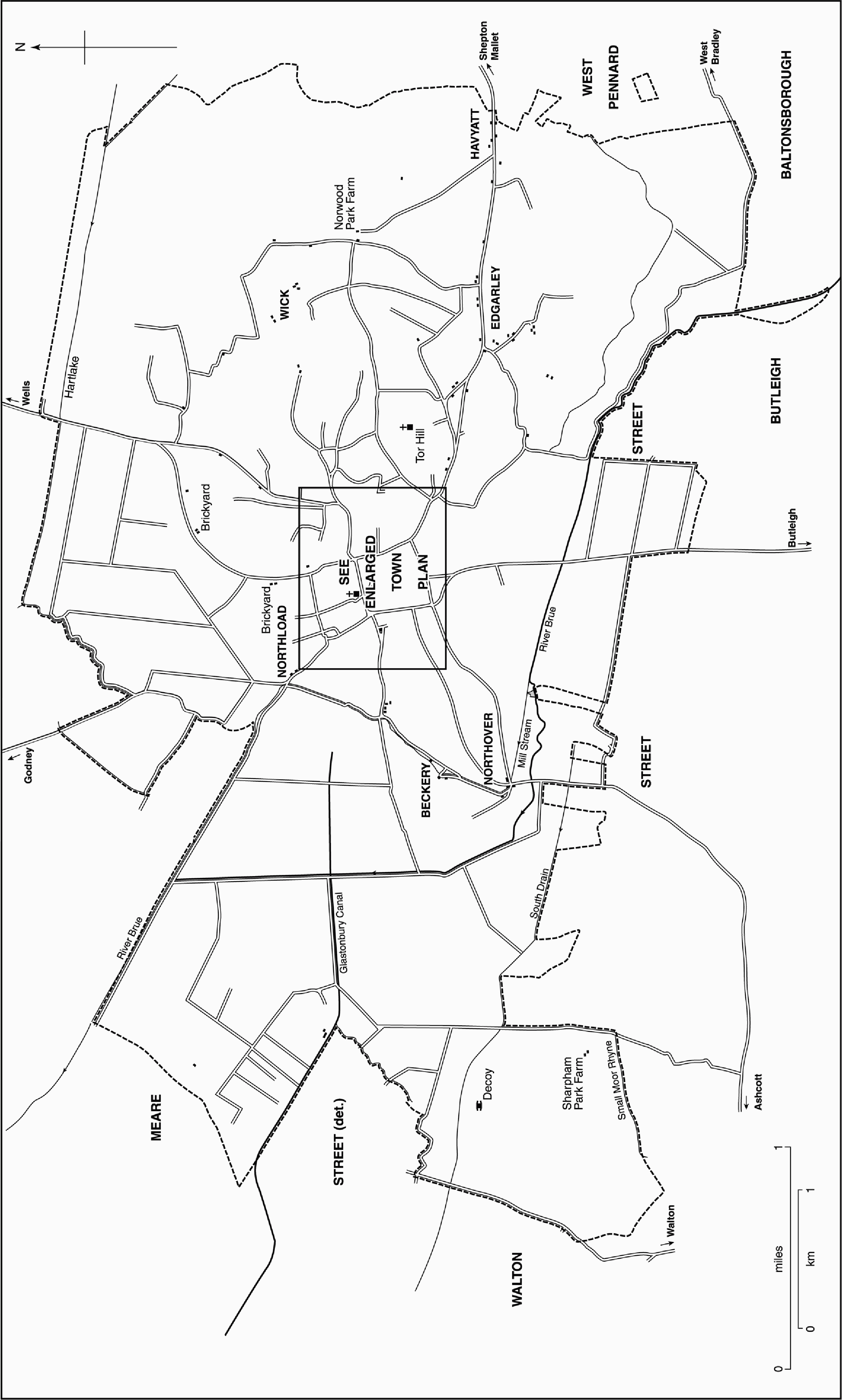
FIG. 6. Glastonbury parish in 1844

FIG. 7. The opening of the Glastonbury canal, 1833
Glastonbury canal, linking the town with the river Brue and Highbridge across Shapwick Heath, was opened in 1833. (fn. 47) It was sold to the Bristol and Exeter Railway in 1848 but continued in use until 1853 and was closed in 1854. It was replaced by the Somerset Central railway whose track ran along the canal bank, continuing the link with Highbridge (fn. 48) but with intended extensions to Burnham for channel crossings to Cardiff, and to Wells and Castle Cary. At the opening of the track to Glastonbury in 1854 the fear of disturbance to the town by excursion trains was voiced. (fn. 49) The extension to Wells, in the original broad gauge, was opened in 1859 when work had also begun on a standard gauge track towards Cole near Bruton. (fn. 50) When Cole was reached in 1862 Glastonbury was linked with the south coast via the Dorset Central railway which, merged with the Somerset Central, became the Somerset and Dorset Joint railway. Through trains between Burnham and Poole ran only for ten years and after 1874 the company's main route ran from Bournemouth to Bath, avoiding Glastonbury. (fn. 51) The town's station, near the basin of the canal, remained, however, a junction for the Wells line. The Wells branch was closed in 1951 and the main line between Highbridge and Evercreech in 1966. (fn. 52) The platform awning was moved to the town centre to serve as covering for market stalls. (fn. 53)
Population
Sixty-two households were recorded in 1086. (fn. 54) The town and parish were not separately distinguished from Glastonbury Twelve Hides hundred in 1327, nor was the town taxed as other towns in the later 14th century. (fn. 55) In 1539 there were 113 men described as able to serve the king, together with 14 bondmen. (fn. 56) In 1548 there were 700 communicants (fn. 57) and in 1563 297 households. (fn. 58) In 1641 458 men signed the Protestation (fn. 59) and at some other date in the 17th century the number of households was 265. (fn. 60) About 1785 there were 360 houses. (fn. 61)
In 1801 the population was 2,035. The total rose gradually until 1841, fell slightly in the next decade, but thereafter rose again slowly, reaching 4,215 in 1891. A slight fall over the next ten years was succeeded by increases, small until 1951 and thereafter growing, the largest between 1981 and 1991 when the total rose from 6,751 usually resident to 7,942. (fn. 62)
Early Settlement
There is no direct evidence of permanent settlement within the parish until the 6th century. Flints from the Upper Palaeolithic, Neolithic polished axes, and the suggestion that the Tor might be a Neolithic maze place Glastonbury within the general context of the surrounding prehistoric sites, and the marsh-edge seasonal settlement known as the Glastonbury Lake Village, found in 1892, parallels the similar settlements at Meare, all dating to the Bronze and Iron Ages. Ponter's Ball has been variously interpreted as an Iron-Age cross-ridge dyke defending a territorium or the boundary of a sanctuary whose centre was the Tor. There may have been Roman buildings on the abbey site and elsewhere in the parish, but the balance of opinion points to the Tor as the site of a monastery of the late 5th or the early 6th century, succeeded by a second foundation nearby and later by the monastery on the present site. (fn. 63) The Mound, to the west of the later town, was formerly identified as a castle but subsequently as a site of sporadic occupation in post-Roman and early medieval times; (fn. 64) and Beckery, a little further west and a settlement centred on a chapel dating from the post-Roman or Anglo-Saxon period, (fn. 65) both demonstrate the use of 'island' sites on the edge of marshland.