A History of the County of Stafford: Volume 8. Originally published by Victoria County History, London, 1963.
This free content was digitised by double rekeying. All rights reserved.
'Hanley: Buildings, manors and estates', in A History of the County of Stafford: Volume 8, ed. J G Jenkins (London, 1963), British History Online https://www.british-history.ac.uk/vch/staffs/vol8/pp142-154 [accessed 30 April 2025].
'Hanley: Buildings, manors and estates', in A History of the County of Stafford: Volume 8. Edited by J G Jenkins (London, 1963), British History Online, accessed April 30, 2025, https://www.british-history.ac.uk/vch/staffs/vol8/pp142-154.
"Hanley: Buildings, manors and estates". A History of the County of Stafford: Volume 8. Ed. J G Jenkins (London, 1963), British History Online. Web. 30 April 2025. https://www.british-history.ac.uk/vch/staffs/vol8/pp142-154.
In this section
HANLEY
The borough of Hanley as it existed in 1910 covered an area of 1,957 acres (fn. 1) and comprised the township of Hanley, the township of Shelton (except for the former glebe land around Stoke station), the Birches Head area, and part of Sneyd Green; these last two districts had been added to the borough in 1905. (fn. 2) Hanley thus occupied the rough triangle formed by the Trent on the east, its tributary the Fowlea Brook on the west, and the irregular Burslem boundary on the north.
The ground rises from under 400 ft. along the two river valleys to over 600 ft. east of Hanley town and at Birches Head; the slope up from the Trent in this north-eastern part of the area is particularly steep. Shelton was the larger of the two townships, 995 acres to Hanley's 483, (fn. 3) and the boundary between the two ran along the present Bryan Street, then east of Stafford Street, across Lichfield Street, and down through Joiner's Square to the Trent. (fn. 4) Hanley township thus included the eastern half only of the town, with the Hope Street area, Piccadilly, Pall Mall, and Albion Street all lying in Shelton. The HanleyShelton area is crossed by three old roads, those between Newcastle and Cheadle, between Newcastle and Leek, and between Great Chell and Hanley. The mid-19th-century road from Stoke to Endon runs through the eastern part of the former borough along the low ground beside the Trent.
Except for the extreme north-eastern part, where the belt of farming land around Abbey Hulton begins, there is nothing in the area to recall the moorland settlement which still survived in the early 18th century. Over the last 200 years the district has become solidly built up and industrialized, with the town of Hanley now the shopping and cultural centre of the Potteries.
Hanley existed as a vill in the early 13th century. (fn. 5) In the early 18th century it was still 'a humble collection of dwellings' which lay chiefly around Upper Green (at the junction of Keelings Lane and the present Town Road), and Lower Green (the later Market Square). The whole formed 'two small villages, half a mile apart'. (fn. 6) Hanley Green as an alternative name to Hanley was in use by the end of the 16th century, and its use still lingered in the middle of the 19th century. (fn. 7) By 1775 the built-up area had spread westwards into Shelton township and there was continuous building along what are now Town Road, Old Hall Street, Albion Street, and Marsh Street. (fn. 8) The growth of the town is reflected in the building of the church in 1738, its extension in 1764, and its rebuilding in 178790. (fn. 9) By the 1790's Hanley, though still smaller than Burslem, was 'an improving and spirited place'; it was, however, 'built so irregularly that, to a person in the midst of it, it has scarcely the appearance of anything beyond a moderate village; yet if the houses had been properly joined together, it would not only make a capital town but a well-built one'. (fn. 10)
In the first third of the 19th century the ground plan of the present town-centre, including the area round Piccadilly and Pall Mall, was completed. The streets in the rectangle formed by Albion Street, Lichfield Street, Mollart Street (then Union Street), and Bethesda Street on the south side of the town, much of the area around Hope, Hanover, and Union Streets on the north side, and many of the streets on the eastern slope above the town had been laid out. Charles Street and Well Street represented the beginning of development in the Wellington area to the south-east. (fn. 11) In the 1830's Hanley was considered 'a large modern town', the largest in the Potteries and the second in Staffordshire; its streets 'generally spacious and well paved', its houses of 'neat appearance, and some of them, as well as the public edifices . . . spacious and elegant'. (fn. 12) On the other hand much of the town was overcrowded and insanitary. (fn. 13) In 1850 it was noted that 'the principal streets have some good shops; and there has been lately finished a range of shops far above the standard of everything else in the Pottery district'. (fn. 14) There was a great rise in population in the early 1850's owing to the increased numbers employed at Lord Granville's pits. (fn. 15) By 1857 several groups of new streets had been laid out in the Wellington area, which was constituted a new ecclesiastical parish in 1845, and streets had also been laid out west of Bethesda Street and in the Bryans Wood area on the north side of the town. (fn. 16) In the course of the next 20 years new streets were built leading off both sides of Lichfield Street and the west side of York Street. (fn. 17) In this way Hanley town was solidly built up before 1880. Soon after this date, however, slum clearance was carried out in Old Hall Street and improvements were made to buildings in the Crown Bank area. (fn. 18) Extensive demolition of slum property was begun shortly before 1939 and has continued since the war, particularly in the Wellington area, the streets between Bucknall Old and New Roads, Bryan Street, and the area round Bethesda and Warner Streets. (fn. 19) Many of the cleared areas remain undeveloped spaces, but there has been some rebuilding from the late 19th century up to the present time. (fn. 20)
The district known as Joiner's Square existed by 1829 as a few houses and collieries south of the Caldon Canal on the east side of the track later to be Lichfield Street. It was then already suffering from mining subsidence. (fn. 21) Leek Road, opened in the early 1840's, (fn. 22) still marked the limit of the area in 1857, (fn. 23) but in the course of the next 20 years or so there was further development including the terraced houses in Austin Street and Simpson Street on the south side of Leek Road. (fn. 24) New streets of houses between the road and the Trent continued to be built until recent years, including council estates dating from the years between the two world wars (fn. 25) and the period since 1945. The pottery works of Johnson Bros. was extended on both sides of the canal in Eastwood Road between 1888 and 1896. (fn. 26)
There was extensive building along Keelings Lane by 1775 as well as at Upper Green around the junction of the lane with what is now Town Road. (fn. 27) By 1829 William Ridgway of Northwood House (earlier known as Prospect House) had changed the area 'from a rude and demoralized part of Hanley into a beautiful, cleanly, well-ordered hamlet' which was known as Northwood by 1832. Not only had he 'converted his residence from a plain, unpretending house into an elegant suburban villa' but he had also 'cleared the neighbourhood of a number of unsightly cottages and objects which formerly surrounded it . . . erected or improved some good neighbouring houses', and built a school and 'several neat almshouses for decayed widows'. (fn. 28) The church of Holy Trinity in Lower Mayer Street was built in 18489, (fn. 29) and the population of the new parish, 3,300 in 1850 and 'for the most part very poor', continued to increase. (fn. 30) Several new streets were built on the east side of Keelings Lane about this time. Others were laid out on the south side of Providence Square, the former Upper Green. (fn. 31) A new terrace was built in Lower Mayer Street in 1870. (fn. 32) In the last quarter of the 19th century new streets were built southward from Providence Square, joining those to the northeast of Hanley town. To the east of Providence Square the series of streets known as Birches Head was laid out around Grove House. (fn. 33) In the first decade of the 20th century the streets around Northwood Park were laid out; the park itself, some 11 acres in extent, was opened in 1907 as part of the jubilee celebrations of Hanley's incorporation. (fn. 34) There is housing of the years between the two world wars around the junction of Keelings Lane and Bucknall Old Road, in Cromer Road to the north, in Birches Head Road, and to the west of Chell Street. (fn. 35) Housing of the late 1950's has replaced the old terraces in the streets immediately south of Providence Square, and new streets were still being laid out on the north side of Birches Head Road in 1959.
The development of Shelton township is partly, as already shown, the result of the south-westerly extension of Hanley town over the boundary of Hanley and Shelton townships. The original centre of Shelton was probably the area round Shelton Old Hall on the ridge to the east of the Stoke-Hanley road. (fn. 36) Before the end of the 16th century Snape Marshthe present Marsh Street district of Hanley townwas an inhabited area. (fn. 37) By 1775 the main part of Shelton lay along the stretch of the road between Stoke and Hanley now known as Snow Hill and Broad Street, and in the Marsh Street area. (fn. 38) There was further development southwards later in the century. The Caldon Canal was constructed under an Act of 1776, and on its south bank were built the Chatterleys' Shelton Hall and the Ridgways' Cauldon Place house and pottery works. (fn. 39) By 1832 further development in Shelton included the group of streets running southwards off Broad Street to what is now Cannon Street, St. Mark's Church, built in 18314, a few streets north and west of the church, and Charles Meigh's Grove House farther west still. There had also been some development in the Etruria Vale area near Etruria Basin, and the present road from Shelton to Newcastle existed as far as the east bank of the Trent and Mersey Canal; there was already a terrace of cottages, several of them still (1960) inhabited, at the eastern end of the road. (fn. 40) The terraces on the north side of Bedford Street date from the early 1850's. (fn. 41) By 1857 the streets north of St. Mark's had been extended, including Sun Street linking Broad Street and the wharves at Etruria. (fn. 42) In the course of the next 20 years the streets on either side of Stoke Road north of the Caldon Canal were laid out, and terraces were built in Lower Russell Street, (fn. 43) now part of Shelton New Road. From c. 1876 the streets south of the Caldon Canal were being laid out, and by 1897 1,036 houses had been built in the area. (fn. 44) During this same period new streets were built in the Mousecroft area to the east of St. Mark's, and the housing between Rectory Road and Havelock Road and around the Etruria Vale end of Sun Street is also mainly of this period. (fn. 45) Hanley Park was laid out in 18927 on some 63 acres of Stoke Fields, waste ground lying on either side of Victoria Road and crossed by the canal. (fn. 46) Some large houses were built on the north side of the park about the turn of the century, (fn. 47) and a new church of St. Jude was built in Victoria Road in 18991901 in place of the nearby mission chapel of 1880. (fn. 48) Clough Street which now runs from Marsh Street through the Tinkersclough area to Etruria Vale Road still ran only as far as the railway goods yard in the early 1920's. (fn. 49) By 1939 there had been slum clearance at the west end of Sun Street (fn. 50) and by 1950 extensive clearance in the area north of St. Mark's. (fn. 51) There are housing estates of the period between the world wars to the east and south of Hanley Park, to the south of the cemetery, and round the junction of Etruria Vale Road and Sun Street.
There were three or four small houses around the Ridge House in the western part of Shelton township c. 1680, (fn. 52) but the village of Etruria nearby was the creation of Josiah Wedgwood after his purchase of the Ridge House estate in 1767 (fn. 53) 'a colony newly raised where clay-built man subsists on clay'. (fn. 54) On the west bank of the Trent and Mersey Canal, then still under construction, and just off the Newcastle-Leek road, Josiah opened his pottery works in 1769; on the rising ground to the east of the canal he built Etruria Hall; and on either side of the main road between the Fowlea Brook and the canal he erected cottages for his workmen. (fn. 55) Seventy years later Etruria was in the main still a village of one street containing 'about 120 workmen's dwellings . . . with an inn and some houses of a better class for farmers, clerks and others'. (fn. 56) The first nonconformist chapel had been built in 1808, and the church of St. Matthew was opened in 1849. (fn. 57) In 1841 Lord Granville completed the first part of his ironworks in Mill Street (now Etruria Road); (fn. 58) the railway was opened in 1848. (fn. 59) Although Salem Street was in existence by 1845, it was apparently not then built up, (fn. 60) but there were terraces on both sides by 1857; (fn. 61) by that time also the terraces at the northern end of Fold Street (now Etruscan Street) had been built. (fn. 62) By 1865 there were some 200 houses in the village, most of them still occupied by employees of the Wedgwoods. (fn. 63) Before 1880 a new terrace in Fold Street and the terraces at the Salem Street end of Cavour Street had been built, and there were terraces along Mill Street near Lord Granville's ironworks. (fn. 64) In the last quarter of the century streets of terraced housing were laid out between the west end of Mill Street and Etruria Vale Road and in the village itself Humbert Street was built. (fn. 65) Belmont Road and Dundee Road between the canal and Etruria Vale Road were in existence by 1888, (fn. 66) Ladysmith Road and Kimberley Road in the same area date from the turn of the century, (fn. 67) and Pretoria Road was added during the period between the world wars; during the same period the terraces in Dundee Road and Ladysmith Road were extended and the houses in Belmont Road built. The 11-acre Etruria Park at the junction of Etruria Road and Etruria Vale Road was opened in 1904. (fn. 68) Etruscan Street was extended past the new gasworks to Shelton New Road at Cliff Vale c. 1908. (fn. 69) The housing at the west end of Cavour Street dates from the 1930's after the street had been extended through the grounds of Etruscan Villa. (fn. 70) As a result of the growth of its industries, (fn. 71) Etruria lost its rural character. Etruria Grove, lining the main road eastwards from the canal bridge and said to have been planted by Josiah Wedgwood, disappeared in the 1870's, (fn. 72) and the landscape has long since been dominated by the iron and steel works and the gasworks. Brindley Bank, the open ground between the Hall and the main road, was levelled in 1951 by the Shelton Iron and Steel Company and now forms their sports ground. (fn. 73) From c. 1860 mining subsidence has been very extensive; the canal represents the original level of the area and its western side has had to be built up some 12 ft., while elsewhere the ground has dropped as much as 30 ft. (fn. 74) There has been extensive clearance of the cottages in the main street since 1956. (fn. 75)
By 1775 there was some building along the stretch of the main road where it climbs from Etruria up to Cobridge. (fn. 76) This included Cobridge House, the home of the Hales family from the late 17th century to the 19th century, which was replaced by the present St. Augustine's Home early in the 20th century. (fn. 77) In 1832 the road was still tree-lined along its western side where it skirted the race-course east of Etruria Hall, (fn. 78) but with the opening of the pit on the course and of the ironworks on the opposite side of the road the trees disappeared (see above). The terraced cottages on the east side of the road below Cobridge had been built before 1880, and those on the north side of Century Road, the former Boothen Lane, date from the later 19th century. (fn. 79) Two more terraces had been built on either side of Cobridge Road by 1922. (fn. 80) There is extensive council housing of the years between the world wars and the period since 1945 partly in place of and partly behind the terraces on the east side of the road; some rebuilding was still in progress in 1959.
In 1666 there were 14 persons chargeable for hearth tax in Hanley township and 36 in Shelton, (fn. 81) while in 1701 the population of the two was respectively 326 and 499. (fn. 82) In 1811 Hanley township had a population of 4,481 and Shelton one of 5,487. (fn. 83) By 1861 the population of the new borough was 31,95314,678 in the Hanley portion and 17,275 in the diminished Shelton portion. (fn. 84) In 1901 the population of the borough was 61,599, (fn. 85) and in 1911 the area of the former borough as extended in 1905 had a population of 66,255 (fn. 86) and in 1921 one of 67,891. (fn. 87)
The road from Newcastle to Cheadle branched from the Newcastle-Uttoxeter road at Cliff Bank in Stoke and ran along the present Shelton Old Road and up the slope of Stoke Road, Snow Hill, and Broad Street to Hanley. This slope was 'formerly a deep cutting and a high footpath unpaved', frequently blocked by snow in winter and described in 1763 as 'in a ruinous condition, narrow and incommodious'. From Broad Street the road then followed the present Albion Street, Old Hall Street, and Bucknall Old Road, descending to the Trent and Bucknall by a hill 'so steep that the road on one side was paved with stone blocks'. (fn. 88) The portion from Cliff Bank to Snape Marsh at the north end of the present Broad Street was turnpiked in 1763 as an extension of the Newcastle to Uttoxeter turnpike; (fn. 89) the remainder was turnpiked in 1771. (fn. 90) A new road (the present Liverpool Road) was built from a point near Shelton Wharf into Stoke in 17912, continuing thence along the present London Road to the main Stone-Newcastle road. (fn. 91) By 1832 Bucknall New Road had been built from the end of Old Hall Street, (fn. 92) thus avoiding the steep hill on Bucknall Old Road. The road from Shelton to Newcastle, which runs from Bedford Road near its junction with Stoke Road, was extended westwards from the Trent and Mersey Canal at Cliff Vale in the late 1830's as part of the Newcastle to Uttoxeter turnpike system. (fn. 93) By 1806 a toll-gate had been erected about mile to the north of Shelton Wharf opposite the present Cauldon Road, (fn. 94) and the toll-house, a plain double-fronted brick cottage, is now (1960) occupied as a shop. By 1831 there was also a toll-gate at the eastern junction of Bucknall Old and New Roads (the Ivy House Gate), (fn. 95) and this still stood in the 1870's. (fn. 96)
The Newcastle-Leek road, which crosses the Fowlea valley at Etruria and runs up to Cobridge along Cobridge Road, was turnpiked in 1765 when it was also joined to the road from Newcastle to Cheadle at Snape Marsh by the turnpiking of Boothen Lane (now Century Road) and Marsh Street. Hanley was thus linked with the Lawton, Burslem, and Newcastle system via Cobridge. (fn. 97) A more direct route to Burslem was provided by Waterloo Road, built from Vale Place as far as Cobridge by 1814 and extended to Burslem in 181517. (fn. 98) Mill Street (now Etruria Road) had been built from the eastern end of Etruria to the western outskirts of Hanley by 1832; (fn. 99) plans for its continuation into the centre of Hanley in 1835 (fn. 100) and 1839 (fn. 101) were not carried out, but it was being extended as Trinity Street to meet Stafford Street at Miles Bank in 1847. (fn. 102) Etruria Vale Road running from the east end of Etruria up to Bedford Road and so into Stoke Road was in existence by 1775. (fn. 103) There was formerly a toll-chain across the Newcastle-Leek road where it entered Etruria Village, and c. 1880 toll was taken there for charity on festive occasions. (fn. 104) By 1799 there was a toll-gate at the junction of the main road with Century Road, and this was still in use in the 1870's. (fn. 105) Another stood at the junction with Etruria Vale Road by 1832 (fn. 106) and was still in use c. 1876, while the house was not taken down until 1904 when Etruria Park was laid out and the road widened. (fn. 107) By 1832 there were also toll-gates in Etruria Vale Road on the slope between Rectory Road and Sun Street and in Vale Place at the end of Waterloo Road; both were still in use in the 1870's. (fn. 108)
The road running from Great Chell and Sneyd Green through the centre of Hanley to the Albion Inn on the Cheadle road was turnpiked in 1770. (fn. 109) There was a toll-gate at its junction with Keelings Lane at Upper Green by 1820, and there seems at some time to have been another a little to the southwest, presumably at the junction of what are now Hulton Street and Town Road. (fn. 110)
The road from Stoke to Endon was built between 1840 and 1842 (fn. 111) and runs as Leek Road through the eastern part of the area. Lichfield Street was extended to Fenton at the same time (the present Victoria Road), crossing Leek Road at a point south-west of Joiner's Square. A toll-gate, still in use in 1857, was set up at the crossing. (fn. 112)
Bucknall Bridge carrying the road from Newcastle to Cheadle over the Trent was a county responsibility by 1830. (fn. 113) The bridges carrying this road, its Liverpool Road branch, and the road from Newcastle to Leek over the Fowlea Brook are described elsewhere. (fn. 114)
By 1802 there was a daily coach service to London and Liverpool from the Swan Inn in Market Square. (fn. 115) This inn was a building probably dating from the late 17th or early 18th century. (fn. 116) It was demolished in the 1840's to make way for the new market hall. (fn. 117) By 1818 the area enjoyed the same coaching facilities as Burslem and Stoke, two coaches daily between London and Liverpool and a third three times a week between Birmingham and Liverpool, all from the 'King's Head' at the west end of Piccadilly. (fn. 118) By 1824 there was also a 'safety' coach from the 'King's Head' to Leek via Burslem once a week and another three times a week through Stoke and Longton to Stafford and Birmingham. (fn. 119) By 1850 the posting-houses were the Albion Hotel in Old Hall Street and the 'Saracen's Head' in Stafford Row (now Stafford Street), (fn. 120) and by 1860 the 'Saracen's Head' and the 'King's Head'. (fn. 121) By 1851 there were omnibuses from the posting-inns to Stoke station seven times a day, and Hanley was also on the route of the Longton to Burslem omnibus, which called twice a day at the inns. (fn. 122) A horse-drawn tram service was started between Hanley and Burslem in 1862, a 'street railway' built by George Train of Boston, Mass. (fn. 123) It was replaced by steam-driven trams in 1882 when the line from Longton to Stoke was extended to Hanley and Burslem. (fn. 124) Electricity was substituted for steam after the trams had been taken over by the Potteries Electric Traction Company in 1898 and new lines were then opened: to Etruria and Newcastle in 1900, to Fenton and Longton via Victoria Road in 1900, and to Sneyd Green via Town Road and Chell Street in 1905. (fn. 125) Motor buses, introduced from 1913, gradually replaced the trams between 1926 and 1928. (fn. 126) A new garage was opened in Clough Street in 1953. (fn. 127)
From 1835 there was a horse-post to Hanley and Shelton from Newcastle, the postal centre for the Potteries. Stoke became the postal centre in 1854 with the opening of the station post office there. (fn. 128) By 1790 Hanley had its own postmaster and Shelton a postmistress. (fn. 129) There was a post-office at Etruria by 1834 (fn. 130) and one at Northwood by 1860. (fn. 131) The general post office in Tontine Street was opened in 1906. (fn. 132)
The Trent and Mersey Canal built in 176677 (fn. 133) passes to the west of Shelton and through Etruria. There was a wharf at Etruria by 1783, probably at Etruria Basin in Etruria Vale, where a wharf was certainly in existence by 1802. (fn. 134) There was a wharf at Shelton by 1791, probably on the south side of Stoke Road; there was another on the north side of the road by 1802. (fn. 135) By 1816 the canal company had a tramway for goods from the wharf at Etruria Basin to Miles Bank in the centre of Hanley; (fn. 136) by the 1870's it ran only as far as the goods station in Etruria Road. (fn. 137) By 1851 the public wharves in use were those at Shelton south of the main road, at Etruria Vale, and in Etruria itself. (fn. 138) Shelton Wharf was evidently closed c. 1870, (fn. 139) that in Etruria Vale continued in use until at least the 1870's, (fn. 140) and Etruria Wharf, off Belmont Road, is still used. (fn. 141) The Caldon Branch Canal was built from the main canal near Etruria Basin to Froghall under an Act of 1776. (fn. 142) There were two wharves on this branch near Joiner's Square by 1832, one of which, to the east of the Lichfield Road bridge, was still in use in the 1870's. (fn. 143) The Caldon Wharf of 1851 may have been one of these or else a wharf attached to the Cauldon Place Pottery where there was certainly a wharf in the 1870's. There was then also a wharf to the east, on the opposite side of Chatterley Bridge, belonging to the canal company, and by 1907 this was the property of the borough council and known as Town Wharf; the site was occupied in 1959 by Podmores (Engineers) Ltd. (fn. 144) There was a third wharf in this part of Shelton in the 1870's, near the Russell Street bridge. (fn. 145) Pottery materials continue to be conveyed from the Cockshott railway sidings on the main canal south-east of Hanley cemetery to Joiner's Square. (fn. 146)
The main railway line from Stoke to the north runs along the Fowlea valley and has a station at Etruria. When the line was opened in 1848 Etruria Station lay on the north side of the main road just over the Wolstanton boundary where the Loop Line now branches off. (fn. 147) It was rebuilt on its present site south of the main roadon the Stoke side of the former Hanley-Stoke boundarywhen the first part of the Loop Line was opened in 1862. (fn. 148) The Loop Line began as a branch to Hanley where a station was built on the south side of Etruria Road, (fn. 149) opposite the site now occupied by the Grand Hotel. With the extension of the line as far as Burslem in 1873 the station was moved to its present site on the north side of the road; it was rebuilt c. 1916. (fn. 150) Lord Granville's mineral lines to his ironworks in Etruria and the line to his Shelton Colliery north of Hanley town were built under an Act of 1847 about the same time as the main line, from which they branched at Etruria. (fn. 151) The line from Stoke to Biddulph and to Leek which runs under Bucknall Road to the west of Bucknall was opened for mineral traffic in 1860; Bucknall and Northwood station off Bucknall Road was opened for passenger services in 1864. (fn. 152)
Buildings
The centre of Hanley preserves the irregular layout of the late-18th-century village (fn. 153) and was described in 1960 as 'an archipelago of island sites'. (fn. 154) The buildings occupying these variously shaped islands have been replaced piecemeal from the early 19th century onwards and are now of widely different heights, styles, and materials. Because of Hanley's development as an important shopping centre and the large scale of its later commercial buildings this lack of uniformity is even more pronounced than in the other Pottery towns. A few low-built brick houses dating from the first third of the 19th century have survived, notably in New Hall Street, Parliament Row, and Tontine Street. On the south side of Fountain Square the French Horn public house and the single-story shops adjoining it are of this type. Town Road (formerly High Street) contains some more substantial buildings of the same period, including the former Congregational chapel (1784), (fn. 155) now altered for use as a roller-skating rink, and its adjoining manse. In New Hall Street the Georgian front of Hope Congregational Church (1812) (fn. 156) is little changed. Immediately south of the town-centre parts of Pall Mall, Albion Street, and Bagnall Street are free of shop fronts and retain something of the scale of the early town. The most notable older building in this area is Bethesda Chapel, built in 1819 and altered in 1859 and 1887, together with its Sunday schools (1819) and graveyard. (fn. 157) The winding road leading south-westwards to Stoke, now known as Snow Hill, Howard Place, and Stoke Road, is still partly residential in character. To the south of St. Mark's Church there are some middle-class terraced houses as well as several larger houses in their own gardens, some of them dating from the early 19th century. Near the Stoke boundary three tall ranges of late19th-century pottery buildings (now occupied by Messrs. Grimwade and the Empire Porcelain Company) form an impressive group.
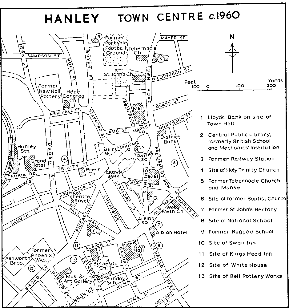
HANLEY TOWN CENTER c.1960
The former town hall at the upper end of Fountain Square, built in 1845, had a severely Classical twostoried stone front of seven bays with a central Ionic portico surmounted by a pediment. (fn. 158) Lloyds Bank, which had occupied the premises since 1886, rebuilt them in 1936. (fn. 159) The present town hall in Albion Square, built as the Queen's Hotel in 1869 and acquired for the town in 1884, (fn. 160) is a large three-storied brick building with stone dressings, its front having projecting wings in the centre and at both ends. Designed by Robert Scrivener, it is domestic rather than monumental in character with echoes of the French Renaissance in its high-pitched roof and dormer windows.
The covered market occupying a large island site between Tontine Street and Parliament Row was built as a shambles in 1831 (fn. 161) and is a Classical stone structure, mostly of one story. The principal front, facing Tontine Street, has a central feature consisting of an arched entrance surmounted by a stone turret and cupola; this is connected by three-bay Doric colonnades to pedimented side wings. On the north side of Market Square the market opened in 1849 on the site of the Swan Inn (fn. 162) has an impressive stone facade of three stories with balustrades and a row of stone vases set above tall shop windows. These appear to have been the first of Hanley's more ambitious shop fronts; (fn. 163) the same elevational treatment, on a slightly smaller scale, has been taken round the eastern side of the block where it faces Town Road.
The District Bank to the west of Market Square was originally an early-19th-century building of pale brick, designed by T. W. Atkinson in 'the gabled or Tudor style of architecture'. It was noted c. 1840 that 'its elevation rises above all the neighbouring houses and makes it conspicuous at a considerable distance. (fn. 164) The bank was rebuilt in 1881 (fn. 165) in a late19th-century version of the same style.
The former British School and Art School in Pall Mall (1818), (fn. 166) now part of the city library, has an impressive brick front with neo-Classical stone dressings, retaining its twin doorways flanked by Doric pilasters and its contemporary cast-iron railings and gate-piers. Originally the building consisted of two tall stories, but a third was added in 1880. (fn. 167) The two painted barbotine portraits over the entrance to the eastern extension were executed by George Cartlidge, a ceramic craftsman and a teacher of painting at the Art School from 1897. (fn. 168) The adjoining part of the library to the west was built as the Mechanics' Institution in 185961. Its stone front was designed by Robert Scrivener in the Classical style with a Tuscan order below and an Ionic order above. (fn. 169) The upper story eventually became unsafe and was taken down after the opening of the new museum in Broad Street in 1956. (fn. 170)
Of the dozen private dwelling houses 'of the first class' mentioned by Ward c. 1840 (fn. 171) only a few remain and all of these have been put to other uses. The favoured residential districts at this period included Northwood, the area immediately east of the town-centre now represented by Old Hall Street and Albion Square, and the southern area around the road leading to Stoke. At Northwood the only traces of the improvements carried out by William Ridgway in the early 19th century are a few brick and stucco villas near Keelings Lane. Among them a two-storied stucco house with 'Gothic' features in Birch Street was once a school known as 'Alfieri's Academy'. (fn. 172) In Old Hall Street the former St. John's Rectory, dating from the 1840's, has recently been demolished. (fn. 173) On an adjoining site is the large house which was owned by the Chatterley family in 1849 and occupied by Joseph Clementson. (fn. 174) Bank House, on the site of which the Queen's Hotel (now the town hall) was erected in 1869, was an impressive brick building standing in a walled garden and probably dating from the late 18th century. It had a pedimented doorway and consisted of a three-storied block with an adjoining two-storied wing; the forecourt was bounded by a low brick wall and iron railings. (fn. 175) Albion House, (fn. 176) a two-storied stucco building which stood opposite, was probably built in the 1830's. A plain two-storied brick house of the late 18th century which still stands in Cannon Street is now used as a local headquarters by the Royal and Antediluvian Order of Buffaloes; it has a modillion cornice and a central doorway surmounted by a Doric frieze and a segmental pediment. The dwelling house built by John Baddeley (d. 1772) which formerly stood in front of his pottery works (fn. 177) in Shelton High Street (now Broad Street) was described by Ward as 'a specimen of a first-rate house of the last century'. It was occupied in Ward's time by a Mr. Hicks (probably Richard Hicks, d. 1844), by Lydia Hicks between at least 1849 and 1854, and by Crapper and Company, dentists, by 1860. Known as the White House by 1876, it was offered for sale after Crapper's death in 1891. (fn. 178) In the 1840's William Yates was occupying an 18th-century house opposite the west end of St. Mark's Church where his family had been 'long seated' (fn. 179) but which has now disappeared. Grove House, altered and enlarged by Charles Meigh c. 1840 and at that time containing a fine collection of pictures, stood near the junction of Snow Hill and Bedford Road. (fn. 180) Cauldon Place, John Ridgway's 'elegant modern mansion' attached to his pottery works, appears to have been altered beyond recognition. (fn. 181) Shelton Hall opposite, dating from 1782, was demolished in 1959. (fn. 182) Shelton Old Hall, one of the few ancient buildings in the area, stood on the crown of the hill to the north-east until its destruction by fire in 1853. (fn. 183)
Etruria Hall, completed in 1770, was built by Josiah Wedgwood for his own occupation as part of his development of the former Ridge House estate on the western outskirts of Shelton. (fn. 184) His architect was Joseph Pickford of Derby. (fn. 185) The site chosen was on rising ground on the north side of the road to Newcastle, the house facing towards the Etruria Works which stood beyond the Trent and Mersey Canal about 300 yards away. (fn. 186) The intervening area was laid out and planted as ornamental grounds leading down to two small lakes near the canal. There appears to be no evidence for the suggestion that 'Capability' Brown was employed as a landscape gardener at Etruria; (fn. 187) it is more probable that, as in the design of the house and works, Wedgwood put many of his own ideas into practice. Owing to the gradual enlargement since 1858 of the Shelton ironworks, all traces of the gardens and parkland surrounding the hall have been obliterated, the last of Josiah Wedgwood's trees having been felled in the 1870's. (fn. 188) Etruria Hall was originally a square threestoried brick house with stone dressings, typical of its period, the three central bays of its five-bay front projecting slightly and being surmounted by a pediment. (fn. 189) Late in Wedgwood's life two flanking wings were added, both square blocks of two stories with single-story links connecting them to the original building. In 1844 the house was said to contain 34 rooms. (fn. 190) Below the building were vaulted cellars in which Wedgwood's private laboratory was situated. (fn. 191) The south wing was extended and the interior of the house largely remodelled c. 1916; (fn. 192) further alterations were made at subsequent dates. The only original fittings which remain appear to be a basket grate in a first-floor room and a balustrade in the 'Chinese Chippendale' style to a secondary staircase. In 1781 and 1784 Flaxman had supplied designs for decorative plasterwork and a painted ceiling but it is doubtful whether these were ever executed. (fn. 193) Bank House, built for Wedgwood's partner Thomas Bentley but never occupied by him, served as a home for the Wedgwoods from November 1769 until the hall was completed in the following year. (fn. 194) It was a tall, square, three-storied house standing near the main road to the south of Etruria Hall. (fn. 195) The house was demolished in 1819 but an L-shaped range of outbuildings, at one time occupied as Grove Farm, still survived in the early 1950's. (fn. 196)
The former North Staffordshire Infirmary at Wood Hills, Etruria, was built in 181619 to the designs of Joseph Potter of Lichfield. It was enlarged at various periods and demolished after the infirmary was moved to Hartshill in 1869. (fn. 197) The buildings, which were faced with 'Roman' cement, consisted of several two- and three-storied ranges built on a slope and roughly enclosing a courtyard. The principal part had a central five-bay colonnaded portico, approached by a double flight of steps and recessed between two projecting gabled wings. (fn. 198)
The earliest houses in the Potteries known to have been put up expressly for workers in the industry were those at Etruria, built by Josiah Wedgwood in the late 1760's. (fn. 199) Apart from a row of six cottages forming an extension of the canal frontage of the works themselves, these were all built in terraced blocks on both sides of the road to Newcastle (now Etruria Road) and stretched westwards from the canal bridge. (fn. 200) They were mostly simple four-roomed cottages with small-paned casement windows and plain doorway openings, the floors to the lower rooms being of brick and the front doors opening straight into the living rooms. Apart from this last feature they were still considered to be well built and generously planned nearly a hundred years later. (fn. 201) Wells and pumps were provided for every few dwellings and there were several communal bakehouses where villagers could bake their bread for d. a loaf. (fn. 202) All the earliest cottages, with the exception of an altered example incorporated in the Etruria Works, had been demolished by 1960, most of them in the previous decade. (fn. 203)
The oldest terraced houses to survive in the centre of Hanley appear to be those in John Street, dated 1807. Some of these are superior houses with pedimented doorcases and long back yards, but all are built on the 'cottage' plan, back kitchens, where they exist, being later additions. (fn. 204) Several streets of terraced cottages to the north-west of St. Mark's Church probably date from the first quarter of the 19th century, among the oldest being Yates Street (formerly William Street) where there is a date tablet of 1818. In the present St. Mark's Street a few cottages with small front gardens survive; most of this row and other early terraces disappeared when a large garage was built and the surrounding area levelled between 1955 and 1957. (fn. 205) In Windmill Street to the north-east of the central area a row of cottages with simple wood doorcases carries the date 1831 above an arched entry. Higher up the street on the opposite side another entry is dated 1834. In this case the houses have round-headed doorways with moulded archivolts and projecting keystonesan early use of this feature which was a favourite one in the Potteries for about 20 years. (fn. 206)
By 1850 there were several working-class areas in Hanley where the houses appear to have been built systematically round a series of communal courts. These were particularly noticed in Davis Street (between the Trent and Mersey and the Caldon Canals) while conditions were said to be very bad in William Street (now Yates Street) and the other streets to the north of St. Mark's Church. (fn. 207) As a contrast attention was drawn to a row of cottages belonging to John Ridgway, each let at 10 a year; 'the back yards are paved with brick, each house has a washhouse and a separate privy and a small garden; all is clean and comfortable'. (fn. 208)
By the end of the century Hanley's exceptionally rapid increase in population was causing serious overcrowding. Old property in the centre of the town, shut in by later buildings, had deteriorated and was attracting the poorest class of tenant by its lower rents. In 1901 the worst areas were said to be in the Hope and Etruria wards and in 'a quarter of the town not many minutes walk from Shelton Church'. (fn. 209) A typical 'dark spot' was a court off Marsh Street which contained twelve dwellings, each having one room downstairs with a small back-place (the latter without fireplace or sink) and two corresponding rooms above. They were arranged in two rows, one without back access, and opened upon a common yard where they shared one water tap, one dustbin, and five water-closets. (fn. 210)
In some parts of the town, however, conditions were better: in 1899 it was stated that good workingclass houses in Hanley, containing two bedrooms, two dwelling rooms, a back kitchen, and a fair-sized yard, were let for between 5s. and 5s. 4d. a week including rates; sixteen new streets had been built in the past year. (fn. 211) By 1902 there were some superior houses with bathrooms which commanded a higher rent than the normal 5s. 3d. (fn. 212) In the same year a scheme was submitted to the corporation for 270 cottages to be built on the Park Estate, each with a living room, a scullery, a bathroom, and three bedrooms. (fn. 213) There were also schemes for model lodginghouses and for two-storied blocks of flats. (fn. 214)
Manor
William of Hanley held 3 virgates in the vill of Hanley in 1212 as a royal sokeman, paying the king 6s. rent. (fn. 215) Although in 1227 the Crown confirmed to Henry de Audley a grant of 'all the land of Hanlih' made by Richard son of Noel of Hanley, (fn. 216) William of Hanley was holding the vill of the king in 1236 for a rent of 6s. payable at Newcastle and for 40 days' castleguard there. (fn. 217) The overlordship thereafter descended with Newcastle until at least 1650. (fn. 218)
In 1297 Robert Auxtin, lord of Hanley, held Hanley by a rent of 6s., the provision of a foot-soldier at the castle for 40 days in war-time, and the usual services including suit at the three-weekly court of Newcastle; Robert also paid a fine of mark to enclose 31 acres of waste and with the other tenants of Hanley rendered 6d. an acre for the 70 acres of land which they held there. (fn. 219) In 1320 Robert Auxtin of Hanley granted his house and lands there to John de Kynnersley, clerk, a conveyance confirmed by Robert's son John, and in 1321 Stephen Auxtin of Hanley granted John de Kynnersley all his capital messuage and lands there. (fn. 220) What was called the manor of Hanley was conveyed in 1324 by Ralph, the son of William son of Thomas Swanild, to John de Kynnersley who the following year granted it to his great-nephew Nicholas de Kynnersley. (fn. 221) Before 1371 Nicholas, who died childless, had conveyed the manor to Sir Richard de Peshale. He in turn conveyed it to Richard de Colclough, (fn. 222) who represented Newcastle-under-Lyme in the parliament of 1360 and was mayor in 13745. (fn. 223) His son John, who represented Newcastle in 1384 and 1390, (fn. 224) had succeeded him in his lands by 1385, and the manor remained in the Colclough family for the next 300 years. (fn. 225) In 1687 Sir Caesar Colclough died unmarried and was succeeded by his sister Margaret who with her husband Robert Leigh (alias Colclough) mortgaged lands in Hanley and elsewhere in 1689 to Richard Bagnall of London, a younger son of the Bagnall family which had been prominent in the public life of Newcastle, and others. (fn. 226) Richard Bagnall evidently secured the ownership of the manor which then descended in his family, passing at the death of John Bagnall in 1785 to his sister Anna-Maria, wife of William Scott, later Lord Stowell. (fn. 227) She died in 1809, and her daughter Marianne, who married Lord Sidmouth in 1823, succeeded her as lady of the manor. (fn. 228) Marianne died in 1842 and her son, the Revd. William Leonard, Viscount Sidmouth, held the manor in 1862. (fn. 229)
The manor-house is said to have been Hanley Hall which stood near the junction of Old Hall Street and Bucknall New Road and was the home of the Smith family in the 17th and 18th centuries. (fn. 230) The Old Hall Pottery stood on or near the site. (fn. 231)
Other Estates
Birches Head farm, situated within the manor of Hulton on the road from Hanley to Abbey Hulton, was the home of John Adams, youngest son of Thomas Adams of Burslem, by 1611. (fn. 232) It remained in the occupation of this branch of the Adams family until the death of Mabel, the widow of John Adams (d. 1753), in 1771. (fn. 233) The family also mined coal on the estate. (fn. 234) The farm was held by the Jacksons between at least 1834 and 1854. (fn. 235) The ownership remained with the Sneyds until 1951 when the 78-acre farm, tenanted by Mrs. L. Udall, was offered for sale on the break-up of the Keele estate. (fn. 236) Much of the land has been bought for building purposes, but in 1958 Mrs. Udall, who had then lived there for 21 years, was still farming 57 acres. (fn. 237) The brick farmhouse appears to date from the early 19th century with later additions, but masonry in the walls may be of 17th-century origin.
The Ridge House estate, which was probably the 66-acre copyhold estate in Shelton held by Ralph Homersley in 1615, (fn. 238) passed in 1620 to Robert Homersley (fn. 239) and was held by him and Balthazar Bell in 1649 when it was described as 'a farm of great yearly value'. (fn. 240) Bell, who was taxable on 4 hearths in 1666, (fn. 241) was apparently the sole occupant c. 1680. (fn. 242) In 1745 it was occupied by Ralph Leigh (fn. 243) and in 1767 by a Mrs. Ashenhurst. (fn. 244) She and her son sold the estate in that year for 3,000 to Josiah Wedgwood who proceeded to build the Etruria pottery works, opened in 1769, Etruria Hall, finished in 1770, and rows of cottages for his employees. (fn. 245) Bank House on a site to the south of the hall on the opposite side of the main road from the present vicarage was completed for Josiah's partner Thomas Bentley in 1769 and was occupied by Josiah for nearly a year until the completion of the hall. In the event Bentley never lived in the house, which after Josiah's departure was occupied for a time by Hugh Henshall, James Brindley's brother-in-law. (fn. 246) After Josiah's death in 1795 the hall stood empty for some time, Josiah II living in the south of England and apparently staying at Bank House on his few visits to Etruria each year. (fn. 247) He lived at Bank House from 1806 to 1807 before moving to Maer Hall, but for several years after 1803 Etruria Hall was occupied by Thomas Byerley (d. 1810), his cousin and a partner in the pottery firm. (fn. 248) Josiah II was back at Etruria from 1812 until his return to Maer in 1819. (fn. 249) Bank House was then demolished. (fn. 250) The hall, a boarding-school in the mid-1820's and unoccupied c. 1829, (fn. 251) was the home of Francis Wedgwood, a younger son of Josiah II, by 1834. (fn. 252) Having inherited the Etruria estate on the death of his father in 1843, Francis settled at Barlaston in 1848 and sold Etruria Hall and much of the land. (fn. 253) The hall was sold to the Duchy of Lancaster and by 1854 had been let to John Lancaster (fn. 254) and by 1860 to Earl Granville (fn. 255) who in 1858 had established a new branch of the Shelton ironworks on a site to the west of the hall. (fn. 256) Between at least 1868 and 1872 the hall was the home of Colonel William Roden, Mayor of Hanley 18668 and one of the M.P.'s for Stoke in 1868. (fn. 257) Unoccupied in 1876, (fn. 258) it was let in tenements by 1880. (fn. 259) From at least 1892 it has been used as offices by the Shelton Iron, Steel and Coal Company (fn. 260) (since 1956 Shelton Iron and Steel Ltd.), which bought the hall from the Duchy in 1930. (fn. 261)
The Ivy House and lands belonging to it lay to the south of Bucknall Road near what is now the junc tion with Bucknall New Road. (fn. 262) It was owned in 1716 by Elizabeth and Mary Vyse, daughters and coheirs of John Vyse, clerk, of London, and was then the home of John Ford, still the tenant in 1749. (fn. 263) In 1722 Elizabeth, Mary, and Mary's husband, Thomas Adams of Shifnal (Salop.), sold the estate to Thomas Heath of Hanley, a potter, (fn. 264) who in 1738 sold it with a flint mill on the Trent to Richard Hoskins of Stafford. (fn. 265) By 1770 the estate was occupied by John Wardle, except for the flint mill which was in the hands of Joseph Bucknall; (fn. 266) in that year Richard Hoskins's son Abraham, of Burton-upon-Trent, who had succeeded between 1749 and 1764, sold the estate to John Baddeley, a potter of Shelton, who was succeeded by his son Ralph in 1772. (fn. 267) The Ivy House was the home of Ralph's son Daniel by 1800, (fn. 268) but by the end of 1801 Ralph had given up his house and works in Shelton and in 1802 was living at the Ivy House, which had evidently been rebuilt shortly before. (fn. 269) The estate was sold in 1802 to Richard Mountford of Tottenham (Mdx.) (fn. 270) but in 1831 he sold it to Daniel Baddeley's three unmarried daughters who were then already living there. (fn. 271) Daniel himself was again living at the Ivy House in 1834. (fn. 272) In 1845 the survivor of the three daughters, then of Wootton, and Daniel's eldest son Whieldon Baddeley of Rocester sold the estate, including the flint mill, to Richard Mountford Baddeley, a barrister described then and in 1851 as living at Ivy Cottage. (fn. 273) Known as Ivy House Hall in 1872, (fn. 274) the house was still standing in 1911. (fn. 275) The site is now occupied by territorial army buildings, and what were probably out-buildings form part of a car-dealer's yard. The mill was used as a corn mill during the 1870's (fn. 276) but had been demolished by the end of the century. (fn. 277)
The house known as Shelton Old Hall was situated at the top of the slope above the present Wellesley Street to the south of St. Mark's Church. By 1680 it was the seat of John Fenton, coroner for Staffordshire, who died there in 1694; his son Elijah Fenton the poet was born there in 1683. (fn. 278) John's elder son and heir John moved to Newcastle in 1695, (fn. 279) but the house and lands in Shelton remained the property of the family and were owned by Sir Thomas Fletcher Fenton Boughey of Aqualate in the mid-19th century. (fn. 280) By 1834 the half-timbered hall, 'built in the form of a long cross' and 'almost the only relic of ancient domestic architecture' in the Potteries district, was the homestead of Shelton (or Bank) farm and in the tenure of the Woodwards. (fn. 281) An engraving of c. 1840 shows a long rambling building with thatched roofs and much exposed timber framing; parts of it may well have been of medieval origin with additions of the 17th century. (fn. 282) In 1853, however, most of it was burnt down, although the ruins stood for many years afterwards. (fn. 283) The Woodwards continued to hold the farm from Sir Thomas Boughey until at least 1876, (fn. 284) and the farm itself was still in existence in the early 1920's. (fn. 285) Sir Thomas Boughey's nephew still owned land in Shelton in 1932. (fn. 286) A 19th-century farmhouse now (1960) forms part of the abattoir of J. Mayer and Sons (Hanley) Ltd.
The house variously known as Shelton Hall and Chatterley Hall was built on the south bank of the Caldon Canal west of the road between Stoke and Hanley by Charles and Ephraim Chatterley in 1782. (fn. 287) Ephraim was evidently living there c. 1790, (fn. 288) and after his death in 1811 (fn. 289) the house remained the home of his widow Mary (d. 1832). (fn. 290) William Bishop, who married Charles Chatterley's daughter Mary Ann, died there in 1840, (fn. 291) and a William Bishop was living there in 1850. (fn. 292) Hanley cemetery was laid out over the southern part of the grounds in 1860, (fn. 293) but the hall itself remained standing between Cemetery Road and Caledonian Road until 1959 when it was in a ruinous state and was demolished. (fn. 294) It appears to have been a square three-storied building with a lower wing on its north side. (fn. 295)
The Amys family, who were living at Shelton by the early 14th century, (fn. 296) held Trent Hay farm by at least 1570. (fn. 297) Lands called Trent Hay were held by John Breeton in 1615. (fn. 298) The occupant of the farm in 1668 was a John Leigh, (fn. 299) who was dead by 1712. In 1718 his daughters and coheirs sold the farm to John Fenton (fn. 300) in whose family it then remained, though held by a tenant. (fn. 301) The farm was bought in the late 1870's by Hanley Borough as the site of the new sewage disposal works, and the house was converted into two workmen's dwellings. (fn. 302)