A History of the County of Surrey: Volume 3. Originally published by Victoria County History, London, 1911.
This free content was digitised by double rekeying. All rights reserved.
'Parishes: St Martha's or Chilworth', in A History of the County of Surrey: Volume 3, ed. H E Malden( London, 1911), British History Online https://www.british-history.ac.uk/vch/surrey/vol3/pp104-106 [accessed 27 July 2024].
'Parishes: St Martha's or Chilworth', in A History of the County of Surrey: Volume 3. Edited by H E Malden( London, 1911), British History Online, accessed July 27, 2024, https://www.british-history.ac.uk/vch/surrey/vol3/pp104-106.
"Parishes: St Martha's or Chilworth". A History of the County of Surrey: Volume 3. Ed. H E Malden(London, 1911), , British History Online. Web. 27 July 2024. https://www.british-history.ac.uk/vch/surrey/vol3/pp104-106.
In this section
ST. MARTHA'S or CHILWORTH
St. Martha's (1291); (fn. 1) St. Martha and All Holy Martyrs, and Martyr's Hill (1464); Martha Hill (1468); Marters Hill (1538); St. Martha on the Hill (1589).
St. Martha's is a small parish, now ecclesiastically merged in Albury, 2 miles south-east of Guildford, bounded on the north by Stoke and Merrow, on the west by Shalford, on the south by Wonersh, on the east by Albury. It contains 1,060 acres. Its greatest length north to south is under 2 miles, its greatest breadth on the northern border is under a mile and a half. The soil is chalk in the north, on the downs, but most of it is on the Greensand, which rises in St. Martha's Hill to 570 ft. above the sea. The hill, crowned by what is now called the chapel of St. Martha, is abrupt and isolated, forming a more conspicuous object than the height, which is surpassed by the hills to the south of it, would indicate. It is higher than the chalk down to the north of it, and the views from it south-west towards Hindhead, and eastward along the valley to Albury and Shere, are among the most picturesque in the county.
The valley to the south of the hill, through which the Tillingbourne flows, has for long been the seat of industries dependent upon the good water-power supplied by the stream. There was a mill in Domesday, a corn-mill and a fulling-mill in 1589, (fn. 2) and from before that date gunpowder mills, which still continue. (fn. 3) There was a paper-mill which was burnt down in 1896 and has never been rebuilt. Cobbett, in his Rural Rides, has a remark, often quoted, upon the extreme beauty of this valley as God made it, and its pollution by the two worst inventions of the Devil, gunpowder and bank-notes being manufactured in it.
Postford Mill is on the boundary of this parish and of Albury. The road from Guildford to Dorking and the Reading branch of the South Eastern Railway traverse the southern end of the parish; Chilworth and Albury station, opened 1849, is just inside it.
An ancient bridle way from the ferry over the Wey at St. Catherine's Hill, through the Chantry Woods, and over St. Martha's Hill, close by the church, and so down to Albury, has been generally identified with the Pilgrims' Way. The line, straight over the top of a steep isolated hill which might have been easily turned upon either side, does seem to indicate some ancient route to some object of interest upon the hill. If to the church, the Holy Martyr, St. Thomas of Canterbury, one of the patrons of Newark Priory, to which the church was appropriated, whose shrine at Canterbury travellers here might be seeking, may have superseded St. Martha in popular language as the patron of the hill.
Neolithic flint implements and flakes are of more than usually abundant occurrence on this road, on the hill and in the fields to the north of it. On the hill, near the top and towards the southern side, were several curious earth-circles about 28 to 30 yds. in diameter marked by a slight mound and ditch. The best was destroyed a few years ago by the Hambledon District Council, who made a reservoir on the hill to which water is pumped to supply houses on Blackheath. The persons responsible for the work made no effort to observe or record any discoveries. The next best marked lies nearly due south of the church. To the south-west is another, fairly well marked, but much overgrown by heather, ferns, and fir trees. The fourth, nearly obliterated, is south-east of the church. South-west of the church marks in the ground visible in a dry season may indicate nearly obliterated hut-circles. Small flint implements are to be found in them scratched out by rabbits. At the western foot of the hill, near the road opposite Tyting, is a large barrow with trees upon it, which has, apparently, never been disturbed. On the north side of St. Martha's Hill lies the old farm-house of Tyting, which from the period of the Domesday Survey belonged to the Bishops of Exeter. It stands in a quaint old-world herb-garden, and still retains a small oratory with a group of three lancets in chalk, probably of early 13th-century date.
Chilworth is an erroneous name for the parish. It is an ancient manor, and the few houses usually called Chilworth are partly in St. Martha's and partly in Shalford parishes. Of modern houses Lockner Holt and Brantyngeshay in the part of the parish which reaches Blackheath to the south are the residences of Mrs. Sellar and Mr. H. W. Prescott, respectively. The elementary school was opened in 1873. There are one or two old houses in the hamlet of Chilworth. Some of these are probably due to the settlement here in Elizabeth's reign of workmen employed under Sir Polycarp Wharton in the manufacture of gunpowder.
MANORS
There are two reputed manors in St. Martha—Chilworth, to the south, and Tyting, to the north, of St. Martha's Hill.
CHILWORTH (Celeorde, xi cent.; Cheleworth, xiii and xiv cents.) was held by Alwin under Edward the Confessor, and after the Conquest came with Bramley, in which it lay, into the hands of Odo, Bishop of Bayeux. (fn. 4) It was afterwards held of the lords of Bramley by the tenants of Utworth Manor (fn. 5) (q.v.), with which it descended till 1614, at which date Sir John Morgan, who was knighted at Cadiz in 1596, (fn. 6) sold Utworth but retained Chilworth. (fn. 7) Sir John's daughter Anne married Sir Edward Randyll, (fn. 8) whose son Sir Morgan Randyll, kt., was seised of the manor in 1640–1, when he was proved insane. (fn. 9) His brother, Vincent Randyll, succeeded him. (fn. 10) His son Morgan Randyll, who was for some years member of Parliament for Guildford, sold the manor in 1720 to Richard Houlditch, a director of the South Sea Company. (fn. 11) After the company's failure the directors' lands were sold to indemnify its victims. The estates of Richard Houlditch were purchased by Sarah, Dowager Duchess of Marlborough, who bequeathed them to her grandson John, Earl Spencer, (fn. 12) who was succeeded in 1746 by his son John, afterwards Viscount Althorp. (fn. 13) His son sold the manor in 1796 to Edmund Hill, (fn. 14) from whom it passed to William Tinkler, whose son William owned it in 1841. (fn. 15) It was sold in 1845, together with Weston in Albury, to Mr. Henry Drummond, and is now in the possession of the Duke of Northumberland. (fn. 16)

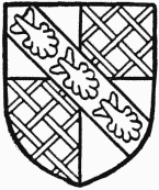
Spencer, Earl Spencer. Argent quartered with gules fretty or over all a bend sable with three scallops argent thereon.
On the south side of St. Martha's Hill stands the manor-house of Chilworth, which has an ornamental brick gable and porch. On the site of this was a cell belonging to the priory of Newark, and St. Martha's was probably always served by a canon resident here. Their large walled and terraced gardens and stewponds for fish still remain.
TYTING
TYTING (Tetinges, xi cent; Titing, xiii cent.) was held by Elmer the Huntsman before the Conquest, and afterwards became a possession of Bishop Osbern of Exeter, who had been chaplain to Edward the Confessor. (fn. 17) It was held by the successive Bishops of Exeter till 1548. In 1234–5 John le Chanu and his wife Katherine quitclaimed to William Bishop of Exeter Katherine's rights in a carucate of land in Tyting. (fn. 18) From time to time this manor was assessed among the Bishop's temporalities. (fn. 19) In August 1549 John Veysey, then Bishop of Exeter, sold the freehold to Thomas Fisher. (fn. 20) He shortly afterwards conveyed it to Henry Polsted, (fn. 21) whose son Richard, together with William Morgan, was in possession in 1571. (fn. 22) He married Elizabeth, daughter of Sir William More of Loseley, and had from him an assignment of a ninetynine years' lease which Sir William and Henry Weston are said to have acquired in February 1566–7. (fn. 23) Richard Polsted died in 1576, (fn. 24) and in the next year Francis Polsted alienated Tyting to Sir William More, probably as trustee for Elizabeth (Polsted), (fn. 25) but William Morgan's interest still continued, for in 1602 he died seised of lands and tenements called 'Titing.' (fn. 26)

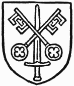
See of Exeter. Gules St. Paul's sword erect surmounted by St. Peter's keys crossed saltirewise.
Early in the same century both Sir George More, son of Sir William More, and Ann Randyll, granddaughter of William Morgan, joined with George Duncombe in a conveyance of the manor to John Astrete or Street, (fn. 27) who is said to have been holding the estate in 1602. (fn. 28) He was succeeded by his son John. (fn. 29) John Street and George Duncombe conveyed to Francis Williamson in 1637. He sold to Vincent Rundyn, and the latter to George Duncombe of Albury, who by his will of 1672 left in it trust for his family, Richard Symmes being one of the trustees. (fn. 30) Manning and Bray say that it was conveyed in 1710 to Abraham Woods, from the trustees of whose son William it came to Philip Carteret Webb, in 1747. From Mr. Webb it descended to his son, John Smith Webb, (fn. 31) who sold it to Robert Austen of Shalford, (fn. 32) in whose family it still remains.
CHURCH
ST. MARTHA'S Chapel
ST. MARTHA'S Chapel, (fn. 33) a wellknown landmark for all the country side, stands upon the summit of a ridge of Greensand, about 570 ft. above the sea. Although called a chapel, it seems always to have possessed the rights of a parish church; and it is probably to be identified with one of the three churches mentioned in Domesday as standing on the manor of Bramley, then held by Bishop Odo of Bayeux, who may well have built the original of the present building. The site itself is an extremely ancient one, and several circular earthworks still remain on St. Martha's Hill.
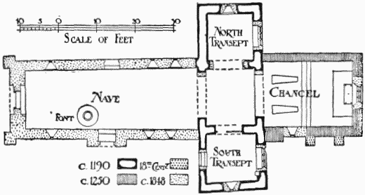
The building as we now see it is largely of modern date, an object-lesson of the mischievous results of fanciful restoration, the nave, which had long lain in ruins, being rebuilt in a pseudo-'Norman' style, and the chancel and transept largely reconstructed in 1848. The chancel and transepts had remained intact until about 1846, although the nave was a roofless ruin, and only fragments of the large west tower existed; but in that year part of the roof fell in and services were suspended. The then Lord Loraine co-operated with two other neighbouring county gentlemen, Mr. H. Currie, of West Horsley, and Mr. R. A. C. Godwin Austen, of Shalford, to rebuild the ruined nave and restore the eastern limb, the last fragments of the western tower being at the same time removed. This tower, which seems to have been very massive and large, is shown in ruins in the engraving published in Grose's Antiquities, from a sketch taken in 1763, (fn. 34) it having been thrown down by a severe explosion at the Chilworth gunpowder factories in that year. This view shows part of the vault (apparently a plain quadripartite one without ribs) as then existing, and beneath is a circular squareedged arch opening into the nave. The simple character of this arch, which was devoid of ornament except for a chamfered impost at the springing, suggests that it may have been part of Bishop Odo's work of the last decades of the 11th century; and a small round-headed window in the south wall of the nave, shown in Cracklow's view of 1824, coincides very well with this date. There seems to have been a plain early doorway in the north and south walls, features that together with the windows have been reproduced in some sort in the new work. The nave, built on the old foundations, measures 45 ft. in length by 15 ft. 1 in. at the west, and 16 ft. at the east; the central crossing, 12 ft. 6 in. by 13 ft. 6 in. wide; the north transept, 11 ft. 8 in. by 12 ft., and the south transept, 12 ft. 8 in. by 12 ft.; while the chancel is 23 ft. long by 16 ft. 8 in. The thickness of the present west wall (3 ft. 6 in.) represents that of the walls of the destroyed western tower. The transept and crossing walls are 2 ft. 3 in. on an average.

Plan of St. Martha's or Chilworth Church
The authority for the present central tower is very questionable, and in any case its 'Norman' style is out of keeping with the plain early pointed arches on which it stands, parts of which are original work of circa 1190.
Probably the first chancel was apsidal, and this square space represented the quire.
There is no window in the west wall of the north transept or the north wall of the chancel, and all the other windows are restorations. It is on record that foundations were discovered in the ground to the east of the transepts, probably those of chapels, perhaps apsidal. Three aumbries were found in the chancel, and two stone coffin-lids, with floriated crosses, much worn, were dug up, and now lie on the floor of the chancel. Two buttresses against the south wall of the chancel are probably not mediaeval, but a sort of buttress projection in the angle between that wall and the east wall of the south transept was possibly made to allow of a squint being pierced from the transept to command the high altar.
There is reason to believe that the barrel-shaped font, of sandstone, is the one described by Manning and Bray as at Elstead Church, whence it had disappeared before 1845. The St. Martha's font was brought 'from another church,' where it had been thrown out into the churchyard in 1849, and the carving added on the spot. The original was early Norman, like that at Thursley. (fn. 35)
The silver cup and paten bear the London hallmarks of 1780.
The bells are all modern.
An iron church in Chilworth hamlet was built in 1896 and is served from Shalford.
ADVOWSON
St. Martha's was probably one of the three churches appurtenant to Bramley in 1087, (fn. 36) and the advowson alienated by the lord of Bramley, at the time when Chilworth was granted out to the lords of Utworth, for Elias of Utworth (fn. 37) owned late in the 12th century, and granted it to the Priory of St. Thomas the Martyr at Aldebury. (fn. 38) The priory retained the advowson until its surrender in 1538. (fn. 39) In the episcopal registers of 1463 record is kept of an indulgence granted to pilgrims to, or benefactors of, the church of St. Martha and All Holy Martyrs. (fn. 40) After the surrender of the priory the advowson seems to have become the property of the lords of Chilworth Manor, with which it has since descended.
The church in 1291 is called ecclesia not capella, and the canons of Newark were endowed with all the usual parochial revenues in 1262. (fn. 41) They presented a vicar previous to 1330, (fn. 42) and as late as 1412. (fn. 43) Latterly it was a donative, probably from the time of the Dissolution, and an annuity was paid to a curate by the patron. The duty was usually done by the incumbent of some neighbouring parish or his curate. The registers are in consequence imperfect, entries being in existence in Wonersh, Albury, and elsewhere referring to St. Martha's; but there is a register with some entries of baptisms and burials from 1779, and of marriages from 1794. Since 1849 it has been attached to Albury, and the rector of Albury, the Rev. H. E. Crossley, was instituted by the Bishop of Winchester as rector of Albury and vicar of St. Martha's in 1904.
