A History of the County of Sussex: Volume 6 Part 1, Bramber Rape (Southern Part). Originally published by Victoria County History, London, 1980.
This free content was digitised by double rekeying. All rights reserved.
A P Baggs, C R J Currie, C R Elrington, S M Keeling, A M Rowland, 'Worthing: Growth of the town', in A History of the County of Sussex: Volume 6 Part 1, Bramber Rape (Southern Part), ed. T P Hudson (London, 1980), British History Online https://www.british-history.ac.uk/vch/sussex/vol6/pt1/pp97-103 [accessed 30 April 2025].
A P Baggs, C R J Currie, C R Elrington, S M Keeling, A M Rowland, 'Worthing: Growth of the town', in A History of the County of Sussex: Volume 6 Part 1, Bramber Rape (Southern Part). Edited by T P Hudson (London, 1980), British History Online, accessed April 30, 2025, https://www.british-history.ac.uk/vch/sussex/vol6/pt1/pp97-103.
A P Baggs, C R J Currie, C R Elrington, S M Keeling, A M Rowland. "Worthing: Growth of the town". A History of the County of Sussex: Volume 6 Part 1, Bramber Rape (Southern Part). Ed. T P Hudson (London, 1980), British History Online. Web. 30 April 2025. https://www.british-history.ac.uk/vch/sussex/vol6/pt1/pp97-103.
Growth of the town.
In the 18th century, and probably earlier, the hamlet of Worthing comprised the modern High, North, and Warwick streets. (fn. 1) There is some archaeological evidence for a settlement at the south end of High Street between the 13th and 16th centuries. (fn. 2) One building dated 1762, of flint with brick dressings, survived in High Street in 1945, (fn. 3) but in 1978 the earliest surviving houses there were of the early 19th century: a small group on the east side and one larger house in Upper High Street. Some buildings possibly of the 18th century survived in 1978 at the east end of Warwick Street. South of the hamlet, on the common which lay south of the modern shoreline, fishing 'shops' were recorded in the 18th century, as well as a building said to be a former court-house. (fn. 4) There may also have been an inn. (fn. 5) There seems also to have been scattered settlement further west, for the modern Victoria inn in Montague Street is perhaps 17th-century in origin. (fn. 6)
The building of lodging-houses at Worthing is recorded in the 1790s (fn. 7) but not their location. One grander house dated from the same period. In the 1780s (fn. 8) a marine villa was built at the south end of High Street on its east side, which after enlargement in 1790 for George Greville, earl of Warwick (d. 1816), (fn. 9) was known as Warwick House. During the early 19th century it was the principal house in Worthing, being let during the season to various distinguished visitors. (fn. 10) The building, which was demolished in 1896, was of flint with yellow brick dressings, facing south. Its original staircase survived in 1977 in a house in Warwick Street. (fn. 11)
Between 1798 and c. 1812 the town expanded very rapidly, (fn. 12) probably accounting for most of the threefold increase in the number of houses in Broadwater parish between 1801 and 1811, (fn. 13) and presumably fully meeting the need for extra accommodation expressed in 1802 and 1805. (fn. 14) Early development was around the modern Warwick, South, and Montague streets. The layout of streets was influenced by the direction of strips in the open fields which preceded them; those north of Warwick Street all ran east-west, and those south of Warwick and Montague streets north-south. (fn. 15) Bedford Row and Copping's Row, later Marine Place, south of Warwick Street, were built between 1802 and 1805, (fn. 16) and by 1804 there was at least one terrace facing the sea near by. (fn. 17) Ann and Market streets, north of Warwick Street, were recorded respectively in 1805 and 1811. (fn. 18) Meanwhile the Steyne had been laid out c. 1811, (fn. 19) twenty-three lodging-houses being built on its west side. (fn. 20) Some way to the east of the Steyne, and separated from it by open land, Warwick Buildings, later the east side of Warwick Road, were also in existence by 1811, (fn. 21) and Gravel or Greville Terrace to the south of it apparently by 1813. (fn. 22)
Development west of South Street, on both sides of Montague Street, then called Cross Lane, began at about the same time. Sumner or Summer Lodge, on the east side of Montague Place, was built c. 1800 or soon after, (fn. 23) and the west side of Montague Place was built between 1802 and 1805. (fn. 24) Further west King's Row and Prospect Place were recorded in 1807, (fn. 25) Prospect Row in 1810, (fn. 26) and Trafalgar Place, later Augusta Place, in 1811. Bath Buildings, later Bath Place, was also mentioned in 1811. (fn. 27) North of Montague Street, Chapel Street, later Portland Road, named after the Independent chapel at its southern end, was in existence by 1806, (fn. 28) and four years later contained tradesmen's premises and second-class lodging-houses. The first shops of the resort were chiefly in High and Warwick streets, the latter also containing banks and the post office; (fn. 29) by c. 1820 there were shops in South and Montague streets too. (fn. 30) Meanwhile at the north end of the old hamlet some houses were built at the same time in what was later the northern part of Chapel Road, including Worthing House, on the west side of the road, (fn. 31) which was let in the season to visitors. (fn. 32)
Apart from the area around Warwick Street, which was quite densely developed by 1812, much of the early development of the town was small-scale and scattered because of the fragmented ownership of land. (fn. 33) Later economic difficulties caused gaps between buildings and streets to be filled only slowly, giving a patchwork architectural effect to that part of the town. (fn. 34)
Worthing nevertheless continued to grow after 1812. (fn. 35) New houses and terraces were built south of Montague Street; by 1826 the built-up area there had reached West Buildings, and by 1843 it had almost arrived at the Heene-Broadwater boundary. (fn. 36) Some streets in that area, for instance Surrey and West streets, seem to have been built for lower-class occupation, and much of the area had become a poor quarter by c. 1840. (fn. 37) East of the Steyne York Terrace, later Warne's Hotel, and Warwick Place, north of Brighton Road, had been built by 1826, and Alfred Place was built between 1826 and 1843. (fn. 38) A little further east Beach House was built in 1820, with grounds stretching down to the sea (fn. 39) which later formed a barrier to the town's eastward development. An esplanade along the whole frontage of the town as it then existed was constructed between 1819 and 1821. (fn. 40)
At the same period the town began to expand to the north-west, along the ridge on the eastern part of which the hamlet of Worthing had grown up. Chapel Road, named after the chapel of ease opened in 1812, was cut after the inclosure of 1810 to bypass High Street, which it had replaced as the main entrance to the town by 1817. (fn. 41) Ambrose Place behind the chapel was built c. 1815, (fn. 42) while on the other side of Chapel Road Union Place was laid out by 1826 to link the chapel to High Street. (fn. 43) In the same area were Worthing's two grandest contemporary building developments. Liverpool Terrace, north of Montague Street, was built between 1826 and 1833, (fn. 44) facing Chapel Road across what remained open land until c. 1870, being laid out as pleasure grounds c. 1835. (fn. 45) Park Crescent, also built between 1826 and 1833, lay detached from the town, on the crest of the ridge and close to the Heene boundary. (fn. 46) Behind Park Crescent a terrace of houses called New Town was built, on the west side of what was later Clifton Road. (fn. 47) Some detached houses and a terrace had been built in Richmond Road by 1843, when there were also detached villas in Chapel Road near by. (fn. 48) Meanwhile the junction of Chapel Road with South and Warwick streets had become the centre of the town when the town hall was built there in 1835. (fn. 49)
Most of the surviving early-19th-century domestic architecture of Worthing is plain, with none of the exuberance of contemporary Brighton. Only a few traces remain of the original appearance of Warwick, South, and Montague streets, for instance curved bay-windows in the two first-named, facades in yellow brick with classical window heads in Warwick Street, and a building with Ionic pilasters in Montague Street. Terraces of lodging-houses, however, survive around those three streets. They are of three or four storeys, usually stuccoed, but occasionally displaying cream or yellow brickwork, as in the Steyne or Bedford Row. Many have curved bay-windows rising through their full height, for instance West Buildings, Bedford Row, Liverpool Terrace, and the west side of Montague Place, and many have balconies of wood or iron, often designed individually for each house. Some houses in Bedford Row have columned porches, but only two terraces, namely York Terrace, later Warne's Hotel, and Caledonian Place, in West Buildings, display pilasters. At Ambrose Place, Warwick Place, and Bedford Row there are detached front gardens on the opposite side of the roadway; those belonging to the houses in Bedford Row were mostly used for car-parking in 1978. Four-storeyed lodging-houses formerly also existed in High Street. (fn. 50)
The Hollies in upper High Street is of three bays in yellow brick with relieving arches enclosing two storeys. Beach House, by J. B. Rebecca, (fn. 51) shares the classical idiom of Liverpool Terrace; the main portion is of three bays and two storeys, stuccoed, with a curved central projection in its southern façade. Other detached stuccoed houses survive in Union Place and Richmond Road. One of the latter is of 5 bays, symmetrical, with a three-bay pediment, another is asymmetrical classical, and a third is a cottage ornée in the Elizabethan style. In Grafton Road to the south is another contemporary cottage ornée. (fn. 52) The grandest piece of architecture of the period, Park Crescent, combines terraced with detached housing, a south-facing crescent, serpentine in plan, and with giant pilasters of unusual design, being complemented by ornamental grounds containing a pair of cottages ornées, and by a massive gateway with herms fronting Richmond Road. Only part of the original scheme was executed, (fn. 53) the architect being A. H. Wilds of Brighton. (fn. 54) Smaller contemporary terraces, of two or three storeys, may be lodging-houses or working-class dwellings. They are usually stuccoed, but sometimes, as in Portland Road or Prospect Place, partly faced with cobbles, and sometimes not to a uniform design, as in Portland Road or Warwick Place. Some houses in Alfred Place, Portland Road, and Warwick Place have projecting enclosed porches with ogee heads, locally known as 'boat porches'.
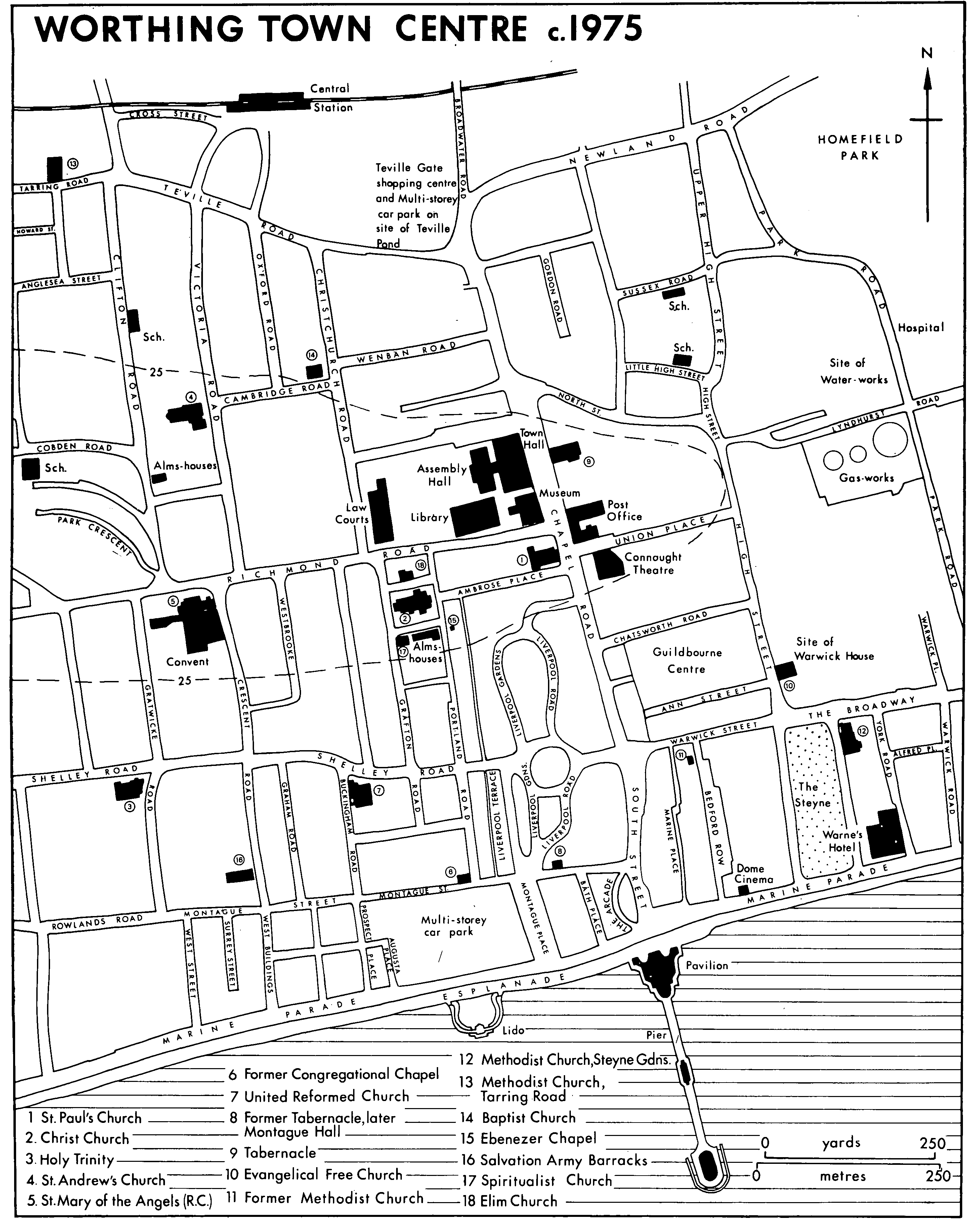
Worthing Town Center c.1975
Despite its sanitary problems the town continued to expand in the mid 19th century; between 1841 and 1871 the number of houses increased from 1,028 to 1,471. (fn. 55) The infilling of new houses and streets continued along the sea front west of South Street. East of South Street, on the other hand, much land remained open; the north part of York Road and the west side of Warwick Road were not built until the 1880s or 1890s, (fn. 56) and the east side of the Steyne was not filled until c. 1900. (fn. 57) After c. 1860 the area around South Street, the east end of Montague Street, and the pier, built in 1862, became the entertainment centre of the town, while the area north of Warwick Street became more commercial. Chapel Road was further built up between the 1840s and 1870s, (fn. 58) and between 1866 (fn. 59) and 1875 (fn. 60) the open space between it and Liverpool Terrace was filled by an asymmetrical development of detached stuccoed villas along curved roads.
The expansion of residential streets continued westwards on the south-facing slope of the low ridge marked by Richmond Road. (fn. 61) Crescent Road, laid out in the 1830s (fn. 62) to link Park Crescent to the town, was built up with large houses, as was Westbrooke to the east of it, and the area north of Park Crescent was filled with smaller houses. As before, the alignment of new streets was influenced by that of the previous open-field strips. By 1875 building north of Montague Street had reached the Heene boundary, being abruptly halted there by the market-garden land which lay beyond. (fn. 63)
During the next twenty years the west end of the town was built up northwards as far as the railway, which had been opened in 1846. The largest area to be developed at that time was the Gratwicke estate, around the modern Shelley Road, which was built up between 1877 and 1884 (fn. 64) with detached and semi-detached houses, many quite large; most were stuccoed, in classical style, but some displayed the red brick and tiles of the more up-to-date revived vernacular style. North of that estate Christchurch, Oxford, Cambridge, and Victoria roads were built in the 1880s, on a less grand scale, but with similar building materials and a similar mixture of detached and semi-detached houses; there is also a red-brick terrace in Christchurch Road. There had been some building between the north part of Chapel Road and the railway station before 1875, for instance along Teville Road, the beginning of the old road to West Tarring. During the last quarter of the century a small commercial area was developed south of the station, (fn. 65) while the low-lying land further west between Tarring Road and the Teville stream was laid out between the 1870s and the 1890s as a lower-class area with small terraced houses. (fn. 66)
Expansion continued westwards after c. 1900, absorbing the old village centre of Heene and the resort of West Worthing, which had been added to the town at its incorporation in 1890. By 1909 the former east field of Heene was fully built over, and development was progressing north and west of Heene church, with widely spaced detached and semi-detached houses among trees. Many of the streets in West Worthing laid out up to 40 years before, however, remained undeveloped or occupied by market-gardens, (fn. 67) and Grand Avenue marked the western edge of the built-up area c. 1914. (fn. 68)
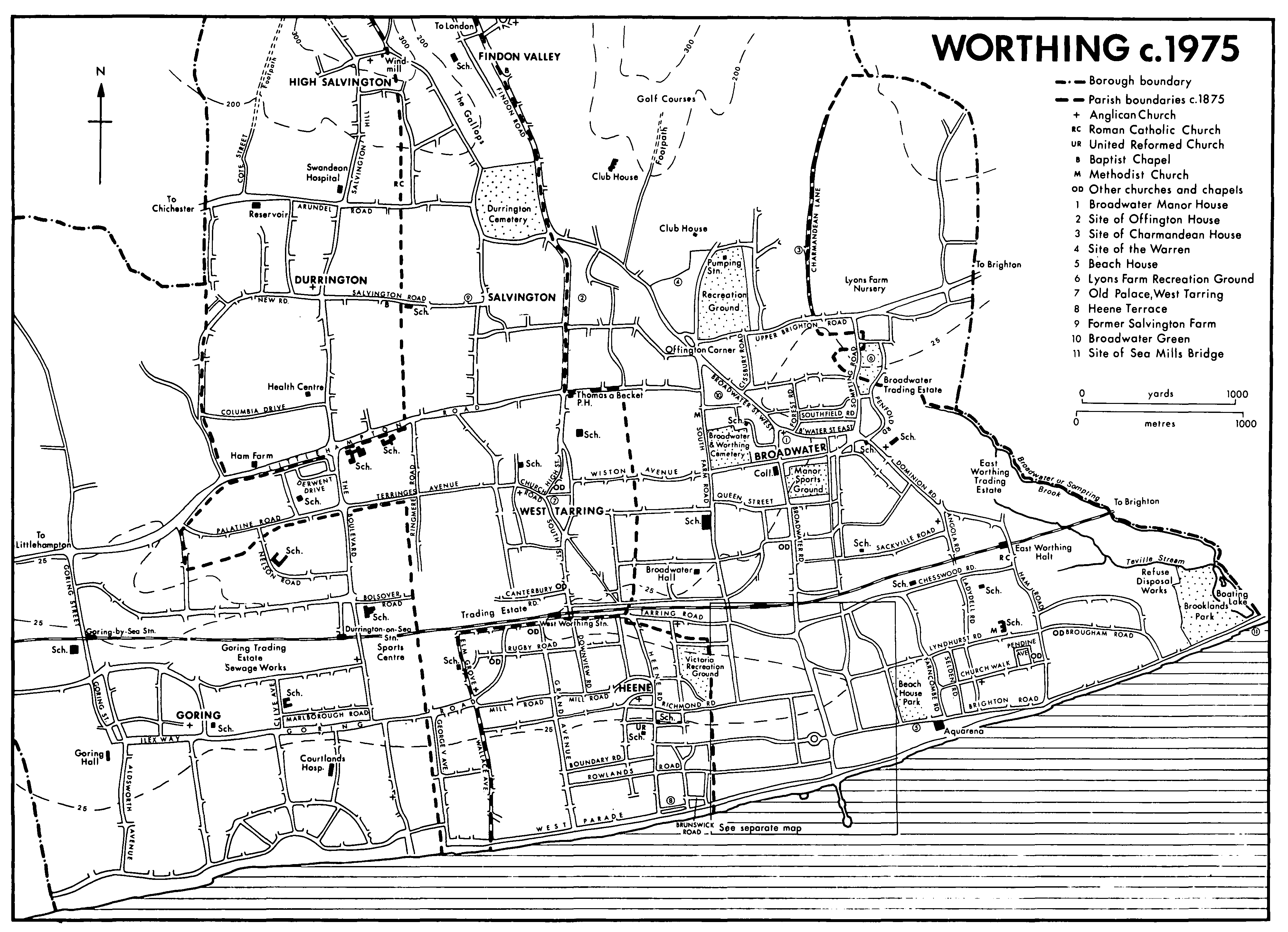
East of the town the gas-works had been opened in 1834 in Lyndhurst Road, and there was some building near by in 1843. (fn. 69) Some streets of poorer houses south-east of the railway bridge beside the Broadwater road had been built by 1875, (fn. 70) and more followed in the 1880s and 1890s. (fn. 71) The eastern side of the town, however, was very much more slowly developed for building than the west. One reason was its liability to flooding, which was increased after the breaches in the coast road after 1867. (fn. 72) Another was the proliferation of industrial uses near the railway and the gas-works, coupled with the prevailing westerly wind. In 1875, besides the water-works, there were two saw-mills and a whiting and putty works in that area. Only one area of residential development east of the town was comparable in character to the grander areas in the west, the tree-lined Farncombe Road, comprising large detached stuccoed houses on either side of a wide and serpentine roadway, which was in existence by 1875. (fn. 73) Other roads laid out before that date, for instance Chesswood Road and Church Walk, remained largely unbuilt on, much of the land along them being used for market-gardens. (fn. 74) The area round St. George's church, consecrated in 1868, was still not fully built up in 1909, (fn. 75) and the eastern side of the town remained dominated by market-gardens, with their glass-houses and windpumps, until after the Second World War. (fn. 76) In 1978 the long-drawn-out process of building development there could be deduced from the varied character of the architecture, for instance around St. George's church or in Chesswood Road, where a few mid19th-century houses were surrounded by many 20th-century ones.
North of the railway line some large houses, including one of c. 1840, had been built west of Broadwater Road, and at least one road had been marked out, by 1859. (fn. 77) By 1896 there were two or three streets of houses there, but much of the land between Worthing and Broadwater was occupied by market-gardens. In 1909, despite further building between the two places, Broadwater village remained physically separate from Worthing, though it was beginning to acquire its own new streets on the north, among them Southfield and Cissbury roads. By the same date new streets north of West Worthing station had linked West Tarring village to West Worthing, and building was also going on north of the village. Durrington and Salvington hamlet, however, were dominated by market-gardens, with only a few new houses of the poorer kind, (fn. 78) and an attempt to sell land along the road to Findon for building in 1907 was not successful. (fn. 79)
The years around 1900 saw many changes in the appearance of the town centre, as Chapel and Richmond roads were widened, (fn. 80) and new shops and commercial buildings began to replace the older buildings in Montague, Warwick, and South streets. (fn. 81) Warwick House was demolished in 1896, (fn. 82) and the grounds, which had been unsuccessfully offered as building land in the 1880s, (fn. 83) were built over by 1909. (fn. 84) Some trees at the south end were retained as a central feature in the widened Brighton Road renamed The Broadway, where a row of shops was built in 1901; the trees, however, were cut down in 1928. (fn. 85)
In the 1920s and 1930s the town expanded faster than ever before, the number of structurally separate dwellings occupied in the modern borough area increasing by c. 4,000 between 1921 and 1931, and by c. 10,000 between 1931 and 1951, to a total of 21,648. (fn. 86) The corporation exercised its powers to control development under the Town Planning Acts of 1919, 1925, and 1932, establishing density restrictions and zones for shopping and for professional and commercial use. (fn. 87) It also saw to the planting of trees along many roads. (fn. 88) By 1932 building had spread northwards to engulf Broadwater village, and to link it to West Tarring. Tarring for its part was linked by building, more tenuously, to Durrington and Salvington, where some new houses had been built. (fn. 89) During the 1930s building continued in those areas, (fn. 90) both of privately owned houses, and of council houses, for instance south-east of Broadwater and north of the Durrington-Salvington road; (fn. 91) in 1947, however, the environs of Durrington and Salvington were still dominated by market-gardens. (fn. 92)
Two large areas developed at the same period were the former parks of Offington and Charmandean houses. The south part of Charmandean park, north of Broadwater, was developed from 1926 (fn. 93) and the north part after 1955. (fn. 94) Part of Offington park, between Broadwater and Salvington, was developed after c. 1928 and the rest after 1935. (fn. 95) The combination of large detached houses in very varied styles, many trees, and at Charmandean a south-facing slope, made the areas two of the best residential districts of the town, (fn. 96) which they remained in 1978. The largest areas of development, however, were further afield. West of the town centre building had passed the old borough boundary at George V Avenue by 1932, (fn. 97) and most of the remaining market-gardens in West Worthing were replaced by houses and flats during the 1930s. (fn. 98) After the incorporation into the town of the predominantly rural parish of Goring in 1929 its southern part began to be rapidly built up on a large scale. (fn. 99) Most of the land south of the railway had been laid out with roads by 1938, when much building was in progress, especially west of George V Avenue, (fn. 100) and on the Goring Hall estate west of the church, which became another of the town's best residential areas, many trees being retained, notably the ilex avenue between the church and the hall. (fn. 101) In the north-west of the borough development spread for the first time north of the Chichester -Brighton road. At High Salvington after 1923, (fn. 102) despite the protests of preservationists, (fn. 103) a straggling development including many large detached houses of various styles spread up to the summit of the hill, which is over 300 feet high. Many old trees and banks were retained, especially in Salvington Hill. To the north-east in Findon Valley, added to the borough in 1933, development proceeded rapidly during the 1930s on either side of Findon Road, with wide streets of detached and semi-detached houses and bungalows. (fn. 104)
Worthing c.1975
Meanwhile the older suburbs west of the town centre, and Farncombe Road to the east, remained wealthy residential areas, though some houses there were beginning to be turned into hotels, institutions, or flats. In the centre of the town hotels and boarding-houses continued to occupy much of the sea front and the area behind it. Some new shops and commercial buildings were appearing in South Street, the shopping centre of the town, (fn. 105) which was partly widened in 1924, when the Arcade was built at its southern end. (fn. 106) The southern part of Chapel Road was occupied by shops and businesses by 1927, (fn. 107) and at about the same date the detached houses of the northern part in their leafy gardens were being replaced by new offices and public buildings (fn. 108) like the town hall and post office, while offices also began to invade the area of large 19thcentury houses to the west. (fn. 109) High Street to the east, by now superseded as the spine of the town, had taken on the industrial character of the land around it to the east and north. (fn. 110)
After the Second World War most of the surviving market-gardens in the south-east part of the town, west of Broadwater Road, and around West Tarring, Salvington, and Durrington were replaced piecemeal by streets or closes of houses. At the same time many large houses in the older suburbs were converted into flats or institutions, or replaced by small closes or blocks of flats. (fn. 111) The largest remaining area of building land was in the west part of the borough, in the former parish of Goring and around Durrington station, opened in 1937. Between the 1950s and 1970s that land was rapidly developed, (fn. 112) with a large number of council houses (fn. 113) as well as privately owned ones; building was still going on in Durrington in 1978. (fn. 114) In addition much land in that area was used for schools and recreation grounds, while near Durrington station several tall office blocks were built. In 1978, apart from the area occupied by recreation grounds or the various trading estates, at Broadwater, East Worthing, West Worthing, and Goring, most of the land within the borough was built on. The only large areas not developed were the downland in the north-west and north-east used for agriculture or as open space, especially for golf courses, (fn. 115) and land in the west between Durrington and Highdown Hill (in Ferring). Along the coast both the eastern and western boundaries were marked by a slight hiatus in the built-up area that extends from Littlehampton to Brighton.
The centre of the town had meanwhile undergone great changes. The area west of Chapel Road had come to be dominated by offices and administrative buildings: some new office buildings had been built in Liverpool Gardens, and a new library and law courts in Richmond Road, and many large 19thcentury houses in the same area had been converted for office use. Most of the older buildings in High Street were demolished after c. 1950, (fn. 116) and the construction of the Guildbourne centre between Chapel Road and Warwick Street in 1974, (fn. 117) comprising shops, flats, offices, and a multi-storey car park, brought about the destruction of part of the early-19th-century town, including the Ann Street theatre, 'a very precious survival'. (fn. 118) The town's focus, the old town hall, was demolished in 1966. (fn. 119) Some of the older streets south of Montague Street had also been destroyed or blighted since the Second World War, Montague Street being made a pedestrian shopping precinct during the 1970s. (fn. 120) Other large multi-storey car parks were built on the sea front (fn. 121) near by, and near the Broadwater Road railway bridge. The sea front, however, in accordance with a long-standing policy, remained free from large-scale commercial development.