A History of the County of Sussex: Volume 6 Part 2, Bramber Rape (North-Western Part) Including Horsham. Originally published by Victoria County History, London, 1986.
This free content was digitised by double rekeying. All rights reserved.
A P Baggs, C R J Currie, C R Elrington, S M Keeling, A M Rowland, 'Sullington', in A History of the County of Sussex: Volume 6 Part 2, Bramber Rape (North-Western Part) Including Horsham, ed. T P Hudson (London, 1986), British History Online https://www.british-history.ac.uk/vch/sussex/vol6/pt2/pp18-20 [accessed 30 April 2025].
A P Baggs, C R J Currie, C R Elrington, S M Keeling, A M Rowland, 'Sullington', in A History of the County of Sussex: Volume 6 Part 2, Bramber Rape (North-Western Part) Including Horsham. Edited by T P Hudson (London, 1986), British History Online, accessed April 30, 2025, https://www.british-history.ac.uk/vch/sussex/vol6/pt2/pp18-20.
A P Baggs, C R J Currie, C R Elrington, S M Keeling, A M Rowland. "Sullington". A History of the County of Sussex: Volume 6 Part 2, Bramber Rape (North-Western Part) Including Horsham. Ed. T P Hudson (London, 1986), British History Online. Web. 30 April 2025. https://www.british-history.ac.uk/vch/sussex/vol6/pt2/pp18-20.
SULLINGTON
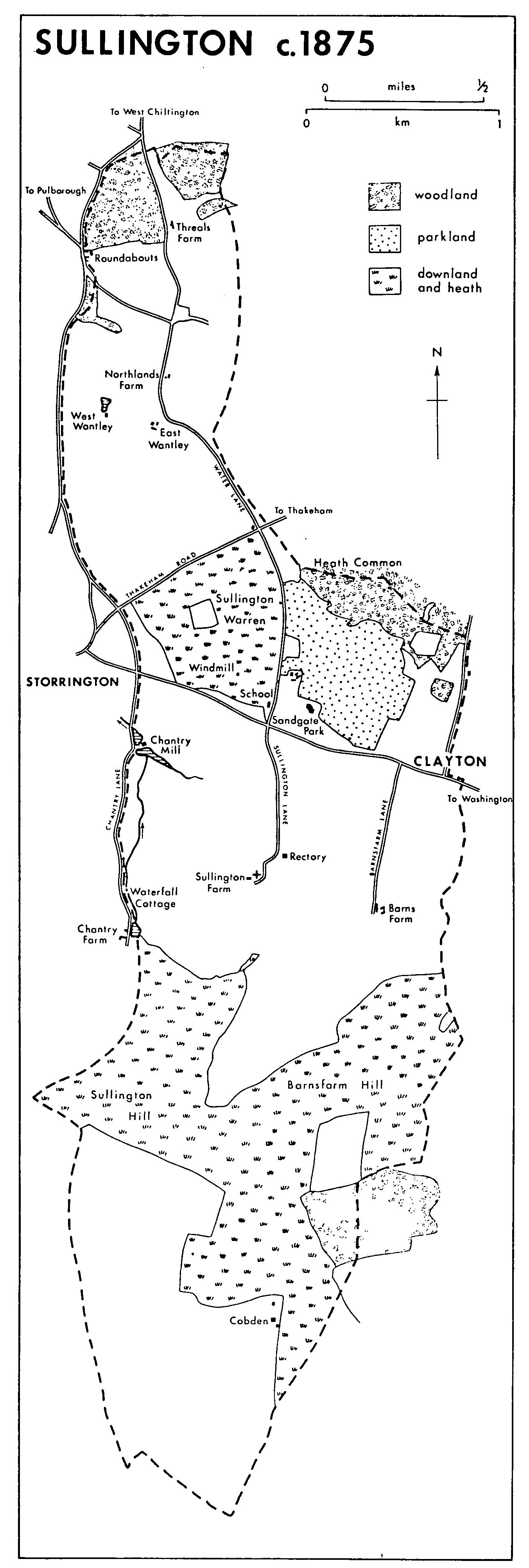
SULLINGTON lies on and below the northern scarp of the South Downs, 7½ miles (12 km.) NNW. of Worthing. The ancient parish covered 2,338 a. (fn. 1) Of that, 120 a. lay in two detached parts at Broadbridge and Broadbridge Heath, respectively 2 miles WSW. and 2 miles WNW. of Horsham and more than 9 miles from the rest. The detached parts evidently represent Sullington's Wealden pasture. Both were transferred to Horsham parish in 1878. (fn. 2) The history of Broadbridge Heath is treated under Horsham. The remaining part of the parish, covering 2,218 a. (898 ha.), is long and narrow, 4½ miles from north to south by at most 1¼ miles from east to west. In the south the boundaries were undefined; further north the western boundary follows lanes and the eastern boundary lanes and field hedges.
Broadbridge and Broadbridge Heath lie mainly on Weald clay. (fn. 3) The main part of Sullington spans the strata which underly the rising ground at the edge of the Weald. The northern end, at a height of c. 100 ft. (30 metres), overlies Hythe and Sandgate beds with an inlier of Weald clay at Wantley. The centre lies on Gault clay and Upper Greensand. In the south the ground rises to the top of the chalk escarpment, reaching 649 ft. (148 metres) and 675 ft. (205 metres) respectively on the twin peaks of Sullington and Barnsfarm Hills, and then slopes gently into the coombes on the south side of the downs, the southern tip of the parish being at c. 300 ft. (91 metres). (fn. 4)
A Roman road crosses the north end of the main part from east to west, leaving the parish at Roundabouts. (fn. 5) A south-north route across the parish follows Sullington and Water lanes as far as Heath common. There it divided into two, one branch leading to West Chiltington by Water, Northlands, and Threals lanes across Eastbridge, just north of the parish boundary but a responsibility of Sullington tithing in 1538, (fn. 6) the other branch leading to Thakeham. The route may have formed part of a drove road from Ferring to Horsham (fn. 7) and may be the road from Thakeham to Sullington mentioned in 1229. (fn. 8) Threals and Northlands lanes were no longer thoroughfares in 1983. Sullington Lane may have been the causeway of Sullington for whose repair money was left in 1557. (fn. 9) Two other lanes running parallel with it, Barnsfarm Lane from Barnsfarm Hill to Clayton on the east, and Chantry Lane on the western boundary, may also have been early drove roads. The parish is crossed near Clayton by the road from Pulborough to Washington, turnpiked in 1810. (fn. 10) The stretch near Sandgate park was diverted to the south in 1828 at the application of G. J. Gibson, owner of the park. (fn. 11) The road was disturnpiked in 1877. (fn. 12) The road from Thakeham to Storrington, turnpiked in 1824, (fn. 13) crosses the parish north of Sullington Warren.
Newbridge, which took the road from Broadbridge Heath to Billingshurst across the Arun, was maintainable by Broadbridge farm (in Broadbridge) in 1615, (fn. 14) and by the inhabitants of Sullington tithing and others in the 18th century. (fn. 15)
Sullington c.1875
Neolithic settlement in the parish may be indicated by finds of arrowheads and by a long bank and ditch across the spur of Sullington Hill. (fn. 16) Bronze Age bowl barrows have been recorded there and on Sullington Warren; a cinerary urn was discovered in a barrow at the Warren opened in 1809, and a burial or cremation was found on Sullington Hill in 1940. (fn. 17) What were presumably Bronze Age spearheads and swords were found in 1812 north of Sandgate. (fn. 18) It has been suggested that Cobden, in the south end of the parish, is a Celtic site, (fn. 19) and allegedly Roman house sites were found at Chantry Bottom on the western boundary in 1919. (fn. 20)
Settlement remained scattered until the 20th century. The name Sullington may describe a settlement in a hollow near the western boundary. Pre-Conquest references to 'Sillinctune' probably mean Chollington in Eastbourne. (fn. 21) The church, whose earliest parts are of c. 1000, stands on the Upper Greensand, on the spring line: it is surrounded on three sides by the manor farmstead, and the old rectory lay c. 300 metres to the north-east. There is no evidence of a village. A mill on the western boundary existed in 1086. (fn. 22) Cobden in the south, a separate settlement with its own inclosed fields, existed by 1473; (fn. 23) an alleged deserted medieval village there (fn. 24) may be the same site as the suggested Celtic site mentioned above. Later there is evidence of no more than the farmhouse and of some cottages destroyed in the Second World War. (fn. 25) East of the church Barns Farm existed by 1623, (fn. 26) and ½ mile further north there was settlement at Clayton by the 13th century; (fn. 27) Court Barton on the main east-west road there is 17thcentury, and in the late 18th century there were a few scattered houses along the road. (fn. 28) A cottage at Sandgate was mentioned in 1661; (fn. 29) two cottages and Sandgate Lodge north of the road were built there in the 1790s. The park round the house, including lodges and cottages, was created in the 19th century. (fn. 30) A school was opened west of the Thakeham road in 1866. (fn. 31)
Those settlements were separated by the wastes of Sullington Warren and Heath common from an area of scattered farmsteads to the north. Wantley was mentioned in 1296; there were two farms there probably by 1327 and certainly by the 15th century. (fn. 32) Roundabouts was mentioned in 1686. (fn. 33) The present Roundabouts farmhouse, which has a traditional three-roomed plan with internal chimney, was built in the 18th century. Threals was mentioned in 1691, (fn. 34) and Northlands in 1626, (fn. 35) and Leather Bottle Cottage, formerly an inn, at the corner of Water Lane and Thakeham Road, is early 17th-century. At Threals and Northlands the farmhouse had been demolished by 1876. (fn. 36)
There was little new building until after the First World War, when about half Sandgate park was sold for building plots (fn. 37) and an area round Sullington Warren and in the far north of the parish were developed as part of the growth of Storrington and West Chiltington respectively. In 1923 the rector recorded that many buildings 'of a superior description' were going up at the corner of Chantry Lane, while Sullington Warren was 'being rapidly fringed in a north-westerly direction by a heterogeneous class of dwelling, mostly of a bungalow type.' (fn. 38) By the Second World War the Warren estate north of Chantry Lane, and Marley Way south of Thakeham Road, had been built up; houses spread northwestwards along Fryern Road on the western boundary, and the rural district council built Warren Hamlet north of Thakeham Road. Grove Lane, Bower Lane, and Birchtree Lane were laid out north of Roundabouts. (fn. 39) Building round the Warren encouraged moves to preserve it, and 28 a. were bought by the National Trust in 1935. (fn. 40) Another 35 a. were bought by the rural district council in 1959, and another 16½ a. c. 1973. (fn. 41) In 1939-40 an army camp was built south of Barns Farm; it was used c. 1950 as a resettlement camp for Poles and others. (fn. 42) Building continued after the war in the same areas as before and along Storrington Road, but there were still few houses south of the main road in 1983. In the 1970s an industrial estate and some isolated small factories grew up along Water Lane.
The detached part of the parish at Broadbridge was a manor by 1243; (fn. 43) the hamlet consisted of a manor house, of which part dating from the 15th century survived in 1983, a mill, and by 1840 a cottage. (fn. 44)
There were 21 taxpayers in Sullington in 1327, and 23 in 1332. (fn. 45) What was presumably Broadbridge contained 10 recorded houses in 1665, when Sullington tithing contained 21. (fn. 46) A total of 90 adults was recorded in the parish in 1676, (fn. 47) and there were c. 25 families in 1724. (fn. 48) The population, 256 in 1801, remained roughly constant until the 1870s apart from a brief peak of 320 in 1831. After the removal of Broadbridge and Broadbridge Heath, with 77 inhabitants in 1811 and 108 in 1891, the population fell from 246 in 1871 to 200 in 1881; it then fluctuated for forty years between a maximum of 212 in 1891 and a minimum of 149 in 1901. From the 1920s numbers rose rapidly from 178 in 1921 to 922 in 1951, 1,354 in 1961, and 1,564 in 1971. In 1981 2,225 were usually resident. (fn. 49)
Leather Bottle Cottage served at some date before 1812 as the Duke's Head inn. (fn. 50) Either before that or in the earlier 19th century it was apparently the Leather Bottle inn, (fn. 51) but no inn was recorded after 1855. (fn. 52)
The Gibson family of Sandgate established benefit clubs in Sullington: a Sullington clothing club and a Sullington and Sandgate provident club in 1865 and a children's clothing club in 1874. (fn. 53) The rector played in a village cricket team in 1873, (fn. 54) and a cricket match was held on ice on Chantry mill pond in 1890. (fn. 55) After the school had been closed it was used from 1917 as a parish room, (fn. 56) and was the venue for plays and choral evenings put on by Sullington Merrymakers between 1927 and 1930. (fn. 57) A village hall was built in the 1950s and replaced by a new hall on an adjoining site in 1984. (fn. 58) Clubs in the early 1980s included youth clubs and the Vipers football club. (fn. 59)
The Sussex Road Car Co.'s steam bus service between Pulborough and Worthing served Sullington from 1905; (fn. 60) a carrier passed through the village until 1930. (fn. 61) A community minibus served the village from 1979. (fn. 62) Electricity for nearby houses was generated at Chantry mill from 1921 to 1928 or later. (fn. 63) Mains electricity was brought to the Heath common area in 1937, and mains water in 1938. (fn. 64)