A History of the County of Warwick: Volume 7, the City of Birmingham. Originally published by Victoria County History, London, 1964.
This free content was digitised by double rekeying. All rights reserved.
'Communications', in A History of the County of Warwick: Volume 7, the City of Birmingham, ed. W B Stephens (London, 1964), British History Online https://www.british-history.ac.uk/vch/warks/vol7/pp25-42 [accessed 30 April 2025].
'Communications', in A History of the County of Warwick: Volume 7, the City of Birmingham. Edited by W B Stephens (London, 1964), British History Online, accessed April 30, 2025, https://www.british-history.ac.uk/vch/warks/vol7/pp25-42.
"Communications". A History of the County of Warwick: Volume 7, the City of Birmingham. Ed. W B Stephens (London, 1964), British History Online. Web. 30 April 2025. https://www.british-history.ac.uk/vch/warks/vol7/pp25-42.
In this section
COMMUNICATIONS (fn. 1)
Roads
Birmingham's position on the edge of the sandstone ridge overlooking the marshy valley where the Rea and Tame meet is thought to have made the town a centre of local communications from an early date. The most convenient crossing of the Rea was at its nearest point to Birmingham. The sandstone ridge provided a practicable route between the centres to the south-west - Worcester, Droitwich, and Bromsgrove - and Lichfield and Tamworth to the north-east; roads converged from the south-east to cross the Rea between Digbeth and Deritend; and the gravelly, largely uncultivated land to the north-west of Birmingham allowed the establishment of many easy tracks to the towns and villages of south Staffordshire. (fn. 2)
The only Roman road passing near Birmingham was the Icknield Street or Rycknield Street, (fn. 3) and its existence had little bearing, if any, on the development of Birmingham. Only small fragments of the street in the immediate neighbourhood of Birmingham seem to have survived into the Middle Ages, though longer stretches are to be seen in Staffordshire, Worcestershire, and south Warwickshire, and the line of the street which still exists in Sutton Park extended, until the middle of the 19th century, for about a mile into Perry Barr. (fn. 4) Modern roads in the county borough of Birmingham which follow the course of the street are Lifford Lane, the Pershore road at Stirchley, (fn. 5) Great Hampton Row, and Wellhead Lane. The street, which ran between Bourton on the Water (Glos.) and Templeborough (Yorks.), crossing the Watling Street at Wall (Staffs.), entered King's Norton parish from Beoley and, crossing the Rea at Lifford, ran in a straight line until it reached the high ground near Selly Oak. There it made a quarter turn to the east, and followed a straight course towards Wall, crossing the Tame at Holford, a few hundred yards east of Perry Bridge. The theory that the Rycknield Street made a circuitous westward bend as it passed Birmingham is no longer accepted. (fn. 6) Another road, from Droitwich through Bromsgrove to Birmingham, may have been a Roman road joining the Rycknield Street at King's Norton; (fn. 7) it is, however, more commonly regarded as an ancient saltway. (fn. 8)
Of the crossings of the Rea near Birmingham, three were on routes to Aston church from parts of Aston parish on the far side of the Rea. One connected Watery Lane with the modern Vauxhall Road, on the line of the present Lawley Street, (fn. 9) the second was at Saltley, and the third, still called Aston Church Road, crossed between Washwood Heath and Holborn Hill. Probably none of these was as satisfactory as the crossing between Deritend and Digbeth: the inhabitants of Deritend and Bordesley, whose route to their parish church was by the Watery Lane crossing, (fn. 10) were given permission in 1381 to build their own chapel on the ground that the river was often impassable, (fn. 11) and in the early 16th century the inhabitants of Ward End, whose route was by Aston Church Road, were given similar permission for the same reasons. (fn. 12) At Deritend the river split into two arms, and was apparently fairly easy to ford. (fn. 13) Encroachment on the road through Deritend was reported in 1276. (fn. 14) From the Deritend crossing of the Rea local routes radiated out to Stechford, to Yardley by way of the New Bridge, and to Moseley. These roads were mentioned in 1337, (fn. 15) c. 1460, (fn. 16) and 1511 (fn. 17) respectively. The route from Birmingham to Edgbaston was by Edgbaston Street, Holloway Head and Wheeleys Road; forms of these names occur respectively in 1449, (fn. 18) 1553, (fn. 19) and 1511, (fn. 20) and the name Wheeleys Road suggests that the route led on to Weoley Castle. (fn. 21) Roads to Harborne and Halesowen led from Five Ways, so named in 1565. (fn. 22)
On the Staffordshire side of Birmingham, where there were large stretches of uncultivated heath and no rivers difficult to cross, there were probably many tracks leading to the neighbouring towns and villages. The soil of the area is such that it allowed the development of routes which did not need to be well defined or carefully established. (fn. 23) It was only with the growth of the heavy coal traffic that the condition of the roads in the area began to present any problem, and the routes were possibly not all precisely fixed until inclosure (fn. 24) and building (fn. 25) limited their courses. Summer Lane, leading in the direction of Perry and Walsall, was named in 1260. (fn. 26) A lane leading towards Dudley was mentioned in 1565. (fn. 27) About 1460 a route through Witton towards Oscott crossed the Tame at 'le Foulford', (fn. 28) where Witton Bridge was later built. To the north-east, the route towards Erdington and Sutton Coldfield crossed the Tame by Salford Bridge, in existence by 1290. (fn. 29) The route from Birmingham to Ward End and Castle Bromwich probably went through Saltley: this road was probably that mentioned in deeds of 1250 and 1340. (fn. 30) Another route through Saltley led from the northern end of Birmingham to Stechford, entering the hamlet from the north over Stechford Bridge.
In Birmingham's medieval history these local routes are probably more important than roads from farther afield. Letters patent were dated at Birmingham in 1235 when the king was travelling from Lichfield to Worcester, (fn. 31) and again in 1486 when the king was travelling from Nottingham to Worcester. (fn. 32) On each occasion the route was presumably through Bromsgrove, and Droitwich along the road from Birmingham to Worcester already referred to as a probable ancient saltway; between Bromsgrove and Droitwich it appears to have been a carriageable road in the 10th century, (fn. 33) and the erection of a mill at Bromsgrove in 1273 was said to have interfered with the king's highway there. (fn. 34) The route from Lichfield to Birmingham may have been either through Sutton Coldfield, where a highway was mentioned in 1176, (fn. 35) or through Perry, for a man travelling to Lichfield from south of Birmingham c. 1379 alleged that a bridge across the Tame in Handsworth parish lay on his direct route. (fn. 36)
Of the roads which converge on Birmingham from the south-east to cross the Rea by Deritend Bridge, two were mentioned as passing through Yardley in 1282. These were probably the roads to Coventry and Stratford-on-Avon. (fn. 37) The road to Coventry was carried over the Blythe by Stone Bridge, which was in existence in 1299, (fn. 38) and from Stone Bridge a road running south to Kenilworth and Southam crossed the Avon by Chesford Bridge, mentioned in 1279. (fn. 39) The road to Stratford is thought to have existed in the Anglo-Saxon period, (fn. 40) and from it the road to Warwick branched off through Lapworth and Lowsonford. (fn. 41) There may have been an alternative route to Warwick through Solihull and Knowle, (fn. 42) but the most commonly used route in the 17th century and earlier seems to have been through Rowington. (fn. 43)
From the mid-15th century there is evidence of a road from Birmingham to Coleshill, (fn. 44) and it was possible to continue on towards Atherstone, crossing the Blythe by Blythe Bridge, mentioned in 1382, (fn. 45) and the Bourne by a 14th-century bridge between Shustoke and Over Whitacre. (fn. 46) On the other side of Birmingham routes may be assumed to have led towards Kidderminster and Stourbridge, towards Bridgnorth through Dudley, (fn. 47) and towards Wolverhampton through Walsall, passing over Hamstead Bridge. (fn. 48)
The condition and congestion of these roads became a serious problem as traffic increased, and this problem was to some extent met in successive periods by turnpiking, by the building of canals, and by the coming of the railways. It has been said of Birmingham that no town in England derived more benefit from turnpike roads and canals. (fn. 49)
The roads leading north-west out of Birmingham, which had the natural advantage of comparatively favourable terrain, (fn. 50) began to bear heavy traffic with the increase in the carriage of coals and iron, and as their use increased their condition deteriorated. A deed of 1612 mentions the 'great way' from Perry Bridge to Birmingham. (fn. 51) In 1642 Charles I used the road through Wolverhampton and Birmingham on his way from Shrewsbury to Edge Hill, instead of travelling on the route through Worcester. (fn. 52) In 1727 the road from Birmingham to Dudley was said to be greatly used for the carriage of iron goods, coal, and lime, (fn. 53) and the road to Wolverhampton to be impassable as a result of the damage done by the carriage of iron and coal. (fn. 54) In 1781 Hutton described the Walsall road, which went by Handsworth church, as 'rather below indifferent', and the Dudley road as 'despicable beyond description'; the Wolverhampton road, he said, had greatly improved because the coal traffic had moved to the canal, (fn. 55) and he recorded in 1806 that the Walsall road had been lately made good. (fn. 56) The road to Wolverhampton through West Bromwich and Wednesbury (the Birmingham and Wednesbury Turnpike) was turnpiked in 1727, (fn. 57) and that through Smethwick to Wolverhampton (the Dudley, Birmingham, and Wolverhampton Turnpike) in 1760. (fn. 58) The Walsall and Hamstead Turnpike was set up in 1788, (fn. 59) and the Handsworth Turnpike, responsible for the road from Hamstead to Soho Hill, in 1809. (fn. 60) The New Walsall Road, joining New Town Row to the Walsall and Hamstead road at Great Barr was turnpiked as the Perry Barr Turnpike in 1831. (fn. 61) In 1840 all these turnpikes were in an apparently good financial position, and their roads were all said to be in reasonable repair, (fn. 62) but by 1847 the Handsworth Turnpike owed £2,652 in arrears of interest and £2,167 in bonded debt, whereas toll receipts (in 1846) were only £227. (fn. 63) These five turnpikes had all expired by 1879. (fn. 64)
Of the roads running west and south-west from Birmingham, that to Halesowen and Kidderminster was turnpiked in 1753. (fn. 65) In 1781 its condition was said to be 'chequered with good and evil, chiefly the latter', (fn. 66) and in 1840 it was reported as not in very good repair though no part was under indictment. The turnpike trust, known as the Birmingham and Blakedownpool Trust, (fn. 67) expired in 1877. (fn. 68) The road leading towards Bristol through Bromsgrove and Worcester was said in 1706, on the occasion of a petition to Parliament for the establishment of a turnpike trust, to be almost impassable as a result of the heavy traffic of salt, iron, and coal. (fn. 69) It was turnpiked between Droitwich and Worcester in 1713, (fn. 70) between Birmingham and Bromsgrove in 1726, (fn. 71) and between Bromsgrove and Droitwich in 1748. (fn. 72) It was said in 1781 that the first four miles of this road out of Birmingham were very good, £5,000 having been spent on that part of it in 1772, and that thereafter it was dirty and narrow, (fn. 73) but by 1806 the whole length of the road had been made good. (fn. 74) By 1790 this route was being used by mailcoaches, (fn. 75) and in 1840 the condition of the road was said to be good although between Birmingham and Bromsgrove the foundations were weak. (fn. 76) The road was disturnpiked as far as Bromsgrove in 1872, (fn. 77) and as far as Worcester in 1877. (fn. 78) The width and straightness of the present Bristol road leading out of Birmingham was achieved in the late 19th century. (fn. 79) The Pershore road, said in 1890 to have been a footpath within living memory, (fn. 80) was turnpiked in 1825. By 1839 the trust was suffering severe financial difficulties, but these were under control by 1850. (fn. 81) The road was disturnpiked in 1879. (fn. 82)
Of the roads leading out of Birmingham to the south and south-east, that through Moseley to Alcester and Evesham seems to have been of no great importance, (fn. 83) although in the 18th century as many as 80 pack-horses in a day used it to carry garden produce from Evesham to Birmingham. (fn. 84) It was probably not a carriageable road at the time: in 1637 the inhabitants of Alcester were presented at Quarter Sessions for not repairing a footway to Birmingham, (fn. 85) and although in 1725 Stukeley described the part known as the Moseley road as very broad, (fn. 86) the Alcester road in 1781 was said to be rather too narrow. (fn. 87) The course of the road appears to have been changed since the 18th century. (fn. 88) In 1836 a Birmingham man aged 90 said that in his youth he would rather go any other way out of town in rough weather. (fn. 89) The road is not marked on a mid-18th-century map compiled for the Universal Magazine. (fn. 90) It was turnpiked from Spernal Ash to Alcester in 1753, from Digbeth to Spernal Ash in 1767, and from Alcester to Evesham in 1777. (fn. 91) The condition of the road in 1840 was said to be improving. (fn. 92) All of it was disturnpiked by 1874. (fn. 93) The Stratford, Warwick, and Coventry roads, all of which provided possible routes to London, (fn. 94) appear to have been much used from the 17th century. In 1646 the 'great road between Warwick and Birmingham' passed through Rowington, (fn. 95) presumably joining the Stratford-Birmingham road at Hockley Heath, and in 1828 the Birmingham-Warwick mails still used this route. (fn. 96) The Birmingham-Warwick road was under indictment many times in the early 17th century, (fn. 97) the Birmingham-Stratford road more seldom. (fn. 98) When these two roads were turnpiked in 1726, the route of the former was through Solihull and Knowle; (fn. 99) this route had been used in the early 17th century, (fn. 100) but perhaps less frequently than that through Hockley Heath. The road between Coventry and Meriden, which was part of the London-Holyhead route, was turnpiked in 1724, and the trust's powers were extended to cover the section between Meriden and Stone Bridge in 1753. (fn. 101) A separate turnpike trust for the road between Birmingham and Stone Bridge was set up in 1745. (fn. 102) The heavy traffic along these three routes out of Birmingham made it difficult to keep the roads in good repair and in 1745 all three were said to be 'ruinous'. (fn. 103) In 1768 the Coventry road was described as exceedingly bad, and even dangerous to those unacquainted with it. (fn. 104) In 1781 Hutton wrote that the Stratford and Warwick roads were 'much used and much neglected', and that the Coventry road could 'only be equalled by the Dudley road', which he had already roundly condemned. (fn. 105) The condition of the Stratford road in 1841 was said to be improving, that of the Warwick road fair, and that of the Coventry road good although the foundations were weak in places. At that date the financial position of all three roads was satisfactory, but adverse competition from the railways was expected. (fn. 106) All three were disturnpiked in 1872. (fn. 107)
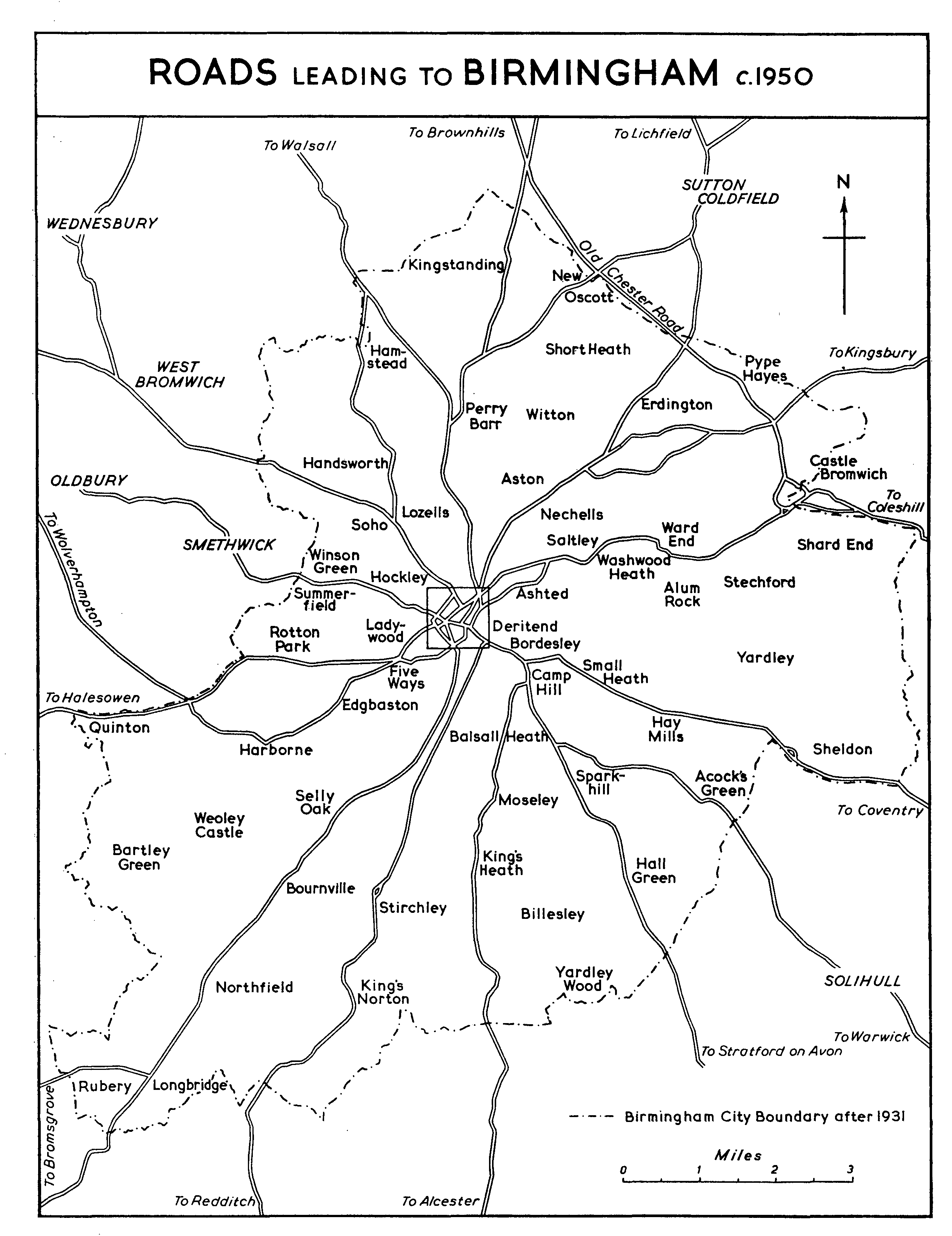
Roads leading to Birmingham c. 1950
For the area within the centre square see street plan on p. 11.
The road from Birmingham through Castle Bromwich to Coleshill was under indictment at Quarter Sessions in 1651 and 1662. (fn. 108) The watery character of the country on this side of Birmingham evidently made travelling difficult. Hutton wrote in 1781 that at Saltley 'every flood annoys the traveller', and that the river crossing at Coleshill Hall was dangerous until 1779. (fn. 109) The road to Castle Bromwich was turnpiked in 1759 as part of the Boughton, Chester, and Stonebridge Turnpike Trust; (fn. 110) in 1823 this road, together with the section of the Chester road from Stonall (Staffs.) to Stone Bridge, was placed under a separate trust, which expired in 1877. (fn. 111) In 1840 the roads of this trust were said to be in a good state of repair, having been recently improved. (fn. 112) The road between Castle Bromwich and Coleshill was apparently never turnpiked, but from Coleshill there were turnpiked roads to Atherstone, Nuneaton, and Hinckley (Leics.). (fn. 113) A road from Birmingham through Kingsbury to Atherstone was mentioned in 1648. (fn. 114) On the road to Lichfield the Hockley Brook, one mile out of Birmingham, had no bridge until 1792, (fn. 115) and the road was not turnpiked until 1807. The trust then established was responsible for the road as far as Watford Gap, on the boundary of Warwickshire and Staffordshire, where it joined the Lichfield Turnpike. There was also a branch from Sutton Coldfield to Bassett's Pole where it joined the Tamworth Turnpike, and in 1826 a branch from Gravelly Hill to Kingsbury was placed under the same trust. (fn. 116) All the trust's roads were in a poor condition in 1840, though no part of them was under indictment, and the road to Lichfield was said to have been adversely affected both by the competition of the railways and by the abolition of statute labour. It was said that on the Kingsbury branch, before abolition, statute labour could hardly ever be obtained. (fn. 117) The Kingsbury branch was disturnpiked in 1871, and the Watford Gap road, together with the Bassett's Pole branch, in 1872. (fn. 118)
The 17th-century route from London to Chester and the north-west passed several miles to the east of Birmingham. (fn. 119) The expansion of Birmingham's commerce was accompanied by the development of an alternative and, later, more important trunk route through Birmingham from London to Liverpool and North Wales. During the 16th century a route branching off the Chester road at Meriden and going through Birmingham to Wolverhampton and Shrewsbury became established, (fn. 120) and in the late 17th century the main roads from London to Shrewsbury and Ludlow diverged at Birmingham. (fn. 121) For the next hundred years, however, the normal route from London to Birmingham was the slightly circuitous one by Oxford and Stratford-on-Avon. It was by this route that the London-Shrewsbury mail travelled from 1784 (fn. 122) and that William Hutton went to London and back in the same year, (fn. 123) although a coach from London to Coventry, Birmingham, and Lichfield was travelling in 1739, (fn. 124) and a stage-coach going by Coventry, Castle Bromwich, Birmingham, Walsall, and Wolverhampton was in operation in 1780. (fn. 125) From 1808 the Holyhead mail travelled by the Oxford-Birmingham-Shrewsbury route, and from 1812 Birmingham had its own direct mail to London. From 1817 the part of the Holyhead route between London and Birmingham was the more direct one through Coventry, (fn. 126) and by 1819 this was also part of the main London-Liverpool route. (fn. 127)
The condition of the road between London and Birmingham in the 18th century and the early 19th century seems usually to have been bad. Carriers operating between Birmingham and London increased their charges in 1763 on the grounds that the deterioration of the road had increased their costs, (fn. 128) and in 1765 the cost of road transport on the London-Birmingham route was about 10s. a ton for ten miles. (fn. 129) The Royal Mail between London and Birmingham took 15½ hours in 1811, compared with about 11 hours in 1837. (fn. 130) In 1819 the London- Birmingham road was said to give great occasion for complaint: between London and Birmingham twelve horses were required to perform the same number of miles as eight would do between Birmingham and Holyhead. (fn. 131) During the next ten years considerable improvements were made: greater speeds were attained, and the making of a new stretch of road just outside Birmingham, considered essential in 1820, was abandoned as unnecessary five years later. (fn. 132)
In 1659 a coach was advertised as reaching Birmingham from London in about four days. (fn. 133) In 1679 Sir William Dugdale travelled as far as Banbury in a Birmingham coach. (fn. 134) It was announced in 1702 that the 'Wolverhampton and Birmingham Flying Stage Coach' would make the journey once a week in three days, but this venture seems to have been short-lived. In 1731 a weekly coach and a weekly wagon began to run between London and Birmingham, the time for the coach being 2½ days; (fn. 135) in 1747 a coach taking two days was advertised, (fn. 136) and in 1758 an 'improved Birmingham coach' with 'friction annihilated' was announced. (fn. 137) By 1777 there were 52 coaches, each carrying between three and six people, leaving Birmingham for London each week, compared with sixteen to Bristol, four to Sheffield, and four to Coventry. (fn. 138) When Hutton went to London in 1784 the journey took 19 hours; he described it as a 'trite journey', travelled by Birmingham tradesmen every day in the year, and Hutton found when he wished to return that even in snowy December weather all the places were booked two days in advance. (fn. 139) During the 1820s the time for the journey was greatly reduced: the shortest scheduled time was just over eleven hours, in 1836, and the record time was seven and a half hours. (fn. 140) By this date, however, the threat of the railways was already overshadowing the achievements on the roads, and the last new coach was put on the London-Birmingham route in 1837. (fn. 141)
The revival and rapid growth of road transport in the 20th century had, up to 1939, given rise to only one major development in the roads in the neighbourhood of Birmingham. This was the building of the new Birmingham-Wolverhampton road, opened by the Prince of Wales in 1927. (fn. 142) Some of the road developments designed primarily to facilitate the internal communications of Birmingham have had a considerable effect on the communications between Birmingham and its neighbours. An early example of this was the laying out of Great Lister Street in 1829, which opened a direct road from the centre of Birmingham to Castle Bromwich. (fn. 143)
During the later Middle Ages the maintenance of roads and bridges in and around Birmingham was to some extent the responsibility of the Guild of the Holy Cross (founded 1392). (fn. 144) By the 16th century the guild may have been neglecting this responsibility, for under the terms of deeds of 1526 and 1540 property left by William Lench was to be applied to the repair of roads and bridges in and near Birmingham. This charity, known as Lench's Trust, was augmented by several other benefactions. (fn. 145) From 1824 to 1828, out of an average annual rental of £656 10s., £227 was expended on the repair of streets. (fn. 146) The original terms of the trust seem to have been intended to cover the maintenance of roads leading between Birmingham and other towns, but it appears that by the late 18th century only those roads within the built-up area of the town benefited from the charity. (fn. 147)
Bridges
From an early date the crossing of the Rea at Deritend was an important link in the communications of the Birmingham area. (fn. 148) Leland mentioned Deritend Bridge: in 1536 he went through the ford beside the bridge. (fn. 149) It has been argued from this that the bridge at the time was only a footbridge, (fn. 150) but this was not necessarily so, for a hundred years later the bridge was kept closed whenever the ford provided a practicable way across. (fn. 151) There were in fact two bridges, for just above Deritend the Rea divided into two streams which joined again below the bridge. (fn. 152) There were still these two separate bridges in 1675, when it was uncertain who should repair the stretch of road between them. (fn. 153) In 1547 the Guild of the Holy Cross was said to maintain two great stone bridges, (fn. 154) presumably the bridges at Deritend. (fn. 155) Seven years earlier the charity already referred to, known as Lench's Trust, had been assigned the task of maintaining bridges in and around Birmingham. (fn. 156) The responsibility of Lench's Trust may not have extended to the two bridges maintained by the guild; and although the overlapping of the proposed objects of Lench's Trust with the avowed activities of the guild suggests that Lench's trustees were dissatisfied with the efforts of the guild, (fn. 157) the connexion between Lench's Trust and Deritend Bridge was tenuous. In 1625 the bridge was in a bad condition, and the inhabitants of Birmingham were unwilling to repair it; the justices disclaimed responsibility, and the inhabitants brought an action to have the bridge declared a county bridge. (fn. 158) Meanwhile, in 1626, it was decreed that the bridge should be repaired out of the revenue of Lench's Trust. (fn. 159) In 1642 judgment was given against the inhabitants of Birmingham, but ten years later, when the bridge had apparently fallen down from neglect, it was decided that it should be repaired by the county. (fn. 160) In 1654 it was ordered in Quarter Sessions that Lench's trustees should keep the bridge chained up except when the ford was impassable so that the recent repairs to the bridge should last longer. (fn. 161) A similar order was made in 1687, when the surveyors of the highways were made responsible for chaining up the bridge and keeping the ford in good condition. (fn. 162) Several times in the later part of the century the bridge was said to be in bad condition, and responsibility for its repair was accepted by the county. (fn. 163) A view of 1732 shows the bridge, presumably that built between 1652 and 1654, with four segmental arches and cutwater piers on each side forming recesses in the parapets; a few yards downstream there was a wooden footbridge. The view does not depict any bridge over the northern arm of the Rea, (fn. 164) which appears from a contemporary map to have been dammed up or at least greatly diminished. (fn. 165) The bridge was replaced in 1750 by one of five arches, which was said to be too narrow and too steep in the ascent. (fn. 166) This bridge was in turn replaced in 1789 by one 'more useful but less handsome', (fn. 167) built under an Act of 1788 (fn. 168) which empowered trustees to widen the approaches by removing buildings, to take tolls for four years, and thereafter to levy a rate. The tolls did not produce as much as had been expected, and the trustees encountered difficulties in levying the rate. (fn. 169) A new Act was obtained in 1813 (fn. 170) and yet another in 1822. (fn. 171) Under the more favourable terms of the last Act the trustees were able to fulfil their obligations, the bridge was rebuilt with greater width and more open approaches, (fn. 172) and in 1828, 'the whole of the objects having been accomplished', the toll-gates were removed. (fn. 173) In the late 19th and early 20th centuries the carrying out of drainage and highway schemes (fn. 174) has so altered Deritend Bridge that the river, which runs along a neat, bricked channel, cannot be seen from the main road, in which a slight rise and fall is all that indicates the crossing.
Of the other older bridges crossing the Rea, Duddeston Bridge was mentioned in the mid-15th century. (fn. 175) It was apparently not a county bridge in the 17th century. (fn. 176) It is shown on two maps of 1738 and 1760. Saltley Bridge is also marked on the same maps. (fn. 177) Over the River Cole, the New Bridge on the Yardley Green road was named in the 15th century, (fn. 178) and both this bridge and Stechford Bridge are shown on a map of 1759. (fn. 179) A bridge was built to carry the Stratford road over the Cole in 1715; a new bridge was opened in 1913. (fn. 180)
The River Tame is crossed at Hamstead by Hamstead Bridge. A bridge there was mentioned in 1688, but it was further upstream and nearer Hamstead colliery than the present bridge. A new bridge was built on the present site in 1809 or soon after. (fn. 181) Perry Bridge, about two miles downstream, was mentioned in a deed of 1612. (fn. 182) The present structure is probably that which was ordered to be built at Quarter Sessions in 1709 to replace a wooden horse-bridge. (fn. 183) Where Witton Bridge now is there was a ford called 'le Foulford' c. 1460, (fn. 184) and near Witton a part of the river was known as 'Wolfatbrugge' in 1358. (fn. 185) A map of 1758 shows Witton Bridge as a footbridge or horse-bridge with a ford a little to the south of it. (fn. 186) Salford Bridge, mentioned in 1290, (fn. 187) was described in 1536 as being of four arches of stone. (fn. 188) It was repairable by Aston parish in the early 17th century, but during the Civil War it was destroyed by the parliamentary troops and was thereafter chargeable to the county. (fn. 189) In 1687 the surveyors of the parish highways were ordered to keep the ford by the bridge in good condition and to chain up the bridge when the ford was passable. (fn. 190) A map of 1738 shows Salford Bridge crossing the river at an island. (fn. 191) Bromford Bridge, mentioned in 1317-18 and c. 1460, (fn. 192) is shown on a map of 1759. (fn. 193) It was repaired in 1821 when £12 was paid out of Knight's charity, which had been founded in 1736 largely for the purpose of maintaining roads and bridges in and near Castle Bromwich; (fn. 194) in the early 19th century, however, only two payments were made for this purpose apart from 5s. paid annually to the surveyors of highways. (fn. 195) Castle Bromwich Bridge, the last before the Tame leaves Birmingham, is shown on a map of 1798. (fn. 196) It was rebuilt by Birmingham Corporation in 1934. (fn. 197) In 1669 the inhabitants of Erdington were presented for not repairing three horse-bridges called 'Erdington bridges' leading between Erdington and Castle Bromwich; (fn. 198) it is possible that these included Bromford Bridge or Castle Bromwich Bridge.
By a deed of 1612 Nicholas Hodgetts of Handsworth granted property for the maintenance of bridges in Handsworth; this endowment is known as the Handsworth Bridge Trust. In 1823 the trust maintained five carriage bridges and three footbridges; one of the carriage bridges, that over the Hockley Brook at the bottom of Soho Hill, was repaired jointly with Birmingham, and another was repaired jointly with Great Barr. Two bridges had been transferred from the parish to the county at the beginning of the 19th century, and, as the value of the trust's property increased, the excess of income over the expenditure required on the bridges was spent on educational purposes. (fn. 199) A Scheme of 1859 reduced the trust's responsibility for bridges in the parish, and in recent times only a small proportion of the trust's income has been spent on bridges. (fn. 200)
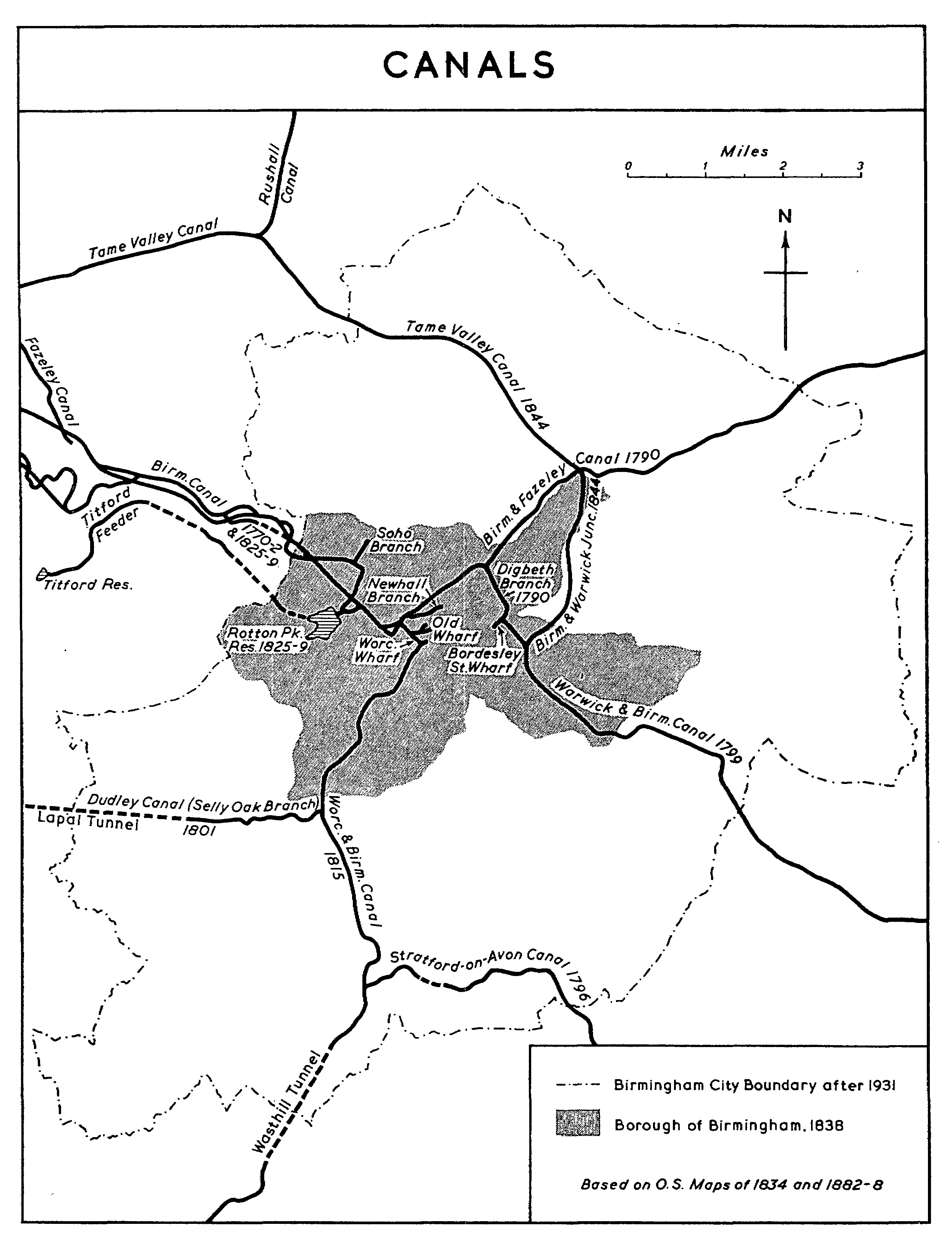
Canals
The importance in Birmingham's development of its canal system is matched by the enormous physical difficulties which were overcome in constructing it. The steep edges of the Birmingham plateau made necessary long flights of locks, and the uplands of the region, especially the SedgleyRowley ridge and the sharp slopes of the upper Stour valley, were considerable obstacles. Almost entirely as a result of the problems set by the terrain the Worcester and Birmingham Canal took 24 years to build, and in the course of that time the shares fell from £140 to nothing. (fn. 201) The Stourbridge Canal required 20 locks to rise from Stourton to Pensnett Chase, and then wound round Brierley Hill to Black Delph and climbed through a further nine locks to the level of the Dudley Canal. (fn. 202) Moreover, natural water supplies were insufficient to keep the canals full enough to be navigable, and special arrangements had to be made. (fn. 203) The Birmingham Canal was entirely supplied by artificial means; (fn. 204) and in the early 20th century the chief criticism of the Birmingham Canal was that the water was not kept at a sufficiently high level to allow the narrow boats to take their full loads. (fn. 205) The canals of the district came to depend for most of their water on supplies pumped from colliery workings. (fn. 206) 'Nothing more fully shows the enterprising genius of the inhabitants of Birmingham', it was said in 1803, 'than the number of canals cut from that town in every direction.' (fn. 207) The Birmingham canal network performed a double function: it provided a cheap means of transport for coal, limestone, and iron within the district - a function which it still performs to some extent - and it formed a connexion between the manufacturing district and the chief national water-routes. (fn. 208)
Until the building of the canals Birmingham's inland position and its distance from any navigable river placed it at a disadvantage compared with most other comparable towns. The nearest large rivers were the Trent, usually navigable only as far as Nottingham, (fn. 209) and the Severn. In 1695 and 1720 Birmingham inhabitants joined in unsuccessful attempts to have the Derwent made navigable between Derby and its confluence with the Trent. Following an Act passed in 1698 the Trent (fn. 210) was made navigable as far as Burton, but merchants, traders, and other inhabitants of Birmingham complained in 1714 that shipping on it was being monopolized. (fn. 211) The first canal of the district was the Birmingham Canal, for which an Act was obtained in 1768. (fn. 212) This canal has remained the most important to Birmingham's commerce and industry, and from the company of its proprietors originated the Company of the Proprietors of the Birmingham Canal Navigations, which from the mid-19th century controlled the network of waterways radiating outwards to the east, north, and west of the town and forming the nucleus of the midland canal system. (fn. 213) The prosperity and usefulness of the Birmingham Canal stimulated other companies to obtain Acts for further canals - the Dudley Canal (1776), (fn. 214) the Birmingham and Fazeley Canal (1783), (fn. 215) the Worcester and Birmingham Canal (1791), (fn. 216) the Warwick and Birmingham Canal (1793), (fn. 217) the Stratford-on-Avon Canal (1793), (fn. 218) and the Birmingham and Warwick Junction Canal (1840). (fn. 219) In addition to these, all of which pass through the area of the modern city of Birmingham, a number of other canals can be regarded as forming part of the Birmingham canal network but are not described in any detail at this point. These are the Staffordshire and Worcestershire Canal (Act obtained 1766), (fn. 220) the Coventry Canal (1768), (fn. 221) the Stourbridge Canal (1776), (fn. 222) the Wyrley and Essington Canal (1792), (fn. 223) and the Birmingham and Liverpool Junction Canal (1826). (fn. 224)
In 1767, a year after the authorization of the Staffordshire and Worcestershire Canal, which was to link the Severn with the Trent and Mersey Canal, a subscription was opened for a canal from Birmingham through Wolverhampton to Aldersley (Staffs.) on the Staffordshire and Worcestershire, and an Act was obtained the following year. (fn. 225) The undertaking possessed two attractions: the canal would enable coal to be brought more cheaply to Birmingham from the south Staffordshire coalfields, and it would link Birmingham with Bristol, Liverpool, and Hull. The canal was surveyed by James Brindley, and in 1770 the first cargo was carried. (fn. 226) Coal from Wednesbury was sold in Birmingham at 7s. a ton, little more than half the price before the canal was built. (fn. 227) In 1772 the junction at Aldersley was made with the Staffordshire and Worcestershire, (fn. 228) which was itself completed in the same year. (fn. 229) By 1772 the Birmingham Canal had cost £100,000, and between then and 1795 improvements cost a further £50,000. (fn. 230) As originally built, the canal followed a meandering course, 22 miles from the Birmingham wharf at Broad Street to Aldersley, and crossed the summit at Smethwick by a series of locks. (fn. 231) In 1824 Thomas Telford undertook to improve the canal, which was by then inadequate for its requirements. He found the canal 'little better than a crooked ditch', with almost no towing path and serious traffic jams. Telford reduced the length of the main canal to 14 miles by cutting off numerous bends, including two within modern Birmingham, which remained to serve as branches; he also widened the canal through its whole length, drove a 70-ft. cutting through the Smethwick summit, and built the Rotton Park reservoir for the canal's water-supply. Telford was said at Birmingham to deserve a public reward for introducing good manners among the boatmen - a measure of the value of his improvements. (fn. 232) There was a further major improvement when the tunnel through Coseley Hill was built in 1837. (fn. 233)
Meanwhile, canal-building was improving Birmingham's communications in other directions. In 1783 an Act was obtained for building the Birmingham and Fazeley Canal to join the Birmingham Canal with the Coventry Canal. (fn. 234) The Birmingham and Fazeley Canal, which included a branch to Digbeth, was completed in 1790, when the aqueduct across the Tame at Salford Bridge was finished. (fn. 235) This provided a much shorter route to Hull than that through Aldersley, and ultimately afforded a connexion with London via the Coventry, Oxford, and Grand Junction Canals. Goods from Liverpool and Manchester were brought to Birmingham chiefly by way of Fazeley, and grain was brought to Birmingham from Oxfordshire. (fn. 236) Until the building of the Grand Junction Canal goods from Birmingham bound for London were taken as far as Oxford by canal and thence by road. (fn. 237)
A new route between Birmingham and the Severn was opened when the Dudley Canal Company built a new cut, authorized in 1785, from Black Delph, north-east of Stourbridge, through the Dudley tunnel to Tipton Green (Staffs.) on the Birmingham Canal. (fn. 238) The Dudley Canal connected with the Stourbridge Canal (both were authorized in 1776) which in turn made a junction with the Staffordshire and Worcestershire at Stourton. Before this cut had been completed, (fn. 239) the Worcester and Birmingham Canal was authorized by an Act of 1791; (fn. 240) it was to link Birmingham even more closely to the Severn and by-pass the stretch of river, where traffic was held up in dry weather, between Stourport and Worcester. (fn. 241) The opposition to this new canal, first by the Dudley Canal Company and then by the Staffordshire and Worcestershire, was so considerable that a compromise was reached in the Act to the effect that there was to be no junction at Birmingham between the Worcester and Birmingham Canal and the Birmingham Canal. (fn. 242) In 1793, however, the Dudley Canal Company began a new cut, involving the tunnel of over 2 miles through the ridge at Lapal, to link its own canal with the Worcester and Birmingham at Selly Oak. This was completed in 1801. (fn. 243) The full results of these developments were not seen for a number of years; the Worcester and Birmingham Canal was completed, after many difficulties, only in 1815. (fn. 244) In the same year the enactment prohibiting a junction between the Birmingham Canal and the Worcester and Birmingham Canal was reversed. (fn. 245)
Acts for the Warwick and Birmingham Canal and the Stratford-on-Avon Canal were obtained in 1793. The Warwick and Birmingham Canal joined the Birmingham and Fazeley Canal at Digbeth and was completed in 1799, providing a more direct route for waterborne traffic from Birmingham to London, especially after the opening of the Grand Junction Canal in 1805. The Stratford-on-Avon Canal was completed as far as Hockley Heath in 1796, joining the Worcester and Birmingham at King's Norton. (fn. 246) With the completion of the Worcester and Birmingham the skeleton of the Birmingham canal system was largely finished. Of later developments the most important was the opening of the Birmingham and Liverpool Junction Canal, authorized in 1826, (fn. 247) which shortened the distance by water to the Mersey. Other developments included the opening of the Birmingham and Warwick Junction Canal (from the Warwick and Birmingham at Bordesley to the Birmingham and Fazeley at Salford Bridge) in 1844, (fn. 248) of the Tame Valley branch of the Birmingham Canal under Acts of 1839 and 1840, (fn. 249) and of the Netherton tunnel in 1855 to provide a much shorter route from Birmingham to the Stour valley. (fn. 250) By the mid-19th century the Birmingham Canal Navigations had become the hub of the national canal system. (fn. 251)
By 1846 the control of the canals around the north, west, and east of Birmingham had become amalgamated under a single company. The Company of the Proprietors of the Birmingham Canal Navigations (the full title of the owners of the original Birmingham Canal) was reorganized in 1784 under the same name when the Birmingham and Fazeley Canal Company was merged with it. In 1840 this company took over the Wyrley and Essington Canal Navigations, a network of canals in south Staffordshire, stretching between Wolverhampton and Lichfield, which originated in 1792 and was used principally for the carriage of coals. Finally, in 1846, the Dudley Canal Company was merged with the Birmingham Canal Navigations. (fn. 252)
From an early date the Birmingham Canal Navigations were so well used that they became overcrowded. (fn. 253) The prosperity of the company in the first fifty years of its existence is represented by the rise in the value of its shares. The original shares were computed to have cost £140 each; by 1782 they were worth £370 and by 1792 £1,110. (fn. 254) They suffered a temporary fall in value as a result of the opening of the Dudley Canal's extension to Selly Oak, (fn. 255) but in 1813 half shares were selling for up to £585. By 1824 the shares had been divided into eighths and were selling for £360 each. (fn. 256) Thereafter the threatened competition of the railways seems to have caused a steady decline in value. The eighthshares were down to £284 by 1830, to £200 in 1840, and to £158 in 1844. (fn. 257)
In 1846, shortly before the amalgamation of the Dudley Canal Company with the Birmingham Canal Navigations, an agreement was reached between the London and Birmingham Railway Company and the Birmingham Canal Navigations. The canal company was to contribute a quarter of the cost of constructing the Birmingham, Wolverhampton and Stour Valley Railway, (fn. 258) which would run alongside the canal, while the railway company was to guarantee the canal company's dividend. Representation on the canal company's board was to be divided equally between the canal company and the railway company, the representatives of the canal company having the casting vote as long as the guarantee was not needed, and the representatives of the railway company having it in the years for which the guarantee was needed. With the exception of the year 1868 the guarantee was not needed until 1874, when the canal came under continuous railway control. Between 1876 and 1905 the annual average of the deficiencies in the canal's affairs made up by the railway company was £22,500. (fn. 259)
The Warwick and Birmingham Canal and the Birmingham and Warwick Junction Canal remained independent until they became part of the Grand Union in 1929. (fn. 260) The Stratford-on-Avon Canal was acquired by the Oxford, Worcester and Wolverhampton (later the Great Western) Railway Company in 1846, and entered a gradual decline; by 1939 it was no longer navigable for commercial purposes. (fn. 261) The Worcester and Birmingham Canal, which had an unusually expensive line to maintain, suffered heavily from railway competition and passed into the hands of a receiver in 1863. It was acquired by the Gloucester and Berkeley Canal Company (later the Sharpness Docks and Gloucester and Birmingham Navigation Company) in 1874, in whose hands it continued to be an expensive liability. (fn. 262)
The tonnage carried on the Birmingham Canal Navigations rose steadily from 4½ million in 1848 to 8½ million in 1898, and thereafter fell to 7½ million in 1905. These totals were far higher than those for any other canal company in the same period, (fn. 263) but more than four-fifths of the tonnage appears to have been loaded and discharged on the canal company's own waterways. (fn. 264) Through traffic was discouraged by the company's refusal to make adequate concessions in tolls on cargoes which originated from and were destined for canals outside the company's network. (fn. 265) The Warwick and Birmingham Canal, which took most of the waterborne traffic between Birmingham and London, carried 226,000 tons in 1848 and 354,000 tons in 1898. (fn. 266) Between 1895 and 1905 through tonnage between Birmingham on the one hand and Brentford and Paddington on the other fell from 102,000 to 92,000. (fn. 267)
In the early 20th century the Birmingham canals comprised 3.1 per cent. of the total mileage of navigable waterways in actual operation in the United Kingdom, and carried 19.1 per cent. of the total tonnage. The average distance travelled by each ton, however, was very short; on the Warwick and Birmingham Canal it was 10½ miles. Most of the tonnage consisted of raw materials and goods exchanged between collecting basins belonging to the railways and works situated on the canals, or of coal from the collieries of the district brought to the works and depots within the district. About 15 per cent. of the tonnage was being carried to and from railway basins. (fn. 268) On the Birmingham Canal Navigations there were about 550 private basins and branches, and along the banks iron-works and other factories formed 'an almost continuous line for many miles between Birmingham, Wolverhampton, and other places'. (fn. 269) Great expenditure was involved in maintaining the canals. On the Birmingham Canal Navigations 31½ million gallons of water a day were pumped from a low level to a higher level, and throughout the district subsidence caused trouble. (fn. 270) Neither the Dudley tunnel nor the Lapal tunnel had a towpath; (fn. 271) the process of 'legging' through the latter took about 4 hours, and it had ceased to be used for traffic by 1926. (fn. 272) Boats were held up by not being able to pass at locks and bridges, and there were allegations that the canal companies had neglected to dredge, so that the boats were not able to take their full loads. (fn. 273)
CANALS
In the 20th century the Birmingham canals declined in importance less than most others. The reports of the Royal Commission on Canals and Inland Waterways (the Shuttleworth Commission, 1906-11) stimulated controversy about the economy and usefulness of canals, and schemes for reviving canal traffic and reorganizing the canals, usually on the lines recommended by the Royal Commission, continued to be discussed until the end of the thirties. The only major development, however, was the formation of the Grand Union in 1929, which incorporated the Warwick and Birmingham Canal and the Birmingham and Warwick Junction Canal; about £1 million was spent on improving the canals between London and Birmingham. (fn. 274) The Birmingham canal network continued to be used largely for collection and delivery between factories and railways, (fn. 275) and despite a report of overcrowding on the old Birmingham Canal in 1912 (fn. 276) the traffic there was contracting. The Soho branch was abandoned in 1909, (fn. 277) and the Old Wharf at Paradise Street was closed in 1926. (fn. 278) The Birmingham canals have remained, however, comparatively busy and in good condition. (fn. 279)
The first step towards public ownership of the canals came during the Second World War, when the West Midland region of canals, based on the Birmingham Canal Navigations, was under the control of headquarters at Birmingham. (fn. 280) Under the Transport Act of 1947 the undertakings of the Birmingham Canal Navigations, the Grand Union, the Sharpness Docks and Gloucester and Birmingham Navigation Company, and the Great Western Railway, which by then owned between them all the canals passing through Birmingham, were vested in the British Transport Commission. (fn. 281)
Of the canal works within the boundary of Birmingham in 1957 the Birmingham Canal, the Selly Oak branch of the Dudley Canal, the Worcester and Birmingham Canal, and the Stratford-onAvon Canal are on the 'Birmingham level' (453 ft.). Other works described below are on the 'Walsall level' (408 ft.).
The Birmingham Canal enters Birmingham at Merry Hill, and divides near King Edward's Road to form two termini near the centre of Birmingham, the Broad Street basin and the Newhall Street basin. From the Broad Street basin the Worcester Bar junction forms a connexion with the Worcester and Birmingham. The Old Wharf at Broad Street, which extended to Paradise Street where the Navigation Office (fn. 282) used to stand, was closed in 1926, and a municipal car park was laid out on the site. From the Newhall Street branch there is a junction with the Birmingham and Fazeley Canal. The straightening of the line of the canal in the 1820s provided two loops to serve as branches. The larger of these, the Soho branch, was abandoned in 1909; the other connects the main line of the canal with the Rotton Park reservoir. Excluding the loops, the length of the canal in Birmingham is about 2 miles.
The Selly Oak branch of the Dudley Canal enters Birmingham by the Lapal tunnel (about 2 miles in total length), emerges at California, and joins the Worcester and Birmingham at Selly Oak. Its length within Birmingham is about 3 miles.
The Worcester and Birmingham Canal enters Birmingham through the Wasthill (or Westhill) tunnel, just over 1½ mile long in all, emerging near King's Norton. It is joined at Lifford by the Stratford-on-Avon Canal and at Selly Oak by the Dudley Canal. It passes under Church Road, Edgbaston, through a tunnel of about 100 yards, and joins the Birmingham Canal near the Old Wharf by Broad Street. The length of the canal within Birmingham is about 7 miles.
The Stratford-on-Avon Canal enters Birmingham at Yardley Wood and extends thence about 3 miles to its junction with the Worcester and Birmingham Canal, where there is an unusual guillotine or portcullis stop-lock. Near Brandwood End there is a tunnel about 300 yards long.
The Warwick and Birmingham Canal enters Birmingham at Acock's Green, descends through six locks at Bordesley to the junction with the Birmingham and Warwick Junction Canal, and then proceeds to the Birmingham bar and the junction with the Digbeth branch, both near Fazeley Street. The length of the canal within Birmingham is about 4½ miles.
The Birmingham and Warwick Junction Canal, about 3 miles in length, leaves the junction with the Warwick and Birmingham at Bordesley, and descends by five locks near Lower Dartmouth Street and one lock by Salford Bridge, where it joins the Birmingham and Fazeley.
The Birmingham and Fazeley Canal enters Birmingham at Tyburn. After its junctions with the Birmingham and Warwick Junction Canal at Salford Bridge and with the Tame Valley branch at Salford Junction it ascends through eleven locks at Aston to a junction with the Digbeth branch, and then through the thirteen Farmers' Bridge locks to its junction with the Newhall branch of the Birmingham Canal by Kingston Row. The length of this canal within Birmingham is about 6 miles.
The Digbeth branch, which is about 1 mile in length, extends between its junction with the Birmingham and Fazeley near Aston Road and the Bordesley Street Wharves, descending by six locks at Ashted, and making a junction with the Warwick and Birmingham shortly before its Bordesley Street terminus.
The Tame Valley branch enters Birmingham at Hamstead and descends through the thirteen Perry Barr locks (arranged in three flights) to its junction with the Birmingham and Fazeley. Its length in Birmingham is about 4 miles.
Railways
The possibility that railways might provide Birmingham with better communications than either roads or canals was given public expression in 1824. In that year an unsuccessful attempt was made to obtain an Act for a railway between Birmingham and Birkenhead. (fn. 283) The plan seems to have originated in Birmingham, and in 1825 a meeting in Birmingham launched a similar project for a railway to London. (fn. 284) A line north-west from Birmingham became a more practical proposition in 1829 when Parliament authorized a line from Warrington to join the railway between Liverpool and Manchester at Newton-le-Willows, (fn. 285) and in 1833 the Grand Junction Railway Company obtained an Act for a railway from Birmingham to Warrington. (fn. 286) In the same year, following an unsuccessful attempt in 1832, a railway from Birmingham to London was authorized. (fn. 287) Trains first ran between Birmingham and Liverpool in 1837, and between Birmingham and London in 1838. (fn. 288) At Birmingham, Curzon Street station was the terminus for both lines (fn. 289) (although Vauxhall station was temporarily used as the terminus of the Grand Junction Railway), (fn. 290) and thus the railways provided a route from London to Liverpool and Manchester; but the demand for these railways was created mainly by the need of Birmingham manufacturers for faster and cheaper connexions with the markets for their goods. (fn. 291) The greater part of the early business of these lines was passenger transport: in 1839 the Grand Junction Railway took gross receipts of £281,125 from passengers and £66,457 from goods, (fn. 292) and the improvement in comfort and speed (under 5 hours from Birmingham to London by railway in 1840, (fn. 293) compared with about 11 hours by road) (fn. 294) was obvious. At the same time the competition of the railways forced the canal carriers to lower their prices; (fn. 295) canal-borne merchandise took at least three days to reach London, (fn. 296) and the proportion carried by the railway rapidly increased. (fn. 297)
The development of railways aroused considerable opposition at this period; hostility to the London and Birmingham Railway was especially marked. (fn. 298) The fares charged and the virtual monopoly (fn. 299) exercised by the company in the carriage of goods and passengers provided a rallying point for the opponents of railways in general. The original authorized capital for the company was £2½ million, but as a result of the difficulty of the route (fn. 300) and the need to provide more expensive station facilities than were originally planned the paid-up capital amounted to nearly £5 million by 1839. (fn. 301) Nevertheless the success of the enterprise was undeniable. In 1841 eleven trains ran each day between London and Birmingham, the first-class fare being £1 10s., the third-class £1. (fn. 302) The receipts from passenger traffic were £557,000, and from goods £137,000, each of these figures being higher than those for any other company. (fn. 303) At this period the London and Birmingham Railway was 'looked upon as the most enlightened of the companies in its methods of operation', (fn. 304) and between November 1839 and March 1840 only 27 trains arrived at Birmingham late, 754 being on time. (fn. 305)
While Birmingham's first two railways, the Grand Junction and the London and Birmingham, providing routes north-west and south-east, were along the most needed routes, there was incentive enough for railway-building in other directions. In 1839 the Birmingham and Derby Junction Railway provided, by means of a branch from Whitacre to Hampton on the London and Birmingham, (fn. 306) a railway route to the north-east, and the last stretch of the main line, between the Birmingham terminus at Lawley Street and Whitacre Junction, was opened in 1842. (fn. 307) This railway connected Birmingham to the North Midland Railway, which gave access to Leeds and Hull. South-west the Birmingham and Gloucester Railway, authorized in 1836 (fn. 308) and providing a link with the Great Western, had to cover difficult country calling for the use of special engines. By 1840 trains were running from Gloucester to a temporary passenger terminus at Camp Hill, and next year a junction (the 'Gloucester Junction') was made with the London and Birmingham line, enabling the trains to enter Curzon Street station. (fn. 309) Under an Act of 1845 (fn. 310) a further junction was made between the Gloucester line and the Derby line, by then part of the Midland company, with which the Birmingham and Gloucester was amalgamated in the following year. (fn. 311)
Three other railways to Birmingham were authorized in 1846, at the height of the 'railway mania'. The Birmingham, Wolverhampton and Dudley Railway (fn. 312) and the Birmingham and Oxford Junction Railway (fn. 313) formed a line through the middle of Birmingham which connected at Oxford with the Great Western system, with which these two companies were amalgamated. They were opened in 1854 and 1852 respectively. (fn. 314) The Birmingham, Wolverhampton and Stour Valley Railway, (fn. 315) which was built as a continuation of the Grand Junction and the London and Birmingham lines' extension into the middle of Birmingham, was also opened in 1852. (fn. 316) In addition to these, a singletrack branch between Northfield on the Gloucester line and Halesowen was also authorized in 1846, (fn. 317) though it was not opened until 1884. (fn. 318)
Meanwhile the more important railway companies had been competing to extend their sphere of influence over the more recently constructed lines. The Great Western and the Midland Counties Railway struggled with each other to gain a foothold in the growing network of railways projected around Birmingham, (fn. 319) and the Midland, formed in 1844 to include the Birmingham and Derby Junction Railway, (fn. 320) gained possession of the Birmingham and Gloucester Railway in 1846, (fn. 321) thus denying the Great Western direct entry into the midlands. The Birmingham and Oxford Junction Railway, however, provided this when in 1852, the year of its completion, it became part of the Great Western system. (fn. 322) The Great Western also finally acquired the Birmingham, Wolverhampton and Dudley Railway, which carried the line of the Birmingham and Oxford beyond the town on the north-west side, in 1852. (fn. 323) The Grand Junction and the London and Birmingham united, together with the Manchester and Birmingham Railway, (fn. 324) in 1846 to form the London and North-Western Railway, (fn. 325) and in the following year this company acquired the Birmingham, Wolverhampton and Stour Valley Railway, (fn. 326) which was still at an early stage of planning. All the later lines in the district were built under the auspices of one of these three large companies, and the merging of the Midland and the London and North-Western under the Railways Act of 1921 (fn. 327) established the pattern of railway ownership that survived until nationalization under the Transport Act of 1947. (fn. 328)
Although the intricate history of the rivalry between the railway companies is not properly part of the history of Birmingham, the competitive activities of the various companies had an effect on the provision of railway communications to and from Birmingham. The rivalry of the Birmingham and Derby Junction Railway with the Midland Counties Railway was responsible for the speed with which the former's line was built, and for the fact that the branch from Whitacre Junction to Hampton was completed before the main line from Birmingham to Whitacre Junction. (fn. 329) The projected line of the Birmingham, Wolverhampton and Dudley Railway promised a better route to Wolverhampton than that provided by the branch from the Grand Junction line, and this fact underlay the London and North-Western's acquisition of the Birmingham, Wolverhampton and Stour Valley Railway, the opening of which was delayed by intercompany rivalry. (fn. 330) The line from Birmingham to Oxford was first sponsored by the Grand Junction Railway, to break the London and Birmingham's monopoly in traffic between London and Birmingham, and, especially after the amalgamation of the Grand Junction and the London and Birmingham, by the Great Western with the aim of extending the run of broad-gauge railways. (fn. 331) An unfinished branch line (fn. 332) from Bordesley station towards Curzon Street station survives as evidence of one railway company's desire to prevent the fulfilment of a project which it had imposed on another company. (fn. 333)
The four earliest of Birmingham's railways all arrived at the town by the Rea valley, and the two terminal stations, Curzon Street and Lawley Street, were conveniently close together. The convenience was greater, however, for traffic using Birmingham merely as a railway junction than for traffic whose origin or destination was Birmingham. Horsedrawn carriages took passengers between Curzon Street and the centre of Birmingham. The distance of about a mile, combined with the inevitable change of vehicles, took a disproportionate length of time, and the location of the stations on the eastern edge of Birmingham diminished the advantages of railway communication for passengers, and particularly for goods, whose journey began north, west or south of the town's centre. As this inconvenience became apparent, and as plans for railways between Birmingham and Wolverhampton took shape, the decision was taken to build the railways through the centre of the town and to establish the main stations there. Despite the expense of acquiring land and building cuttings and tunnels, the London and North-Western decided in 1846, the year of its formation, to close Curzon Street station to passenger traffic and to build New Street station. (fn. 334) Though designed primarily for the London and Birmingham, the Grand Junction, and the Stour Valley lines, New Street station was later enlarged to allow the Midland Railway to run its trains between Derby or Leicester and Bristol through central Birmingham. The station was opened for the Stour Valley line in 1852 and for the London, Manchester and Liverpool lines in 1854; it was first used by the Midland Railway in 1854. (fn. 335) Snow Hill station was opened in 1852. (fn. 336) The effect of the building of these stations and railway lines on the shape of central Birmingham has been indicated above. (fn. 337) Apart from making easier the journeys between Birmingham and distant towns, they also made possible the development of suburban railway traffic.
The early railways from Birmingham were planned almost exclusively for long distance traffic. The number of intermediate suburban stations before the fifties was negligible. Near the centre of the town Vauxhall station and Camp Hill station, built as temporary termini, survived as intermediate stations after the extension of the lines. (fn. 338) Apart from Vauxhall, Perry Barr station was the only intermediate station within the modern city on the Grand Junction line built at the same period as the railway itself. On the London and Birmingham line Stechford station (opened 1844) was the only intermediate station built before 1860. On the Birmingham and Derby Junction Railway two intermediate stations, Bromford Forge and Castle Bromwich, were opened at the same time as the railway, but Bromford Forge was closed the next year and was reopened for race-course traffic only as Bromford Bridge station in 1896. On the Gloucester line there were, apart from Camp Hill, stations at King's Heath and Lifford opened in 1840, the year the railway was opened, one at King's Norton opened in 1849, and one at Longbridge opened in 1840 and closed in 1849. The building of the new main stations allowed those who worked in the centre of Birmingham to get there by train from such suburban stations as existed, and the new lines (the Birmingham and Oxford Junction, the Stour Valley, and the Birmingham, Wolverhampton and Dudley) which were the principal justification for the new main stations had less of the character of trunk lines than the older railways.
The possibility of suburban railway travel thus presented was realized through the building of a number of intermediate stations (fn. 339) and the opening of new suburban lines. When the Birmingham, Wolverhampton and Dudley line was opened in 1854 three stations within the modern city (Hockley, Soho and Winson Green, and Handsworth and Smethwick) were also opened. On the Stour Valley line Monument Lane station, a mile from New Street, was opened in 1854 and Winson Green station, a little further out, in 1876. On the Oxford line stations were built at Acock's Green (1852), Bordesley (1855), and Small Heath (1863). Intermediate stations were also opened on the older lines; on the Grand Junction lines at Aston (1854), Great Barr (1862), and Witton (1876); on the London and Birmingham line at Adderley Park (1860); on the Birmingham and Derby line at Saltley (1854); and on the Gloucester line at Moseley (1867), Northfield (1869), Brighton Road (1875), and Hazelwell (1903). The rapid building in the fifties of suburban stations on the through-routes was followed by the opening of railways specifically designed for a suburban population. The Sutton Coldfield Railway, an offshoot of the London and North-Western, was authorized in 1859 and opened, with stations at Gravelly Hill and Erdington, in 1862. (fn. 340) Another offshoot of the London and North-Western, the Harborne Railway, was authorized in 1866 and opened in 1874: (fn. 341) it passed through rapidly extending suburbs (fn. 342) and had four stations in little over two miles. The Birmingham West Suburban Railway was authorized in 1871 to run from a terminus at Granville Street, north of Five Ways, to a junction with the Gloucester line at King's Norton. (fn. 343) It was under the wing of the Midland and in 1873 Parliament authorized the extension of the line to New Street station (fn. 344) so that the Midland (with which the new line was incorporated in 1875) (fn. 345) might use it as part of a through-route, but it was planned and to a great extent run as a suburban line. It was opened in 1876, with five stations including the terminus at Granville Street. (fn. 346) When the line was extended in 1885 to New Street station an intermediate station at Five Ways replaced the terminus at Granville Street. Another suburban route was the London and North-Western's branch between the Grand Junction and the Stour Valley lines, which was authorized in 1883 and opened in 1886, (fn. 347) and on which stations were opened at Soho Road (1889) and Handsworth Wood (1896). This was one of two branches built by the London and North-Western to by-pass the centre of Birmingham; the other, opened in 1880, was a stretch of railway without stations between Stechford and Aston. (fn. 348) The same period saw the extension of railway works in the Saltley area, the construction of a branch from Aston to the gas-works by Great Lister Street, (fn. 349) and the opening of a line between Northfield and Halesowen, which was run jointly by the Midland and the Great Western. (fn. 350) The last suburban line to be built within the area of the modern city was the Birmingham, North Warwickshire and Stratford on-Avon Railway, and like the Birmingham West Suburban it also served as a through route, making a short cut for the Great Western between Wolverhampton and Bristol. The line was authorized in 1894, and the company promoting it was taken over by the Great Western in 1900. (fn. 351) It was opened for goods traffic in 1907 and for passenger traffic in 1908, (fn. 352) and the stations opened then included those at Hall Green and Yardley Wood. A new station had also been opened at Tyseley, where the North Warwickshire line joined the Oxford line, in 1906. The extra pressure which the opening of this line caused at Snow Hill station was relieved by the building of a new terminus at Moor Street: a temporary station was opened in 1909 and a permanent one in 1914. (fn. 353)
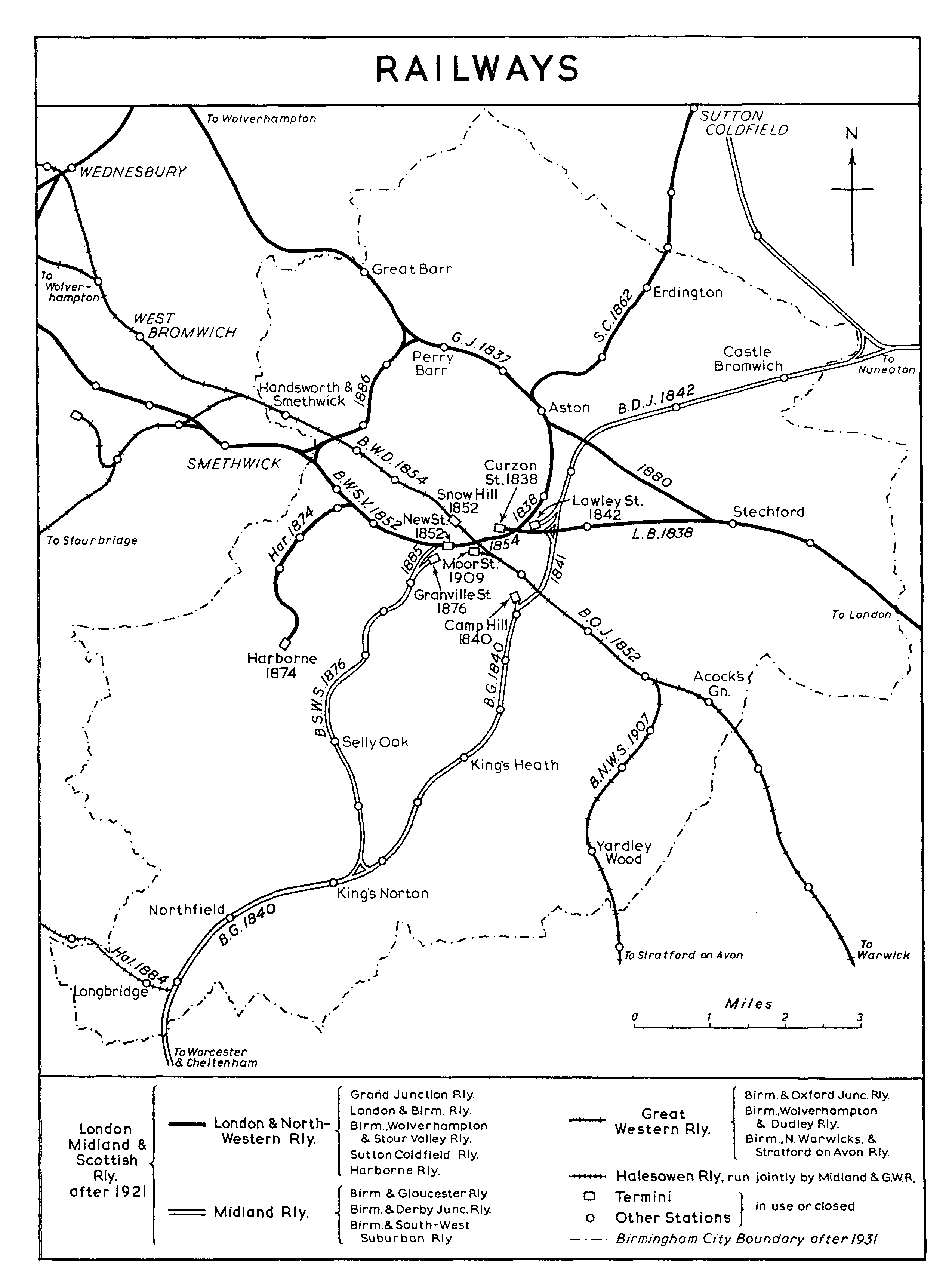
RAILWAYS
It is not possible to assess by the use of statistics the boost which the railways gave to the expansion of Birmingham, but it is fair to say that that expansion, from 1837 onwards, was dependent on the lines of communication provided by the railways. In the first place, the opening of trunk lines enabled more direct commercial contacts between Birmingham and the markets for its manufactures as well as providing the opportunity for quicker industrial turnover through the more rapid movement of goods and raw materials. As the railway network was extended, manufacturers established their factories near goods depots or built their own private branches, so that Birmingham's industries expanded, geographically, along the lines of the railways. The increasing number of work-people, prevented by their numbers from living close to their places of employment, were able to travel to and from work by suburban trains, and at the same time as the railways made the spread of suburban housing possible the location of lines and stations to a large extent determined its pattern. (fn. 354)
Since the First World War, however, Birmingham's railway system has contracted rather than expanded. A new station was opened at Spring Road on the North Warwickshire line in 1919, but since then only two new stations have been opened in Birmingham (Lea Hall, opened 1939; Longbridge, opened 1954), and no new railways have been built. The tram services of the city, suffering from some of the same limitations as the railways, did not seriously compete for passenger traffic, but the growing use of the more adaptable motor omnibuses and of bicycles and cars drew passengers away from the railways, and, from a later date, the advantages of road haulage over the railway goods services became apparent. The station at Church Road on the Birmingham West Suburban line was the first to close (in 1925) in the face of this competition, and the stations on each side of it were closed in 1930 and 1944. The Harborne Railway was not used for passenger traffic after 1934, and all the stations on the Gloucester line north of King's Norton were closed in 1940 and 1941. (fn. 355)