A History of the County of Warwick: Volume 8, the City of Coventry and Borough of Warwick. Originally published by Victoria County History, London, 1969.
This free content was digitised by double rekeying. All rights reserved.
'The City of Coventry: Communications', in A History of the County of Warwick: Volume 8, the City of Coventry and Borough of Warwick, ed. W B Stephens (London, 1969), British History Online https://www.british-history.ac.uk/vch/warks/vol8/pp34-39 [accessed 30 April 2025].
'The City of Coventry: Communications', in A History of the County of Warwick: Volume 8, the City of Coventry and Borough of Warwick. Edited by W B Stephens (London, 1969), British History Online, accessed April 30, 2025, https://www.british-history.ac.uk/vch/warks/vol8/pp34-39.
"The City of Coventry: Communications". A History of the County of Warwick: Volume 8, the City of Coventry and Borough of Warwick. Ed. W B Stephens (London, 1969), British History Online. Web. 30 April 2025. https://www.british-history.ac.uk/vch/warks/vol8/pp34-39.
In this section
COMMUNICATIONS (fn. 1)
ROADS.
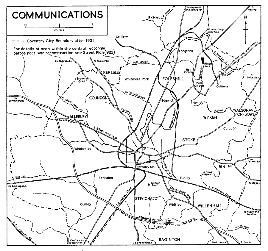
None of the roads around Coventry lies on the line of a Roman road: there was no Roman settlement on the site, and the nearest roads were the Fosse Way, six miles to the south-east, and Watling Street, nine miles to the north-west. The modern road pattern had for the most part been established by at least the 17th century, (fn. 2) and only minor changes of alignment were made during the turnpiking improvements of the 19th century. One important addition was made in the 20th century when a by-pass road was completed in 1940 (fn. 3) around the south and west sides of Coventry, running from the London road near Ryton Bridge to the Birmingham road west of Allesley.
Among the roads converging on medieval Coventry, several had more than the local importance that derived from the city's position as a market centre. Two major long-distance roads through Coventry are shown on the Gough map of c. 1360: one from London to Daventry, Coventry, Coleshill, and Lichfield, and on to north Wales and north-west England; the second from Worcester to Solihull, Coventry, Leicester, and Grantham. (fn. 4) It was almost certainly the Leicester road along which carts carried wool from Coventry to Boston (Lincs.) in 1338; (fn. 5) it was clearly capable of carrying heavy traffic. The same road, at least from Hinckley (Leics.) to Coventry, may have been used for the carriage of royal lead from Derby to Coventry and on to Woodstock in 1251. (fn. 6) From Coventry the route southwards in 1251 may have passed through Southam and Banbury, and this road certainly existed in the 16th century. (fn. 7) The road to Solihull shown on the Gough map apparently does not survive as a modern main road, unless it is now represented, for most of its length, by the CoventryBirmingham road; such an interpretation would probably mean that at that date the LondonCoventry-Lichfield road reached Coleshill not, as it was later to do, by the Birmingham road but by the Fillongley road further north. A road from Coventry to Fillongley and Tamworth probably existed as early as c. 1180. (fn. 8) The road from London to north Wales was much used by long-distance traffic by the late 16th century, and almost certainly long before. (fn. 9) It was marked on a French Guide de Chemins in 1571, (fn. 10) and in 1598 Coventry claimed to be much troubled by the passage of carts, carriages and posthorses on account of this being the 'thoroughfare' towards Ireland. (fn. 11) The local importance of this road, like the rest, is indicated by the name 'the market way to Coventry' given to it in Allesley in 1631. (fn. 12) Other roads connected the city with Kenilworth and Warwick; (fn. 13) with Bedworth and Nuneaton; and with Rugby and Lutterworth (Leics.). (fn. 14)
Repair of the roads leading out of Coventry, so far as they lay within the city boundary, was the responsibility of the corporation. Surveyors of highways were regularly appointed from at least the late 16th century, (fn. 15) and individual workmen contracted to carry out the repairs. (fn. 16) In 1632, for example, the town serjeant offered to maintain the paving of causeways and streets for £12 a year; among the causeways then listed five may be recognized as main roads out of the city: Warwick and Leicester causeways, the New Gate causeways towards Willenhall (i.e. the London road), the causeway to Stoke (to become the Coventry-Wolvey turnpike in the 18th century), and the causeway to Radford Green (the Fillongley road). (fn. 17) Citizens occasionally gave money to meet the surveyors' expenses (fn. 18) or made provision in their wills for the repair of roads around the city. (fn. 19) In the mid 16th century, for example, Elizabeth Swillington left money to purchase land for the upkeep of highways around Stivichall. (fn. 20) Ditches on either side of the roads were scoured by the owners of adjoining land. (fn. 21) Beyond the city boundary, the county justices enforced road repairs upon the parishes, and presentments for negligence were made in the 17th century for all the roads leading into Coventry. (fn. 22) Until the 17th century only the main highways appear to have been fit for wheeled traffic: roads to Hinckley and Birmingham, for example, were described as footways in 1632. (fn. 23) But the lesser roads were subsequently improved; in 1671, for instance, the causeway to Stoke was ordered to be made fit for carts, after an earlier decision that for part of the distance a bridle causeway would be sufficient. (fn. 24)
Communications
Turnpiking of the roads around Coventry (fn. 25) began in 1723-4 (fn. 26) when a trust was formed for that part of the London-Holyhead road between Dunchurch, twelve miles south-east of Coventry, and Meriden, five miles north-west. A three-mile extension from Meriden to Stonebridge was made in 1753. (fn. 27) In 1753-4 (fn. 28) the Leicester-Coventry-Warwick road was turnpiked; this trust was later sub-divided, and the interests of two of the new trusts so formed extended to Coventry. These two trusts were responsible for the road from the city to Hinckley, and for that to Warwick, with a short branch to Martyn's Gutter on the Coventry boundary. From Bedworth to Coventry the 'Old Coal Pit Causeway' became the new turnpike. (fn. 29) Two trusts were formed in 1754-5: for the road from Market Harborough through Lutterworth (Leics.) to Coventry, (fn. 30) and for the road from Finford or Ryton Bridge, on the London road near the city boundary, to Banbury. (fn. 31) The CoventryWhitacre road was turnpiked in 1761-2, (fn. 32) Coventry petitioners believing that this would break the monopoly held by Bedworth Colliery: Bedworth charged 7d. a cwt. for coal in Coventry but the new turnpike would make the city accessible to collieries charging only 4d. In 1812 (fn. 33) six streets in the city itself were turnpiked: Broadgate, Fleet Street, Jordan Well, Much Park Street, Earl Street, and Spon Street; in addition, the construction of a new street (later called Hertford Street) was authorized. The road from Coventry to the Hinckley-Rugby turnpike near Wolvey was turnpiked in 1812-13 (fn. 34) and that from Coventry to Stoney Stanton (Leics.) in 1830-1. (fn. 35)
All eight turnpikes radiating from Coventry finally succumbed to financial troubles and railway competition in the 1870s, but all in varying degrees had long been in difficulties. In 1840 six out of seven of these roads were said to be in good condition, only that to Stoney Stanton being described as bad; but the seven then had a total debt of nearly £14,000. Competition from railways was also already being felt. The roads to Stoney Stanton, Wolvey and Whitacre were not affected, but three others were: the opening of the London-Birmingham railway was said to be the cause of a decline in the rent for the tolls of the Dunchurch-Stonebridge road from £1,715 in 1837-8 to £1,078 in 1839-40; the DerbyTamworth line was beginning to affect traffic on the Coventry to Hinckley turnpike, whose trustees were apprehensive of a further decline when the LeicesterRugby and Manchester-Birmingham lines were opened; and a fall in traffic had begun on the road from Finford Bridge to Banbury. The CoventryWarwick turnpike had the unusual experience of increased traffic as a feeder to the London-Birmingham line. (fn. 36) By 1846 the Dunchurch-Stonebridge trust's toll receipts had fallen to £618, and six of the trusts had a total debt of over £15,400. (fn. 37)
The turnpike trusts made no revolutionary improvements to the roads. In 1781 the Coventry to Birmingham road, which was turnpiked in 1723-4 and 1744-5, was still regarded as being as bad as the Birmingham to Dudley road which was 'despicable beyond description'. (fn. 38) But the road from London to Holyhead was of ever-increasing importance and subsequently both surface and alignment received much attention. (fn. 39) Two changes were made in the alignment of the road near Coventry: a new and shorter road between the city and Allesley was authorized in 1820, (fn. 40) and a diversion near Whitley (fn. 41) in 1826-7. (fn. 42) It was also intended that these new stretches of road should be linked by a new road by-passing the city centre, but this was not carried out. The speed and regularity of traffic on this route were greatly improved. A coach travelling from London to Chester was in 1657 advertised to take two days to reach Coventry, but such a time was probably not achieved since three days were still required in 1739. But in 1780 the London-Holyhead coach reached Coventry in less than a day, and in 1817 the Holyhead Mail took only 38 hours for its whole journey. By 1836 Coventry was reached in nine and a half hours and Holyhead in 27. A record time of six and a half hours was achieved by a London-Coventry coach in 1830. (fn. 43)
Coventry was an important centre of both coach and cart services in the 19th century. In addition to the London mails to Liverpool and to Birmingham and beyond, the cross mail from Great Yarmouth (Norf.) to Birmingham and the south-west also passed through the city in 1836. In 1830 the Coventry post office could advertise the daily receipt and dispatch of letters to and from London, Liverpool, Birmingham, Stamford, Holyhead, and Chester; Warwick and Leamington were served by a horse post, and Nuneaton, Bedworth and Hinckley by a foot post. (fn. 44) In 1830 35 passenger coaches left the city daily and ten weekly, departing from Packwood's General Coach and Wagon Offices, High Street, the Dolphin Inn, Cross Cheaping, and the City Hotel Coach Office. Their destinations were London (seven daily and three weekly), Birmingham (fourteen daily), Manchester, Liverpool, Leicester, Stamford, Nottingham, Shrewsbury, Holyhead, Warwick and Leamington, Dudley, Bath, and Cambridge. (fn. 45)
Over a hundred carriers' carts ran to and from the city weekly in 1830, most of them serving Warwickshire villages but several going to surrounding counties and three to London. The cart journey to London took 30 hours, as against ten taken by the passenger coach. (fn. 46) By 1850 the number of carts serving the city weekly was over 360. About onequarter of these set out from the Red Lion, Hertford Street, and other inns much favoured by the carriers were the George, Little Park Street, the Dolphin, Cross Cheaping, the Three Tuns, Hertford Street, the Spread Eagle, West Orchard, the Mermaid, Gosford Street, and the Holly Bush and the Angel, both in Cook Street. By 1850, however, the railways were competing with the carriers: goods were conveyed by the London and North Western Railway Company, and by Kennett's Parcel Dispatch which carried to and from 47 towns and cities. It is noticeable that London was no longer served by road carriers, possibly as a result of railway competition. (fn. 47) In 1900 there were 330 weekly cart services and railway carriage was conducted by both the Midland Railway Company and the L.N.W.R., and by two private firms.
The carriers were subsequently replaced by motor transport, but they still ran six regular weekly weekly services in 1936. Modern passenger transport is provided by a network of bus routes around the city which in 1936 already extended to Leamington, Warwick, Stratford-on-Avon, Birmingham, Leicester, Rugby, and Nuneaton. (fn. 48) Long-distance goods and passenger services and the private transport of goods by the city's industrial firms contribute further to Coventry's importance as a major traffic centre.
CANALS.
The nearest points of river navigation to Coventry in the 18th century were Stratford-onAvon and Burton-on-Trent. They were respectively 18 and 30 miles distant by road, (fn. 49) and the lack of cheap bulk transport gravely hampered the profitable development of the North Warwickshire coalfield. (fn. 50) In 1767 a subscription contract was drawn up for the promoters of a projected canal north from Coventry to Fradley, on the Trent and Mersey Canal; among the anticipated benefits were commercial intercourse with Hull and Liverpool, and access to the inland industrial and colliery districts. (fn. 51) James Brindley, however, who was appointed engineer and surveyor of the new canal in 1768, (fn. 52) regarded it from the first as part of a general scheme for linking London, the midlands, and the north, and having connexion with the navigable Thames via the Oxford Canal, (fn. 53) projected in 1769. (fn. 54)
By an Act of 1768 the Coventry Canal Company obtained permission to raise £50,000 capital to complete the 37½ miles of canal to Fradley. (fn. 55) Before the end of 1769 the first boatloads of Bedworth coal had been brought to Coventry, (fn. 56) and in 1771 the canal was opened as far as Atherstone, (fn. 57) a distance of 14½ miles. Though there were no locks, this first section of the canal exhausted the company's funds, and work was suspended. (fn. 58)
The reasons for the high cost of construction are a matter for speculation. Brindley was dismissed in 1769 after only eighteen months, (fn. 59) and may have quarrelled with the management; he appears to have experienced some difficulty in cutting through Bedworth Hill, (fn. 60) and there was even sabotage (fn. 61) - possibly by Bedworth colliers, alarmed at the prospect of competition from more northerly pits. (fn. 62) The canals were certainly of great significance to the development of the Warwickshire coalfield. (fn. 63)
The Oxford Canal, starting from Longford, reached Napton in 1775 and Banbury in 1778, when work was suspended until 1786. (fn. 64) The junction with the Coventry Canal at Longford, delayed by a dispute between the two companies, was not effected until 1777. (fn. 65) It linked Coventry, Atherstone, Rugby, and Nuneaton within a closed system.
Work began again on the Coventry Canal in 1782, and the connexion with the Trent and Mersey was made in 1790. (fn. 66) In the same year the Oxford Canal reached the Thames (fn. 67) and the Birmingham and Fazeley Canal joined the Coventry Canal at Fazeley. (fn. 68) Thus the Coventry Canal formed part of the first through route by water to London from the north. Coventry itself was now situated on a cul-de-sac, four miles south of Longford junction. The route to London was further shortened in 1805, when the Grand Junction Canal was opened, connecting with the Oxford Canal at Braunston. (fn. 69)
Further connexions with the midland industrial and colliery districts were opened by the completion of the Wyrley and Essington Canal in 1794, (fn. 70) and the Ashby Canal ten years later. (fn. 71) The Wyrley and Essington Canal branched from the Birmingham Canal at a point near Wolverhampton to join the Coventry Canal at Huddleston, passing by Walsall. The Ashby Canal was built to tap the Leicestershire coalfield, and joined the Coventry Canal at Marston Junction. With the Coventry Canal, it formed the longest uninterrupted level stretch of canal in England. Its opening marked the virtual completion of the canal system connecting directly with Coventry.
The Coventry Canal was navigable only by small boats, (fn. 72) and these were in the main horse- or donkey-drawn, even into the 20th century. (fn. 73) Of the goods carried coal always remained the most important, although the canal also served the stone quarries of the Hartshill and Mancetter region (fn. 74) and in 1905 was said to carry significant quantities of iron and nickel ores. The same kinds of goods were carried on the Oxford Canal. (fn. 75)
The main canal works in Coventry in 1904, and their canal distances from the terminal basin in Bishop Street, were: Hill's Wharf, Bishopgate Green (1¼ mile), Stoke Basin (2 miles), Navigation Wharf, Little Heath (2¾ miles), New Inn Wharf, also at Little Heath (4 miles), Longford Wharf and Hawkesbury Junction (5½ miles). (fn. 76) At Hawkesbury there was a lock down into the Oxford Canal. Bishop Street Basin and Longford Wharf were both built in 1768. (fn. 77) The canal was kept full by natural drainage, by water pumped from collieries along the route, and by a special reservoir at Oldbury. (fn. 78)
Between 1829 and 1834 the Oxford Canal was shortened by more than 13 miles. A new junction was made with the Coventry Canal at Hawkesbury, and ¾-mile of canal between Longford and Hawkesbury was drained. The new course cut off what became a loop-line branch to Wyken New Colliery, 1¾ mile from Hawkesbury Junction. A former branch to Wyken Old Colliery, 1½ mile from the junction, was not navigable by 1904. (fn. 79)
New offices of the Coventry Canal Company were built off Bishop Street in 1788, (fn. 80) and by 1807 there was a range of warehouses and landings on the west side of Leicester Row, adjoining the terminal basin. (fn. 81)
The completion of the Oxford Canal in 1790 is said to have quadrupled the price of Coventry Canal £100 shares, (fn. 82) and by 1825 they were being sold at £1,230. (fn. 83) The growing importance of the midland coalfields raised the company's dividends from an original 2 per cent. in 1774 (fn. 84) to 44 per cent. in 1824. At the same date the Oxford Canal Company was paying 32 per cent. (fn. 85) In 1838, however, the London and North Western Railway Company began to compete for the carriage of goods to London, (fn. 86) and within six years Coventry Canal shares had fallen to £315. (fn. 87) Between 1838 and 1868 the gross revenue of the canal dropped from £33,000 to £9,702, while over a similar period that of the Oxford Canal declined from £89,300 to £24,700.
The decline in canal earnings was chiefly due to a reduction of tolls, forced by railway competition. Although the gross tonnage shipped on the Coventry Canal fell between 1838 and 1868 from 550,000 to 427,808, the amount carried by the Oxford Canal actually increased, from about 450,000 tons to 482,000 tons. (fn. 88) The two canals were, however, relatively successful in adapting themselves to the new, more competitive, conditions, and in 1905 the Coventry Canal Company was paying £7 per cent., and the Oxford Canal Company £4 7s. 6d. per cent. in dividend. (fn. 89) The Oxford Canal continued to pay a dividend until it was acquired by British Waterways in 1947. (fn. 90) The Coventry Canal was vested in the British Transport Commission under the transport Act of 1947 and passed to the British Waterways Board in 1963 under the transport Act of 1962. (fn. 91)
RAILWAYS.
After considering the claims of an alternative route via Oxford and Banbury, the proprietors of the London and Birmingham Railway Company eventually selected a route passing through Rugby and Coventry. (fn. 92) Coventry station was opened, with the line, in 1838, (fn. 93) and was at first available only for passengers. (fn. 94) It was a 'Tudor' building of brick with stone dressings, close to Warwick Road Bridge and giving access to the railway by two flights of stone steps. (fn. 95) Shortly after 1846 the station was rebuilt and enlarged on a new site about one hundred yards east of the first station which then became the stationmaster's house. (fn. 96) There was more rebuilding in 1873-4 (fn. 97) and a new approach to the station, Eaton Road, was completed in 1880. (fn. 98) This station, which was further enlarged in 1904, (fn. 99) was replaced in 1962 by an entirely new station on the same site. The new station, four times the size of its predecessor, is characterized by its large areas of glass, and its imaginative lay-out. (fn. 100) It is entered from a wide concourse or booking-hall which projects into Station Square and is flanked by the goods department on one side and a restaurant on the other.
Goods routed to and from Coventry were, for some years after 1838, sent via Birmingham, but by 1863 there was a goods station west of Warwick Road Bridge. (fn. 101) Other main-line stations were opened at Tile Hill, about 3½ miles west of Coventry station, in 1864, and at Canley Halt in 1940. (fn. 102)
In 1844 the London and Birmingham Railway Company opened a branch line south from Coventry to Milverton. (fn. 103) A second branch line was completed in 1850 by its successor, the London and North Western Railway Company, running north to Nuneaton, (fn. 104) and connecting, via the Trent Valley line, with the railway systems of the north midlands and the north-east of England.
The Nuneaton line included a quarter-mile viaduct at Spon End, comprising 28 arches each of 48 ft. span. Work began on this in 1848; 23 arches collapsed in 1857, (fn. 105) and the line was not fully reopened until 1860. (fn. 106) A branch line to Wyken Colliery was completed in 1848. Several stations within Coventry were brought into service with the Nuneaton line; Coundon Road, nearest Coventry station, Foleshill, Longford and Exhall, and Hawkesbury Lane, open for passengers from 1850 and for goods from 1889. (fn. 107) An additional station, Daimler Halt, was opened in 1917, dealing with passenger traffic. (fn. 108) Hawkesbury Lane was closed for passenger traffic in 1960 and for goods traffic in 1965. (fn. 109) The others were closed in 1965. (fn. 110)
The completion in 1852 of the Birmingham and Oxford Junction Railway, which passed through Leamington, opened an indirect connexion with the Great Western system, and provided a possible alternative route to London. (fn. 111) The L.N.W.R., however, continued in sole control of all railway services to and from Coventry, and successfully defended its position of monopoly against the attempts of other companies, frequently with the support of the city council, to build a competing line. (fn. 112) Perhaps the most significant of such attempts was the plan for a Great Western line from Birdingbury to Priory Street, canvassed in 1865. (fn. 113) There were no important changes in Coventry's rail communications after 1850. The line from Berkswell to Kenilworth Junction, opened in 1884, enabled traffic from Warwick to Birmingham to by-pass Coventry. (fn. 114) The Coventry loop (avoiding) line, opened in 1914, skirted the eastern edge of the city, providing an alternative connexion between the main line and the Coventry-Nuneaton branch line. Stations were opened on this line at Gosford Green and Bell Green in 1914: both were opened as goods depots and have never been used for passenger traffic. (fn. 115) Bell Green was closed in 1965. (fn. 116)