A History of the County of Wiltshire: Volume 12, Ramsbury and Selkley Hundreds; the Borough of Marlborough. Originally published by Victoria County History, London, 1983.
This free content was digitised by double rekeying. All rights reserved.
A P Baggs, Jane Freeman, Janet H Stevenson, 'Parishes: Mildenhall', in A History of the County of Wiltshire: Volume 12, Ramsbury and Selkley Hundreds; the Borough of Marlborough, ed. D A Crowley (London, 1983), British History Online https://www.british-history.ac.uk/vch/wilts/vol12/pp125-138 [accessed 30 April 2025].
A P Baggs, Jane Freeman, Janet H Stevenson, 'Parishes: Mildenhall', in A History of the County of Wiltshire: Volume 12, Ramsbury and Selkley Hundreds; the Borough of Marlborough. Edited by D A Crowley (London, 1983), British History Online, accessed April 30, 2025, https://www.british-history.ac.uk/vch/wilts/vol12/pp125-138.
A P Baggs, Jane Freeman, Janet H Stevenson. "Parishes: Mildenhall". A History of the County of Wiltshire: Volume 12, Ramsbury and Selkley Hundreds; the Borough of Marlborough. Ed. D A Crowley (London, 1983), British History Online. Web. 30 April 2025. https://www.british-history.ac.uk/vch/wilts/vol12/pp125-138.
In this section
MILDENHALL
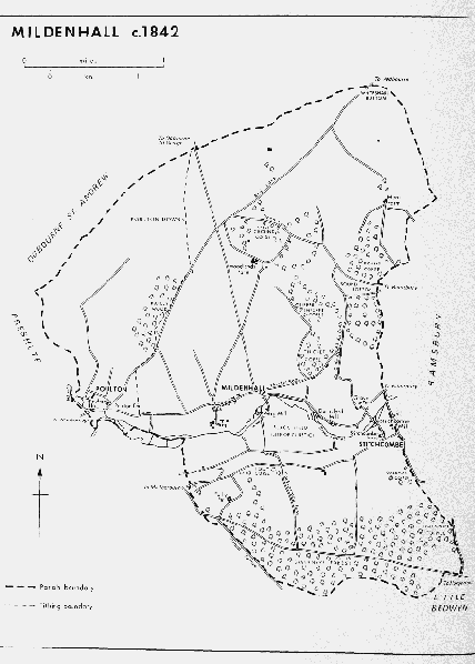
The parish of Mildenhall lies north and south of the Kennet immediately east of Marlborough. (fn. 1) South of the river and closely related to it by name was the Roman town Cunetio. (fn. 2) The parish included the tithings of Mildenhall, the name of which was frequently written and is still pronounced 'Minal', (fn. 3) Poulton, and Stitchcombe. A chapel at 'Selk' is supposed to have been in the north part of the parish and to have given its name to Selkley hundred but evidence of its existence is tenuous. (fn. 4) The probable absence of any church between Mildenhall and Preshute in the Anglo-Saxon period may have prompted the early extension of the parish westwards and southwards to include the lands of Poulton and Stitchcombe. Mildenhall, Poulton, and Stitchcombe were all townships in the 11th century. (fn. 5) The compact, roughly triangular, parish has its western point at Bay Bridge on the river Og. The south-west boundary follows the Og to the Kennet, the Kennet for 1 km., turning south to the London-Bath road which it follows to the Grand Avenue in Savernake forest, and the Grand Avenue for 1 km. before turning east to the south-east point of the triangle on the London-Bath road. From there the eastern boundary is marked by stretches of a lane to Stitchcombe and runs over the downs and up a dry valley to Whiteshard Bottom, the northern point, from where the north-west boundary runs above the valley of the Og and down into it to Bay Bridge.
Of the three tithings Mildenhall, c. 2,200 a. in 1838, was the largest and occupied the north and east parts of the parish. West of a road from Marlborough to Aldbourne was Poulton tithing, c. 800 a., and south of the Kennet was Stitchcombe, c. 1,000 a. (fn. 6) The total area of the parish was 4,177 a. (1,691 ha.) in 1891. (fn. 7) In 1901 it was increased by 46 a. from Preshute, most of which lay north of the London-Bath road and east of the G.W.R. line. Much of the land then added to Mildenhall was transferred to Marlborough in 1934 and thereafter Mildenhall parish measured 1,692 ha. (4,180 a.). (fn. 8)
The parish lies above 152 m. except near the rivers and in the south-east corner; the highest point, 221 m., is on the north-western boundary. The chalk which outcrops over the whole parish is covered on the lower slopes by clay-with-flints and a broad band of clay extends east and west over much of Stitchcombe tithing. (fn. 9) Much of the chalk downland was used as pasture and there was a large rabbit warren near the site of Warren Farm. Before the 19th century most of the arable lands of the parish were on the clay. Gravel soils in Sound Bottom, Whiteshard Bottom, and the dry valley bordered by Rabley Wood may also have been tilled. (fn. 10) Meadow land, much of it floated in the 16th century and later, is provided by the alluvium of the Og and particularly of the Kennet, beside which it is c. 400 m. wide. (fn. 11) Most settlement took place on the gravel of the river valleys, and on the river banks are the sites of several mills. Much of the parish's abundant woodland is on the clay and the largest area has always been south of the Kennet. All or a large part of Stitchcombe tithing lay within Savernake forest from the 13th century or earlier. (fn. 12) There were 365 a. of wood in the parish in 1838. Then, as in 1982, broad bands of scattered woodland stretched from Warren Farm south-east to Sound Copse and Thicket Copse, and south to Rabley Wood. (fn. 13)
Mildenhall c.1842
The chief evidence of pre-Roman activity in the parish, apart from several barrows and scattered artefacts, is a cemetery, possibly a war cemetery, of the early Iron Age 250 m. south of Mildenhall church. South-east of Mildenhall village in Black Field is the site of Cunetio. The town was a trading centre at the junction of roads from Bath, Winchester, and Cirencester, and possibly from Old Salisbury and Silchester (Hants). At its foundation it was apparently unfortified but in the 4th century it was enclosed by a stone wall, 16 ft. wide at its base, with bastions. The town probably survived as a small local market into Anglo-Saxon times, although only a few finds of that period have been made. The site of a smaller Roman settlement is 500 m. northwest of Forest Hill, formerly Folly, Farm. (fn. 14)
The course of the Roman road north from Cunetio is marked by a road from Mildenhall village which becomes a track north of Woodlands Farm and joins the Marlborough-Swindon road at Ogbourne St. George. The roads from Cunetio to Winchester and Old Salisbury are traceable south-eastwards and south-westwards from where they fork near the northern edge of Savernake forest. The road from Bath probably ran south of the Kennet but its course is not known. Part of it may have been the Roman road, identified in the 18th century, which ran north-west and south-east across Black Field. (fn. 15) In the 13th century an east-west road followed a more southerly course through Savernake forest, probably along a route similar to that of the modern London-Bath road. (fn. 16) That road, the main route through the parish since the early 18th century or before, was turnpiked in 1726. (fn. 17) Until the late 18th century the road through Sound Bottom, Dean Lane, may have been part of a main Hungerford-Marlborough road, and it linked Ramsbury with the old SwindonMarlborough road at the Old Eagle in Ogbourne St. Andrew. (fn. 18) In 1982 it was a track only. In 1773 and in the 20th century other principal roads were near the Kennet. North of the river is the Marlborough-Ramsbury road, south of it is that from Marlborough to Stitchcombe. (fn. 19) The two were probably linked by a bridge north of Werg Mill in the late 16th century and there was also a bridge at Stitchcombe in the early 18th century. (fn. 20) The road which leads north-eastwards from Poulton to Aldbourne was called Red Lane in the late 18th century and the 19th. Cock-a-troop Lane, 700 m. east of Forest Hill and only a path in 1982, and a steep and winding lane leading west and south from Stitchcombe linked the Marlborough-Stitchcombe and London-Bath roads. (fn. 21) From the London-Bath road rides lead north and south into Savernake forest. A section of the Swindon, Marlborough & Andover Railway was built across the parish near the Og and was opened in 1881. The line was closed to passengers in 1961 and for freight in 1964. (fn. 22)
In 1377 there were 122 poll-tax payers in Mildenhall parish, a little below the average for Selkley hundred. Tax assessments show the parish to have been one of the less prosperous of the hundred in both the 14th century and the 16th. (fn. 23) In 1801 there was a population of 376 and the total had risen to 501 by 1871. It had fallen to 422 by 1901 and later fluctuations followed boundary changes. Barnfield, a suburb of Marlborough, was built on land transferred to Mildenhall from Preshute in 1901. The population of that area was then 7 and had increased to 44 by 1911 and 95 by 1934, when most of the land was transferred to Marlborough. In 1971 the parish had 421 inhabitants. (fn. 24)
Mildenhall, which had 72 poll-tax payers in 1377, was by far the most populous tithing in the parish. It differed little in wealth from Stitchcombe tithing, however, and was less prosperous than average among the communities in the hundred. (fn. 25) The population was 281 in 1841. (fn. 26) Probably in the Anglo-Saxon period the site of settlement moved from Black Field to the north bank of the Kennet. The village spread north from Mildenhall church, near the river, along a lane leading to the crossroads at which the Marlborough-Ramsbury road and a track running north-east to Woodlands Farm meet. Beside the lane and near the church stand the oldest houses of the village, some of them timberframed and thatched. Church Farm and Glebe House south of the church and cottages west and north of it may date from the 17th century and early 18th. The rectory house demolished in the mid 19th century stood west of the lane opposite the church (fn. 27) and in 1982 a pair of gate pillars marked the entrance to its grounds. No site of a manor house has been traced in the village but the demesne farmstead of Mildenhall manor stood north of the rectory house in the early 19th century. (fn. 28) The farmhouse was later demolished but some farm buildings remained in 1982. In the 18th century the village extended 400 m. east of the crossroads along the Ramsbury road, which thus became its principal street. (fn. 29) Surviving houses of the 18th and early 19th century beside the street include Hawthorn Cottage and Home Farm. The Horse Shoe, north of the street, was a beerhouse in the mid 19th century. (fn. 30) Many cottages date from the later 19th century and some were probably built in the 1860s when new building attracted new residents to the village. (fn. 31) In the 1880s the eastern extent of the village was marked by the school, built at the junction of the Marlborough-Ramsbury road and the Roman road to Cirencester. (fn. 32) In the 20th century council houses were built east of that junction and private houses were built at the west end of the village. Infilling included council houses built south of the street and a village hall, notable for its steeply pitched roof above low walls, built north of the street in 1974. (fn. 33) Mildenhall House, a former rectory house built in the 1860s, stands south of the Marlborough-Ramsbury road 400 m. west of the village. (fn. 34) Older settlement sites beside the road east of the village include those of Durnsford Mill and Lucky Lane, a former farmhouse. Of the outlying farmsteads, the earliest was at or near the modern Woodlands Farm. There was probably a farmstead at Woodlands in the 15th century, and in the 16th century tenants of the demesne farm of Mildenhall manor lived there. In the late 17th and early 18th century the lord of the manor had a house there. (fn. 35) In 1982 there were two farmhouses, one built in the 19th century, the other in the 20th. The sites of Mere Farm and Grove Farm have been in use since the 16th century or earlier. (fn. 36) A large house of unusual design was being built at Mere in 1982. Grove Farm is a red-brick house of the 18th century; another farmhouse was built north of it in 1979. (fn. 37) Warren Farm was established in the 19th century and Mildenhall Warren Farm, 500 m. north of it, in the 20th. (fn. 38)
Poulton. Medieval tax assessments show Poulton to have been the poorest of the tithings of Mildenhall and in 1377, when there were only eight poll-tax payers, it was one of the smallest communities in Wiltshire. (fn. 39) In the late 18th century the hamlet consisted of two farmsteads, later called Poulton House and Poulton Farm, which stood a little north of the confluence of the Kennet and the Og. Poulton Farm, then known as Little Poulton, (fn. 40) was rebuilt in the 19th century. There were 29 inhabitants of the hamlet in 1841 and numbers may have increased in the late 19th century and the early 20th when several cottages were built east of the Poulton-Aldbourne road. (fn. 41)
Stitchcombe. There were only 42 poll-tax payers in Stitchcombe in 1377. (fn. 42) In the early 18th century and in the 20th there were three small settlements in the tithing, Stitchcombe hamlet, a group of houses around Werg Mill 500 m. east of Mildenhall church, and Folly, later Forest Hill, Farm. (fn. 43) Cottages were built near the northern end of Cock-a-troop Lane in the late 18th century and the 19th. (fn. 44) In 1841 the population of the tithing was 127. (fn. 45)
The buildings of Stitchcombe hamlet stand beside a road joining the roads from Marlborough on each side of the Kennet. West of the road is the site of Stitchcombe Mill, only part of which remains. On the steep slopes south of the mill is Stitchcombe House, a farmhouse mainly of the 19th century which may incorporate parts of an earlier building in the eastern service block. Farm buildings and cottages stand east and north of the house. In the late 18th century there were several houses near Werg Mill beside a lane leading south and west from Mildenhall village (fn. 46) but none seems to have survived. Houses of the 19th century, some of them thatched and timberframed, include the mill house and cottages west of it. Houses and bungalows were built west and north of the mill house in the 20th century. At Forest Hill only an 18th-century lodge in Gothic style (fn. 47) and the 19th-century farmstead lay within Stitchcombe tithing.
Manors and Other Estates.
Between 757 and 786 Cynewulf, king of Wessex, gave lands, later MILDENHALL manor, to Bica his thegn who granted them to Glastonbury abbey. A grant made to the abbey by King Edred between 946 and 955 probably confirmed the earlier gift. (fn. 48) The abbey held Mildenhall in 1086 and was overlord of the manor c. 1230 and in 1282. (fn. 49)
Mildenhall was held of Glastonbury abbey by Hugolin before 1086 and by Edward, probably Edward of Salisbury, in that year. (fn. 50) It apparently passed to Edward of Salisbury's son Walter (d. 1147) and Walter's son Patrick, first earl of Salisbury, and descended with the earldom to Margaret Longespee, for in 1275 Margaret's husband Henry de Lacy, earl of Lincoln, was lord of a knight's fee in Mildenhall in her right. (fn. 51) Their daughter Alice, countess of Lincoln and of Salisbury, and her husband Sir Ebles Lestrange granted the lordship to Hugh le Despenser, earl of Winchester, in 1325. (fn. 52) After Despenser's execution in 1326 the lordship passed to the Crown. (fn. 53)
William Marshal, earl of Pembroke (d. 1219), was tenant in demesne of the manor which he granted to his daughter Sibyl and her husband William de Ferrers, earl of Derby. (fn. 54) In 1241 Ferrers conveyed the manor to Gilbert Basset (d. 1241), husband of his daughter Isabel, in exchange for lands previously granted to Basset. In 1242–3 it was held by Isabel and her husband Reynold de Mohun (d. 1256). (fn. 55) Isabel was succeeded in 1260 by her son William de Mohun (d. 1282), whose relict Beatrice (fl. 1292) retained Mildenhall as part of her dower. (fn. 56) In 1294 the manor was conveyed to a trustee for William's son Reynold, after whose death while a minor in or before 1297 his father's estates were divided. Mildenhall was allotted to William's daughter Mary and her husband John de Meriet. (fn. 57) At John's death in 1327 it passed to Mary's kinsman John de Mohun, Lord Mohun, (fn. 58) and probably before 1330 it was granted for life to John of Mere (d. c. 1350) and his wife Eleanor (fl. 1352). (fn. 59) The reversion of the manor passed at the death of John, Lord Mohun, in 1330 to his grandson John de Mohun, Lord Mohun, who in 1352 granted it to Bartholomew Burghersh, Lord Burghersh (d. 1355). (fn. 60) Burghersh's son Bartholomew, Lord Burghersh, conveyed the manor to Sir Thomas Hungerford in 1362. (fn. 61)
Hungerford, who in 1385 received a grant of free warren in his demesne at Mildenhall, (fn. 62) was succeeded in 1397 by his son Sir Walter, later Lord Hungerford (d. 1449). The manor passed in turn to Walter's son Robert, Lord Hungerford (d. 1459), (fn. 63) and Robert's son Robert, Lord Hungerford and Moleyns, who conveyed it to his son Sir Thomas in 1460. (fn. 64) After Sir Thomas's attainder in 1469 Mildenhall was retained by or immediately restored to his relict Anne who held it later in the same year. A grant of the manor to Richard, duke of Gloucester, in 1474 was presumably without effect. In 1485 the Hungerford title to the manor was assured by the reversal of the attainder of 1469. (fn. 65) In 1493 Anne and her husband Hugh Vaughan conveyed the manor for Anne's life to trustees for her daughter Mary Hungerford, Baroness Botreaux, wife of Edward Hastings, Lord Hastings (d. 1506). (fn. 66) After Anne's death in 1522 Mildenhall was probably retained by Mary (d. 1533). In 1535 it was, like other estates belonging to the Hungerford family, a subject of litigation between Mary's son George Hastings, earl of Huntingdon, the heir general, and Sir Walter Hungerford, created Lord Hungerford in 1536, who as grandnephew of Sir Thomas Hungerford (d. 1469) was the heir male. (fn. 67) A settlement was reached by arbitration and the manor was allotted to Hungerford. On his attainder in 1540 it was forfeited to the Crown and it was granted as jointure in 1541 to Catherine Howard (d. 1542) and in 1544 to Catherine Parr (d. 1548). (fn. 68) In 1547 the reversion was granted to Edward Seymour, duke of Somerset, (fn. 69) and the manor passed to the Crown on his attainder in 1552. In 1554 it was restored to Walter, son of Walter, Lord Hungerford (d. 1540). (fn. 70) Walter was succeeded in 1596 by his brother Sir Edward (d. 1607) who settled the manor on his grandnephew Sir Edward Hungerford. (fn. 71) In 1648 it passed to the younger Sir Edward's half-brother Anthony Hungerford (d. 1657) whose son Sir Edward sold it in 1673 to Henry Nourse. (fn. 72) Nourse (will proved 1705) (fn. 73) was succeeded by his daughter Sarah and her husband Charles Finch, earl of Winchilsea (d. 1712). (fn. 74) In 1731 Sarah and her husband William Rollinson sold Mildenhall manor to Charles Bruce, Baron Bruce, later earl of Ailesbury. (fn. 75) It passed with the Ailesbury title to George Brudenell-Bruce, marquess of Ailesbury, who offered it for sale in 1929 as two farms, each of c. 200 a. (fn. 76) Home farm was sold to D. M. Jeans and, after 1931, to A. W. Gale. In 1982 Gale & Ainslie Ltd. owned it. (fn. 77) Grove farm was sold to Mrs. L. M. Edwards (d. 1946), who was succeeded by her son R. H. Edwards (d. 1971). In 1972 Mr. G. Young bought the farm and in 1973 sold most of the lands to Mr. and Mrs. J. S. Burrows, the owners in 1982. (fn. 78)
A copyhold at Woodlands, which from the late 16th century or earlier had been held by the tenants of the demesne lands of Mildenhall manor, had been taken in hand as WOODLANDS farm by 1695. (fn. 79) Before 1742 it was sold by Charles, earl of Ailesbury, to Charles Stanhope. (fn. 80) The farm passed by sale or inheritance from Stanhope's relict (fl. 1751) to John Calcraft (d. before 1769) (fn. 81) and descended in the Calcraft family probably from father to son. It was held by Thomas Calcraft in 1769 and 1776, (fn. 82) by John Calcraft the younger in 1780, and by Thomas Calcraft the younger from 1782 until c. 1829. (fn. 83) Thomas was succeeded by his son John (will proved 1830) (fn. 84) and by his son-in-law the Revd. George Wyld. George's son the Revd. Thomas Wyld inherited the farm in 1836. (fn. 85) It was sold in 1858 to Richard Pocock, and in 1878 probably to Francis James Simpkins, the owner in 1895. (fn. 86) Further sales took place in 1896 and 1911, and in 1923 the farm belonged to C. R. E. Powell. (fn. 87) His relict Florence held it in 1932, as did W. E. Powell, presumably their son, in 1935. (fn. 88) After 1939 it was sold to a member of the Dawson family, and members of that family were owners in 1982. (fn. 89)
A substantial house at Woodlands, in which Henry Nourse, lord of Mildenhall manor, lived in the late 17th century, was probably on the same site as that occupied by tenants of the demesne farm in 1586. (fn. 90) Nourse's house was standing c. 1720 (fn. 91) but was demolished before 1792 when stone pillars from the entrance were used for the north portico of the central block of the building which became C House of Marlborough College. (fn. 92)
Demesne lands of Mildenhall manor, known as LOWER and later as CHURCH farm, were sold before 1742 to Charles Stanhope and passed with Woodlands farm to John Calcraft (will proved 1830). (fn. 93) Lower farm was inherited by Calcraft's sister Arabella (d. 1841), wife of William St. Quintin. (fn. 94) She was succeeded by her son the Revd. G. D. St. Quintin (d. 1873) and he by his nephew Geoffrey St. Quintin, the owner in 1895. (fn. 95) In or before 1923 the farm was bought by D. M. Jeans and thereafter it passed with Home farm. (fn. 96)
Between 801 and 805 Eahlmund, bishop of Winchester, granted an estate to Byrhtelm and received in exchange lands in various places including Mildenhall. (fn. 97) Nothing more is known of any holding there belonging to the see.
Robert de Mercinton gave lands in Mildenhall, perhaps Mildenhall in Wiltshire, for the foundation of the abbey of Netley (Hants), which took place in 1239. They were the subject of an exchange between the abbey and the Crown in 1241 (fn. 98) but no further reference to them has been found.
The hospital of St. John the Baptist in Marlborough held land in Mildenhall in 1535. (fn. 99) The land was granted with the hospital's other estates to the mayor and burgesses of Marlborough in 1550 to endow the grammar school. (fn. 100) Before 1584 it was sold to Sir Walter Hungerford and was added to Mildenhall manor. (fn. 101)
In 1584 John Pearse held a farm called MERE. (fn. 102) In 1596 he settled half the farm on his son John, reserving the other half to himself and his wife Elizabeth for life. (fn. 103) The elder John died in or before 1616, the younger in or before 1642. Mere farm was held by William Pearse in 1642 and in 1650 by Thomas Pearse, who sold it in 1652 to William Blissett. (fn. 104) On Blissett's death c. 1672 it passed to Robert Blissett (fl. 1705). In 1733 John Tarren sold the farm to Nathaniel Merriman (will proved 1743) or his son Nathaniel (d. 1781). (fn. 105) The younger Nathaniel's executors sold it in 1792 to Thomas Brudenell-Bruce, earl of Ailesbury, and it became part of the Mildenhall manor estate. (fn. 106) Mere was sold as a separate farm in 1929 to a Mr. Crook, (fn. 107) and in 1932 was bought by members of the Wight family. In 1975 it passed to Mr. G. R. Wight, the owner in 1982. (fn. 108)
POULTON was held by Toni in 1066 and by Humphrey Lisle in 1086. (fn. 109) Humphrey's estates formed the nucleus of the barony of Castle Combe, and the overlordship of Poulton passed with Broad Hinton manor and the barony to Giles de Badlesmere, Lord Badlesmere (d. 1338). (fn. 110) At the division of Badlesmere's estates in 1341 a knight's fee in Poulton was allotted to his sister Margaret and her husband John Tiptoft, Lord Tiptoft, and ½ fee there to another sister Margery and her husband William Ros, Lord Ros. (fn. 111) Margery's holding in Poulton may later have been acquired by Tiptoft or his successors; both holdings passed with Castle Combe to members of the Scrope family. The last overlord to whom reference has been found was George Scrope (d. 1604). (fn. 112)
Reynold de Dunstanville, husband of Humphrey Lisle's daughter Adelize, granted 5 hides at Poulton to Baldwin, a merchant of Wilton. A confirmation of the endowments of Tewkesbury abbey, dated 1114, mentioned tithes from Poulton given to the abbey by Adelize after Reynold's death. Adelize's gift was possibly not tithes, to which there is no later reference, but the 5 hides given to Baldwin, since the abbey is said to have compensated him for their loss. (fn. 113) LITTLE POULTON manor was held by the abbey before c. 1210 when it was confiscated by the Crown. (fn. 114) It was restored soon afterwards and after the Dissolution was apparently sold to a St. John; members of that family had formerly been tenants. In 1588 Nicholas St. John settled the manor on his son Sir John (fn. 115) and thereafter it descended with Bincknoll manor in Broad Hinton in the St. John family. (fn. 116) In 1819 George St. John, Viscount Bolingbroke, sold it to Charles Brudenell-Bruce, earl of Ailesbury. (fn. 117) It passed with the Ailesbury title and in 1929, with most other land in Poulton, was offered for sale as Poulton farm by George, marquess of Ailesbury. It was sold then or shortly afterwards to F. J. Sainsbury. In 1936 it was sold by Sainsbury's executors to E. H. North. (fn. 118) Mr. H. E. Hill bought the Poulton estate, 800 a., c. 1945 and owned c. 500 a. there in 1982. (fn. 119)
An estate, later GREAT POULTON manor, was held of Humphrey Lisle's successors by Thomas de Cardeville in the late 12th century. Thomas was succeeded by his sons William (d. before 1222) and Adam (fl. 1227). (fn. 120) The estate was held by Walter de Cardeville in 1242–3 and by William de Cardeville in 1275. (fn. 121) In 1324 a messuage and 1 carucate of land, perhaps part of the estate, were settled by Roger Poulton on Thomas Poulton and his wife Isabel with remainder to John Poulton. (fn. 122) Thomas held lands in Poulton in 1338, and in 1399 an estate, probably Great Poulton manor, was conveyed to another Thomas and Isabel Poulton by trustees, with remainder to Thomas Poulton. (fn. 123) That last Thomas, later bishop of Worcester (d. 1433), was succeeded by George Poulton his nephew, (fn. 124) whose relict Isabel held the estate in 1454. (fn. 125) From Isabel it passed, by what right is not known, to John Crook (d. c. 1509), and in turn to John's son Robert and Robert's son George. George's right to part of the estate was disputed c. 1535 by William Bush, who claimed it by inheritance from his father Thomas. (fn. 126) In 1557 William's son Thomas was seised of the whole manor, which he then sold to Robert Were or Brown. (fn. 127) Robert (will proved 1570) was succeeded by his son Richard, who by will proved 1577 gave the manor to his son Robert (will proved 1592). (fn. 128) Robert was succeeded by his brother Clement (d. 1602), by Clement's son Richard, (fn. 129) and by Richard's son Alexander Brown (fl. 1665). (fn. 130) In or before 1670 Alexander devised the manor to Cornelius Cornwallis, husband of his daughter Margaret. (fn. 131) By will proved 1674 Cornwallis devised it to trustees to be sold but in 1693 the trustees conveyed it to another Cornelius Cornwallis, perhaps his son. (fn. 132) The younger Cornelius sold the manor in 1698 to William Lydiard, whose relict Elizabeth conveyed it to their son Stephen in 1712. (fn. 133) Stephen was succeeded in 1719 by his daughter Elizabeth, sometimes called Stephania Elizabeth. By will proved 1739 she devised the manor for life to her mother Elizabeth Lydiard (fl. 1748) with remainder to her sister Frances, later wife of John Hart. (fn. 134) In 1777 Frances Hart sold the manor to Thomas Brudenell-Bruce, earl of Ailesbury. (fn. 135) In 1929 it was sold with Little Poulton as a single farm. (fn. 136)
Poulton House, built in 1706, (fn. 137) is of brick with stone dressings and has a south front of seven bays. The original principal and secondary staircases and a moulded plaster ceiling survive, but otherwise the interior was altered, apparently in the 19th century. The principal windows were then sashed and a canted bay was added on the south-east side of the house. The rear service wing was also built in the 19th century.
In 1066 and 1086 Gode held lands which later became STITCHCOMBE manor. (fn. 138) In 1242–3 Stitchcombe was held of William de Beauchamp (d. 1269) and in 1275 his son William, earl of Warwick, was overlord. The heirs of Hubert Busati were then intermediate lords of the manor. (fn. 139)
Robert of Stitchcombe held lands in Stitchcombe, probably Stitchcombe manor, in 1167 and was succeeded in or before 1200 by Sir Richard of Stitchcombe. (fn. 140) In 1217 Sir Richard's lands were granted at the king's pleasure to Reynold of Whitchurch but in 1242–3 Robert of Stitchcombe held the manor. (fn. 141) Robert (fl. 1249) was succeeded by Reynold of Stitchcombe (d. in or before 1264). (fn. 142) Reynold's heir, apparently a minor in 1286, may have been Roger of Stitchcombe, who held the manor in 1316. (fn. 143) In 1325 it was settled on Roger for life with remainder to Hildebrand of London. (fn. 144) Roger died after 1332, and in 1359 Hildebrand's son Robert held the manor. (fn. 145) After Robert's death c. 1391 it was settled for life on his relict Elizabeth (d. before 1403) with remainder to John Lovel, Lord Lovel, probably her brother, and his heirs. (fn. 146) Lovel (d. 1408) held the manor jointly with his wife Maud, who apparently conveyed it to Sir William Esturmy or trustees for him in or before 1418. (fn. 147) After Esturmy's death in 1427 it passed to his grandson Sir John Seymour (d. 1464), (fn. 148) and in turn to Seymour's grandson John Seymour (d. 1491 or 1492) and that John's son John, later Sir John, Seymour. In 1536 the manor passed to the younger Sir John's son Edward, Viscount Beauchamp, later earl of Hertford and duke of Somerset. (fn. 149) With other lands forfeited at Somerset's attainder in 1552, Stitchcombe was restored to his son Edward, created earl of Hertford in 1559. It passed with the earldom of Hertford and later with the dukedom of Somerset to John Seymour, duke of Somerset, (fn. 150) and at his death in 1675 it was inherited by his sister Elizabeth (d. 1697), wife of Thomas Bruce who succeeded to the earldom of Ailesbury in 1685. Thereafter the manor passed with the Ailesbury title and between 1731 and 1929 with Mildenhall manor. (fn. 151) In 1939 George Brudenell-Bruce, marquess of Ailesbury, granted a lease for 999 years to the Forestry Commission of the part of Savernake forest which lay within the tithing. (fn. 152) In 1950 he conveyed the residue of the estate at Stitchcombe to the Crown Estate Commissioners, the owners in 1982. (fn. 153)
Alice, wife of Thomas Cooke, held HENDIS farm in Stitchcombe tithing and was succeeded c. 1540 by her son John Marchant. (fn. 154) In 1573 Marchant sold the farm to John Cornwall (d. 1611), whose daughter Bridget, relict of Sir William Jordan, held it in 1629. Marchant's son Robert and his grandnephew William Gough contested the validity of that sale and Bridget's title to the farm, probably without success. (fn. 155) Her son Sir William Master held the farm in 1638 and sold it in 1649 to Alexander Staples. It was bought from Staples in 1664 by Adam Peddington or Tuck (fn. 156) who released it in 1680 to another Adam Peddington, probably his son. The younger Adam sold the farm in 1681 to William Bailey. (fn. 157) In 1701 Bailey conveyed it to his son William who sold it in 1710 to William Hillear. (fn. 158) The farm passed c. 1713 to Hillear's son William who sold it in 1739 to Thomas Bruce, earl of Ailesbury. (fn. 159) Thereafter, under the name of Folly farm and later of Forest Hill farm, it passed with Stitchcombe manor. (fn. 160)
A small parcel of land in Stitchcombe tithing may have been among lands granted by Robert Grafton, rector of Mildenhall, and others to St. Margaret's priory, near Marlborough, in 1412. (fn. 161) Lands near Puthall Farm in Little Bedwyn held by the priory at the Dissolution were part of the jointure of Anne of Cleves in 1539. (fn. 162) In 1542 they were granted to Edward Seymour, earl of Hertford, and added to Stitchcombe manor. (fn. 163)
Economic History.
Mildenhall. The estate of Glastonbury abbey, said to include 15 hides in the 10th century, (fn. 164) was assessed at 10 hides in 1066. In 1086 there were only 6 ploughteams, although there was land for 10. The demesne, on which there were 2 teams, was of 4 hides, and 15 villeins and 5 bordars had 4 teams. There was pasture ½ league long and 3 furlongs broad and 10 a. of meadow. The estate increased in value from £12 in 1066 to £18 in 1086. (fn. 165)
Most of the arable lands of Mildenhall tithing lay in three fields, West, Middle, and East or Thicket fields, in a band on the north side of the Marlborough–Ramsbury road. A fourth field, Wore or Oare, lay south of the road and west of the church. There was also tillage further north again, probably in Sound Bottom; a field there may have been open in the 14th century but was partly or wholly inclosed in the 16th. (fn. 166) In the 16th century there was common pasture for sheep on Greenhill, south of Sound Bottom, and on 'Hockdown' and 'Rawdown', which presumably lay in the north and west parts of the tithing. There was also a common cow down, the location of which is not known. Burridge down provided demesne pasture, which was probably several, and was the site of a rabbit warren. (fn. 167)
In the late 13th century sheep-and-corn husbandry was extensively practised on the demesne of Mildenhall manor: in addition to the downland pastures there were arable lands assessed at 200 a. in 1282, when there were 24 a. of meadow, and 360 a. in 1297. Much of the work on the demesne may have been done by the customary tenants whose holdings, for which rents totalling over £5 were paid, may also have been large, (fn. 168) although nothing is known of their number. Some services, including boonworks of 24, 20, and 18 persons to cut, bind, and carry the demesne corn, were performed in the 15th century. (fn. 169) There was demesne pasture for 400 sheep in the late 13th century; the size of the flock rose to between 500 and 600 in the late 14th and early 15th centuries. Additional labour was often hired for shearing: 30 people were employed in 1380. From the mid 14th century Mildenhall was one of several manors of the Hungerford family which were linked in a system of sheep rearing, though it may not have been fully integrated with the others: there are only occasional references to ewes sent from Mildenhall to Farleigh Hungerford, in Norton St. Philip (Som.), or fleeces to Heytesbury, the principal collection centres for the estates. (fn. 170) From 1425 or earlier the demesne arable and meadow and small parcels of demesne pasture, presumably lowland pasture, were leased in portions and from 1439 the demesne was leased as a single farm. Among the 15th-century tenants of the farm were members of the Goddard family. (fn. 171)
The demesne warren, first mentioned in 1448, (fn. 172) was leased in 1453 to three tenants, whether jointly or in portions is not known, and thereafter the warrener was probably always a lessee. In the 16th century and the early 17th the warren was leased with the demesne farm. (fn. 173) Estimates of its size vary from 250 a. in 1673 to 400 a. in the early 18th century. By 1673 a lodge had been built for the warrener. (fn. 174) A reference to the warren of 1731 is the latest which has been found. (fn. 175)
In addition to the demesne farm and the presumably extensive customary holdings of Mildenhall manor, details survive of two medieval freeholds in the tithing. A yardland at Woodlands, called Hamstalls in 1313, had become a small several holding by the 16th century. (fn. 176) The demesne farm of the rectory estate included 1 carucate and meadow valued at 10s. a year in 1341. The rector also received rents and services valued at 16s. from four customary tenants. (fn. 177)
In the 16th century there were five principal farms in the tithing, the demesne farm of Mildenhall manor, Woodlands and Grove farms, both then copyholds of the manor, Mere farm, and the glebe. In 1586 the demesne farm was leased to William Jones, and members of that family held it until the mid 17th century. (fn. 178) It consisted of 108 a. in the open fields, 20 a. of inclosed arable land, 23 a. of meadow, and 60 a. of wood, with 200 a. of pasture, most of it on the downs in the north part of the tithing. The lessee also had pasture on the cow down from 21 December until 25 March. In the 1670s the farm included c. 850 a., of which perhaps 400 a. was the warren; the downland pasture was by then inclosed. (fn. 179) Lower farm had by then been separated from other demesne land and included 120 a. of several arable. In the late 16th century the copyholds of Mildenhall manor amounted to 18½ yardlands, including c. 800 a. of arable in the open fields and pasture in common for 1,500 sheep, in eleven holdings. Two holdings were of 4 yardlands each, the later Woodlands and Grove farms. Woodlands included 104 a. in severalty, of which 54 a. were arable land and 50 a. pasture, and pasture in common for 400 sheep. Grove farm included 82 a. of pasture in small closes, common pasture for 400 sheep, and 11 a. in the open fields, and no other arable land. (fn. 180) By 1770 Woodlands and some smaller holdings had been converted to freeholds or leaseholds. (fn. 181) Mere farm, east of Woodlands, consisted of c. 75 a., all inclosed, in 1642 and 1733. (fn. 182) The rector's estate changed little between the late 16th century and the 18th; it included some 37 a. in the open fields, 26 a. of inclosed land, and four ½-yardlands held by tenants. (fn. 183) All the principal farms were worked by tenants in the late 18th century. (fn. 184)
The demesne farm included 11 a. of watered meadow in 1586, and in 1637 permission was given in the manor court for the lessee to divert water from the Kennet to meadows 'in the curtilage of the manor', probably close to the farmstead near the church. (fn. 185) In the late 17th century there were c. 45 a. of watered meadow in the tithing. (fn. 186)
Although the northern part of the tithing was mostly several by the 1670s, there was probably still some common pasture on the downs. (fn. 187) By the late 18th century the downland had been inclosed, but no record has been found of the process of inclosure. The fields which bordered the Marlborough-Ramsbury road remained open until 1776. An agreement, confirmed by an Act of 1779, was then made for the inclosure of 476 a. Allotments, totalling 478 a., were made of 251 a. to the lord of Mildenhall manor, including c. 80 a. for copyhold land, of 165 a. to Woodlands farm, and of 62 a. to the rector, presumably for both demesne and copyhold lands. (fn. 188) By 1838 most small copyholds and leaseholds had been absorbed into the larger farms. Land had also been transferred from Mildenhall farm, the demesne farm, then c. 250 a., to the farms of the Woodlands estate, Lower farm, 593 a. with buildings south of the church, and Woodlands, 566 a. On Grove farm were c. 240 a., on Mere farm 141 a., and on Rectory farm 159 a. with buildings west of the church. Parts of the downland had by then been ploughed and the farms were mainly arable. Only Lower farm had a substantial proportion of pasture, including 174 a. on the downs. (fn. 189) In the late 19th century it was a dairy farm. (fn. 190) Arable farming in the tithing declined in the late 19th and early 20th centuries. By 1878 Woodlands had been divided into two farms, Woodlands, c. 340 a., and Warren, c. 200 a., and by 1896 most of the lands of both had been converted to pasture. (fn. 191) Mildenhall and Grove farms, which had been merged as an arable farm described as fertile but badly managed in 1867, (fn. 192) were separate in 1929. Each was then of c. 200 a. and each included c. 50 a. of pasture. Mere then measured 221 a., approximately half of which was pasture, (fn. 193) and in 1982 it included c. 100 a. of grassland. (fn. 194) After 1929 Home, formerly Mildenhall, farm, Lower farm, and part of Warren farm were merged as Church farm, a mixed farm worked from buildings south of the church and including a trout farm in 1982. (fn. 195) In the 1970s a dairy herd was established at Grove farm and 12 a. were worked as a vineyard. (fn. 196)
There was woodland ½ league long and 3 furlongs broad at Mildenhall in 1086. (fn. 197) In the Middle Ages sales of wood and underwood were an important part of the lord of Mildenhall manor's income. (fn. 198) In 1586 c. 60 a. of wood, all of hazel and ash and including Thicket Copse and Sound Copse, were in hand and farms in the tithing included a few acres of woodland each. (fn. 199) The area of demesne woodland had risen to 100 a. by 1673 and 120 a. by 1838; (fn. 200) it changed little thereafter. (fn. 201)
A rent of 30s. was paid for a mill at Mildenhall in 1086, (fn. 202) and in 1453 a mill was leased by the lord of Mildenhall manor. (fn. 203) Stockham Mill, a corn and fulling mill, was leased by the lord of the manor in 1586. (fn. 204) From the early 17th century it was sometimes called Durnsford Mill. (fn. 205) Fulling apparently ceased after 1745 but in the 1790s there were still spinners at Mildenhall; they were then losing work because of the introduction of the jenny elsewhere in the county. (fn. 206) The corn mill had three pairs of stones driven by a 12-ft. water wheel in 1867, and in 1898 both water and steam power were used. (fn. 207) It ceased working between 1903 and 1911. (fn. 208)
Poulton. In 1086 Poulton was an estate of 10 hides, of which 8 were in demesne. There were only 3 ploughteams although there was land for 4; there were 2 teams and 2 serfs on the demesne and 2 villeins and 7 bordars had 1 team. There were 4 a. of meadow, 10 a. of pasture, and 8 a. of wood. The estate was valued at £8, as it had been in 1066. (fn. 209)
Little more is known of agriculture in the tithing in the Middle Ages but the location of arable land and pasture was probably similar then and in the 18th century, when Poulton Downs and a cow down east of Poulton provided common grazing. South and south-west of the downs were the open fields of the tithing. (fn. 210) The 11th-century estate was divided into moieties. In 1210 Little Poulton manor was valued at £5 10s., of which 30s. was rent paid by tenants. There were 100 sheep on the estate. (fn. 211) Great Poulton manor comprised 5 hides in 1223 and was valued at £10 in 1339. (fn. 212) The only land in the tithing not part of either manor was part of the rector's glebe, said to be ½ yardland in the late 16th century. (fn. 213)
By the late 18th century any copyhold or leasehold lands had been absorbed into the two principal farms. The two farms had equal shares in the pasture of Poulton Downs and the cow down, which measured 206 a. and 26 a. respectively. (fn. 214) Great Poulton farm apparently included the larger proportion of arable lands, c. 200 a. in 1777. Some 12 a. of meadow and 12 a. of Rabley Wood then belonged to that farm and 40 a. of the wood to Little Poulton farm. (fn. 215) Lessees worked the larger farm from 1748 or earlier and the smaller from the late 18th century. (fn. 216) Large parts of the fields and downs were still open in the late 18th century but the process of inclosure was eased c. 1810 when the same tenant leased both farms and in 1819 when the farms were held by one owner. (fn. 217) Under an Act passed in 1815 inclosure took place in or before 1819, although the formal award was not made until 1824. Two allotments were made. The larger, 569 a., was all part of Poulton farm. The smaller, 43 a., was made to the rector. (fn. 218) In 1838 Poulton farm consisted of 348 a. of arable, 293 a. of pasture, of which 220 a. were downland, and 13 a. of water meadow. Rabley Wood, 66 a., was then in hand. (fn. 219) In 1929 Poulton was a corn and dairy farm of 750 a., including some land in Preshute and in Mildenhall tithing, and was worked from buildings east of Poulton House. (fn. 220) In 1982 it was a farm of c. 500 a. and other lands in the tithing were worked with those of farms in Mildenhall tithing. (fn. 221)
In 1086 there was a mill valued at 5s. on Humphrey Lisle's Poulton estate. (fn. 222) The prior of Ogbourne had a water mill at Poulton in the 12th century, and in the 13th he claimed the right to send a cart into Marlborough to collect corn for grinding. (fn. 223) The mill was apparently working in 1342 (fn. 224) but no further reference to it has been found. Its site may have been that of a mill which was part of Great Poulton manor in 1606 and which stood beside the Og west of Poulton House. (fn. 225) The mill was leased with Great Poulton farm in the 18th century but was destroyed before 1838. (fn. 226)
A royal fulling mill was said in 1215 to stand between Marlborough and Poulton. Elcot mill in Preshute was probably the one meant. (fn. 227)
Stitchcombe. There was said to be 1½ hide in demesne at Stitchcombe in 1084 but the whole estate was assessed at no more than 1 hide in 1086. There was then land for 3 ploughteams, of which 1 was held in demesne and 2 were held by 2 villeins and 5 bordars. The estate was valued at 50s. (fn. 228)
No pasture in Stitchcombe was mentioned in the Domesday survey and grazing was probably scarce in the Middle Ages. Common pasture for sheep may have been limited to Stitchcombe down, east of Cock-a-troop Lane, and Werg down, north-west of Forest Hill Farm, which were still open in the 18th century. Grazing rights on Stitchcombe down may have belonged to the lord or farmer and tenants of Stitchcombe manor and those on Werg down to the owners and tenants of Hendis, later Forest Hill, farm and to those living near Werg Mill, but there is no positive evidence of such a division. In the 18th century and probably earlier there was pasture for cattle of the lord and tenants of Stitchcombe manor in Savernake forest. Apart from meadows near the Kennet most land north of the forest was open arable fields. (fn. 229) In the late 13th cen- tury the bishop of Salisbury had rights of chase of hares and foxes in Stitchcombe, probably as an extension of his rights of chase in Ramsbury. (fn. 230)
No detail survives of the working of a demesne farm or any copyhold of Stitchcombe manor before the 18th century. In the mid 16th century Hendis farm included 20 a. of inclosed pasture and arable and probably also feeding rights on the downs. (fn. 231) Additional lands were bought and the farm included 70 a. of inclosed arable land in 1664 and 108 a. in 1680. (fn. 232) An agreement of 1703 may have completed the division of the open fields. A map of 1716 showed the whole tithing, except the downs and the forest, divided into small several fields, with those of the demesne of Stitchcombe manor, later called Stitchcombe farm, and of other holdings intermixed. Stitchcombe farm then consisted of 261 a. of arable land, 9 a. of dry meadow and 17 a. of water meadow, 40 a. of woodland, and 25 a. of pasture. (fn. 233) In 1751 there were ten copyholds and eight leaseholds, including Hendis farm. The smaller holdings had been absorbed by two larger farms by the early 19th century. (fn. 234) Folly farm, derived from Hendis, consisted of c. 200 a. in the western part of the tithing in 1838 and Stitchcombe of c. 460 a. in the eastern part. Both were principally arable, each having only c. 20 a. of downland pasture. (fn. 235) The area of grassland on each had increased slightly by 1867, and in the late 19th century arable land was probably converted to pasture in Stitchcombe as in the parish's other tithings. (fn. 236) Dairy herds were kept in the early 20th century but after 1960 both Stitchcombe and Forest Hill were arable and stock farms. (fn. 237)
There were 50 a. of wood at Stitchcombe in 1086, (fn. 238) and in the early 13th century the whole tithing lay within the boundary of Savernake forest. The tithing was disafforested north of the Marlborough-Hungerford road in 1228, except for a small triangle of land in the south-eastern corner. (fn. 239) Stitchcombe manor remained well wooded and in 1333 the keepership of its woods was leased. (fn. 240) Woodland north and south of the Marlborough-Hungerford road was part of Savernake forest in the 18th century and in the 20th. In 1838 there were c. 320 a. of woodland in the tithing. After 1939 the woods were restocked with oak and beech. (fn. 241)
In 1086 there was a mill at Stitchcombe and there may have been a fulling mill there in the 14th century. (fn. 242) The lords of Stitchcombe manor had a mill in the 16th century perhaps to be identified with Werg Mill or Stitchcombe Mill, both of which were water-driven corn mills belonging to the manor in 1704. (fn. 243) Stitchcombe Mill was extensively repaired c. 1825 but in 1867 the building, containing two pairs of stones, was in poor condition. (fn. 244) It was demolished before 1895. (fn. 245) Werg Mill also had two pairs of stones, driven by a new 9–ft. wheel in 1867. The mill may have remained in use until the 1920s. (fn. 246)
Local Government.
Mildenhall tithing was exempt from hundred jurisdiction in 1249, (fn. 247) although in 1275 it was said that suit had been withdrawn from the hundred courts c. 1260. (fn. 248) There was a royal prison at Mildenhall in 1265, and in 1272–3 James de Audeberg raised a gallows there. (fn. 249)
In the 15th and 16th centuries and in the early 17th a combined view of frankpledge and court was held for the lord of Mildenhall manor in spring and autumn each year. Annual courts, known as courts leet and courts baron, were held in the autumn in the 18th century. In 1512–13 and in the 1590s a tithingman was elected at the autumn court and presented breaches of the peace and of the assize. In 1592 it was agreed that the tithingman should hold while in office a plot of land near Werg bridge. In the 1630s the occupier's tenure of the land lasted more than a year and he was obliged to fill the office himself or by deputy. The tithingman was then sworn at the spring court. The homage made presentments relating to customary tenures and common husbandry at the courts in the 16th century and the early 17th. In the 1590s and later a jury presented such matters as the repair of highways and of the common pound and stocks. From 1756 a brief combined presentment was made by the homage and the jury. (fn. 250)
A court for Stitchcombe manor was held in March 1580, when the homage presented and orders were issued for the use of common pastures and for the repair of tenements. (fn. 251) Annual courts were held, usually in May, from 1742 until 1757. Customary tenants were admitted and orders made for repairs. (fn. 252)
Between 1795 and 1807 and perhaps for a longer period a house was rented by the parish to accommodate some of the poor. (fn. 253) In 1796 monthly outdoor relief was provided for 25 adults. (fn. 254) Relief was given regularly to 32 adults and occasionally to another 43 in 1802–3, when £374 was spent on the poor. (fn. 255) Expenditure fluctuated in the next 30 years; it was c. £190 in 1816 and 1834–5, £443 in 1818, and £238 in 1835–6. Mildenhall became part of Marlborough poor-law union in 1835. (fn. 256)
Church.
There was a church at Mildenhall in the 12th century. (fn. 257) In 1297 the advowson of the rectory was assigned with Mildenhall manor to John de Meriet and his wife Mary and it passed with the manor until 1460. (fn. 258) Between 1404 and 1422 the patronage was exercised by feoffees of Walter, Lord Hungerford. (fn. 259) After the attainder of Robert, Lord Hungerford and Moleyns (d. 1464), in 1461 the advowson was granted to Richard, duke of Gloucester, who presented in 1462. (fn. 260) It was restored to Robert's mother Margaret Hungerford, Baroness Botreaux, at whose death in 1478 it passed to her great-granddaughter Mary, Baroness Botreaux, later wife of Edward, Lord Hastings. (fn. 261) In or after 1485, however, Sir Walter Hungerford, son of Robert, Lord Hungerford (d. 1464), claimed the advowson as part of his father's entailed estates. (fn. 262) In 1486, 1487, and 1490 presentations were made by Robert's trustees. That of 1490 apparently did not take effect, perhaps because Mary, Lady Botreaux and Hastings, also claimed the advowson, and in 1491 the bishop of Salisbury presented by lapse. (fn. 263) Sir Walter presented in 1514, and after his death in 1516 his claim to the advowson presumably passed to his son Sir Edward (will proved 1522), and grandson Sir Walter Hungerford, later Lord Hungerford (d. 1540). (fn. 264) In the 1520s the union of the churches of Mildenhall and Welford (Berks.) was authorized by the pope for an incumbent of Welford (fn. 265) but the union, if it took place, was short lived. The advowson was among property allotted to Sir Walter Hungerford (d. 1540) by arbitration in 1535 and passed with Mildenhall manor until 1552. (fn. 266) A grant of the next presentation made by the queen to John Walker and others in 1546 was released by them to the Crown which presented in 1547. (fn. 267) In 1552 the advowson was granted to William Herbert, earl of Pembroke, and it passed with the Pembroke title until the late 17th century. (fn. 268) Few presentations were made by the earls. Roger Earth presented in 1575 and Gabriel Pile in 1593, both presumably by virtue of grants of a turn, and in 1630 the Crown presented on the translation of the incumbent, Walter Curle, bishop of Rochester, to Bath and Wells. (fn. 269) The advowson was conveyed by Philip, earl of Pembroke and Montgomery, to trustees in 1675 (fn. 270) and may have been sold soon afterwards. In 1684 Elizabeth Percy, countess of Northumberland, presented and in 1687 Edward and Elizabeth Ryder were patrons. (fn. 271) Charles Longueville and Henry Mompesson presented in 1727 and John Pocock, rector of Mildenhall, presented on his resignation in 1763. (fn. 272) The advowson passed to his kinsman and successor Richard Pocock, rector 1763–73, and to Richard's relict Elizabeth, who presented in 1788. (fn. 273) The patronage was divided, perhaps after her death. In 1832 George Pocock Buxton, rector of Mildenhall 1822–55, held three-fifths of the advowson, his mother, a Mrs. Buxton, a fifth, and his aunt, a Mrs. Pinnegar, a fifth. Charles Soames was patron in 1862 and was succeeded after 1867 by Charles Soames, presumably his son, rector of Mildenhall 1861–94, and the younger Charles's son Gordon, rector 1894–1934. The advowson was transferred in 1964 by Soames's executors to Miss Patricia E. G. Courtman, the patron in 1982. (fn. 274)
The rectory was of average value for a living in Marlborough deanery in both 1291 and 1535, when it was valued at £13 6s. 8d. and £18 respectively. (fn. 275) In the early 1830s the rector's average annual income, £760, was high. (fn. 276) He received tithes from the whole parish and in 1269 was also entitled to those from part of a meadow near the king's fishpond in Preshute. (fn. 277) No later reference to tithes owed from the meadow has been found. Those from Burridge warren were replaced by an annual payment of 6s. 8d. in the mid 17th century (fn. 278) and those from all the mills in the parish had also been commuted by 1705. (fn. 279) The remaining tithes were commuted and a yearly rent charge of £780 was established in 1838. (fn. 280) In 1341 the glebe formed a small manor. (fn. 281) There were 143 a. of glebe in 1671, 159 a. in 1838, and c. 130 a. in 1982. (fn. 282) There was a rectory house in 1671, perhaps that built of brick and stone which stood west of the lane leading to the church in 1776. (fn. 283) After 1862 a large new house in 18th-century style was built west of Mildenhall village. (fn. 284) A verandah on the south and west sides and an extra storey were later added to the house. The house was sold and a new one built north of the church in 1965. (fn. 285)
By will proved 1433 Thomas Poulton, bishop of Worcester, bequeathed 120 sheep to Mildenhall church for a vigil to be kept and masses to be said annually. (fn. 286)
John de Knovill, rector of Mildenhall, held two other livings and suffered sequestration of the profits of Mildenhall in 1301, probably for non-residence, and in 1319, because he had leased the rectory estate without licence. (fn. 287) Another pluralist was Richard Newport, rector 1491–1514. (fn. 288) Presentments of the 16th century reveal few serious faults in the parish: four parishioners were referred to the ecclesiastical commissioners in 1556 for detaining church goods, and quarterly sermons were not preached in 1584–5. (fn. 289) In the early 17th century incumbents were eminent pluralists and curates served the parish. Walter Curle, rector 1619–29, was elected bishop of Rochester in 1628 and held Mildenhall briefly in commendam. (fn. 290) Richard Steward, rector 1629–41, was later a prominent royalist exile. (fn. 291) George Morley, who was rector from 1641 until 1645 and petitioned to have the living restored in 1660, was elected bishop of Winchester in 1662. (fn. 292) Thomas Bailey, who had been intruded into the living in 1645, was ejected in 1660. (fn. 293) Most rectors from the late 17th century until the early 19th were also pluralists and often absentees. Edward Pocock, 1692–1727, and his son John, 1727–63, were both canons of Salisbury. (fn. 294) In 1783 a morning service with a sermon and an afternoon service were held each Sunday and there were additional services in Holy Week, at Whitsun, and at Christmas. Communion was celebrated at the three principal festivals. (fn. 295) In 1812 there was a fourth annual celebration of communion and the number of communicants had risen from between 20 and 30 in 1783 to between 60 and 70. (fn. 296) In 1851, on Census Sunday, 172 people attended the morning service and 163 the afternoon service but the average congregation was smaller, 125, in 1864. There were then two Sunday services and additional services at festivals and in Lent, and communion was celebrated seven times a year. (fn. 297)
The church of ST. JOHN THE BAPTIST, built mostly of rubble with some brick and ashlar, has a chancel, an aisled and clerestoried nave with a south porch, and a west tower. The chancel and nave were rebuilt in the late 12th century but the arcades, of which the south arcade is the earlier, probably follow the lines of earlier walls. The tower arch was probably added soon after that rebuilding and windows in the middle and lower stages of the tower, which have an 11th-century character, may also be 12thcentury. In the 13th century the west doorway and a lancet window in the south aisle were inserted, but most of the windows are of the 15th and early 16th centuries. The top storey of the tower, the clerestory, and the nave roof date from the late Middle Ages. In the early 17th century the nave roof was embellished with pendants and partly ceiled, and about the same time the coved and panelled chancel ceiling was made. Much medieval glass was destroyed during the Civil War. (fn. 298) The late 18th-century altar rails may be contemporary with the leather communion kneelers of 1796. (fn. 299) The church was restored in 1814–16 when a large window was inserted in the south clerestory and the south porch was rebuilt. The nave and aisles were refurnished in a late-Georgian Gothic style with box pews, a west gallery, and a pulpit balanced by a reading desk, all of oak. (fn. 300) Further restoration took place in 1871, 1949, and 1982. (fn. 301)
In or before 1818 the income, £1 a year, from a small piece of land near Marlborough was given for the repair of the church porch. (fn. 302) By wills proved 1821 and 1894 respectively Charles Francis, rector 1788–1821, and Charles Soames each gave £100 to be invested for the upkeep of the church. The combined income from the three charities was c. £6 10s. in 1905. (fn. 303) It was still used for church repairs in the 1970s. (fn. 304)
In 1553 the parish had a chalice weighing 13 oz. A paten of 1727, two chalices with paten covers of 1733, and a mug, basin, and flagon, given in 1813, 1843, and 1852 respectively, belonged to the parish in 1982. (fn. 305) There were three bells in 1553. In 1596 they were replaced by four new bells, from which five bells were cast in 1801. Those bells hung in the church in 1982. (fn. 306)
The parish registers begin in 1560. Those for marriages for the years 1644–51, 1653, and 1741, and for burials for the years 1646–52 are missing. (fn. 307)
Nonconformity.
Thomas Bailey, a Fifth Monarchy man, ejected from Mildenhall rectory in 1660, probably continued to preach in the area until his death in 1663. (fn. 308) A Quaker family lived in the parish in the 1660s and 1670s. (fn. 309)
Education.
In 1808 some fourteen children attended a school kept by a poor woman in Mildenhall. (fn. 310) The school had been closed by 1818 when the only provision for educating the poor was two Sunday schools and catechizing. (fn. 311) In that year, however, Charles Francis, the rector, gave land and in 1821 he bequeathed £4,000 for a school. Half the money was invested and half used to build a school and teacher's house, designed by Robert Abraham and completed in 1824. The building, in Perpendicular style, has a two-storeyed octagonal central block and a lantern roof. From alternate sides radiate single-storeyed wings, two of which were used as schoolrooms. (fn. 312) The income from investment, £100 in 1858, was used to pay a master and a mistress and for the general expenses of the school. (fn. 313) There were 28 pupils in 1833 (fn. 314) and numbers rose to between 60 and 70 in the late 19th century. By 1873 the central area of the school had been divided into additional schoolrooms and in 1898 one of the original schoolrooms was enlarged. In 1906 the average attendance was 70 (fn. 315) and numbers fluctuated between 50 and 75 until 1938 when they stood at 40. (fn. 316) The school was closed in 1969. (fn. 317)
Charities for the Poor.
None known.