A History of the County of Wiltshire: Volume 12, Ramsbury and Selkley Hundreds; the Borough of Marlborough. Originally published by Victoria County History, London, 1983.
This free content was digitised by double rekeying. All rights reserved.
A P Baggs, Jane Freeman, Janet H Stevenson, 'Parishes: Bishopstone', in A History of the County of Wiltshire: Volume 12, Ramsbury and Selkley Hundreds; the Borough of Marlborough, ed. D A Crowley (London, 1983), British History Online https://www.british-history.ac.uk/vch/wilts/vol12/pp3-12 [accessed 30 April 2025].
A P Baggs, Jane Freeman, Janet H Stevenson, 'Parishes: Bishopstone', in A History of the County of Wiltshire: Volume 12, Ramsbury and Selkley Hundreds; the Borough of Marlborough. Edited by D A Crowley (London, 1983), British History Online, accessed April 30, 2025, https://www.british-history.ac.uk/vch/wilts/vol12/pp3-12.
A P Baggs, Jane Freeman, Janet H Stevenson. "Parishes: Bishopstone". A History of the County of Wiltshire: Volume 12, Ramsbury and Selkley Hundreds; the Borough of Marlborough. Ed. D A Crowley (London, 1983), British History Online. Web. 30 April 2025. https://www.british-history.ac.uk/vch/wilts/vol12/pp3-12.
In this section
BISHOPSTONE
Bishopstone is 10 km. east of Swindon on Wiltshire's border with that part of Oxfordshire which was formerly part of Berkshire. (fn. 1) The parish, 3,520 a. (1,424 ha.), was increased to 2,299 ha. (5,681 a.) in 1934 when its neighbour Little Hinton was added to it. (fn. 2) It was long and narrow, 7 km. by 2 km., one of several such parishes running north-west and south-east across the flat clay land of the Cole valley up the chalk of the Marlborough and Berkshire Downs, and, with roughly equal amounts of each kind of land, it conformed to the type. The village is on a narrow band of Upper Greensand which outcrops across the middle of the parish at the bottom of the north facing scarp of the downs, at c. 122 m. The escarpment is cut by two deep coombs; south of it the land is higher with Lammy Down over 244 m. and two summits over 229 m., but the relief is gentler with a large area of flat land at the eastern edge of the parish. The chalk is covered by clay-with-flints on Lammy Down. In the north part of the parish, where the land falls northwards to 97 m. no more than 1 in 150, Gault, Lower Greensand, and small areas of Kimmeridge Clay outcrop. (fn. 3) The distribution of arable, meadow, and pasture land normal in such parishes was made at Bishopstone. Furthest from the village the northern lowland and southern upland were permanent pasture, and arable land lay across the centre of the parish where, south of the village, only Lammy Down and the coombs were not ploughed. In historical times there has not been more than a few acres of woodland in the parish. A small circular wood, Bishopstone Folly, was growing above the west coomb in the 18th century. (fn. 4)
Bishopstone is in some aspects of its history strikingly similar to its namesake near Salisbury. (fn. 5) Not named in Domesday Book, both were outlying parts of episcopal and hundredal manors, the northern Bishopstone of the bishop of Salisbury's manor of Ramsbury, with which it marched only along a short downland boundary at its south end. Neither is known to have been a parish before the 13th century, and their names, identical and of similar origin, do not appear earlier. (fn. 6) Bishopstone near Ramsbury was so called in 1208. (fn. 7)
The nicety of the rectangle formed by the parish and the fact that the village is in its centre suggest that compactness and symmetry were sought after more than natural boundaries when Bishopstone's lands were defined. Its western boundary was related in pre-Conquest charters of Little Hinton and Wanborough. To plot the ancient boundary would be difficult if the modern was not known, but plausible attempts have been made to correlate the two. (fn. 8) Only by a headstream of the Cole and by the bottom of a dry valley in the northern part of that boundary was Bishopstone delimited by natural features.
Four possibly ancient roads crossed the parish from east to west. The Ridge Way is at the top of the scarp. Below and north of it the parallel Icknield Way follows the contours and links the villages on the Upper Greensand. At the north end of the parish the Rogues Way followed the parish boundary, and a Thieves Way crossed the southern downs. (fn. 9) None was turnpiked. Neither the Thieves Way nor the Rogues Way was marked on a map of 1758, (fn. 10) and there was nothing to be seen of them in 1980: the Ridge Way has never been made up. The Icknield Way, the road from Swindon to Wantage (Berks., later Oxon.), was in places a field path in 1758. It was a road in 1773 and has become the main line of communication for the parish. In the 18th century a path branched from it west of the village and led northwards to Shrivenham (Berks., later Oxon.), and other paths led across the lowland from near the church and from Golds Green. The westernmost was established as a road at inclosure in 1813, when a new road from Golds Green was made to join it. The other two have gone out of use. (fn. 11) None of the roads leading south from the Swindon-Wantage road leaves the parish, and in 1980 Russley Park on the downs could be approached by road only from the south.
Evidence of an early Iron-Age settlement has been found near Russley Park and part of a Roman tessellated pavement on the downs east of Lammy Down. Other artefacts, barrows, ditches, and a 50-a. field system also attest prehistoric activity on the downs. (fn. 12) On the steep north facing slope below the Ridge Way near the western boundary of the parish is a broad flight of well preserved strip lynchets which was excavated in the 1950s. It was then suggested that the lynchets had been made for cultivation. (fn. 13)
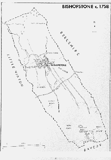
Bishopstone c.1758
Bishopstone grew up north of the Swindon–Wantage road where the two coombs converge. A stream, called Westbrook in 1773, (fn. 14) rises in the west coomb and flows northwards across the lowland to the Cole: it is joined from the west by another springing north of the Swindon– Wantage road. Between the two the church, manor house, and demesne farmstead of Bishopstone manor were built, and the mill was built north of the road on the eastern stream with its pond south of the road where it remains a prominent feature. The village developed in an arc around that nucleus. It was a community of many small farmsteads, closely grouped, and linked with the Swindon–Wantage road by a network of lanes. (fn. 15) The copyholders held more land on the east side of the parish than the west, and their farmsteads were more numerous in the east part of the village, especially beside the lane, leading north to the lowland, which was called High Street in 1758. The open space near the mill in the centre of the village was then called Hocker Bench. (fn. 16) The village was apparently wealthy in the Middle Ages: the assessment for taxation in 1334 was above average and in 1377 the number of poll-tax payers, 169, was very high. (fn. 17) Taxation assessments in the 16th century were also high. (fn. 18) Apparently in the 18th century the village spilled over to the south side of the Swindon-Wantage road. East of the mill pond a line of cottages was then built on the waste in an arc in the west coomb, and along a short path west of the pond a few more cottages were built. (fn. 19) In the 19th century several more cottages and houses were built in those areas, and the school was also built beside the mill pond. In the 20th century several houses, including the present vicarage house and in 1977 a village hall, (fn. 20) have also been erected south of the road. As the number of farms in the parish decreased the population fell by a third between 1881 and 1901. (fn. 21) Not many farmhouses and cottages in the northern and eastern parts of the village were demolished, but the balance of the village was then being shifted by the demolition of the old manor house and by the building of two large red-brick houses, Forest House and Eastbrook Farm, (fn. 22) and most new houses and cottages beside the Swindon-Wantage road and at the east end of the village. In 1801 the population was 530. By 1851 it had risen to a peak of 755 and by 1901 had declined to 404. It was 449 in 1911 and 371 in 1934 when figures for Bishopstone alone are last available. (fn. 23) More than half of the 569 inhabitants of the enlarged parish lived in Bishopstone in 1971. (fn. 24)
In 1980 the older buildings were scattered about the lanes north of the Swindon-Wantage road and concentrated in the west coomb. The predominant building materials before the 20th century were chalk, often used with red-brick quoins and window surrounds, and thatch. Manor Farm beside the Swindon-Wantage road at the west end of the village has a long 17thcentury range and a later wing to the east, and there is another 17th-century farmhouse behind it. Another 17th-century farmhouse survives north-east of the church and there are some 15–20 cottages and small houses apparently of 17th- and 18th-century origin in High Street and the parallel lane west of it. The True Heart in High Street was open in the earlier 19th century and rebuilt c. 1900: the Royal Oak in the lane west of High Street was built in 1907 on the front of an 18th-century building. (fn. 25) South of the Swindon– Wantage road some 18th-century cottages and a variety of 19th-century houses and cottages survive. In the mid 20th century the balance of the village has shifted back to its northern and eastern parts, where there are few 19th-century dwellings, with the building of various private houses and some 30 council houses. There has been little settlement in the parish outside the village. Russley Park was built on the downs c. 1700 (fn. 26) and several houses stood there in 1980. Starveall Farm, a pair of cottages and farm buildings of chalk with brick dressings erected in the early 19th century, and Ridgeway Farm, buildings and a pair of cottages of the late 19th century, are also on the downs, and two farmsteads have been built on the lowland in the 19th and 20th centuries.
Manors and Other Estate.
It has been plausibly suggested that in 1086 the bishop of Salisbury's Ramsbury estate included Bishopstone, not itself named in Domesday Book, (fn. 27) and early ownership by the bishops is implied by the place name: (fn. 28) the earliest express record of an episcopal estate there was in 1208. (fn. 29) In 1294 the bishop was granted free warren in his demesne lands. (fn. 30) The manor of BISHOPSTONE passed with the see of Salisbury until the Civil War. In 1647 it was sold to John Oldfield and Matthew Kendrick, apparently trustees or agents of the lessee Gilbert Keate. (fn. 31) The manor was returned to the see at the Restoration. (fn. 32) It passed in 1869 to the Ecclesiastical Commissioners, later the Church Commissioners, owners in 1980. (fn. 33)
In the early 16th century the bishops leased their demesne lands to members of the Precy family and in 1542 Bishop Salcot granted a lease of them until 1605 to John Precy. (fn. 34) In 1548 the bishop leased the whole manor, subject to the Precys' interest, to John Knight for 99 years. (fn. 35) Knight was possibly a trustee of the Precys. Charles Precy held the manor from 1600 or earlier until his death in 1626. (fn. 36) It passed to Thomas Precy and Henry Shelley, possibly his executors. In 1626–7 they sold the lease to Gilbert Keate (d. 1657–8) to whom new leases were granted in 1629 and 1636. (fn. 37) Gilbert was succeeded by his son Jonathan (created a baronet in 1660) to whom a new lease was granted in 1661. (fn. 38) Keate assigned his lease in 1663–4 to Christopher Willoughby (d. 1681) and it passed to Christopher's cousin George Willoughby (knighted in 1686, d. 1695). (fn. 39) In 1692–3 Willoughby settled his leaseholds of the manor and prebend of Bishopstone and new leases were granted to his trustees. (fn. 40) They passed together to his son Christopher (d. 1715), to Christopher's son George (d. 1751), and to George's son Henry. (fn. 41) In 1757 the lease of Bishopstone manor was sold after proceedings in Chancery to a trustee of the paymaster-general, Henry Fox (created Baron Holland in 1763, d. 1774), (fn. 42) and was apparently settled on Fox's son Stephen (d. 1774). (fn. 43) The lease passed with the Holland title to Stephen's son Henry Richard (from 1800 Henry Richard Vassall) Fox (d. 1840) and grandson Henry Edward Fox (d. 1859), (fn. 44) whose relict Mary sold it to the Ecclesiastical Commissioners in 1862. (fn. 45)
In 1647 there was on the manor a ten-room house, built of and roofed with stone, with thatched outbuildings. (fn. 46) It stood south-west of the church, between the church and the Swindon-Wantage road, and was lived in by the Willoughbys. (fn. 47) In 1757 it was settled for life on Jane, relict of George Willoughby (d. 1751). (fn. 48) From 1803 it was held by James Puzey (d. 1837) who kept a school in it. (fn. 49) In 1840 the house was said to be large, dilapidated, and only partly occupied. Drawings of it made in 1845 show it to have been in a mixture of styles. Wings were taken down in 1852. In 1862 the house was taken into the prebendal estate by the Ecclesiastical Commissioners in exchange for land, and was demolished. (fn. 50)
The manor of BISHOPSTONE PREBEND was presumably taken from Bishopstone manor by a bishop of Salisbury to endow the prebend of Bishopstone, (fn. 51) and, consisting of tithes and demesne and customary land, it belonged to the prebendaries until the Civil War. In 1651 the lands were sold to Gilbert Keate. (fn. 52) They presumably passed to Sir Jonathan Keate but at the Restoration were given back to the prebendary. (fn. 53) Land was allotted to replace the tithes in 1813. (fn. 54) The last prebendary died in 1838. The income from the manor was paid to Queen Anne's Bounty until in 1840 the manor and the profits from 1838 were vested in the Ecclesiastical Commissioners. (fn. 55) The land was part of the Church Commissioners' Bishopstone estate in 1980. (fn. 56)
In 1538 and 1573 prebendaries leased their manor to Thomas Davy. (fn. 57) In 1584 a new lease was granted to a trustee of the Davy family, members of which took the profits until at least 1620. (fn. 58) In 1633 John Barnstone, the prebendary, leased the prebend to William Barnstone for lives which possibly survived the Interregnum. (fn. 59) In 1672 the prebend was leased to Christopher Willoughby, and new leases were granted to the lessees of Bishopstone manor until in 1751 and 1755 they were granted to Jane, relict of George Willoughby (d. 1751). (fn. 60) By 1780 Henry Richard Fox, Lord Holland, had become lessee. (fn. 61) In 1784 the prebendal manor was leased to John Hepworth, rector of Grafham (Hunts., later Cambs.), (fn. 62) and in 1813 a lease was held by the executors of William Church of Upper Upham in Aldbourne. (fn. 63) From 1820 to 1855 Richard Webb (d. 1837) and his executors were lessees. (fn. 64)
There was a house on the manor in 1341 and 1631. (fn. 65) In 1758 the house stood north-west of the church. (fn. 66) In 1862–3 the Ecclesiastical Commissioners built on the estate a new red-brick house, Forest House, later Prebendal Farm, between the site of the demolished Bishopstone manor house and the Swindon-Wantage road. The house north-west of the church was demolished between 1884 and 1922. (fn. 67)
A sporting estate was established on Russley down as part of Bishopstone manor, possibly by the Willoughbys in the late 17th century or the early 18th. In 1758 there was a house with a main block of five bays and a symmetrical front of two storeys with attics and a basement. It lay near the centre of a partly hedged and partly paled park of 119 a. in which avenues ran south, east, and west. (fn. 68) The house was lived in by Henry Willoughby and passed with the lease of Bishopstone manor to the Foxes. (fn. 69) Russely park was sublet with sporting rights over the whole parish, from 1771 to William Craven, Lord Craven (d. 1791), who owned the neighbouring Ashdown Park in Ashbury (Berks., later Oxon.). It was held until his death in 1825 by Lord Craven's son William, Lord Craven, who from c. 1803 further sublet it. (fn. 70) In 1826 Lord Holland sublet the Russley estate to Thomas Hedges of Highworth and in 1864 the sublessee was J. Challoner Smith. (fn. 71) In 1870 the Ecclesiastical Commissioners sold the estate to Thomas Challoner Smith, and in 1899 it seems to have belonged to Henry Challoner Smith. (fn. 72) About then the old house was demolished and a new one built on its site. The estate belonged to racehorse trainers. In 1907 W. T. Robinson of Foxhill in Wanborough sold it to W. Hall Walker who sold it in 1916 to the Secretary of State for War as agent for the Board of Agriculture. (fn. 73) A large farm and stable complex was erected south-east of the house, initially for use as a stud farm. (fn. 74) In 1931 the War Department sold it to Thomas Oakley. (fn. 75)
Economic History.
From the 13th century or earlier Bishopstone was divided between the bishop of Salisbury's and the prebendary's manors, (fn. 76) and from the later Middle Ages two areas of cultivation, Eastbrook and Westbrook, were distinguished. (fn. 77) Each manor included land in each area of cultivation. There are references to Eastbrook and Westbrook in 1425, and in the early 17th century the words were used freely to locate holdings. (fn. 78) The division may have originated in the position of farmsteads on either side of the stream rising in the west coomb. The pastures at each end of the parish were outside them and by the later 18th century the origins of, and the line between, the Eastbrook and Westbrook divisions had become obscure. (fn. 79)
Although the number and extent of the arable fields in the Middle Ages is not clear, the existence of a biennially sown south field in 1425 suggests a simple two-field system. (fn. 80) A much more fragmented arrangement in the mid 17th century is evident but the practice of leaving half fallow again suggests a two-field origin. (fn. 81) The bishop's manor was larger than the prebendary's and in 1291 three times as valuable. (fn. 82) The bishop's demesne farm was apparently in hand in the 13th century and was not leased until after 1438. (fn. 83) The manor was independent of the bishop's manor of Ramsbury, but exchanges of stock and produce were made among the demesnes of Bishopstone, Ramsbury, and Baydon. (fn. 84) The fact that in 1286 it was recorded that 43 oxen customarily passed from bishop to bishop indicates much arable cultivation at some time. (fn. 85) There were 201 a., 603 selions, of demesne land sown in 1425; 82 a. of meadow land were mown; and at Michaelmas there were flocks of 379 wethers and 311 ewes. (fn. 86) In 1438 there were 171 a. sown and 652 sheep kept. (fn. 87) The customary works owed by the tenants may have been sufficient to cultivate the demesne, but by the earlier 15th century they had been commuted and the demesne was largely cultivated by wage labour. In 1425 the customary holdings, for which rents totalled £17 5s., seem to have been small and numerous: they included 35 of 1 yardland and 19 of ½ yardland. (fn. 88) In 1508 the rent for the demesne lands was £18; in 1535 customary rents were £22. (fn. 89) A demesne warren was referred to in 1542. (fn. 90) The most valuable part of the prebendary's manor was presumably the tithes of grain, hay, and sheep which in the Middle Ages were due from the whole parish. (fn. 91) In 1341 the demesne land included an arable carucate, meadow land, and several pasture for 100 sheep and 14 cattle. (fn. 92) Rents amounting to £1 12s. were paid by the customary tenants, of whom there were eight holding a total of 8 yardlands in 1405. The prebendal estate was then held by lease. (fn. 93) It was valued at £19 9s. in 1535. (fn. 94) There were 41 a. of demesne in 1631. (fn. 95)
About 1647–9 there were c. 50 farmsteads with small areas of pasture in the village and 1,750 a. of arable land in the centre of the parish. North of that all the meadows and pasture on the lowland seem to have been used in common for part, if not all, of the year. South of it most of the upland pastures, including Russley, 250 a., for cattle, were likewise common. The demesne farm of Bishopstone manor, 750–800 a., was in the west half of the parish. The copyholders of the manor held 70 yardlands, 1,450 a., of which more than 50 were in Eastbrook. There were 42 tenants and only one holding clearly over 100 a.: nine holdings exceeded 50 a. Each yardland had feeding rights for 30 sheep, 2 horses, and 3 beasts. The copyholds included 125 a. of 'lanes', pastures of some 1–10 a. scattered among the arable furlongs. Lammy Down, 42 a. north of the Ridge Way, was later a several part of the episcopal demesne. The prebendal tithes were worth £140 in 1649. The demesne of the prebendal manor measured 33 a. and the ten prebendal copyholders held 8 yardlands in Eastbrook and 1 yardland in Westbrook with feeding rights similar to those of the episcopal copyholders. (fn. 96)
Common husbandry in Bishopstone was in general altered little in the 18th century although it was constantly being refined and amended in detail. (fn. 97) Before 1758, however, 120 a. of Russley down was inclosed and made into a sporting estate. (fn. 98) The remaining downs were divided between Farm down, 400 a., and Town down, 240 a. for the episcopal and prebendal copyholders. Bishopstone common, 350 a., at the north-east corner of the parish was only for the episcopal copyholders. The meadows and pastures at the north-west corner, 200 a., were apparently a several part of the demesne farm of Bishopstone manor, Bishopstone farm. Between the upland and lowland pasture the arable land was in 1758 in 163 furlongs, characteristically divided into ½-a. strips, totalling some 2,000 a. The Bishopstone farm arable land, 430 a., was in complete furlongs in Westbrook but apparently commonable. The farm, with buildings west of the manor house in the village, had been sublet by the Willoughbys until taken in hand, and badly managed, by Henry Willoughby after 1751. There were 40 other farmsteads in the village and only a downland barn outside it. The prebend was sublet for £145 a year and at least some of the tithes further sublet to the occupiers of the land. (fn. 99)
In 1784, when the parish measured 3,520 a., there were 1,725 a. of arable land, over 700 a. of meadow and lowland pasture, and over 800 a. of upland pasture and down. Of the arable land 441 a. were sown with wheat, 254 a. with barley, 125 a. with oats, 344 a. with peas, beans, and vetches, and 49 a. with clover and ryegrass; 512 a. were fallow. Bishopstone farm measured 955 a., Russley park 120 a., the prebendal demesne 42 a., and the vicar's glebe 16 a. The 69½ copyhold yardlands of Bishopstone manor amounted to 1,401 a., the 9 of the prebendal manor 145 a. There were 600 a. in Bishopstone common and Town down. The 78½ copyhold yardlands were held by a total of 45 tenants and there were no more than 22 occupiers of the land, some of them, including William Phillips who occupied over 330 a., holding entirely as undertenants. There were several farms over 100 a., the majority were 30–100 a., and a few were under 30 a. (fn. 100)
It seems likely that in the 18th century the number of farms fell and that their sizes increased, (fn. 101) but the amount of subletting makes that impossible to prove. In the 19th century, however, the concentration of the land into a few large farms can be clearly seen. The commonable lands, all the arable land and Town down and Bishopstone common, were inclosed and allotted in 1813 under an Act. At the same time all the prebendal and vicarial tithes were exchanged for land and there were various exchanges of land. (fn. 102) Bishopstone (later Manor) farm remained a long narrow strip on the west side of the parish, 840 a. in 1840. (fn. 103) From 1813 to 1901 members of the Dore family occupied it. (fn. 104) In 1840 it had additional buildings on the lowland and in 1864 more on Farm down. (fn. 105) The prebendary was allotted 640 a. in narrow strips north and south of the village immediately east of Bishopstone farm. Prebendal farm was worked from the prebendal manor house and buildings beside the Ridge Way until 1862–3 when new buildings were erected on the site of Bishopstone manor house. (fn. 106) The vicar's glebe was worked as a farm, 133 a., in the late 19th century and early 20th. (fn. 107) The eastern side of the parish was occupied by 17 inclosed copyhold farms over 20 a., including one over 200 a. and four over 100 a., and by 33 smallholdings, but the number of separately worked farms is uncertain. (fn. 108) In 1864 over 1,000 a. of the 1,600 a. of copyhold land was in four holdings. Between 1865 and 1880 the Ecclesiastical Commissioners took in hand most of the copyholds and by 1883 had merged much of them into Eastbrook farm, 981 a., with a newly erected house and enlarged farm buildings at the east end of the village. Over 200 a. of Bishopstone common were leased to a farmer in another parish and some 233 a. remained copyhold. (fn. 109) In the 19th century and early 20th Starveall and Ridgeway were smaller upland farms, (fn. 110) but since the Second World War there have been only three principal farms in the parish, Manor, Prebendal, and Eastbrook, of which Manor and Prebendal have sometimes been held together. (fn. 111) In 1980, when the farming in the parish was mixed, they measured respectively 836 a., 961 a., and 1,338 a. (fn. 112) Watercress was cultivated in beds north and south of Bishopstone mill from 1878 or earlier until the 1930s or later. (fn. 113) There have been occasional references to clothworking in Bishopstone and in 1927 hemp was said to be produced commercially. (fn. 114)
Russley park was enlarged to 245 a. in 1882 when its owner acquired the southernmost part of Town down. (fn. 115) In 1895 its owner was training racehorses on Bishopstone downs by arrangement with the farmers, and stables were established at Russley. In 1904 gallops on the downs for a maximum of 80 horses were leased to the owners of the stables at Foxhill. The gallops continued to be used from Foxhill until c. 1950. Because they prevented inclosure and thus anything but inconvenient sheep grazing they were then abandoned in order to improve the farms. (fn. 116)
Mills. There was a mill at Bishopstone in the mid 13th century, apparently four in the mid 14th, and two on the demesne of Bishopstone manor in the early 15th. (fn. 117) A mill remained part of that manor. (fn. 118) The mill buildings near the centre of the village were said in 1788 to house two water grist mills. (fn. 119) The mill was rebuilt by the lessee Peter Knight in 1818. (fn. 120) In 1864 it was said to house three pairs of stones and in 1886 was a flour mill. (fn. 121) Milling was apparently stopped between 1903 and 1907. (fn. 122)
Local Government.
The bishops of Salisbury's right to exercise royal jurisdiction in Bishopstone came from their rights in Ramsbury hundred, (fn. 123) and it is not clear whether separate views of frankpledge were held for Bishopstone in the Middle Ages. The right to hold courts was leased with Bishopstone manor from 1548 and it was later made clear that public jurisdiction was over the whole parish. (fn. 124) In the 17th century the lessees held an annual view of frankpledge but, especially from the 1620s, it dealt with little more than the election of constables and tithingmen. The court baron of Bishopstone manor was held in autumn on the day of the view, and additional courts were sometimes held. Much copyhold and agrarian business was done: overseers of the commons, 'leazelookers', and other officers were appointed. (fn. 125) Since common husbandry and copyhold tenure lasted long at Bishopstone those matters remained the main business of the courts in the 18th century. (fn. 126) The court baron of the prebendal manor was held occasionally in the late 17th century and the 18th. The proceedings of fifteen courts held between 1663 and 1753 were separately recorded and those of others were recorded with those of Bishopstone manor courts. The courts dealt only with copyhold business. (fn. 127) In the mid 18th century the lessee of the two manors merged the courts, but they were again separate in the late 18th century. Both were held for copyhold business and little else in the 19th century. (fn. 128)
Annual expenditure on the poor was £153 in 1775–6 and £240 in 1802–3 when 14 adults were relieved regularly and 55 occasionally. (fn. 129) The parish, which had no workhouse, spent an average of £520 a year on the poor 1833–5, a figure not abnormal for the size of parish. Bishopstone joined Highworth and Swindon poor-law union in 1835. (fn. 130) In the early 19th century there were two surveyors of highways who, for their purposes, divided the parish into east and west tithings. (fn. 131)
Church.
Bishopstone church was standing in the 12th century. (fn. 132) By analogy with Bishopstone in Downton hundred it may first have been served from Ramsbury, but was later a parish church. (fn. 133) The church's revenues were assigned to endow a prebend in Salisbury cathedral, possibly before 1226 and certainly before 1291. (fn. 134) The parish became a prebendal peculiar: prebendaries held visitation courts and administered the ecclesiastical affairs of the parish until the death of the last prebendary in 1838. (fn. 135) A vicarage had been ordained by 1305. (fn. 136) The parish was transferred to Gloucester and Bristol diocese in 1837 and has been in Bristol diocese since 1897. (fn. 137) In 1946 the benefices and ecclesiastical parishes of Little Hinton and Bishopstone were united. (fn. 138)
The advowson of the vicarage belonged to the prebendary. (fn. 139) For reasons that are not clear the bishop of Winchester presented in 1348 and the queen in 1582. In 1667 Christopher Willoughby presented by grant of a turn. (fn. 140) In 1840 the advowson was transferred by Act to the bishop of Gloucester and Bristol and in 1897 to the bishop of Bristol, the patron in 1980. (fn. 141)
The vicar's income in 1535 included an annuity of 4 marks from the prebendary, said to have been long paid. (fn. 142) The living was valued at only £20 c. 1620 when the prebendary's lessee was accused of failing to pay the annuity. (fn. 143) The poverty of the living led to an augmentation of tithes by John Barnstone, prebendary 1601–43, but in 1649 the vicarage was still said to be worth no more than £30. (fn. 144) A state augmentation of £15 13s. 4d. was given and taken away before 1655. (fn. 145) After the Restoration Barnstone's augmentation was continued and Henry Kinnimond, prebendary 1660–78, gave a further £12 a year from the prebend. (fn. 146) In 1716 Thomas Coker, prebendary 1696–1741, increased the pensions from the prebend to the vicars by £15 6s. 8d. to £30, (fn. 147) and that sum was paid until the lease of the prebend was surrendered to the Ecclesiastical Commissioners in 1855. (fn. 148) The vicar's annual income of £208 in the period 1829–31 was nevertheless still below average. (fn. 149)
The vicar had all lesser tithes in 1405. (fn. 150) Barnstone assigned to the vicars tithes of corn, hay, wool, and lambs from the 9 copyhold yardlands of the prebendal manor. (fn. 151) In the 1780s the vicar was also said to have the tithes of Bishopstone common. (fn. 152) In 1631 the vicar's glebe was a yardland of 21 a. without common feeding rights on Town down. (fn. 153) In 1813 the vicar was allotted 136 a. to replace his tithes and glebe. (fn. 154) In the 1880s and 1890s the vicar tried unsuccessfully to sell the land to the Ecclesiastical Commissioners and in 1904 was himself forced to buy the buildings necessary for it to be worked as a farm. The Ecclesiastical Commissioners bought those buildings as an endowment for the vicarage in 1917, but in 1920 bought the whole glebe. (fn. 155) There was a glebe house in 1582. (fn. 156) A new house with four rooms on each floor was built a little north of the churchyard in 1721. (fn. 157) Part of it was rebuilt in 1873. (fn. 158) In 1880 the Ecclesiastical Commissioners gave to the vicar by exchange land between the vicarage house and the churchyard, and on the enlarged site a new vicarage house was built. (fn. 159) That house was sold in 1969 when the vicar moved to a house built c. 1947 on the south side of the Swindon-Wantage road near the east end of the village. (fn. 160)
As might be expected from the poverty of the living there were few notable vicars. John Wilson, vicar from 1626, was deprived before 1650. (fn. 161) The living was held by a succession of ministers 1649–59 until Wilson (d. c. 1667) was restored in 1660. (fn. 162) In 1737 Thomas Coker was prebendary, a younger Thomas Coker was vicar, and Henry Coker was curate. (fn. 163) In 1783 Nowes Lloyd was incumbent of both Little Hinton and Bishopstone: his assistant curate lived at Bishopstone and held services alternately in the two parishes. (fn. 164) Whittington Landon, dean of Exeter, became vicar in 1817, prebendary in 1822. He presented his son J. W. R. Landon to succeed him as vicar in 1825, and the son remained non-resident vicar until his death in 1880. (fn. 165) On Census Sunday in 1851 there were congregations of 90 at the morning and 130 at the afternoon services, above average for Bishopstone but small for a parish as populous. (fn. 166) In 1680 Christopher Willoughby gave £2 a year to the vicars for preaching two sermons and 10s. a year for keeping a register for his other charities. In 1896 the sermon charity was separated from the other Willoughby charities. (fn. 167) It was still being paid in 1980. (fn. 168)
The church of ST. MARY, so called by 1405, (fn. 169) is of coursed sarsen and has a chancel, an aisled nave with incorporated north porch, and a west tower. A fragment of an 11th- or 12thcentury string course set high on the west wall of the chancel is probably in situ: other remains of the 12th-century church are the reset north doorway of the chancel, (fn. 170) carved fragments above the south doorway of the nave, and the font. (fn. 171) The outer arch of the porch is of the later 12th century and was apparently reset when the porch was built in the early 14th century. The east window of the south aisle and some of its painted glass are also of the 14th century. The tower was built in the 15th century, by which time the church seems to have reached its full extent. The arcades and most of the outer walls of the aisles and chancel were rebuilt in the late 15th century or the early 16th. The church was restored in 1882, when the west gallery was removed, under the direction of Ewan Christian, and again restored in 1891 after a serious fire in the tower. (fn. 172) In 1680 Christopher Willoughby gave £1 a year for bell ringing. (fn. 173) By will proved 1796 Thomas Goddard gave £300 in trust for ringing and preserving the bells, or for beautifying or repairing the church. In the 19th century the charity provided substantial sums to maintain and improve the church fabric. By 1867–9, however, £466 had been accumulated. The income of £14, from which the ringers received £2, was spent. (fn. 174) In 1980 at least part of the income was still used for bell ringing. (fn. 175)
The church had a chalice and paten in 1405. (fn. 176) A chalice of 6 oz. was left for the parish in 1553 when 2 oz. of silver were taken for the king. It was replaced by a chalice dated 1627, a flagon hallmarked 1634 given in 1719, a paten hallmarked 1719, and an almsbowl hallmarked 1761. (fn. 177) In 1553 there were three bells and a sanctus bell. (fn. 178) There was a peal of eight in 1794. (fn. 179) The oldest was said to be dated 1602. (fn. 180) In 1891 the bells, including three of 1796 cast by Robert and James Wells of Aldbourne and given under his will by Thomas Goddard, were destroyed by fire. A new peal of eight was cast in that year by Mears & Stainbank, the tenor from the fragments of the old bells. (fn. 181)
The registers date from 1573: entries for the period 1573–93 are transcripts, those for 1594– 1602 are missing. (fn. 182)
Nonconformity.
A parishioner was presented in 1624 for failing to receive Holy Communion. (fn. 183) It is likely that several houses in Bishopstone were licensed for nonconformist worship in the early 19th century, (fn. 184) and in 1829 there was a congregation of Independents in the parish. (fn. 185) A chapel for Primitive Methodists was opened in the south-east part of the village in 1833. (fn. 186) It was said to hold a congregation of 130 and to be full at the evening service on Census Sunday in 1851. (fn. 187) It was replaced by a chapel at the south end of High Street in 1886. (fn. 188) That chapel was closed c. 1970. (fn. 189)
Education.
By will dated 1703 Thomas Goddard of Lockeridge in Overton gave some of his books to the school at Bishopstone. (fn. 190) By deed of 1778 Thomas Coker gave 5 a. at Purton, subject to a rent charge of 30s. for Little Hinton school, and £200 for a school for poor children at Bishopstone, and by will proved 1796 Thomas Goddard gave £600 for a similar purpose. (fn. 191) From c. 1803 to c. 1840 the school was held in the manor house, which was leased to the schoolmaster. (fn. 192) In 1818, when there was another boarding and day school, the charity school was open to all poor children of the parish and attended by nearly 40. (fn. 193) Attendance had risen to 83 by 1833 when there were 65 charity pupils. (fn. 194) The school was then held by the master and an assistant. Coker's charity kept eighteen children there and Goddard's provided £4 10s. for books and £23 10s. for the master. (fn. 195) It had been resolved in 1821 not to distinguish Coker's and Goddard's pupils (fn. 196) and in 1834 they were being taught together; the remaining pupils were taught at the opposite end of the large schoolroom. (fn. 197) In 1849 the school was in a two-room cottage, but in 1850 a new National school was completed on a site beside the mill pond. (fn. 198) Attendance in 1859 was c. 70, (fn. 199) and the school was enlarged in 1872. (fn. 200) Numbers fell steadily from 83 in 1908 to 51 in 1938 although from 1920 the older children of Little Hinton were sent to Bishopstone. (fn. 201) In 1980 there were 31 children on roll. (fn. 202)
By an invalid will dated 1867 Christopher Edmonds intended to give £100 to the school. After his death his family gave the money to the Sunday school. (fn. 203) In 1872 the school received £50 from Coker's and Goddard's charities and in 1960 £52 from all three charities. (fn. 204) Income was still received in 1980. (fn. 205)
Charities for the Poor.
By will proved 1658 Gilbert Keate gave £600 to the Grocers Company of London for life pensions of £4 a year to four old people of Bishopstone. (fn. 206) Pensioners were chosen in 1665 but, because much of the company's property was destroyed in the Great Fire of London, payments were not made until c. 1680. In 1706 the company compounded for the arrears for the period 1665–80 in £150, £100 of which was invested and used for extraordinary relief in cash or kind. (fn. 207) In 1903 there were only women pensioners. (fn. 208) In 1680 Christopher Willoughby gave the great tithes of Clench in Milton Lilbourne for various charitable purposes, including two life pensions of £3 10s. a year to poor parishioners of Bishopstone and four similar pensions from the residue of the charity's income. (fn. 209) The pensions of £3 10s. were paid to women; the four variable, and usually more valuable, pensions were paid to men. Payments were suspended 1814–21 because of a dispute among the trustees. In 1900 the men's pensions were each of £7 2s. (fn. 210) By will dated 1819 Stephen Goddard gave the income from £200 as a life pension to a poor widow or widower. (fn. 211) In the 19th century successive pensioners received c. £5 a year. (fn. 212)
A copyhold stone quarry in Bourton (Berks., later Oxon.) was held for the poor of Bishopstone before 1658, presumably to provide stone for building in Bishopstone. Stone was sold to the G.W.R. c. 1840 for £213 which was invested. The quarry was later leased to inhabitants of Bourton, c. 1903 for £5 14s. a year. (fn. 213) At inclosure in 1813 the poor of Bishopstone were allotted 1 a. for clothing or fuel to replace their right to cut furze on lands then inclosed. The land, called the Forty Gardens, was let as allotments, some of which were built on. In 1903 there were seven cottages on the land and rents yielded £8 10s. The Bourton quarry and Forty Gardens charities were then used to buy coal for some 60 people. (fn. 214)
The five Bishopstone eleemosynary charities were united by a Scheme in 1931. The incomes from Keate's, Willoughby's, and Goddard's were used to form a pension fund. In 1960 pensions of 4s. a week were paid to each of five parishioners. The incomes from the Bourton quarry and Forty Gardens charities were used for the general benefit of the poor. Percy James Stone (d. 1972) gave by will £5,835 to the united charities. (fn. 215) In 1980 pensions were still given. (fn. 216)