A History of the County of Wiltshire: Volume 14, Malmesbury Hundred. Originally published by Victoria County History, London, 1991.
This free content was digitised by double rekeying. All rights reserved.
A P Baggs, Jane Freeman, Janet H Stevenson, 'Introduction', in A History of the County of Wiltshire: Volume 14, Malmesbury Hundred, ed. D A Crowley (London, 1991), British History Online https://www.british-history.ac.uk/vch/wilts/vol14/pp1-4 [accessed 30 April 2025].
A P Baggs, Jane Freeman, Janet H Stevenson, 'Introduction', in A History of the County of Wiltshire: Volume 14, Malmesbury Hundred. Edited by D A Crowley (London, 1991), British History Online, accessed April 30, 2025, https://www.british-history.ac.uk/vch/wilts/vol14/pp1-4.
A P Baggs, Jane Freeman, Janet H Stevenson. "Introduction". A History of the County of Wiltshire: Volume 14, Malmesbury Hundred. Ed. D A Crowley (London, 1991), British History Online. Web. 30 April 2025. https://www.british-history.ac.uk/vch/wilts/vol14/pp1-4.
INTRODUCTION
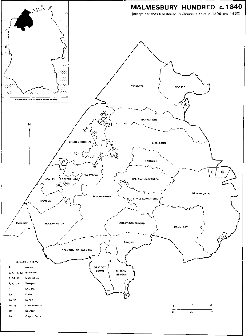
Malmesbury hundred in north-west Wiltshire is flat, well drained land, not an area of hill forts and henge monuments, but one of dense and apparently prosperous settlement in the Saxon period. Malmesbury was the site of an early and wealthy abbey around which a town grew up, and the place names, including Norton, Sutton, Somerford, Stanton, Crudwell, and the evocative Charlton, are typically Saxon. At the Conquest Malmesbury was as developed as any town in Wiltshire, and the two hundreds which later merged as Malmesbury hundred probably contained as many villages to the square mile as any other in the county. Malmesbury stands on a promontory above the Sherston and Tetbury branches of the Bristol Avon; Oaksey and Brinkworth are sited on ridges, but nearly all the other villages are beside streams. Many are mentioned in Malmesbury abbey charters but the boundaries ascribed to them may be much later than the purported dates of the charters: nevertheless some boundaries, notably the Foss Way and other roads, and the Avon, its Sherston branch, and its tributaries Gauze, Brinkworth, and Woodbridge brooks, are clearly ancient and suggest an early end to intercommoning by villages. A straight line dividing several pairs of parishes in the south part of the hundred suggests a later end to it there, and isolated examples of intercommoning persisted throughout the Middle Ages.
Most of the hundred is in Wiltshire's Cotswold country where Cornbrash and limestone and clay of the Forest Marble outcrop: to the south-east, where the clay soils are heavier, part is in the Cheese country. The Cotswold country was noted for sheep-and-corn husbandry, and nearly every principal village in the hundred is known to have had open fields and common pastures in the Middle Ages. There was apparently little dispersed settlement before the 16th century and the villages remained small. Malmesbury, a focus for many of them, never had a market to rival Tetbury, Cirencester, or Chippenham, and the success of its cloth industry was spasmodic. Although the town expanded westwards in the 19th and 20th centuries the two branches of the Avon prevented expansion in the other three directions, and, poorly served by railways and modern roads, it has remained commercially undeveloped. In the 20th century a few of the villages, Hullavington, Brinkworth, and Sutton Benger, have grown substantially; there has been new building in most of the others, perhaps encouraged by the proximity of the M4 motorway and fast rail services, but a few, including Norton, Foxley, Draycot Cerne, and Garsdon, have remained very small. At various times some hamlets have dwindled to single farmsteads, but the hundred is not an area of lost villages.
The land was inclosed mainly in the 16th and 17th centuries, especially, it seems, in the early and mid 17th century. For some small groups of open fields, like those of Foxley, Dauntsey, and Brinkworth, there is little evidence of inclosure. Where there is evidence of a large group, as for Brokenborough, Charlton, and Hullavington, the fields can be seen to have been inclosed at first piecemeal, afterwards in stages by agreed inclosures over a long period, in some places preceded, in others followed, by inclosure of common pasture. Only at Crudwell and Stanton St. Quintin was inclosure of open arable by Act. After inclosure much land was laid to grass, and in the later 19th century and early 20th there was dairy farming throughout the hundred. Since 1939 much of the land has again been ploughed. Common meadow land at Seagry was not inclosed until 1883, and in many places vestiges of common pasture in wide lanes and on small greens remain visible.
There was in the hundred a lack of woodland consistent with early settlement and early division of the land, but most villages preserved small areas of ancient woodland: in the south-west, for example, Corston, Rodbourne, Hullavington, Surrendell, Bradfield, Norton, Foxley, and Bremilham all had 10–20 a. Villages further north or east may have taken wood from the purlieus of Braydon forest. The forest itself was reduced to an area east of the hundred in 1300, but until the 1630s both the forest and its purlieus, parts of which were called Minety or Charlton quarter and Brinkworth quarter, remained open for feeding in common by cattle from villages with land adjoining them. Soon after 1630, when the forest was inclosed, each village with a valid claim to such pasture rights was allotted a specified part of the purlieus: in Malmesbury hundred Oaksey, Crudwell, Hankerton, Cloatley, Brokenborough, Charlton, Milbourne, Garsdon, Lea, Cleverton, Little Somerford, and Brinkworth received allotments, those for Brinkworth, Charlton, and Hankerton being the largest. Over most of the allotments the land was inclosed and improved and new farmsteads were built, but some parts were assigned as common pasture and remained such until the early 19th century. Some allotments adjoined the land of the villages for which they were made and were parts of the relevant parishes; others, detached, were either absorbed by surrounding parishes or transferred to them statutorily in the 19th century.
In several parishes Malmesbury abbey had large demesne buildings, some of which were erected or repaired in a building boom of the later 13th century, but only two large medieval barns, at Brokenborough and Crudwell, survive. In Malmesbury and generally throughout the hundred the few medieval domestic buildings which survive are largely hidden by later alterations: Abbey House in Malmesbury is over a 13th century undercroft, a farmhouse at Sutton Benger contains the remains of a 13th century chapel, Dauntsey House has an early 14th-century hall range, and Garsdon Manor includes a 14th-century cruck roof. Many farmhouses were rebuilt in the 17th century, and in many villages gabled houses of stone with stone-slated roofs and mullioned windows are a prominent feature: to the south-east, where there was less stone and more woodland, there are timber-framed houses of that date. In the 17th and 18th centuries, after inclosure, more farmsteads were built outside the villages. Rebuilding continued in the 19th century, but there are fewer 19th-century planned farmsteads on new sites than elsewhere in the county, presumably because around Malmesbury the farms, mostly devoted to dairying, remained small. In the later 20th century Malmesbury was limited as a commercial centre, and the villages around it, in many of which farming activities had ceased, offered little employment. Where the land was worked from outside the village, farm buildings were either converted for residence or replaced by new housing.
Malmesbury abbey owned c. 23,000 a. of the hundred, besides more outside it, but few of its records survive and no detailed account of the estate can be given. There was nothing to rival it after the Dissolution, but the Howards, earls of Suffolk and of Berkshire, held four of the abbey's manors, c. 10,000 a. after the increases of the 1630s, and later more, and theirs was the grandest mansion in the hundred. Their house, built for Sir Henry Knyvett, an energetic Elizabethan squire keen to promote local military organization, was embraced in the early 17th century by Charlton Park which has stylistic similarity to Audley End. The Longs and their descendants the earls of Mornington and the Earls Cowley owned Draycot Cerne for over 450 years and built up an estate around it with large houses at Draycot and Seagry. The estate of the Dauntsey and Danvers families, which may have originated soon after the Conquest and included Malmesbury borough after the Dissolution, disintegrated after c. 1650. In the 18th and 19th centuries large estates were held by the Foxes, Lords Holland, and the Bouveries, earls of Radnor, but most estates were small and the manor houses not much more than farmhouses. Malmesbury, among the most rotten of boroughs, was usually represented in parliament by local men, and only in the later 18th century were the seats disputed by the Howards and Foxes.
The division of the hundred into parishes and the arrangements for churches to be served, as complex as elsewhere in Wiltshire, were presumably much influenced by Malmesbury abbey which took the great tithes from most of its estates. Even in an area of many villages some parishes on its estates were large, taking in several villages and hamlets; the churches on two, Brokenborough and Charlton, were dependent on St. Mary's church in Malmesbury's suburb Westport, and those on two more, Hankerton and Lea, were for long dependent chapels. Away from the abbey's estates, however, the parishes, such as Bremilham, Foxley, and Seagry, were small. The abbey church became the parish church of Malmesbury after the Dissolution, elsewhere much medieval work survives in the churches, and there is a Saxon church in Westport. Local incumbents included two enthusiastic providers of garden allotments for the poor, and at Stanton St. Quintin, Bertrand Pleydell-Bouverie, a son of the earl of Radnor, carved a fine stone pulpit for the church. Quakerism was strong, various dissenting groups, including Moravians, established themselves in Malmesbury and Westport, and in the earlier 19th century Brinkworth was the centre from which southern England was evangelized by Primitive Methodists.
MALMESBURY HUNDRED c.184O
(except parishes transferred to Gloucestershire in 1 896 and 1 930)