A History of the County of Wiltshire: Volume 14, Malmesbury Hundred. Originally published by Victoria County History, London, 1991.
This free content was digitised by double rekeying. All rights reserved.
A P Baggs, Jane Freeman, Janet H Stevenson, 'Parishes: Westport', in A History of the County of Wiltshire: Volume 14, Malmesbury Hundred, ed. D A Crowley (London, 1991), British History Online https://www.british-history.ac.uk/vch/wilts/vol14/pp229-240 [accessed 30 April 2025].
A P Baggs, Jane Freeman, Janet H Stevenson, 'Parishes: Westport', in A History of the County of Wiltshire: Volume 14, Malmesbury Hundred. Edited by D A Crowley (London, 1991), British History Online, accessed April 30, 2025, https://www.british-history.ac.uk/vch/wilts/vol14/pp229-240.
A P Baggs, Jane Freeman, Janet H Stevenson. "Parishes: Westport". A History of the County of Wiltshire: Volume 14, Malmesbury Hundred. Ed. D A Crowley (London, 1991), British History Online. Web. 30 April 2025. https://www.british-history.ac.uk/vch/wilts/vol14/pp229-240.
In this section
WESTPORT.
Westport was a separate settlement linked to Malmesbury by a short stretch of road along a narrow ridge and, as its name implies, it lay outside the west gate of Malmesbury. (fn. 1) It had a church in the late Saxon period, and later both Brokenborough and Charlton churches were dependent on Westport church. (fn. 2) Nearly all the land around the town of Malmesbury belonged to Malmesbury abbey, possibly from soon after its foundation in the 7th century, and, perhaps before the Conquest when St. Paul's church in Malmesbury may have been standing, (fn. 3) the abbey assigned some of the land to Westport church as a parish. Apart from Brokenborough and Charlton, the parish had an irregular shape almost like a figure 8 with the church and main settlement in the centre: it comprised land north, west, and south-west of the town and included the hamlets or farmsteads called Filands and Thornhill and possibly a hamlet called Walcot. (fn. 4) As a suburb of Malmesbury, part of the settlement called Westport was within the boundary of Malmesbury borough. The land owned by the borough, in the early 17th century called King's Heath, was added to Westport parish and extended the parish south-westwards: most of King's Heath, the south-west part, was later called Malmesbury common. (fn. 5) In 1840 the parish was 2,036 a. (824 ha.). For reasons suggested elsewhere much of the parish boundary was irregular and six small areas, mainly embraced by Malmesbury and Brokenborough parishes, were detached. (fn. 6) The Westport parish boundary followed a tributary of the Sherston branch of the Bristol Avon south of Malmesbury, both the Sherston Avon and the Tetbury branch of the Avon west of Malmesbury, and short stretches of road in several places. For a short distance the boundary was the town wall of Malmesbury. For most of its length, however, the parish boundary was not marked by prominent features, and to the west that with Brokenborough through Hyam park was defined only in 1838. (fn. 7)
Parts of Malmesbury common, a total of 16 a. belonging to the lord of Foxley manor and the rector of Foxley, were claimed by both Westport and Foxley c. 1840 (fn. 8) and were in Foxley in 1885. Between 1840 and 1884 c. 13 a. in various fields north and north-west of the town were transferred from Westport to Brokenborough. Between 1882 and 1884 one of the detached areas of Westport was transferred to Brokenborough and five were transferred to Malmesbury, small exchanges were made between Westport and Malmesbury, and a detached part of Bremilham parish, 8 a. near the town, was transferred to Westport. (fn. 9) Most of the settlement was assigned to Malmesbury urban sanitary district when it was created in 1872 and was included in Malmesbury municipal borough in 1886. (fn. 10) The remainder of the parish, 1,961 a. (794 ha.), was added to St. Paul Malmesbury Without parish in 1896. In 1894 the Westport part of the municipal borough became the civil parish of Westport St. Mary Within. It absorbed the civil parish of Brokenborough Within in 1897 and thereafter measured 91 a. (37 ha.). (fn. 11) In 1934 it was merged with the other civil parishes of the borough to form a new Malmesbury parish. Lands west and north of the town and formerly in Westport parish were added to Malmesbury in 1984. (fn. 12)
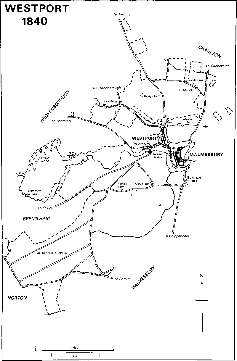
Westport 1840
Kellaways Clay outcrops over most of the former parish, especially in the south-west where Malmesbury common is flat and mostly below 80 m. Higher land lies at 91 m. in the north-east, where two areas of Oxford Clay outcrop, and in the west. Much of those areas of the parish was for long pasture. Both branches of the Avon and the south-east boundary stream have exposed terraces of Cornbrash and strips of clay of the Forest Marble: the Cornbrash favours tillage and limestone has been taken from quarries through the clay. Sand and gravel have been deposited in a small area near the northern boundary. The only steep slope in the parish is in the centre where the land rises from the rivers to the town wall. In the west Hyam wood, east of which was a park, was the only woodland. (fn. 13)
Two main roads from Malmesbury crossed Westport parish, that north to Tetbury (Glos.) and Gloucester and that west to Bristol via Sherston. Both were turnpiked in 1756. (fn. 14) Only a short stretch of the Sherston road, in the suburb of Westport, lay within the parish; it ran along part of the parish boundary further west, as did the Malmesbury—Cirencester road north-east of the town. The Tetbury road was disturnpiked in 1874, the Sherston road in 1876. (fn. 15) From the Sherston road a road ran north to Brokenborough, crossing the Tetbury Avon by Back bridge, apparently so called in 1478. (fn. 16) The settlements of Westport and Brokenborough were linked by a road which apparently forded the Tetbury Avon c. 500 m. north-west of the west gate: (fn. 17) by 1820 a new stretch of road had been made on the south bank and joined the road over Back bridge. (fn. 18) A road through Filands in use in 1773 carried much of the Chippenham-Tetbury traffic after an eastern bypass was built around Malmesbury in 1973. (fn. 19)
Before the Sherston road was turnpiked the main Malmesbury—Bristol road, part of an Oxford-Bristol road in the later 17th century, led through the south part of the parish towards Foxley: near Westport it crossed the Sherston Avon by a bridge, known in the Middle Ages as Turketyl and later as Westport bridge, and 400 m. south-west of the bridge a road diverged to Malmesbury common and Corston. (fn. 20) Both roads were in use in the late 20th century, when that to Corston was called Common Road. Lanes between Common Road and Burton Hill in Malmesbury, in use in the late 18th century, were not public roads in the late 20th. Others, across Malmesbury common, were replaced in 1832 by straight tracks, running north-east and south-west, (fn. 21) which were still in use in 1989.
The suburb of Westport was the main settlement in the parish. Filands and Thornhill, hamlets in the Middle Ages, had each dwindled to one or two farmsteads by the late 18th century. (fn. 22) In 1801 the population of the parish was 702. It had risen to 1,023 by 1821 and continued to rise, with some fluctuations, until 1881, when it was 1,867. Although land and houses in Bremilham were added to Westport in the 1880s others were lost to Brokenborough, and by 1891, the last date for which a figure for the whole parish is available, the population had dropped to 1,669. (fn. 23)
Settlement had presumably extended from Malmesbury into the suburb of Westport by the late Saxon period. (fn. 24) Westport, so called in 1135, (fn. 25) is at the town's north-western corner and linked to it along the ridge by Abbey Row. Buildings on the west side of the town along lanes called Burnivale and King's Wall, between the town walls and the Sherston Avon, were also in Westport parish. In the 19th century the suburb comprised approximately a third of the borough's total area. (fn. 26) A guildhall stood in Westport c. 1200 (fn. 27) and from the later 13th century until the 16th the parts of the borough in the two parishes were distinguished as Westport and Bynport. (fn. 28)
Most buildings of Westport were in King's Wall and Burnivale, in Abbey Row, in the Sherston and Tetbury roads leading respectively west and north from Abbey Row, and in the angle between the roads. In the late Saxon period the church was north of the Sherston road near what was until the 19th century the western edge of the settlement. (fn. 29) By the later 12th century the parish church had been built west of the Tetbury road, there later called Gloucester Road. (fn. 30) An open space south of the church, known from the 19th century as the Triangle, and another north-west of the church, called Horsefair from the 17th century, were presumably market places. A market for Malmesbury to be held in Westport was granted in 1252 and later markets and fairs were apparently held there. (fn. 31) From Horsefair a lane, called Milk Street in the late 18th century (fn. 32) and later West Street, ran south to the Sherston road, there called Bristol Street. Another, called St. Mary's Street, linked Horsefair to the Triangle. West Street and the Triangle were linked by Katifer Lane. In the late 17th century the buildings of Westport were probably clustered around those streets. (fn. 33) Early building in Burnivale and King's Wall included a chapel (fn. 34) and Postern Mill. (fn. 35)
Probably in 1643, when there were both royalist and parliamentary attacks on Malmesbury, Westport suffered considerable damage, including the destruction of the parish church. Later 17th century buildings to survive include the Three Cups in the Triangle and several cottages in Horsefair and Gloucester Road. In King's Wall a large house was built c. 1700, (fn. 36) and no. 22 Horsefair bears the date 1703. In the late 18th century lanes, later called Foundry Road and Harper's Lane, led respectively north from Horsefair to Gloucester Road and south-west from Bristol Street towards Westport bridge. By then settlement had spread north in Gloucester Road to Staines bridge and west in Bristol Street to the fork of the Foxley and Sherston roads. (fn. 37) In the late 18th century and the early 19th much of Westport was rebuilt. (fn. 38) A nonconformist chapel was built in Horsefair in 1788 (fn. 39) and a double-fronted house of three storeys north of Abbey Row bears the date 1798, but most new building was of terraces of two-storeyed cottages with fronts of stone rubble. (fn. 40) A medieval range of building west of the church in St. Mary's Street, standing in 1809, (fn. 41) was apparently replaced soon afterwards. The increase in the population of Westport parish in the early 19th century (fn. 42) presumably resulted from new building in the suburb. There were c. 300 houses there in 1831; (fn. 43) most were apparently small, and in the 1840s it was reported that only one was occupied by a member of the professional classes. (fn. 44)
Another increase in population in the 1860s was ascribed to the sale of land and the building of new houses. (fn. 45) Some may have been built in Gastons Road, leading north from Bristol Street, where there were already a few houses in 1845, (fn. 46) and some in Burnham Road, which linked Gastons Road and Horsefair. Commercial and institutional building also took place in the later 19th century. A chapel was built in Bristol Street in 1856, a foundry was opened in Foundry Road c. 1870, and warehouses at the northern end of Gloucester Road and a hotel near Staines bridge may have been built in the 1870s. (fn. 47) Two large houses, Stainesbridge House and Verona House, were built near the bridge in 1871 and 1883 respectively, (fn. 48) and Euclid Villas, a pair of very tall Gothic houses south of Abbey Row, are of similar date. Cottages were replaced by new terraces in Bristol Street, where Avon Terrace bears the date 1888, and St. Mary's Street, where Mansfield Terrace bears the date 1899. In 1881 the population of the part of Westport which lay within Malmesbury urban sanitary district was 1,711; only 156 people lived elsewhere in the parish. (fn. 49)
In the mid 20th century most new building on the west side of Malmesbury was local authority housing in what had been Brokenborough parish. Within the former Westport parish a scattering of residential and industrial buildings grew up beside the Tetbury road, north of Staines bridge where it was called Tetbury Hill, and on the north side of Park Road west of Staines bridge. Two large estates of private houses were built, White Lion Park south-west of Park Road in the 1960s and Reed's Farm east of Tetbury Hill in the 1980s. A garage and light industrial and commercial buildings replaced earlier buildings north of Staines bridge in the 1970s and 1980s.
In 1620 four alehousekeepers were recorded in Westport. (fn. 50) One may have kept the Weaver's Arms, mentioned in 1666. (fn. 51) The Three Cups and the Castle, both in the Triangle, were open in 1822; (fn. 52) the Castle was closed after 1956, (fn. 53) the Three Cups was open in 1989. The Suffolk Arms, east of Tetbury Hill, was open in 1875 and 1989. The Bath Arms in Horsefair, the Railway hotel near Staines bridge, and the Plough beside the Sherston road, were opened between 1875 and 1885. (fn. 54) The Bath Arms was closed after 1956. (fn. 55) The Railway hotel, renamed the Flying Monk, was closed in the 1960s (fn. 56) and demolished c. 1980. (fn. 57) The Plough was closed in 1970. (fn. 58)
Thomas Hobbes (1588–1679), the philosopher, was born in a house near Westport church and received his schooling in Westport and Malmesbury. His father Thomas served Brokenborough church as curate in the early 17th century but lived at Westport: John Aubrey called him 'an ignorant Sir John' and wrongly described him as vicar of Westport. (fn. 59)
Filands was probably a hamlet in the late 13th century. (fn. 60) It had 17 poll-tax payers in 1377. (fn. 61) Orchard Farm, north of the road through the hamlet, is of 17th-century origin, and in 1773 the hamlet consisted of that and another farmstead east of it. (fn. 62) Filands Farm was built west of Orchard Farm in Malmesbury parish in the early 19th century, and between 1840 and 1885 a brickworks was built further west. (fn. 63) Two houses were built near the Cirencester road in the early 20th century, in the 1930s four pairs of houses were built between Filands Farm and the brickworks, and in the later 20th century the brickworks was replaced by a new farmstead called White Lodge Farm. In 1964 a school was built south-west of White Lodge Farm. (fn. 64)
Thornhill, also apparently a hamlet in the 13th century, (fn. 65) had 12 poll-tax payers in 1377, (fn. 66) and in the Middle Ages Malmesbury abbey had a grange called Thornhill. (fn. 67) The farmstead called Archars Farm in 1773 (fn. 68) may mark the site of Thornhill. It was rebuilt c. 1800 and renamed Thornhill Farm. By 1820 a new Arches Farm had been built east of it, (fn. 69) and cottages were built south-west of it beside Common Road in the late 19th century and the early 20th. Halcombe House, a substantial later 19th-century house, was built before 1885 north-east of Thornhill Farm near the junction of the Foxley road and Common Road, (fn. 70) and in the later 20th century houses and bungalows were built near the junction and along the north side of the Foxley road.
By 1538 a lodge had been built for the keeper of Hyam wood: (fn. 71) it was probably on the site of Hyam Park near the boundary between Westport and Brokenborough. Elsewhere in the parish, Bremilham Mill and a farmhouse called Back Bridge were standing in 1773 (fn. 72) and survived in 1989. Between 1820 and 1840 a new Backbridge Farm was built north-east of, and cottages were built south of, Back bridge. (fn. 73) A 'smallpox house' stood west of Thornhill Farm apparently in Westport parish in 1773, (fn. 74) a fever (isolation) hospital near Back bridge was in use from the 1890s to 1933, and a cemetery for Westport and Malmesbury parishes was opened west of Tetbury Hill in 1884. (fn. 75)
Manors and other Estates.
The lands which became Westport parish, like those which became Malmesbury parish, are likely to have been held by Malmesbury abbey from or soon after its foundation in the 7th century. (fn. 76) They belonged to the abbey in the early Middle Ages, when they were recorded as part of a large estate called Brokenborough, (fn. 77) and the abbey kept them until the Dissolution. (fn. 78)
In 1547 the Crown granted lands south-west of Malmesbury as THORNHILL manor to Sir William Herbert (fn. 79) (cr. earl of Pembroke 1551). (fn. 80) By 1551 the estate had passed, presumably by sale, to William Stumpe (d. 1552), who settled it on his wife Catherine for life. Catherine later married William Basely and died in 1556. Thornhill passed to her son William Stumpe, (fn. 81) who sold it in 1576 to William Grymer. (fn. 82) In 1582 Grymer sold it to John Snell (d. 1587) and Snell's son Thomas, (fn. 83) who was later knighted. Sir Thomas (d. 1612) was succeeded by his son Sir Charles, who, probably c. 1617 and according to John Aubrey to raise money to provide a ship for Sir Walter Raleigh's last expedition, sold Thornhill to John Langton. In 1625 Langton settled the manor on his son John. By will dated 1660 the younger John's son John may have devised it with Easton Piercy manor in Kington St. Michael to his wife Elizabeth and sister Joan Lewis for 80 years. Either by inheritance or, with Easton Piercy, by release from Elizabeth and Joan, Thornhill passed to John's brother Sir Thomas Langton (d. c. 1672), who was succeeded in turn by his sons Thomas (d. c. 1696) and Robert. (fn. 84) In 1704 Robert sold the manor to Thomas Howard, earl of Berkshire (d. 1706). (fn. 85) It was conveyed by Joan Billers to William Robins and his wife Anne in 1758, (fn. 86) and by George Spackman to John Smith and his wife Elizabeth in 1767. (fn. 87) In 1788 the Smiths conveyed it to John Neate. (fn. 88) In 1827 it was apparently sold by Stephen Neate, and in 1839 Richard Blackford and Mary Garlick held Thornhill farm, 185 a. The farm was sold in 1869, (fn. 89) probably to C. W. Miles (d. 1892). It presumably passed with Miles's Burton Hill House estate in Malmesbury to C. N. Miles and A. C. Miles and was sold in 1919 by T. A. G. Miles. In 1921 Jesse Wootton sold the farm, 173 a. (fn. 90) R. S. Smith owned it in 1927 and 1931. (fn. 91) G. W. Sisum, the owner in 1939, sold the farm c. 1945. As a farm of 100 a. it was bought in 1962 by J. Neate and in 1969 by Mr. D.J. Grange, the owner in 1989. (fn. 92)
In the later 18th century there was a farm south-west of Malmesbury called ARCHARS. (fn. 93) At the Dissolution it is likely to have been granted by the Crown with Burton Hill manor in Malmesbury, which in 1577 was broken up by Adam Archard and Thomas Hall. (fn. 94) About 1800, when the farmstead was rebuilt and renamed Thornhill Farm, (fn. 95) it apparently belonged to the owner of Thornhill manor. In 1839 Arches farm, 100 a., belonged to Josiah Hanks. (fn. 96) With Thornhill farm it belonged to C. N. Miles in 1910, when it measured c. 150 a., (fn. 97) and it was presumably sold like Thornhill farm in 1919. In 1927 Arches farm belonged to H. L. Storey (fn. 98) (d. 1933). Like Burton Hill House it was bought by the Shaftesbury Society, which sold it in 1948 to Percy Webb (d. 1985). Webb's sons Mr. Allen Webb and Mr. Roy Webb owned the farm, 180 a., in 1989. (fn. 99)
After the Dissolution Malmesbury abbey's land called HYAM, later Hyam park and Hyam farm, was part of Brokenborough manor. The manor was granted in 1552 to John Dudley, duke of Northumberland, who sold it in 1553 to Sir James Stumpe. It passed to Sir Henry Knyvett and in the Howard family with the earldoms of Suffolk and Berkshire. (fn. 100) In 1839 Hyam farm included c. 240 a. in Westport parish. (fn. 101) It was sold by an earl of Suffolk after 1912, (fn. 102) and was bought in 1927 by T. L. Horn, who sold it in 1939 to his sister-in-law Ursula and her husband G. G. Cox Cox. In 1988 Mrs. Cox Cox owned Hyam farm which then included c. 150 a. of the former parish of Westport. (fn. 103) Hyam Park was built in the 17th century as a long north—south range with a main east front. In the 18th century a short west wing was added at the south end to make a new symmetrical south front, in 1922 a west wing was added at the north end, and in 1927 the south wing and south front were extended and other alterations were made to the house. Also in the 1920s a large cattle yard west of the house, bounded on the west by a stone barn probably of the 18th century, was made into gardens. Extensive 20th-century farm buildings are further west.
An estate called FILANDS was held in 1183–4 and in 1195 by Walter Mautravers (d. before 1201), presumably by knight service of Malmesbury abbey; it passed to his brother John (d. 1220), (fn. 104) and by 1248 may have reverted to the abbey. (fn. 105) In 1535 the abbey held lands in Westport formerly Mautravers's, (fn. 106) but after the Dissolution no separate estate was called Filands.
The land of Filands is likely to have been granted after the Dissolution as part of Whitchurch and Milbourne manor in Malmesbury, which included land in the north-east part of Westport parish. In 1782 William and Thomas Robins conveyed 42 a., formerly part of that manor, to John Jefferies, who devised them to Jane Coles. In 1820 she sold the land to Thomas Howard, Viscount Andover, later earl of Suffolk and of Berkshire, (fn. 107) and it was reunited with Whitchurch and Milbourne manor. Much of that manor descended with the Suffolk title and in 1989 belonged to Michael Howard, earl of Suffolk and of Berkshire, (fn. 108) but it is not clear whether the 42 a. were part of it. Another part of Whitchurch and Milbourne manor apparently passed with Whitchurch farm to Richard Kinneir, who in 1839 held 116 a. in Westport. That land passed with the farm to members of the Elwell family (fn. 109) who held 76 a. in Westport in 1927, (fn. 110) and to Mr. Edward Weaver, owner of Whychurch farm in 1989. (fn. 111)
In the Middle Ages the Crown held Malmesbury borough, including the part in Westport parish, and from 1215 to the Dissolution Malmesbury abbey held it in fee farm. The Westport part of the borough and the land adjoining it was from 1628 part of Malmesbury manor, sometimes called Malmesbury and Westport manor. (fn. 112) In 1839 the manor, then held by the Revd. George RushoutBowles, included c. 35 a. in Westport. (fn. 113) The lands passed to Elizabeth, Baroness Northwick (d. 1912), who in 1896 sold the reversion in lots. (fn. 114)
Malmesbury borough, which enjoyed certain privileges in or before the 11th century, may also have held lands; more land may have been granted by Malmesbury abbey after it became fee farmer of the borough in 1215, (fn. 115) and in the mid 13th century the guild merchant of Malmesbury received heath land south-west of the town from the abbey in an exchange. (fn. 116) The borough charter of 1381 ascribed a grant of 5 hides of heath near Norton, south-west of the town, to King Athelstan: (fn. 117) the charter clearly indicates that in 1381 the borough owned KING'S HEATH, but the claim that it had been given by Athelstan is implausible. In 1839 Malmesbury corporation owned Malmesbury common, 522 a., and c. 200 a. east and north-east of it. (fn. 118) In 1989 the burgesses and freemen of Malmesbury held a total of 718 a., of which c. 670 a. had been in Westport parish. (fn. 119)
In the 13th century Robert of Lea held 1 hide, apparently what later became BACKBRIDGE farm but then said to be in Thornhill. (fn. 120) The land probably passed with Lea manor in Lea and Cleverton parish until the later 16th century and with Boakley farm in Brokenborough until the early 19th. (fn. 121) In 1340 Sir John Mauduit and his wife Agnes conveyed 88 a. in Thornhill with Lea manor to their son-in-law John Moleyns. (fn. 122) The estate passed to Moleyns's son Sir William (d. 1381), who held it in 1370, (fn. 123) and probably thereafter in the Moleyns and Hungerford families and to members of the Hastings family, earls of Huntingdon. An earl of Huntingdon held an estate in Westport in the mid 16th century, part of which was sold in 1571 with Boakley farm by Henry Hastings, earl of Huntingdon, to Anthony Webb and in 1593 by Webb to William Bailey. (fn. 124) At his death in 1621 William held lands in Westport, (fn. 125) presumably the c. 130 a. held by his great-grandson Anthony Bailey (fl. 1655). As at Boakley farm, later owners were Giles Bailey, Daniel Bennett, Daniel's son Giles, and Giles Bailey Bennett. In 1822 Daniel's grandson Daniel Bennett sold Backbridge farm to Thomas Howard, earl of Suffolk and of Berkshire. (fn. 126) It passed with the earldoms to Henry, earl of Suffolk and of Berkshire, who owned the farm, 106 a., in 1912. (fn. 127) By 1927 it had been sold, (fn. 128) and it later had several different owners.
A small estate including Bremilham Mill passed with lands in Foxley from Thomas Bremilham to his son John, to John's son Richard (d. c. 1557), and to Richard's grandnephew Thomas Nicholas and great-grandnephew Robert Shipton. Thereafter it apparently passed with Player's farm in Foxley to Henry Vassall, Baron Holland, (fn. 129) who in 1839 held c. 70 a. and the mill in Westport parish. (fn. 130) The estate passed with Foxley manor to Maj. A. R. Turnor whose son Mr. R. W. C. Turnor owned the mill and 54 a. in 1989. (fn. 131)
Humphrey Bridges (d. 1598) and his son Humphrey held jointly an estate in Westport and adjacent parishes. (fn. 132) At the younger Humphrey's death in 1609 it comprised c. 100 a. and rights of common pasture. He was succeeded by his brother Anthony (fn. 133) (d. 1617), whose heirs were his sisters Elizabeth, wife of Robert Bridges, Margaret, wife of John Breath, and Jane, wife of Richard Stevens, and his nephew Anthony Bridges. (fn. 134) The later history of the estate has not been traced.
The endowment of a chantry, founded in Westport church by 1478, (fn. 135) included c. 70 a. in Westport. (fn. 136) In 1564 the lands were conveyed by Henry Knyvett and his wife Elizabeth to Matthew King. (fn. 137) In 1569 they were successfully claimed by Thomas Estcourt, (fn. 138) who in 1571 sold them to John Stumpe (fn. 139) (d. 1600). Stumpe was succeeded by his son James, who at his death in 1602 held c. 140 a. in Westport and other parishes and was succeeded by his son William. (fn. 140) No later record of the Westport part of that estate has been found.
Rents from Westport were given to Bradenstoke priory by Henry le Bret in 1232 and by Andrew son of John of Malmesbury in the later 13th century, and in the mid 13th century the priory held other land there. (fn. 141) In 1535 the priory received rents totalling 13s. 4d. from Westport. (fn. 142)
Malmesbury abbey was licensed to appropriate Westport church between 1159 and 1181; the licence was apparently confirmed in 1191. (fn. 143) Thereafter the abbey owned the RECTORY estate until the Dissolution, (fn. 144) and afterwards most rectorial tithes probably passed with the estates from which they were derived. In the later 16th century rectorial tithes from Thornhill were apparently leased by the Crown with those from Corston. (fn. 145) The lessees claimed payment of tithes from the owners of Thornhill manor, apparently unsuccessfully. (fn. 146) Some tithes from Thornhill did, however, pass with those from Corston to R. H. Gaby. (fn. 147) In 1839 Gaby owned great tithes from 143 a. in Westport, the earl of Suffolk and of Berkshire those from 89 a., the vicar of Malmesbury those from 68 a., and the rector of Bremilham those from 10 a.: the tithes were all commuted in 1840. King's Heath was tithe free, and tithes from most other lands in the parish were merged. (fn. 148)
Economic History.
Apart from King's Heath, which is treated separately below, nearly all the agricultural land of the parish was worked by Malmesbury abbey and its tenants in the Middle Ages. North of the town inhabitants of Filands may have shared lands with those of Whitchurch, as south of it those of Thornhill may have done with those of Burton Hill. To the west the abbey had woods and possibly parkland called Hyam in demesne.
In the late 13th century the abbey had 14 tenants at Filands and c. 12 at Thornhill; all were presumably customary tenants. Of those at Thornhill, one held 60 a., probably arable in open fields, four others had similar or greater holdings, (fn. 149) and all presumably had rights to common pasture. In the late 15th century the abbey had a grange at Thornhill and held demesne land there, apparently in hand. The land may have been mainly pasture on which the abbey kept sheep and cattle to supply its own larder. (fn. 150) In the 1530s the demesne, including arable in the open fields and c. 50 a. of several pasture and meadow, was leased, perhaps as a single holding. (fn. 151) In 1539–40 seven tenants shared 18 yardlands; another held 30 a. of arable and the grange. Works of cutting and gathering hay in meadows in Westport and Malmesbury parishes had been commuted, (fn. 152) probably much earlier. Woodland and a warren at Hyam were leased separately in 1538. (fn. 153) In 1340 Sir John Mauduit's 88 a. were shared by 5 tenants; the largest holding was of 60 a. of arable and 3 a. of meadow. (fn. 154) Of Westport chantry's c. 70 a., a single tenant held 63 a. in the open fields in 1548. (fn. 155)
In the mid 16th century c. 40 a. of Westport parish north of Malmesbury were part of Whitchurch marsh, a common pasture presumably used mainly by the men of Whitchurch. South of Malmesbury, Kemboro field, partly in Malmesbury parish, was worked by tenants of both Burton Hill and Thornhill manors. Thornhill manor also included Quarry field, south of the Sherston branch of the Avon, and Brokenborough field, perhaps north of the river. Its common pasture, part of Awls or Alice heath, was probably to the south beside the parish boundary. Between the mid 16th century and the 19th both arable and pasture were inclosed, apparently piecemeal, and the number of farms was reduced. The Thornhill part of Alice heath had been inclosed by the mid 16th century (fn. 156) and the latest reference to open-field cultivation in Westport dates from 1628. (fn. 157) Except for part of King's Heath, lands in the north half of the parish may have been the last to be inclosed. The Westport part of Whitchurch marsh was not mentioned when the Malmesbury part was inclosed in 1792 under an Act of 1790 and had almost certainly been inclosed earlier. (fn. 158) Common pasture or open field between the suburb of Westport and Brokenborough village is likely to have been inclosed long before 1822 when lands of Backbridge farm were called new inclosures. (fn. 159) The land of Hyam, which may have been a park in the Middle Ages, is known to have been one in the 16th century, (fn. 160) and in 1649 comprised 201 a. in Westport and Brokenborough parishes. (fn. 161) The park had been extended to c. 400 a., half in each parish, by c. 1785. (fn. 162)
In the early 19th century most of the parish was worked in small farms with a high proportion of pasture. In 1839 c. 750 a. were in farms of c. 70 a. or more. Hyam farm, 441 a. including 201 a. in Westport, was worked from the farmstead on the boundary of Brokenborough and Westport, and 116 a. in the north of the parish were worked from Whitchurch Farm in Malmesbury with lands in that parish. Thornhill farm was 160 a., Arches and Backbridge farms were each c. 100 a., and the farm attached to Bremilham Mill was 69 a. Of the remaining lands, c. 700 a. were in farms of 20–50 a. each and some were in smaller farms. Most of the farms of less than 50 a. had land near Malmesbury and were presumably worked as smallholdings from within the town or the suburb of Westport. Hyam wood was then 40 a. (fn. 163)
The pattern of farming in the parish had apparently changed little by the early 20th century. A market garden on 6 a. beside Tetbury Hill in 1910 (fn. 164) had expanded to occupy 11 a. by 1927. (fn. 165) In the 1930s most of the agricultural land of the former parish was still pasture although some south of the town was arable. (fn. 166) In the 1980s sheep and beef cattle were reared on Hyam farm, Arches was an intensive dairy farm, and the lands of Thornhill farm were permanent pasture; (fn. 167) factories were built on part of Backbridge farm.
In the south-west part of the parish the names of Cooks heath, Portmans heath, Alice heath, and Great heath suggest that most of the land was pasture, but in the mid 13th century Cooks heath and other lands were cultivated. Except for part of Alice heath, which was used by the men of Thornhill, from the mid 13th century nearly all that land belonged to the borough of Malmesbury: (fn. 168) it was later called King's Heath, and from the 18th century the low lying and badly drained south-west part of it was called Malmesbury common. (fn. 169) There is no evidence that either pasture or arable was inclosed in the Middle Ages. In the late 14th century rights to feed animals on and to cultivate the land apparently belonged to members of the guild merchant of Malmesbury and to members of other privileged groups in the borough, but the details of how they used the land are obscure. (fn. 170) By c. 1570 lands near the town had been inclosed and allotted, c. 1570 Cooks heath was similarly dealt with, (fn. 171) and in 1607 there were c. 100 a. in closes. (fn. 172) By 1610 more closes had been allotted (fn. 173) but most of the land was still subject to common grazing rights. In the early 19th century c. 210 a. were several and holdings varied from 1 a. to 15 a. (fn. 174) Closes were frequently broken in the late 16th century and the early 17th: (fn. 175) it is not clear how far the objection was to inclosure and how far the result of disputes about how the borough should be governed. (fn. 176)
Use of King's Heath was regulated by the borough court. Orders were made in 1620 for stinting on Hundred hill, and in the 1650s forbidding commoners to feed cattle not their own on the common pasture. In 1686 regulations for marking beasts and cutting gorse were issued and in 1691 it was agreed that winter grazing on the common pasture should be leased to the highest bidder. In 1669 a fine imposed on a capital burgess for ploughing his close was remitted because the change of use was to the general good. Under the terms of the borough charter of 1685 the alderman and 12 capital burgesses granted their closes on 21-year leases. The lessees improved the land by burnbaking and presumably brought them into cultivation and, when the leases were revoked under a charter restored in 1690, claimed compensation for the sums spent on improvement. In 1714 the borough court ruled that it was lawful for any close to be ploughed and sown providing it had been burned; there was to be a rotation of three crops, with clover sown in the fourth year. (fn. 177)
In 1760 and presumably earlier inhabitants of Foxley parish had the right to feed cattle on a small area of Malmesbury common near Foxley village. (fn. 178) In the early 19th century the common, described as a deplorable scene of waste and desolation, was overgrown with furze and gorse and so badly drained that it was impassable in bad weather. (fn. 179) Under an Act of 1821 c. 500 a. were inclosed and drained in 1832. All but 20 a. were allotted either to Malmesbury corporation, presumably to be added to the holdings of those who already had some inclosed land, or to the trustees of King's Heath, who were drawn from the corporation and regulated the commoners' lands. The allotments to the corporation and trustees were divided into 280 holdings of between 1 a. and 3 a. each. The remainder was allotted to neighbouring landowners who had grazing rights on the common, including 15 a. to Henry Vassall, Baron Holland, lord of Foxley manor. (fn. 180) Thereafter part of what was still known as Malmesbury common was cultivated. In 1886 only 30 a. were pasture; the main crops were wheat, grown on 82 a., and potatoes, grown on 126 a. Stubble was still grazed in common, and 150–200 pigs were usually kept on the allotments between 1886 and 1906. By 1930, however, much of the land had passed out of use. Few commoners took up their rights to cultivate land themselves and much of the common was managed by the trustees, who let part of it to neighbouring farmers. During the Second World War the common was again drained and part was again ploughed. (fn. 181) In 1989 both Malmesbury common and the older inclosures, c. 700 a. in all, were let to neighbouring farmers. (fn. 182)
Mills.
In the 13th century Robert of Lea held a mill in Westport. (fn. 183) Postern Mill on the river below King's Wall was on a site used for a mill from the 12th century or the 13th. (fn. 184)
Bremilham Mill was probably standing in the 1550s and may have been on the site of a much earlier mill. (fn. 185) In the later 19th century it was apparently the site of a considerable business, but milling ceased there between 1885 and 1899. In 1925 the wheel raised water for domestic use. (fn. 186) The mill and its outbuildings were demolished after 1945. (fn. 187) The mill house, a 17th-century stone building of one storey with attics, was standing in 1989, and the mill wheel was in situ. Another mill in the parish may have stood near Back bridge. (fn. 188)
Trade and industry.
Stone quarrying and iron working may have taken place on the site of Postern Mill in the late Saxon period and there may have been a tannery near the mill in the later Middle Ages. (fn. 189) A tanner lived in Westport in 1729 (fn. 190) and others are recorded there later in the 18th century. (fn. 191) A tanyard near Back bridge in 1798 (fn. 192) was probably that between Park Road and the Sherston road in use in 1823 and 1839. (fn. 193) From 1865 the yard was held by members of the Thompson family who until the 1880s had another at the Light, the detached part of Bremilham parish south of the Sherston road. Tanning ceased in Westport between 1895 and 1899. (fn. 194)
In the mid 18th century shafts were sunk on Malmesbury common in the hope of finding coal. Only lignite was found (fn. 195) but mining rights on the common were still leased in 1812. (fn. 196) In 1885 and 1912 there was a brickworks west of Filands; it had closed by 1919. On the western edge of the suburb several quarries were opened after 1885 but were mostly disused in 1924. (fn. 197) What was said to be a quarry on Malmesbury common in the 1920s (fn. 198) was perhaps a clay pit.
Some businesses associated with the town of Malmesbury were carried on from premises in Westport, and new factories west of Tetbury Mill and small industrial units in Park Road were built in the 1980s. (fn. 199)
Local Government.
The part of Westport in Malmesbury borough was subject to the borough courts, which also regulated King's Heath. Courts held for Malmesbury manor also had jurisdiction in the parish, chiefly over the suburb of Westport. In the earlier 18th century two constables for Westport were appointed at the borough sessions, and in the later 18th century two constables and two sidesmen were appointed at the manor court. (fn. 200)
Malmesbury abbey apparently held separate courts for Thornhill in the earlier 16th century. (fn. 201) No record of courts for Thornhill manor has been found.
In 1636 Malmesbury and Westport parishes disputed responsibility for relief of the poor living within the precinct of Malmesbury abbey. Westport was found to be responsible for those living in seven houses, (fn. 202) and a small part of the suburb was in Abbey parish which relieved its own poor in the later 18th century and the earlier 19th. (fn. 203) In 1648 Westport petitioned to set its own rates as other parishes did, giving as a reason the damage which had been suffered by the parish in military action and from the billeting of soldiers there. The petition may have been prompted by some alteration in the method of assessment following the garrisoning of Malmesbury in 1644; apparently before 1648 and certainly afterwards the parish set its own rates. (fn. 204)
In 1775–6 poor relief in Westport cost £125. Expenditure was £452 in 1802 when 53 adults and 90 children received permanent and 25 people occasional relief. The cost and numbers relieved were then approximately half those of Malmesbury parish. In 1813 permanent relief was given to 75 adults and occasional relief to 32; the total cost was £782. Expenditure was lower in the 1820s, (fn. 205) and between 1833 and 1835 the average annual cost was £408. In 1835 Westport became part of Malmesbury poor-law union. (fn. 206) In the late 18th century a building in Burnivale, which may have been St. Mary's chapel, was said to have long been used as a poorhouse. (fn. 207)
Church.
The church at Westport before the Conquest (fn. 208) may have been served by Malmesbury abbey. A new church had been built by the later 12th century, and between 1159 and 1181 the abbey was licensed to appropriate it. Until a vicarage was ordained in or before 1286 the abbey presumably served the cure. (fn. 209) From the later 13th century or earlier Charlton church and from 1341 or earlier Brokenborough church were dependent chapels of Westport. (fn. 210) A united benefice with Malmesbury was formed between 1650 and 1658 but the two were separated after 1660. (fn. 211) In 1879 Brokenborough and Charlton were separated from Westport, (fn. 212) in 1946 the vicarage was reunited with that of Malmesbury and Westport church converted to a parish hall, and in 1984 Malmesbury with Westport and Brokenborough benefice was formed. (fn. 213)
Malmesbury abbey was patron of Westport vicarage. In 1528 Sir Anthony Hungerford presented a vicar by a grant of a turn. From the Dissolution until the late 19th century the Crown usually presented. (fn. 214) A presentation by the alderman and burgesses of Malmesbury in 1586 or 1587 (fn. 215) was probably made by a grant from the Crown, and in 1670 the bishop of Salisbury may have collated a vicar. (fn. 216) In 1882 the advowson was transferred by exchange to Charlotte Kemble. (fn. 217) It passed with that of Malmesbury vicarage to the Church Trust Fund, patron of the united benefices formed in 1946 and 1984. (fn. 218)
Westport vicarage was valued in 1291 at £4. 6s. 8d., well below the average for a living in Malmesbury deanery, (fn. 219) and at £18 8s. 8d., over twice the average, in 1535; (fn. 220) both valuations presumably included income from Brokenborough and Charlton. The vicar's annual income from the three parishes between 1829 and 1831 was c. £312, a little below the average for a Wiltshire living. (fn. 221) In 1535 a yearly pension of £1 was payable from the vicarage to Malmesbury abbey; (fn. 222) the pension apparently passed with the lordship of Malmesbury borough (fn. 223) and c. 1830 the vicar paid £2 yearly to the lord of Malmesbury manor. (fn. 224) In the early 19th century John, earl of Suffolk and of Berkshire, informally augmented the vicarage. (fn. 225)
Although in 1341 Malmesbury abbey was said to receive all tithes from Westport, (fn. 226) the vicar had apparently been entitled to some in 1286 (fn. 227) and was so in 1535. (fn. 228) He was entitled to small tithes from Brokenborough, Charlton, and Westport, except where the land was tithe free. In Westport, King's Heath may have been tithe free early, and by the early 19th century vicarial tithes from other lands belonging to Malmesbury borough had been compounded. (fn. 229) In 1784–5 the vicar successfully disputed other compositions but accepted moduses for what was thought to have been demesne land of Malmesbury abbey including one of £4 for the former Hyam park in Brokenborough and Westport. (fn. 230) In 1839 the vicar was entitled to small tithes from c. 800 a. in Westport. His tithes from Brokenborough, Charlton, and Westport were valued at £520 and commuted in 1840. (fn. 231)
The vicar had land and a house in Charlton, 46 a. in 1839, (fn. 232) but apparently neither in Westport or Brokenborough. In 1881–2 a house beside the Swindon road in Malmesbury parish was built for the vicar of Westport, (fn. 233) who was then and thereafter also vicar of Malmesbury. That house was sold in 1969. (fn. 234)
The small pre-Conquest church, of which the nave survives, stood north of Bristol Street. It was apparently known in the later Middle Ages as St. Helen's, and was presumably converted for other uses after the Dissolution. (fn. 235) A hermitage under the wall of Malmesbury borough in which Christine of Somerford was enclosed in 1250 (fn. 236) may have been St. Mary's chapel in Burnivale, recorded in the later 13th century (fn. 237) and the 16th. (fn. 238) A building in Burnivale, ecclesiastical in style and known as the Hermitage, was demolished in the early 19th century. (fn. 239) A chantry of St. Mary in Westport church had been endowed by 1478, when it had land in Brokenborough. (fn. 240) At its dissolution its total income was £6 9s. 3d., of which £3 18s. was from Westport and Malmesbury. Its priest, a former monk, was described as honest, learned, and able to serve a cure. (fn. 241)
In 1303 keeping of the vicarage was committed to a chaplain because of the vicar's incapacity; (fn. 242) probably in 1413, men were excommunicated for wounding the vicar; (fn. 243) and in 1438 the vicar apparently lived at Charlton. (fn. 244) Presentments were made in 1553 of parishioners who had not attended church or paid their dues, in 1565 of a parishioner who had not taken communion for five years, and in 1585 of another for sorcery. (fn. 245) A woman of Westport was tried with others from Malmesbury for sorcery in the 1640s. (fn. 246) John Pearte, curate of Westport in 1565, was said to be neither a preacher nor a graduate. (fn. 247) John Aubrey reported that an early 17th-century vicar, William Stumpe, destroyed many manuscripts of Malmesbury abbey's library, using them to plug barrels. (fn. 248) Among charges brought against Matthew Whitley, vicar from 1650 or earlier until 1670, was his failure in eight years to perform any clerical duty in Westport except two baptisms. Like most of his successors until the late 19th century Whitley lived at Charlton. (fn. 249)
In 1783 morning service was held at Westport on alternate Sundays. There was no weekday service and c. 12 people received communion when it was celebrated at Easter, Whitsun, Michaelmas, and Christmas. (fn. 250) Services were still held on alternate Sundays in the early 19th century, when Westport was among six churches served by a single curate. In the late 1840s morning and evening services were held each Sunday; the morning congregation usually included fewer than 10 adults. (fn. 251) On Census Sunday in 1851, however, 100 people attended morning and 280 people evening service in Westport. (fn. 252) G. H. H. Hutchinson, vicar 1837–76, was largely responsible for rebuilding the church and founding a school at Westport. (fn. 253) His work was interrupted in 1861 when he was licensed to be absent because his wife had become a Roman Catholic. (fn. 254) The vicarage was held in plurality with that of Malmesbury from 1879 until the two were united. (fn. 255)
The church of ST. MARY, standing and so called in the later 12th century, (fn. 256) was described by Aubrey as a pretty church with very good windows; it probably had a chancel, a nave with two aisles, and a tower with a spire which may have been higher than that of St. Paul's in Malmesbury. It was destroyed during the Civil War, apparently by troops stationed in Malmesbury because it offered shelter to those attacking the town. A small church, with an undivided chancel and nave, was built after the war (fn. 257) and a north aisle was added later. (fn. 258) After it was rebuilt c. 1840, (fn. 259) in Tudor Gothic style of coursed rubble with ashlar dressings, it had an undivided chancel and nave with a south aisle of five bays and a western bellcot. A western gallery was later removed, and the arcade was blocked when the church was converted to a hall.
In 1553 plate weighing 9½ oz. was taken for the king and a chalice of 5 oz. was left in the church. A chalice of 1654 and mid 19th-century plate including two chalices, a paten, two almsdishes, and a flagon, all belonging to Westport church, (fn. 260) were used in Malmesbury abbey church after 1946. (fn. 261)
In 1553 three bells and a sanctus bell hung in the church. Five bells hanging there c. 1640 were either sold or melted down during the Civil War. A bell of 1739 hung in the church (fn. 262) until 1949, when it was melted down and the metal used for new bells for Malmesbury abbey church. (fn. 263)
Registers of baptisms and burials survive from 1678 and registers of marriages from 1685; those for some later years are missing. (fn. 264)
Nonconformity.
In 1676 there were 18 protestant nonconformists in Westport parish, (fn. 265) and until the late 18th century most nonconformists in Malmesbury apparently met in Westport. Presbyterian and Independent ministers in the town in the late 17th century probably preached in both Malmesbury and Westport. (fn. 266) William Conway, a Presbyterian expelled from Oxford university, was licensed in 1672 to preach in a barn in Westport and apparently continued to serve a congregation there until his death in 1694. (fn. 267) In 1689 two houses in Westport were certified for Presbyterian meetings, (fn. 268) and in 1715 the congregation numbered 160. (fn. 269) Although in 1783 the vicar of Westport reported that there was only one Presbyterian family in the parish, (fn. 270) a chapel was built in Horsefair in 1788. J. M. Moffatt, author of a History of Malmesbury, was minister from 1789 until 1804. (fn. 271) Probably from 1811 the church was Congregational. From 1812 until 1841 it was united with the Ebenezer chapel in Malmesbury. (fn. 272) In 1851 morning, afternoon, and evening services at the Westport chapel were attended by 178, 211, and 170 people respectively; congregations were usually larger, it was said. (fn. 273) A large new chapel, of stone, in Gothic style, and with a schoolroom, was built on a site adjoining that of the old chapel in 1867; (fn. 274) it remained open in 1989. Birth and baptism registers for the church survive from 1823. (fn. 275)
A house in Westport and another in Westport or Malmesbury were licensed for Baptist meetings in 1672. (fn. 276) By 1689 a pastor had been appointed, (fn. 277) and by 1695 a meeting house had been built in Abbey Row. It was a low stone building seating 60–70 and was replaced by a new Strict Baptist chapel, also of stone, built in 1802 and enlarged between 1814 and 1816. In the late 18th century baptisms took place in the Tetbury Avon north of the abbey church. (fn. 278) In 1851 services were usually held in the morning, afternoon, and evening on Sundays; on Census Sunday 208 people attended the morning service. (fn. 279) The chapel remained open in 1989. Birth and baptism registers survive from 1794. (fn. 280)
Methodists met in a barn said to be in St. Mary's Lane, possibly St. Mary's Street, in 1854. In 1856, when the church had 50 members, a Primitive Methodist chapel of red brick with stone dressings was built in Bristol Street. (fn. 281) Another small chapel was built of stone in a mixed Gothic style in the Triangle in 1899 (fn. 282) and remained open in 1989.
Education.
In 1547 the priest serving the chantry in Westport church kept a school. (fn. 283) In the later 16th century Thomas Hobbes, the philosopher, was taught successively at a school in Westport church, by a clergyman of either Westport or Malmesbury, and, with two or three other boys, by Robert Latimer, then living in Westport and later rector of Leigh Delamere. (fn. 284) J. M. Moffatt, Presbyterian minister of Westport 1789–1804, also kept a school. (fn. 285)
There was no day school in the parish in 1846–7. (fn. 286) From 1851 the children of Westport have attended the same schools as children from Malmesbury, some of which were in Westport parish. (fn. 287)
Children were taught at a ragged school in Burnivale on Sundays and in the evenings from 1866 or earlier. From 1870 it was a day school; it had 53 pupils in that year and in 1873 a wooden schoolroom was built. In 1881–2 average attendance was 115. The school was closed in 1884. (fn. 288)
There was a private school in Westport in 1842; (fn. 289) another was attended by 57 boys and 49 girls in 1871. (fn. 290) In 1903 and 1927 Stainesbridge House was a girls'school. (fn. 291)
Charities for the Poor.
Endowments, each yielding £1 a year, were provided for the poor of Westport by E. Waite (d. 1661) by will, and by Anne Rowles by deed in 1774. In 1904 the income from both was distributed to widows and others in need, each of whom received 6d. Residents of Westport were beneficiaries with those of parts of Malmesbury parish from Robert Cullerne's charity. (fn. 292)