A History of the County of Wiltshire: Volume 16, Kinwardstone Hundred. Originally published by Victoria County History, London, 1999.
This free content was digitised by double rekeying. All rights reserved.
A P Baggs, J Freeman, C Smith, J H Stevenson, E Williamson, 'Froxfield', in A History of the County of Wiltshire: Volume 16, Kinwardstone Hundred, ed. D A Crowley (London, 1999), British History Online https://www.british-history.ac.uk/vch/wilts/vol16/pp149-165 [accessed 30 April 2025].
A P Baggs, J Freeman, C Smith, J H Stevenson, E Williamson, 'Froxfield', in A History of the County of Wiltshire: Volume 16, Kinwardstone Hundred. Edited by D A Crowley (London, 1999), British History Online, accessed April 30, 2025, https://www.british-history.ac.uk/vch/wilts/vol16/pp149-165.
A P Baggs, J Freeman, C Smith, J H Stevenson, E Williamson. "Froxfield". A History of the County of Wiltshire: Volume 16, Kinwardstone Hundred. Ed. D A Crowley (London, 1999), British History Online. Web. 30 April 2025. https://www.british-history.ac.uk/vch/wilts/vol16/pp149-165.
In this section
FROXFIELD
Froxfield parish, 927 ha. (2,291 a.), adjoins Hungerford (Berks.) to the east and contains Froxfield village, Oakhill hamlet, and scattered settlement at Rudge. (fn. 1) Froxfield village is notable for a large red-brick almshouse built in the 1690s and 1770s. (fn. 2) Froxfield had c. 900 a., Oakhill c. 400 a., and Rudge c. 1,000 a. (fn. 3) Until the 13th century Chisbury, later in Little Bedwyn, may have been in the parish. (fn. 4) From the 13th century or earlier Oakhill was part of a composite manor with North Standen, (fn. 5) where there was a chapel: (fn. 6) North Standen became part of Hungerford parish and in 1896 was transferred to Berkshire, (fn. 7) but Oakhill was presumably already in Froxfield parish in the 13th century and remained so.
The parish boundary ignores relief and prominent man-made features for most of its length. The river Dun divided Froxfield and Oakhill (fn. 8) and for short distances east and south of Froxfield village was the parish boundary. To the south the parish boundary had been transferred from the river to a canal by 1812 (fn. 9) although the river was not diverted when the canal was built. (fn. 10) For short distances south and west of Froxfield village the boundary follows dry valleys. In 778 an estate said to lie at Bedwyn, apparently the land of Chisbury, had on its boundary prehistoric monuments, a barrow, and a possible site of pagan worship; those features, west of Froxfield village, probably divided Chisbury from what was later Froxfield parish, and the boundary there may also have followed a stream. (fn. 11) A main road beside the stream marked the boundary there in the early 19th century (fn. 12) and later.
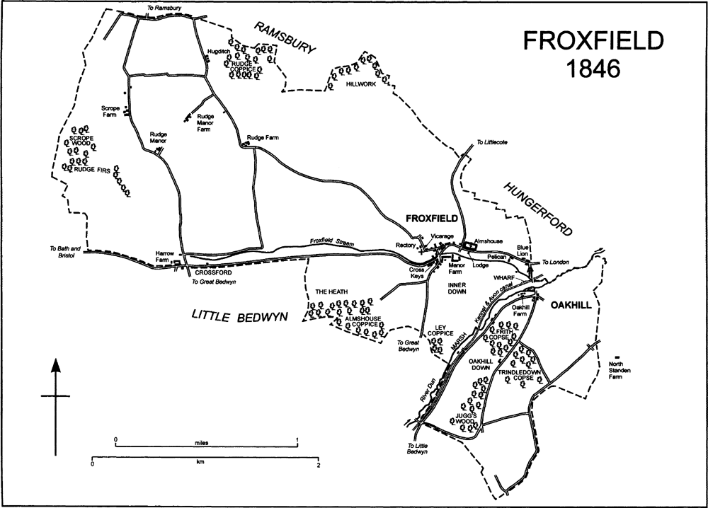
FROXFIELD 1846
Chalk outcrops over the whole parish, in which there are many ridges and dry valleys. The highest land, at 180 m., is in the north-west corner; there and on land at 145 m. south-west of Froxfield village clay-with-flints overlies the chalk. The Dun crosses the parish in the southeast and leaves it at 105 m. A stream now rising in the south-west corner is sometimes called the Froxfield stream; it flows west-east across the parish and into the Dun at the boundary. The Froxfield stream has deposited gravel, the Dun alluvium. (fn. 13) Froxfield, Oakhill, and Rudge each had open fields, downland pasture used in common, meadows on the gravel or alluvium, and woodland. (fn. 14) It is likely that much woodland on the clay-with-flints in the north-west corner was cleared between the Middle Ages and the 18th century. (fn. 15) In the extreme north the highest land is also flat and was part of Ramsbury airfield from 1942 to 1955. (fn. 16)
The population of the parish was 492 in 1801 and at a peak of 625 in 1841, when 423 people lived at Froxfield, 131 at Oakhill, and 71 at Rudge. At Froxfield 85 of the 423 lived in the almshouse. The population was in decline from 1841 to 1921, when it was 285. It was 307 in 1931, between 266 and 293 in the period 1951- 81, and, new housing having been built in the 1980s, 356 in 1991. (fn. 17)
The Roman road from London to Bath may have crossed the high ground in the north-west corner of the parish, but no trace of it survives. (fn. 18) The later road from London to Bath and Bristol probably crossed the parish in the 13th century in the valley cut by the Froxfield stream, (fn. 19) and it was on its present course through Froxfield village in 1675. (fn. 20) It was turnpiked through Froxfield in 1726, disturnpiked in 1871. (fn. 21) In the west part of the parish it was crossed by a north-south road leading from Ramsbury towards Great Bedwyn, of no more than local importance in 1773 (fn. 22) and between Ramsbury and Rudge no more than a footpath in the 19th and 20th centuries. (fn. 23) The crossroads, near where the Ramsbury road also crossed the Froxfield stream, had been given the name Crossford by 1773. The roads linking Froxfield village to Ramsbury and Great Bedwyn in 1995 were on the courses they followed in 1773, as were several roads at Oakhill. (fn. 24)
Beside and crossing the Dun the Kennet & Avon canal was opened through Froxfield parish in 1799 and completely in 1810. It had a wharf and three locks in the parish. (fn. 25) Through Froxfield the canal was restored in the mid 1970s. (fn. 26)
The Berks. & Hants Railway, opened from Reading to Hungerford in 1847, was extended across Froxfield parish along the north-west side of the canal in 1862. The line led to Devizes, from 1900 to Westbury, and from 1906 to Exeter. It had a station at Great Bedwyn. (fn. 27)
There were three bowl barrows in the southwest corner of the parish, possibly the ancient monuments referred to in the early recital of what was apparently Chisbury's boundary. (fn. 28) A Roman villa which stood on or near the Roman road from London to Bath was discovered in 1725; it had a tessellated pavement on which a human figure was depicted, and a bronze bowl made c. 150 A.D. and a stone statuette of Atys were found at the site. (fn. 29) It has been supposed that a cross erected at a site of pagan worship gave a name to Crossford. (fn. 30)
In the 12th and early 13th century the whole parish apparently lay in Savernake forest. From 1228 to 1330 the forest included only the part of the parish south of the London road, and from 1330 none of it. (fn. 31)
Froxfield.
An estate called Froxfield was mentioned 801 × 805. (fn. 32) The village stands on gravel on both sides of the London road, which runs east-west. In 1773 and possibly in 1675 the road made two sharp bends in the village, and a bridge carried a short north-south section over the Froxfield stream. A road from Rudge joined the main road at the bend north of the stream, and a road to Great Bedwyn left it at the bend south of the stream. (fn. 33) About 1791 a short new north-east and south-west section of the main road was made to cut the north corner, and the bridge over the stream was lengthened; when buildings on the south side of the old east-west section north of the stream were removed (fn. 34) the triangle thus created became a village green.
In the 12th century the church was standing (fn. 35) beside the Rudge road at what was presumably then, and was in 1995, the west end of the village, and a house north of the church almost certainly stands on the site of the rector's house. It is likely that the road passed between the church and the house and that the course north and east of the house's garden which it followed in 1773 and 1995 was a diversion. The house, which belonged to the owners of the Rectory estate until 1909, (fn. 36) incorporates a 17th-century east-west range; to the west a truncated and timber-framed building, standing detached in 1995, is aligned with that range and may have been part of the house in the 17th century. In the later 17th century a tall brick cross wing was built to the north at the east end, and in the later 20th century the house was restored and architectural features of various periods were introduced. The vicarage house stood beside the Rudge road immediately east of the church and was replaced by a new vicarage house further north beside the new course of the road. (fn. 37) The demesne farmstead of Froxfield manor, including a farmhouse, stood east of the southern bend of the London road. (fn. 38) A new farmhouse in the west angle of the main road and a minor road to Littlecote in Ramsbury was built in 1849. (fn. 39) The village was extended south-westwards along the Great Bedwyn road apparently in the 17th century. It was extended eastwards in the 1670s, when the almshouse was built, and further east in the 18th century and the 20th. (fn. 40) Most of the village was designated a conservation area in 1993. (fn. 41)
Froxfield apparently prospered because of its position on the main road and from 1799 on the Kennet & Avon canal; railway transport may have undermined that prosperity and have partly caused the decline in the village's population from 1841. (fn. 42) In 1686 there was probably an inn in the village (fn. 43) and in the 18th century there were three. The Cross Keys, on the south side of the main road at its southern bend, may have been the oldest, and the brewhouse behind it gave the name Brewhouse Hill to the Great Bedwyn road. (fn. 44) The inn was repaired in 1758 (fn. 45) and closed c. 1866. (fn. 46) The Blue Lion, on the north side of the main road at the eastern parish boundary, was said in 1718 to have been newly built. (fn. 47) In 1835 it was burned down, (fn. 48) by 1837 had been rebuilt, and c. 1862 was closed. (fn. 49) Architectural evidence suggests that the Pelican, east of the village on the south side of the main road, was newly built when first mentioned in the 1750s. (fn. 50) The Pelican remained an inn in 1995.
The copyhold farmsteads of Froxfield manor apparently stood beside the main road north of the bridge, now the north and west sides of the green. (fn. 51) On the north side of the green in 1995 stood a small farmhouse, apparently of 17thcentury origin, with extensive mainly 20th-century farm buildings around it; also on the north side of the green part of what in 1846 was a house and malthouse (fn. 52) survived as three cottages; at the north-west corner of the green stood another small house of apparently 17th-century origin. Other buildings on the north side of the green in 1995 included a timber-framed and thatched cottage probably of the 17th century, a range of four cottages built in 1871, (fn. 53) and six small later 20th-century houses built on the site of the other part of the house and malthouse. (fn. 54) The site of a small farmstead on the west side of the green was used for a village hall built in 1949. (fn. 55)
South of the Froxfield stream cottages were built on the waste beside the Great Bedwyn road. Three, timber-framed, thatched, and apparently 17th-century, were standing in 1995, as were an early 19th-century house, an early 20thcentury nonconformist chapel, (fn. 56) and four 20th-century houses and bungalows. On the verge of the main road west of its southern bend a timber-framed and thatched cottage was built on the south side in the 17th century, a range of three cottages on the north side in the 18th or early 19th, and a range of six cottages on the south side in 1843. (fn. 57) Further west a commercial garage and a large house were built in the 1920s or 1930s. (fn. 58)
East of the village in the earlier 19th century a group of some five cottages stood on the waste beside the parish boundary and the lane to Oakhill: (fn. 59) all were demolished, most presumably when in 1862 the railway was built (fn. 60) and the lane diverted. When the Blue Lion was closed it and its outbuildings were converted to seven cottages; (fn. 61) all were demolished when the main road was improved in 1968-9. (fn. 62) On the north side of the road, between the almshouse and those cottages, four council houses were built in 1927, (fn. 63) a police house c. 1938, (fn. 64) and eight council houses in 1959-60. (fn. 65) In the lane to Littlecote and near the almshouse a pair of estate cottages was built c. 1960, (fn. 66) and in 1986 a home for the elderly with 38 rooms for residents was built. (fn. 67)
In the mid 20th century new farm buildings were erected east of those of the demesne farmstead in the south-east part of the village. All the old buildings except a weatherboarded barn were demolished, and in 1979 an estate of 15 houses was built on their site. (fn. 68)
Oakhill.
In the 13th and 16th centuries Oakhill was possibly a village of a few small farmsteads and a water mill. (fn. 69) In 1612, 1773, and 1995 it consisted of a farmstead and cottages beside a lane to Little Bedwyn, and to the east cottages at the crossing of that and another lane. (fn. 70) A mill stood at the farmstead until the late 18th century or earlier 19th. (fn. 71) Oakhill Farm, of brick with a mansarded roof and a 19th-century extension, is apparently the house built at the farmstead c. 1750. (fn. 72) In 1910 c. 12 cottages stood at Oakhill. (fn. 73) Two pairs in the lane, early 19th-century and of red brick, were standing in 1995, as were, at the crossroads, two timberframed and thatched 17th-century cottages, an early 19th-century cottage, and a pair of later 20th-century houses.
Rudge.
In the Middle Ages the farmsteads from which most of Rudge's open-field land was worked presumably stood, by analogy with Chisbury, on high ground north of the London road. (fn. 74) The farmsteads probably lay scattered in the 17th century, as they did in 1773, when there were five. (fn. 75) The northernmost, Hugditch, may have been a settlement site in the mid 13th century; (fn. 76) a thatched and timber-framed 17thcentury house stood there in 1995. At Rudge Farm the farmhouse was replaced c. 1810 by a double-pile house, with a principal front of brick and other fronts of banded brick and flint, standing in 1995. At Rudge Manor Farm a timber-framed house of the 17th century, thatched and encased in brick, and an 18th-century cart shed were standing in 1995 among extensive farm buildings mainly of the 20th century. Rudge Manor, part of a farmstead south-west of Rudge Manor Farm, (fn. 77) was demolished in the mid 20th century; a cottage of c. 1870 and a pair of cottages of c. 1950 were standing at the site in 1995. Nearly all the buildings of Scrope Farm had been demolished by the early 1970s, when the farmhouse was largely rebuilt and a house was built in its grounds. (fn. 78)
Other settlement.
In the 13th century a settlement called Teteridge was said to stand in Froxfield parish and to have land beside the London road. (fn. 79) By analogy with Henset, a lost settlement in Little Bedwyn with which it was linked tenurially, (fn. 80) and with Puthall in Little Bedwyn, it may have stood north of the London road near the west boundary of the parish. (fn. 81) It was apparently deserted and there is no direct evidence of its site.
At Crossford a house open as the Harrow inn in 1812 was built in Little Bedwyn parish on the south side of the London road c. 1800. Its outbuildings stood on the north side of the road in Froxfield parish and from 1841 or earlier were used as farm buildings; (fn. 82) they were added to in the 19th century and the 20th. Nearby a pair of cottages standing in 1846 (fn. 83) was replaced by a pair built in 1956. (fn. 84) East of Harrow Farm a turnpike cottage was standing in 1846 (fn. 85) and was demolished in the later 19th century. (fn. 86)
Darrell's Farm, astride the parish boundary and incorporating buildings erected on Ramsbury airfield, (fn. 87) and two pairs of cottages nearby in Froxfield parish were all built in the mid 20th century.
MANORS AND OTHER ESTATES.
Between 801 and 805 Byrhtelm gave Froxfield to Ealhmund, bishop of Winchester, and his see in an exchange. (fn. 88) there is no evidence that Froxfield belonged to the see late, and who held it between the 9th century and the 13th is obscure. The Froxfield which Aelfheah, ealdorman of Hampshire, devised to his nephew Aelfwine c. 970 was probably that in Hampshire. (fn. 89)
The overlordship of Froxfield manor was held as ½ knight's fee in 1242-3 by Baldwin de Reviers, earl of Devon and lord of the Isle of Wight (d. 1245), presumably passed to his son Baldwin, earl of Devon (d. 1262), and was held in 1275 by that Baldwin's heir, his sister Isabel de Forz, countess of Aumale and of Devon. In 1242-3 the manor was held of Baldwin by Walter Marshal, earl of Pembroke (d. 1245), and of Walter by Matthew de Columbers (d. c. 1272-3), the lord of Chisbury manor, whose heir was his brother Michael; in 1275 it was held of Isabel by Walter's heirs and of them by another Matthew de Columbers. (fn. 90) There is no evidence that Isabel's or Walter's successors later had an interest in Froxfield manor, the overlordship of which afterwards descended with Chisbury manor in the Cobham family. It has not been traced after 1389, the year in which John Cobham, Lord Cobham (d. 1408), was overlord. (fn. 91)
Richard de Columbers may have held Froxfield manor in 1212; (fn. 92) John de Columbers held it in demesne in 1242-3 (fn. 93) and granted part of it to his son Nicholas in 1255; (fn. 94) William de Columbers held it in 1275. (fn. 95) In 1295 William's relict Joan, the wife of John de Popham, held the manor for life; her and William's daughter and heir Joan (d. s.p.), the relict of Richard de Popham, then conveyed the reversion to Michael of Droxford. (fn. 96) The manor passed to John Droxford (d. 1329), bishop of Bath and Wells from 1309, to whom in 1303 free warren in his demesne at Froxfield was granted. (fn. 97) John's heir was his brother Michael (d. by 1330), who had entered on the manor by 1328, and Michael's heir was his son John (d. 1341). Michael's title to the manor was challenged in 1328 by his brother-in-law Philip Croke, the nephew of the elder Joan de Columbers, and by Sir William Avenel, the husband of that Joan's niece Joan Croke, and Sir William entered on the manor by force. In 1330 Philip challenged the younger John Droxford's title but in 1332 confirmed it. The manor descended to that John's son Thomas. In 1341, however, Thomas's title was successfully challenged by Joan Croke, then the wife of William le Moyne, (fn. 98) and in 1344 the Moynes conveyed the manor, for a rent of 25 marks a year for their life, to Joan's son William Avenel. (fn. 99)
In 1377 Froxfield manor was conveyed between men who were probably trustees, (fn. 100) and in an exchange licensed in 1390 (fn. 101) it was given by Sir William Sturmy to Easton priory. (fn. 102) The manor belonged to the priory until the Dissolution. (fn. 103) In 1536 it was granted to Sturmy's descendant Sir Edward Seymour, Viscount Beauchamp (fn. 104) (cr. earl of Hertford 1537, duke of Somerset 1547), on whose execution and attainder in 1552 (fn. 105) it passed by Act to his son Sir Edward (fn. 106) (a minor until 1558, cr. earl of Hertford 1559, d. 1621). (fn. 107) From 1553 to 1675 it descended with Tottenham Lodge in Great Bedwyn successively to William, duke of Somerset (d. 1660), William, duke of Somerset (d. 1671), and John, duke of Somerset (d. 1675), (fn. 108) and it passed like Pewsey manor to Sarah, duchess of Somerset (d. 1692). (fn. 109) By her will Sarah gave Froxfield manor and its profits from her death to Froxfield almshouse, which was founded under her will and opened c. 1694. (fn. 110)
In 1920 Froxfield almshouse sold Manor farm, c. 618 a., (fn. 111) and in 1921-2 sold most of its other property in Froxfield. (fn. 112) The farm was bought by G. L. Bevan, (fn. 113) the tenant of Littlecote House in Ramsbury, (fn. 114) who sold it in 1922 to Sir Ernest Wills, Bt. (d. 1958), his successor as tenant and from 1929 the owner of the Littlecote estate. (fn. 115) Shortly after Sir Ernest's death the farm was sold to N. E. James and D. G. W. James, brothers who in 1965 sold c. 365 a. of it, that part north of the London road, to Sir Ernest's grandson (David) Seton Wills (Bt. from 1983), the owner of the Littlecote estate from that year. Sir Seton owned that land as part of the estate (from c. 1985 called the Eastridge estate) in 1995. The Jameses sold the rest of Manor farm, c. 255 a., to William Rootes, Lord Rootes, in 1965, since when that land has been part of the manor of North Standen and Oakhill. (fn. 116)
In 1242-3 OAKHILL was held of Matthew de Columbers and his overlords as Froxfield manor was, (fn. 117) and in 1248 and 1257 was held of William de St. Martin. (fn. 118) From the 13th century or earlier it was part of the manor of North Standen and Oakhill, North Standen later being in Hungerford parish. (fn. 119) Hugh de St. Martin probably held the composite manor in 1234, (fn. 120) and, if he was also Hugh of Standen, held both elements of it in demesne in 1242-3. Oakhill was then assessed at ½ knight's fee. (fn. 121) Hugh de St. Martin was succeeded c. 1247 by his son Peter, (fn. 122) who in 1248 granted the whole manor to Patrick de Chaworth, the overlord of the Standen part, and his heirs, either for 15 years with reversion to Peter or his heirs if by then Peter had issue by his wife Margery, or in perpetuity. (fn. 123) The inheritance passed to Patrick, who c. 1258 died holding the manor subject to the dower of Hugh's relict Joan and Peter's relict Margery (fn. 124) (fl. 1283). (fn. 125) Patrick's relict Hawise of London held the manor until her death c. 1274, when it passed to her son Sir Pain de Chaworth (fn. 126) (d. c. 1279). Sir Pain's heir was his brother Patrick (fn. 127) (d. c. 1283), whose relict Isabel (d. c. 1306), by 1286 the wife of Hugh le Despenser, Lord le Despenser, held it in dower. (fn. 128) About 1306 the manor passed to Patrick's daughter Maud (d. c. 1322), the wife of Henry of Lancaster (earl of Leicester from 1324, earl of Lancaster from 1326, d. 1345). It descended like Berwick St. James manor to Maud's son Henry, earl of Lancaster (cr. duke of Lancaster 1351), on whose death in 1361 it was assigned to his daughter Maud, the wife of William, duke of Bavaria. On the younger Maud's death in 1362 the manor passed to her sister Blanche, the wife of John of Gaunt, earl of Lancaster (cr. duke of Lancaster 1362, d. 1399), and as part of the duchy of Lancaster it was annexed to the Crown in 1399 at the accession of John's son as Henry IV. (fn. 129)
The manor of North Standen and Oakhill was granted in 1548 to Edward, duke of Somerset, (fn. 130) on whose attainder in 1552 the grant was annulled. (fn. 131) The Crown kept the manor until 1608, when it granted it to Sir Edward Phelips (d. 1614), John Seward, and Phelips's heirs. (fn. 132) By 1609 the manor had possibly been acquired by Edmund Hungerford, (fn. 133) who in 1656 sold it to Alexander Popham. (fn. 134) From 1656 to 1962 it was part of the Littlecote estate: it descended with Littlecote House, Chilton Foliat manor, and Rudge farm in the Popham, Leyborne-Popham, and Wills families. (fn. 135) In 1962 G. S. Wills sold it to William Rootes (from 1964 Lord Rootes, d. 1992), who in 1965 added part of Manor farm, Froxfield, to it. In 1992 the whole estate was bought by Mr. Philip Magor, the owner in 1995. (fn. 136)
Land at Rudge descended in the Chamberlain family in the 13th and 14th centuries. About 1268 Geoffrey Chamberlain successfully defended his and William Chamberlain's right to an estate there against William le Deepgate and Thomas le Savage. (fn. 137) The estate may have been held by (presumably the same) William Chamberlain (d. c. 1283), who was succeeded by his son William. (fn. 138) In 1318 it was held by John Chamberlain, the son of (presumably the younger) William, (fn. 139) and before 1330 passed to John's brother William. In 1341 William's title was in doubt, (fn. 140) in 1348 apparently secure. (fn. 141) William Chamberlain (fl. 1376), that William's son and heir, in 1369 conveyed part of the estate to his brother Robert. (fn. 142) The whole was probably what was later called RUDGE farm. It was evidently acquired by a lord of Littlecote manor, possibly in the earlier 15th century by Thomas Calstone, whose right to an estate at Rudge was disputed by William Chamberlain and his wife Christine between 1408 and 1423. Jane Darell, relict of Sir George Darell (d. 1474), held land at Rudge in 1482. (fn. 143) Littlecote manor passed from Sir George to his son Sir Edward, who at his death in 1530 held what became Rudge farm. (fn. 144) The farm, 239 a. in 1831, (fn. 145) descended with the manor and Littlecote House, later also with Chilton Foliat manor and North Standen and Oakhill manor, in the Darell, Popham, Leyborne-Popham, and Wills families. (fn. 146) In 1976 Sir Seton Wills sold part of Rudge farm to G. W. Wilson, and in 1995 he owned 130 a. at Rudge as part of the Eastridge (formerly Littlecote) estate. (fn. 147)
Other land at Rudge was part of Chisbury manor. (fn. 148) In 1573 John Cook, the lord of the manor, sold an estate at Rudge later assessed at 3 yardlands to William George. (fn. 149) The estate apparently became the main part of RUDGE MANOR farm. In 1586 William George conveyed it to his brother John (d. 1611), from whom it passed in the direct line to John (fn. 150) (d. 1651) and Richard (fn. 151) (fl. 1696). (fn. 152) Richard George, presumably another, held the estate c. 1730, (fn. 153) and a Mrs. George held it in 1748. (fn. 154) By 1780 it had apparently been acquired by the Revd. John Gilmore (d. 1820): Gilmore owned Rudge Manor farm, which included two farmsteads and 225 a. (fn. 155) The farm passed to J. P. Gilmore, who sold it to Francis Leyborne-Popham in 1854. (fn. 156) It remained part of the Littlecote estate until 1976, when Sir Seton Wills sold it with other land at Rudge, a total of 479 a., to G. W. Wilson (d. 1984). In 1995 Wilson's son Mr. R. W. Wilson owned c. 550 a. at Rudge. (fn. 157)
In 1577 John Cook sold land at Rudge, later assessed at 2 yardlands and the main part of SCROPE farm, to John Organ alias Taylor. (fn. 158) It passed to Thomas Knapp, whose father Thomas bought other land in Rudge from Edward, earl of Hertford, the lord of Chisbury manor, in 1616. Before 1640 the younger Thomas sold an estate probably including his father's land to Sir Francis Seymour (cr. Baron Seymour 1641, d. 1664). (fn. 159) The estate apparently descended to Seymour's son Charles, Lord Seymour (d. 1665), and to Charles's daughter Frances, whose husband Sir George Hungerford held it in 1678. (fn. 160) By 1682 it had been acquired, presumably by purchase, by Sir James Long, Bt. (d. 1692), who bought land elsewhere from Sir George, (fn. 161) and it apparently passed like Draycot Cerne manor in turn to Sir James's grandsons Sir Robert Long, Bt. (d. 1692), Sir Giles Long, Bt. (d. 1697), and Sir James Long, Bt. (d. 1729). (fn. 162) Sir James devised the estate to his wife Henrietta (d. 1765), who devised it to their grandson Charles Long (d. 1783). It was held by Charles's relict Hannah, the wife of James Dawkins, and passed to his daughter Emma, the wife of William Scrope. (fn. 163) In the early 19th century Scrope farm was of c. 300 a. (fn. 164) In 1818 the Scropes sold 100 a., the south part of it, to Charles Brudenell-Bruce, earl of Ailesbury, (fn. 165) who added it to his other land at Rudge. (fn. 166) Also in 1818 the Scropes sold 203 a. to Francis Leyborne-Popham, (fn. 167) from 1843 the owner of the Littlecote estate, (fn. 168) with which that land passed. In 1949 c. 90 a. of the 203 a. was part of 111 a. in the north-west corner of the parish bought by the Crown to enlarge Ramsbury airfield. In 1954 the Crown sold c. 80 a. to G. W. Wilson, (fn. 169) who bought the rest of the 203 a. from Sir Seton Wills in 1976. (fn. 170)
Land at Rudge, later part of HARROW farm, remained part of Chisbury manor and from 1602 descended with Tottenham Lodge and Tottenham House in the Seymour, Bruce, Brudenell, and Brudenell-Bruce families. (fn. 171) Other land, including 100 a. of Scrope farm in 1818, was added to Harrow farm, (fn. 172) which in 1846 included 159 a. in Rudge and c. 67 a. in Chisbury. (fn. 173) In 1950 the farm was sold by George Brudenell-Bruce, marquess of Ailesbury, to the Crown, the owner in 1995. (fn. 174)
In 1119 the king gave TETERIDGE with Henset in Little Bedwyn to St. Maurice's cathedral, Angers (Maine et Loire). With Henset it belonged to William May and Thomas de Landon c. 1211, (fn. 175) was acquired by Peter des Roches, bishop of Winchester (d. 1238), as an endowment of Netley abbey (Hants), which was founded in 1239, and was given by the abbey to the king in an exchange in 1241. (fn. 176) It may have descended with Henset and, as Henset did, apparently belonged to the owner of Knowle farm in Little Bedwyn from the 15th century. From 1602 Knowle farm and Chisbury manor descended together, (fn. 177) and the land of Teteridge presumably became part of Harrow farm.
Easton priory appropriated Froxfield church between 1396 and 1403, (fn. 178) and held the RECTORY estate until the Dissolution. (fn. 179) The estate, consisting of a house, c. 35 a., pasture rights, and all the tithes from nearly all the parish, (fn. 180) was granted to Sir Edward Seymour, Viscount Beauchamp (later duke of Somerset), in 1536. (fn. 181) In 1547 Seymour gave it back to the king in an exchange and the king granted it to St. George's chapel, Windsor. (fn. 182) Except between 1643 and the Restoration (fn. 183) the chapel kept it until it passed to the Ecclesiastical Commissioners in 1867: (fn. 184) in 1651 the land was sold to Simon Cripps, (fn. 185) and in 1654 the tithes were granted to the almshouses of Windsor castle. (fn. 186) The tithes were valued at £742 in 1845 and commuted in 1846. Of the land, 51 a. after parliamentary inclosure, (fn. 187) 2 a. was annexed to Froxfield vicarage in 1910. (fn. 188) In 1909 a house and 49 a. were bought by Wiltshire county council, (fn. 189) which sold the house in 1910 (fn. 190) and the remaining land, 48 a., in 1961. (fn. 191)
ECONOMIC HISTORY.
Froxfield.
In the 16th century and probably throughout the Middle Ages there were two open fields at Froxfield. About 1536 East field was accounted c. 185 a., West field c. 175 a. (fn. 192) Both were apparently north of the London road. South of the road lay downland, woodland, and, beside the Dun, marsh. There was meadow land west of the village beside the Froxfield stream, other marsh east of the village. (fn. 193) The demesne of Froxfield manor then had 114 a. in the open fields, the copyholds 184 a., the Rectory estate c. 25 a., and a freehold, later assessed at 2 yardlands, (fn. 194) perhaps c. 40 a. There were seven copyholds, the largest of which had 36 a. in the fields, the smallest 13 a.: none had much meadow land or inclosed pasture. The downland south of the road was divided between demesne land, called the Heath and the Inner down, and a down on which in winter the copyholders and the owner of the Rectory estate could keep 500 sheep in common. The freeholder's sheep presumably pastured with the common flock, and on the open fields in summer the tenant of the demesne could keep 300 sheep with it. On the open fields and common downland and on the marsh, most of which was beside the Dun, the copyholders and the owner of the Rectory estate could keep 63 cattle or horses; the tenant of the demesne could keep such beasts on the open fields in summer, and on the Inner down and in Long mead after haymaking 6 beasts kept on the Rectory estate could be fed with his. Besides the open-field arable and the downland the demesne, 319 a., had 9 a. of meadow (including Long mead, 7 a.), 16 a. of several arable, Marsh close comprising 5 a. east of the village, and a several pasture called Hillwork comprising 60 a. north of the open fields. (fn. 195) Later the copyholders were said to feed cattle and horses on the Heath in winter. (fn. 196) Among the copyholders' obligations c. 1536 was work on the demesne for 37 days a year.
In the early 17th century the demesne was apparently divided into two farms, (fn. 197) on one of which c. 1654 the tenant kept only c. 160 sheep in winter, fewer in summer. (fn. 198) By 1683 the demesne may again have been a single farm, and the number of copyholds had evidently been reduced from seven to six. (fn. 199) The downland south of the London road, the marsh beside the Dun, and the marsh east of the village had been inclosed by 1779. (fn. 200) The marsh beside the Dun, c. 24 a., was apparently allotted to the freeholder, who also owned the land of Oakhill, and was added to Oakhill farm; part of it was converted to water meadow. (fn. 201) The Heath, 56 a., and the Inner down, 44 a., parts of the demesne farm, were converted to arable. (fn. 202) Part of the copyholders' down was planted with trees and the rest possibly ploughed; to replace the right to feed 100 sheep and 6 beasts there, and the feeding right on the Inner down, 9 a. was allotted to the owner of the Rectory estate. (fn. 203) About 1785 the demesne, Manor farm, measured 347 a., including 299 a. of arable and 19 a. of water meadows; sainfoin was grown on 30 a. of the Inner down. The six copyholds, totalling 260 a. c. 1785, were brought in hand between 1796 and 1837. (fn. 204)
East and West fields, 441 a., were inclosed under an Act of 1818. The allotments may have been entered on by 1819 although the formal award was not made until 1823. (fn. 205) By allotment and exchange the freeholder, who also owned Littlecote manor and Rudge farm, acquired 112 a. in the north, including Hillwork; afterwards all that land lay in farms based in Rudge or Ramsbury. (fn. 206) Also by allotment and exchange the land of the Rectory estate, 51 a., was concentrated north-west of the church. (fn. 207) About 1846 only two farms were based at Froxfield: Manor farm was of 472 a., including a farmstead in the south-east part of the village, 428 a. of arable, and 10 a. of water meadow, and the other farm was of 215 a. including 177 a. of arable. (fn. 208) A new farmhouse away from the farmstead was built for Manor farm in 1849. (fn. 209) The two farms had been merged by 1901, (fn. 210) and in 1910, when the farmyard was improved and extended, Manor farm measured 662 a. (fn. 211)
From 1909 what had been the land of the Rectory estate became a small dairy farm: as Green farm, c. 70 a., it remained such in 1995. (fn. 212) Manor farm measured 618 a., including 542 a. of arable, in 1919; (fn. 213) it remained predominantly arable, although there were poultry houses and a small herd of cows on it in 1965. (fn. 214) From 1965 its land north of the London road, c. 365 a., was in hand as part of the Littlecote (later Eastridge) estate, and in 1995 it was devoted to arable farming. Its land south of the road was also mainly arable in 1995. (fn. 215)
About 1536 Froxfield had two main areas of woodland, Ley coppice and West wood, probably each of 15-20 a. (fn. 216) Almshouse coppice, 38 a. south-west of the village, had been planted by 1612. (fn. 217) In 1758 Ley coppice, south of the village, measured 27 a. and there was another coppice of 4 a.; (fn. 218) 8 a. along the parish boundary around the north part of Hillwork had been planted as part of Lawn coppice, part of the woodland of Littlecote House, by 1823. (fn. 219) In 1820 the lord of Froxfield manor granted a licence to grub up Ley coppice: 13 a. had been cleared of trees evidently by 1821, but the last 2 a. was not cleared until c. 1857. (fn. 220) North of the village six long and narrow coverts were planted between 1899 and 1922. (fn. 221) They, Almshouse coppice, the part of Lawn coppice, and a coppice of c. 8 a. planted near the village in the later 20th century, (fn. 222) a total of c. 60 a., were standing in 1995.
In the later 18th century and earlier 19th Froxfield was apparently a minor centre for malting and brewing. There was a malthouse and brewery at the Cross Keys run by Thomas Noyes until c. 1771 and afterwards by his brother William, who by c. 1785 had expanded the business (fn. 223) and in 1793 sold it to William Newbury. (fn. 224) A new brewhouse fronting Brewhouse Hill was built in 1843. (fn. 225) Brown & Hillary were brewers and maltsters at Froxfield in 1830, (fn. 226) there were two maltsters in 1841, (fn. 227) and a malthouse was standing on the north side of the Green in 1846. (fn. 228)
Froxfield wharf on the Kennet & Avon canal was presumably used by local carriers in the 19th century, (fn. 229) but a shed standing in 1846 and 1878 (fn. 230) is the only building known to have been erected there.
Oakhill.
The open fields and common pastures of Oakhill were part of North Standen and Oakhill manor from the 13th century, and presumably included both demesne and customary land. In 1257 the demesne of the composite manor included 225 a. of arable, 9 a. of meadow, a several pasture called Oakhill sufficient for 16 oxen, a marsh sufficient for 4 beasts, and pasture for 200 sheep; the eight customary holdings were small, including only 68 a. of arable, and between them the tenants had to work for 14 days and to plough 2½ a. Oakhill marsh, beside the Dun, was then held by the lord of Froxfield manor. It is likely that the demesne was worked from buildings in North Standen, (fn. 231) as it was later, and that some of the customary holdings were based at Oakhill. (fn. 232) In 1283 the demesne was roughly the size it was in 1257 but there were said to be 13 customary tenants each holding 1 yardland; the tenants' services included carrying writs. (fn. 233)
In 1552 the demesne arable of the manor was several, and most of it was almost certainly in the North Standen part of it. There were four copyholders. Their 3½ yardlands included 120 a. of arable, a 20-a. cow pasture, 7 a. of meadow, and 8 a. of several pasture; most of their land was almost certainly in Oakhill. The manor's 223 a. of common pasture, on which the lessee of the demesne could keep 300 sheep, the copyholders 90, included Oakhill down, 60 a. in the south part of Oakhill. The lessee could keep 30 cattle or horses, the copyholders 9; (fn. 234) in 1564 it was ruled that none might feed on Oakhill down. In 1562 there was apparently an exchange between the lessee of the demesne and the copyholders: the lessee gave up his pasture rights in Oakhill, (fn. 235) and from c. 1605 the demesne was a several farm mainly confined to North Standen. (fn. 236) From 1562 the open arable, marsh, common meadow, and common downland of Oakhill was apparently used mainly by the four copyholders, whose farmsteads may have stood at Oakhill. In 1591 the four could keep 44 cattle and c. 170 sheep, but the number of sheep they could keep was halved in alternate years. A few farms worked from Little Bedwyn parish included 10-20 a. of the open arable. (fn. 237)
The open fields of Oakhill were inclosed under an agreement of 1722, (fn. 238) and in the early 19th century all Oakhill's land lay in severalty and in either Oakhill farm, 210 a. in 1831, or North Standen farm. About 1846 Oakhill farm, 268 a., included 200 a. of arable, 17 a. of water meadow, 10 a. of marsh, and 33 a. of pasture on Oakhill down. North Standen farm then included 62 a. in Oakhill. (fn. 239) For a few years c. 1918 Oakhill farm, still 268 a., was held by A. J. Hosier and his brother Joshua. (fn. 240) It measured 277 a. in 1961, (fn. 241) and in the late 20th century was mainly arable. (fn. 242)
Trindledown copse was mentioned in the 13th century, (fn. 243) Frith copse in 1552, when both were estimated at 10 a. (fn. 244) They measured 15 a. and 13 a. respectively c. 1846, (fn. 245) 16 a. and 15 a. in 1995. Jugg's wood was standing in 1612 (fn. 246) and was so called in 1720. (fn. 247) It measured 16 a. c. 1846, (fn. 248) 18 a. in 1995. In the later 20th century c. 12 a. of woodland was planted beside the eastern parish boundary. (fn. 249) Partridges and pheasants were kept on North Standen and Oakhill manor in the 16th century. (fn. 250)
Watercress beds of c. 1 a. were constructed on the Dun north-east of Oakhill Farm between 1883 and 1899; (fn. 251) they were used by growers with larger beds at Ramsbury (fn. 252) and went out of use in 1968. (fn. 253)
A mill on the demesne of North Standen and Oakhill manor in 1257 (fn. 254) probably stood at Oakhill, where a demesne mill stood, and was to be rebuilt, in 1373. (fn. 255) In 1479-80 the mill stood idle while it was repaired and while the mill stream was scoured and two new stones were brought from St. Briavels castle (Glos.). (fn. 256) By 1528, when the lessee of the demesne of the manor agreed to build a new mill, it had apparently been demolished. The agreement was not kept, (fn. 257) but c. 1605 a new mill, with a new weir, two new hatches, a new channel, and a new pond, was built on the Dun on the site of the old. It was alleged that the new mill lessened the flow of water and trade to mills at Hungerford. (fn. 258) It was in use in 1758 (fn. 259) and standing in 1793. (fn. 260) Water from the Dun was used to supply the Kennet & Avon canal, (fn. 261) and the mill had been demolished by 1846. (fn. 262)
Rudge.
Meadow land of Rudge lay beside the Froxfield stream, three open fields lay immediately north of the meadow land, and woodland and common pasture lay on higher ground further north. (fn. 263) There was possibly 250-350 a. of arable, (fn. 264) of which about a quarter was part of farms worked from Chisbury. In the early 18th century the fields were called West, Little, and Fisher. (fn. 265) By the 15th century some of the pasture and woodland had been inclosed and converted to arable, (fn. 266) and much had been inclosed by the mid 17th century. In 1565 a holding included 25 a. in the open fields and 15 a. in closes, and in 1641 a holding included 41 a. in the open fields and c. 50 a. in closes. (fn. 267)
Although in 1665 it was agreed to inclose the open fields and the common pasture called the Heath, (fn. 268) they were apparently not inclosed until between 1719 and 1741. In 1741 what was later Scrope farm included West field, 78 a., and 23 a. of the Heath. That farm, c. 286 a., then had 270 a. of arable in 18 closes; (fn. 269) in 1770 it had 328 a., of which 301 a. was arable. (fn. 270) In 1773 Rudge's five farmsteads were dispersed but not far from its centre. (fn. 271) In 1818 Scrope farm was divided, (fn. 272) and thereafter that part of its land in Rudge's south-west corner, with other land there, was worked as Harrow farm from a farmstead beside the London road; the farmhouse, on the south side of the road and in Little Bedwyn, was formerly the Harrow inn. About 1846 Rudge's land lay in Rudge Manor farm, 221 a., Scrope farm, 212 a., Rudge farm, 245 a., and Harrow farm, 159 a.; the farms included 733 a. of arable. (fn. 273)
There remained four farms in 1910, but Scrope and Rudge Manor, 511 a., were then and later worked together. (fn. 274) Part of Rudge farm was added later, and in 1995 c. 550 a. of Rudge was worked with land in Ramsbury as Rudge Manor farm, an arable and beef farm of 770 a. (fn. 275) Also in 1995 Harrow farm, 322 a. including land in Little Bedwyn, was mainly arable, (fn. 276) and the rest of Rudge farm, c. 130 a., was in hand as part of the Eastridge (formerly Littlecote) estate and was arable. (fn. 277) Buildings in Froxfield parish were among those on the southern edge of Ramsbury airfield which after 1955 were converted for agricultural use and added to. As Darrell's Farm they were used for pig keeping in 1981 and 1995. (fn. 278)
Woodland was part of an estate at Rudge in the 14th century, (fn. 279) and in the 18th century there were small coppices on Scrope farm. (fn. 280) The 54 a. of woodland c. 1846 included Rudge coppice (25 a.) north-east of Rudge Manor Farm, and Scrope wood (11 a.) and Rudge firs (10 a.) south-west. (fn. 281) Those woods were standing in 1995.
A mill owned by the lord of Chisbury manor stood on the Froxfield stream 1 km. west of the church in 1589 and 1612. (fn. 282) It had apparently been demolished by 1694. (fn. 283)
LOCAL GOVERNMENT.
There are records of Froxfield manor court for 1480-4, 1506, 1582-3, 1616-17, 1619, and 1715-1832. The court was held twice a year in the 15th century, once a year in the 16th and possibly the earlier 17th, every few years in the earlier 18th, and again once a year from c. 1750. In all those periods it transacted general manorial business: the death of tenants was reported, surrenders and admittances were witnessed, and matters such as encroachment on the waste, misuse of land worked in common, dilapidation of buildings, and unlicensed tree felling were dealt with. In the period 1480-4 the condition of hedges seems to have been of particular concern. In the 18th century some rules governing husbandry in common and some customs of the manor were repeatedly recorded. (fn. 284)
A view of frankpledge and a manor court were held for North Standen and Oakhill manor in the later 15th century, usually one or two of each a year. They may have transacted little business, and none was held in 1470-1, 1479-80, or 1492- 3. (fn. 285) A view of frankpledge and court baron met twice in the period 1542-5: it punished and bound over the perpetrators of three assaults and ordered the construction of new stocks, but most business, such as the condition of boundaries, hedges, and gates and the use of common pastures, was agrarian. (fn. 286) In the period 1562-72 the court met four times, dealt with copyhold business, and recorded rules governing agriculture on the manor. (fn. 287)
The parish spent £164 on the poor in 1775-6 and an average of £128 in the three years to Easter 1785. The poor rate was high in 1802-3 when £355 was spent and 38 adults and 106 children, about a third of the population of the parish excluding the almshouse, were relieved regularly. (fn. 288) Expenditure had almost doubled by 1812-13, when it was £691 and 143 people were relieved, but was never as high again. It fluctuated between £297 and £561 in the period 1816-34. (fn. 289) The parish joined Hungerford poorlaw union in 1835 (fn. 290) and became part of Kennet district in 1974. (fn. 291)
CHURCH.
Froxfield church was standing in the 12th century. (fn. 292) In the earlier 13th century the rector received all tithes from Chisbury and presumably served the church there. Before 1246 he gave the tithes, and presumably the duty of serving the church, to St. Denis's priory, Southampton. In 1259 the rector claimed that the priory's tenure of Chisbury church was temporary and that it should revert to him, (fn. 293) but the priory kept it. (fn. 294) Froxfield church was appropriated by Easton priory between 1396 and 1403, (fn. 295) and in 1403 a vicar was instituted. (fn. 296) In 1976 the vicarage was added to Whitton benefice. (fn. 297)
The overlord of Froxfield manor, Sir Henry Cobham, presented a rector in 1307 and in 1311. His right to present was challenged unsuccessfully by the lord of the manor, John Droxford, bishop of Bath and Wells, who presented a rival rector in 1311. The advowson descended in the Cobham family with the overlordship and with the lordship of Chisbury manor; for reasons that are obscure the bishop of Salisbury collated in 1348. (fn. 298) Between 1386 and 1390 John Cobham, Lord Cobham, sold the advowson to Sir William Sturmy, who between 1396 and 1398 gave it to Easton priory. (fn. 299) From when the church was appropriated the advowson of the vicarage passed until 1867 with the Rectory estate, the owners of which, Easton priory, Edward, duke of Somerset, and St. George's chapel, Windsor, presented all the vicars except one: in 1454 the bishop collated by lapse. St. George's chapel kept the advowson when the estate passed to the Ecclesiastical Commissioners, (fn. 300) and in 1926 gave it to the Church Patronage society in an exchange. (fn. 301) From 1976 the Church Patronage trust had a seat on the board of patronage for Whitton benefice. (fn. 302)
In 1291 the rectory was worth £8 a year. (fn. 303) The vicarage, valued at £7 16s. 4d., was poor in 1535, (fn. 304) when the vicar's income was derived mainly from a pension of £7 6s. 8d. from the Rectory estate. (fn. 305) In 1625 St. George's chapel augmented the vicarage by £4 a year said to be for serving the cure. (fn. 306) From 1660 the pension was £17 6s. 8d., (fn. 307) and from 1678 or earlier the chapel, and later the Ecclesiastical Commissioners, paid a total of £28 a year from the Rectory estate to the vicar. (fn. 308) The living was augmented in 1738 by £400 of which Queen Anne's Bounty gave half, in 1816 by a parliamentary grant of £1,400 by lot, in 1834 by a rent charge of £20 given by St. George's chapel, and in 1835 by £400 of which parliament gave half. (fn. 309) At £122 the vicar's income was still small c. 1830. (fn. 310) On the expiry of the lease of the great tithes the Ecclesiastical Commissioners augmented it in 1881. (fn. 311) The rector apparently took all tithes from nearly all the parish. (fn. 312) The vicar apparently took none. (fn. 313) The rector almost certainly had a house immediately north of the church (fn. 314) and in 1341 had arable estimated at 40 a. and a several pasture worth 19s. 4d. (fn. 315) The vicar's glebe consisted of no more than the vicarage house. (fn. 316) In 1674 the house was dilapidated and in danger of collapse, (fn. 317) and by 1680 the south part had fallen. The house was demolished in 1734, when a new house, with two rooms on each of two floors, two garrets, and a skilling, was built on higher ground in the north part of its garden. (fn. 318) About 1830 the new house was said to be unfit for residence, (fn. 319) and c. 1846 it was used as a pair of cottages. (fn. 320) A new, much larger, house was built in 1882-3; its west gable wall and the west part of its north wall are those of the house of 1734. (fn. 321) It was sold in 1967. (fn. 322)
John of Ogbourne, an acolyte when instituted as rector in 1311, was permitted to study at an English university for two years from his institution, (fn. 323) and Ellis Nethway, presented in 1394, was permitted to be non-resident and to lease the church for a year. (fn. 324) In 1553 the parishioners reported that the church had no pulpit, (fn. 325) in 1556 that goods belonging to the church were in private hands, (fn. 326) and in 1584 and 1585 that quarterly sermons were not preached. In 1584 the vicar's wife was among several who failed to receive the sacrament at Easter. (fn. 327) From the 17th century to the 20th vicars usually resided. (fn. 328) Geoffrey Godwin was vicar 1628-69. (fn. 329) His successor Thomas Foster composed and entered in the parish register a verse denigrating his parishioners for their ignorance; he rewrote it after a parishioner had blotted it out. (fn. 330) The vicarage house was not fit to be lived in, (fn. 331) Foster lived two miles away, and on Sundays no service was held in the morning and sometimes none before 5 p.m. (fn. 332) Thomas Brown, vicar 1773-88, lived at Stratford Tony, where he was rector. At Froxfield his curate, who also served Little Bedwyn, in 1783 held one service each Sunday, celebrated communion at the great festivals with 6-8 communicants, and lived in the vicarage house. (fn. 333) The vicar 1788-1827 was the mathematician and astronomer Lewis Evans, a contributor to the Philosophical Magazine. He had a private observatory at Woolwich, where he taught from 1799 to 1820, and in 1821 built an observatory incorporating a transit clock at the vicarage house at Froxfield. (fn. 334) He usually employed a curate at Froxfield: one, James Davidson, was in 1799 a proponent of a history of Wiltshire; another, John Gilmore, owned Rudge Manor farm. (fn. 335) In 1812 services were held with the same frequency as in 1783. (fn. 336) Lewis's successor, T. G. P. Atwood, lived in the house on the Rectory estate. In 1863-4 he held two services each Sunday and additional services on Christmas day and Good Friday, celebrated communion seven times, and catechized in the church. The congregation averaged c. 100 in the morning, c. 170 in the evening, and c. 250 on Christmas day and Good Friday; the church was considered too small. (fn. 337) The vicarage was held in plurality with that of Little Bedwyn from 1958 to 1965, and with Chilton Foliat rectory from 1966 to 1975. (fn. 338)
Although the founder of Froxfield almshouse intended that the rector of Huish should be the chaplain of the almshouse, (fn. 339) the minister serving Froxfield church was usually the chaplain, acting either as a curate appointed by the rector of Huish or as an appointee of the trustees of the almshouse. (fn. 340)
The church of ALL SAINTS, so called in 1763, (fn. 341) is built of flint and sarsen rubble with freestone dressings and consists of a chancel with north vestry and organ chamber and a nave with south porch and west bell turret. (fn. 342) The nave, small and with thick walls, is 12th-century; the chancel was rebuilt in the 13th century. In the 14th century new windows were inserted in the north and south walls of the nave, and a new doorway was made in its north wall, and in the 15th century a new west window was inserted. A partly timber porch was apparently built in the 15th century. (fn. 343) At a restoration of 1891-2 to designs by Ewan Christian the porch was rebuilt, the roofs of the chancel and the nave were renewed, and a more elaborate bell turret was erected; the nave was reseated, and a west gallery was removed and its simple south window replaced by one in 15th-century style; the chancel arch was reconstructed, the chancel restored, and the vestry and organ chamber, in transeptal form, built to replace a small vestry north of the chancel. (fn. 344)
Froxfield retained an 11-oz. chalice in 1553 when 2 oz. of plate was taken for the king. In 1995 the parish had a richly ornamented Dutch or German chalice, dated 1619 and formerly gilt, and a paten hallmarked for 1854. (fn. 345)
The church had two bells in 1553. (fn. 346) The two in the church in 1671 were small and defective (fn. 347) and may both have been replaced in 1672. There hung in the church in 1995 a bell cast in 1672 by Henry Knight of Reading and an uninscribed bell possibly of similar date. (fn. 348)
The registers begin in 1561 and are complete, entries to c. 1609 being transcripts. (fn. 349)
NONCONFORMITY.
Those in a small group which failed to receive the sacrament at Easter in 1584 (fn. 350) may have been nonconformists. Froxfield had no nonconformist in 1676 and 1783. (fn. 351) Independents certified a meeting house at Froxfield in 1813, certified another in 1844, (fn. 352) and had a place of worship there in 1882. (fn. 353) In 1834 Wesleyan Methodists certified two houses for worship at Froxfield and in 1836 a house at Rudge. (fn. 354) A few Wesleyans who met in a cottage were said to be the only dissenters in the parish in 1864. (fn. 355) A small red-brick chapel for Primitive Methodists was built in Brewhouse Hill in 1909 (fn. 356) and closed c. 1962. (fn. 357)
EDUCATION.
In 1783 two dame schools were held in the parish, one in the almshouse. (fn. 358) In 1833 there were two day schools at which 13 boys and 22 girls were taught, (fn. 359) and in 1858, when most children went to school at Little Bedwyn, there was a dame school for a few young children. (fn. 360) There was no school in the parish in 1818, when some children went to one at Hungerford, (fn. 361) 1846-7, (fn. 362) and 1864, when the children went to Little Bedwyn. (fn. 363) A school in the parish, probably in Brewhouse Hill, had been opened by 1871, when 22 boys and 31 girls attended it on return day, (fn. 364) but in 1884 there was only an infants' school at Froxfield and children over six went to Little Bedwyn. (fn. 365) A school in Brewhouse Hill was rebuilt in 1885, (fn. 366) had an average attendance of 44 in 1906-7, and was closed in 1907. (fn. 367) A new school, designed by W. B. Medlicott and built near the church, was open from 1910 to 1963. Average attendance was 45 in 1910-11, 34 in 1937-8. (fn. 368)
CHARITIES FOR THE POOR.
Robert Barber (d. by 1609) gave 2s. a year to be paid to the poor of Froxfield while his wife lived, and on her death 40s. or a cow as a stock. In 1611 William Fabian gave £3 as a stock for the poor. Both charities had been lost by 1786. (fn. 369)
Boys of Froxfield were eligible to benefit from the Broad Town charity, an apprenticing charity set up in the 1690s under the will of Sarah, duchess of Somerset. (fn. 370) In the late 20th century, when it was called the Broad Town trust, the charity helped young men entering employment or contributed to their education; in certain circumstances young women could be helped, and young people of Froxfield remained potential beneficiaries. (fn. 371)
Froxfield Almshouse.
Sarah, duchess of Somerset, the wife of George Grimston (d. 1655), from 1661 to 1675 of John, duke of Somerset, and at her death in 1692 of Henry Hare, Lord Coleraine, (fn. 372) by her will directed her executors to found an almshouse at Froxfield and gave a site and money for it to be built and furnished. She prescribed a brick building which would enclose a quadrangle and have 30 houses each with a ground-floor room and a room above it. The occupants were to be 30 widows: half, 10 from Wiltshire, Somerset, or Berkshire and 5 from London or Westminster, were to be of clergymen, and half, 10 from manors (including Froxfield) which she owned and 5 from elsewhere in Wiltshire, Somerset, or Berkshire, were to be of laymen. A chapel was to be built in the court. The widows, who would qualify for residence if their inheritance was worth less than £20 a year, were to be given pensions and a cloth gown each year and the chaplain was either to be paid or to be presented as rector of Huish. In 1682 the duchess settled in trust land including Froxfield manor previously settled on the duke, herself, and the heirs or assigns of the survivor; by her will she gave the advowson of Huish to the trustees and directed them to endow the almshouse with that and the land. The income from the endowment was expected to rise and to become sufficient for the almshouse to be extended. (fn. 373)
Froxfield almshouse was built as the duchess prescribed by her executor Sir William Gregory. It was finished in 1694 or 1695 and widows were installed. The duchess's brotherin-law, Sir Samuel Grimston, Bt., the survivor of the trustees appointed in 1682, refused to convey the duchess's land to her executors, and after Gregory's death in 1696 his executors refused to transfer the income from it to the almshouse: by a decree of 1698 Chancery appointed local landowners as trustees of the almshouse, compelled the transfer of the endowment and its issues to them, and gave orders for the management of the almshouse. (fn. 374) Later questions of management and trusteeship were also referred to Chancery, which in 1729 sanctioned a body of 14 rules governing the duties of the trustees and the steward, the conduct of the widows, the performance of divine service in the chapel, and the locking of the outer door of the almshouse. The trustees nominated one of the widows as a matron to report on the behaviour of the other widows, carry a white wand, and receive £1 a year. Such nominations had ceased by the 1780s. (fn. 375)
As expected, the almshouse's income grew in the 18th century, and in 1772-5 the building was enlarged to accommodate 50 widows. (fn. 376) As prescribed by the duchess, 5 of the additional 20 were to be from London or Westminster, 15 from any part of England except Wiltshire, Somerset, and Berkshire and anywhere more than 150 miles from London: 5 of the 20 were to be the widows of clergymen. (fn. 377) Pensions had increased from £6 in 1716 to £10 10s. in 1771 and, despite the enlargement of the almshouse, continued to increase. By the 1770s money was given instead of gowns. About 1833 each widow received £38 a year; the demand of laymen's widows for places was great and places for clergymen's widows were not easily filled, but the 50 places were occupied by the several categories in the prescribed numbers. The chaplain of the almshouse was then paid £50 a year, and salaries were paid to an apothecary, a receiver, a bailiff, a porter, and a chapel clerk. (fn. 378) From 1838 to 1851 the pensions were £40 a year. (fn. 379)
The almshouse's income declined in the later 19th century and earlier 20th. The pensions were reduced to £36 in 1851 and had fallen to £26 by 1882, from when accommodation was left vacant to avoid reducing them further. (fn. 380) As vacancies increased the occupants were not in the prescribed categories in the correct proportions, and in 1892 the trustees of the charities of St. John's and St. Margaret's parishes, Westminster, complained of under-representation for London and Westminster. After an inquiry by the Charity Commissioners in 1897, when only 16 widows lived in the almshouse, it was agreed that more from those areas should be installed. The inquiry found that the complicated system by which individual trustees in turn presented widows was open to objection. In 1907 there were 16 resident widows of whom 7 were of clergymen: 3 of the 16 were from London or Westminster, 3 from the duchess's manors. (fn. 381)
In the early 1920s the almshouse sold its lands and invested the proceeds. (fn. 382) In 1921-2 the number of resident widows was increased from 13 to 25 and the pensions were doubled to £52; a chaplain, a surgeon, a steward, a porter, and a matron were employed. (fn. 383) Under a Scheme of 1926 new rules were made for managing the almshouse, and the admittance of unmarried daughters of clergymen was permitted; under a Scheme of 1958 a matron, if appointed, was entitled to occupy one of the individual houses and the residents could be charged; and under a Scheme of 1966 any poor woman of 55 or more could be admitted. In the later 20th century the charges, in 1986 £21 a week from each resident, and money given privately, by other charities, and by public bodies, were spent on maintaining and improving the almshouse. (fn. 384) There were 46 individual houses, one of which was reserved for guests, and 4 flats in 1995, when there was no resident matron. Each house then had a room and a kitchen on the ground floor, and a room and a bathroom on the first floor. There was a resident warden. (fn. 385)
As built in 1694 the two-storeyed almshouse (fn. 386) enclosed a square courtyard, in the centre of which stood the chapel. There was a house at each corner, between them there were seven houses on each side, and there was a narrow passage both east of the house at the north-west corner and west of the house at the north-east corner. The London road runs past the south side. Besides the 30 houses for widows, the slightly larger house at the centre of the south side was apparently a lodge, and that at the south-east corner was apparently used by the steward. (fn. 387) A cupola was erected in 1759, (fn. 388) presumably over the lodge. Between 1772 and 1775 the seven houses on the east side were demolished, what were apparently the lodge and the steward's room were converted for use by widows, and to the east 26 new houses and a lodge were built. The almshouse then enclosed a rectangular court: a row of nine houses was attached to the house at the old north-east corner, a narrow passage separated the row from the house at the new north-east corner, seven houses were built between that house and the steward's house at the new south-east corner, and eight houses were built between the steward's house and the new lodge, which linked the old and new parts of the south front. Facing the London road the lodge had a central pediment above an inscribed panel and a doorway with a segmental pediment. A cupola, possibly that of 1759, a weathervane dated 1772, and a clock were put up over the lodge. The grounds of the almshouse were walled. To the south the wall was low and outside it a terrace was made, from 1781 connected to the London road by steps; to the east and north the wall was higher and enclosed gardens. (fn. 389) In 1814, the year in which the new chapel was built, it was proposed that the lodge should be rendered; it was rebuilt in stone to harmonize with the chapel, presumably in that year when work was being done on it, and the inscription was engraved anew. In 1818 the steps were remade with parapet walls and an iron wicket. (fn. 390) On the south side of the almshouse wooden surrounds to the windows were kept in the 17th-century range, stone ones in the 18th-century range, when the fenestration on that side was rearranged in the 19th century. On the south side of the London road and facing the lodge a small red-brick house was built for the porter c. 1833. (fn. 391) It was sold in 1965 and replaced by a warden's bungalow north of the almshouse. (fn. 392)
Although the rector of Huish may nominally have been chaplain, the chapel was usually served by the minister serving Froxfield church. (fn. 393) In 1729 it was ruled that there should be divine service in it every day and, with a sermon, twice on Sundays; the rule was not being observed in 1786, (fn. 394) and in 1907 services were thrice-weekly. (fn. 395) Services were held regularly in 1995. The chapel built between 1692 and 1695, from 1772-5 standing in the west part of the enlarged quadrangle, (fn. 396) was presumably of red brick and apparently in plain Gothic style; (fn. 397) it was demolished in 1813. A new chapel, designed by Thomas Baldwin and paid for by Charles Brudenell-Bruce, earl of Ailesbury, was built in the centre of the quadrangle in 1813-14. (fn. 398) It is of stone in neo-Gothic style and was restored in 1963. (fn. 399) It has a chalice and a paten each hallmarked for 1695. (fn. 400)