A History of the County of Wiltshire: Volume 17, Calne. Originally published by Victoria County History, London, 2002.
This free content was digitised by double rekeying. All rights reserved.
'Berwick Bassett', in A History of the County of Wiltshire: Volume 17, Calne, ed. D A Crowley (London, 2002), British History Online https://www.british-history.ac.uk/vch/wilts/vol17/pp9-17 [accessed 30 April 2025].
'Berwick Bassett', in A History of the County of Wiltshire: Volume 17, Calne. Edited by D A Crowley (London, 2002), British History Online, accessed April 30, 2025, https://www.british-history.ac.uk/vch/wilts/vol17/pp9-17.
"Berwick Bassett". A History of the County of Wiltshire: Volume 17, Calne. Ed. D A Crowley (London, 2002), British History Online. Web. 30 April 2025. https://www.british-history.ac.uk/vch/wilts/vol17/pp9-17.
In this section
BERWICK BASSETT
Berwick Bassett village lies 12 km. SSW. of Swindon. (fn. 1) The long and narrow parish, 563 ha. (1,391 a.), lies east-west and a head stream of the river Kennet flows north-south across the middle of it; with Winterbourne Bassett and Winterbourne Monkton it is one of three similarly-shaped parishes in the upper Kennet valley. Its name suggests that Berwick Bassett originated as a settlement before 1066 (fn. 2) and, not mentioned in Domesday Book, in 1086 it was probably part of the king's estate called Calne. (fn. 3) Berwick Bassett had no church probably until the early 13th century. Before then its inhabitants attended Winterbourne Bassett church and paid tithes to Calne church. Berwick Bassett church was a daughter of Calne's (fn. 4) but the inhabitants had rights to baptism, marriage, and burial at Berwick Bassett by the early 15th century, (fn. 5) and Berwick Bassett was later a civil parish. The suffix Bassett, the surname of lords of the manor in the 13th century, had been added by the earlier 14th century. (fn. 6)
On the east the north-south part of the parish boundary is marked by an ancient road, on the north-west the boundary was marked by another road, (fn. 7) and on the south the western part follows a stream and a ridge west of the stream, but for most of its length the boundary follows no natural or prominent man-made feature. On the north the western part of the boundary with Winterbourne Bassett was described as uncertain c. 1760 and may have been defined anew at an exchange of lands in 1782. (fn. 8) South-east of Berwick Bassett village there is a zig-zag where the boundary with Winterbourne Monkton followed that of furlongs in open-field land; (fn. 9) boundary stones were standing on part of the zig-zag in the 19th century. (fn. 10)
Chalk outcrops over the whole parish; there are deposits of gravel beside the head stream south of the village and of clay-with-flints in the extreme east. (fn. 11) Both east and west of the head stream the land rises to the parish boundary, reaching 271 m. in the east, where the scarp of Hackpen Hill crosses the parish, and 187 m. in the west; in the centre the land is at 160 m. There were open fields in the east and west parts of the parish, downland pastures on Hackpen Hill and in the extreme west, and little woodland. (fn. 12)
Berwick Bassett had 55 poll-tax payers in 1377. The population of the parish was 158 in 1801, 133 in 1811. From 1811 to 1851 it rose, reaching a peak of 203, and in the later 19th century and the 20th it declined, with some fluctuations: it was 134 in 1881, 165 in 1891, 74 in 1911, (fn. 13) and 69 in 1961. From its low point of 40 in 1971 it had risen to 51 by 1991. (fn. 14)
The road along the parish boundary on the east is the ancient Ridge Way. (fn. 15) That along it on the north-west, linking Broad Hinton and Yatesbury, was called Corten Lane in 1728, 1773, and 1820, Whibston Lane c. 1760, and Yatesbury Lane in 1828 and later; it has never been tarmacadamed and was little used in the late 20th century. By the earlier 18th century the head stream of the Kennet had been bridged at Berwick Bassett village and, via the bridge, a north-south road along the east bank of the stream led south from Berwick Bassett to Avebury. A north-south road along the west bank of the stream may earlier have led north from the village to Richardson in Winterbourne Bassett, have linked other villages in the upper Kennet valley, and have been passable by coach; it was not marked on maps of 1728, 1773, or later. Another north-south road crossed Berwick Bassett parish on higher land further east and was linked by the bridge and Franklyn's Lane, so called in 1728, to Berwick Bassett village. (fn. 16) In 1769 Franklyn's Lane, probably then called Butt's Lane, the north part of the higher north-south road, and the road south of the village and on the east bank of the stream were turnpiked as part of a Swindon-Devizes road, which thus had two sharp bends in the parish. Disturnpiked in 1870, (fn. 17) that road remained an important north- south route in 1994. The southern part of the higher road had become a bridleway by 1992. (fn. 18) A road which in the 18th century led west across the parish from Berwick Bassett village was a farm track in 1994, and there were east- west tracks between the higher north-south road and Hackpen Hill in the earlier 18th century (fn. 19) and the late 20th.
Few traces of prehistoric activity have been found in the parish. There are two barrows in its north-east corner, and a palaeolithic axe was found nearby. (fn. 20)
The whole of Berwick Bassett village stands west of the head stream. The farmsteads were built in a loose group, possibly as a planned settlement when the open fields were laid out east and west of them, and were linked by a roughly north-south lane. The northernmost farmstead is that which probably stood on the demesne of Berwick Bassett manor and, between c. 1199 and 1221, the church was built immediately north of it. Near the middle of the village the lane widened and by 1728 had been linked to Franklyn's Lane by the bridge. The wide part of the lane west of the bridge formed a small triangular green on which there was little grass in 1994. East of the stream there was a building north of the bridge in 1728 (fn. 21) and one south of it c. 1760; (fn. 22) both had been demolished by 1839. (fn. 23)
In 1728 there were only four farmsteads in the village; the houses there included two small manor houses, in 1994 called the Old Farmhouse and the Manor, and several small houses or cottages. The Old Farmhouse was the house probably on the demesne of Berwick Bassett manor and stood near the church; the Manor (formerly Manor House) stood south-east of it. Extensive farm buildings near the Old Farmhouse were largely renewed in the 20th century. There was a large farmstead in the middle of the village in the 18th century (fn. 24) and the 20th, when it was called Berwick House Farm. The farmhouse may be of 17th-century origin and was much extended in brick in the 19th century; in 1994 the farm buildings were mainly 20th-century.
The other buildings standing in 1728 were replaced in the 18th, 19th, and 20th centuries, and in that period few buildings were erected on new sites. (fn. 25) In the north part of the village a thatched cottage was built in the 18th century, a school in the mid 19th century, (fn. 26) a terrace of three houses c. 1900, and, east of the church, a pair of houses in the 1950s. (fn. 27) In the centre part and facing the green Home Farm is of brick and rubble and appears to be mainly 19th-century. At the south end of the village a farmstead and several houses or cottages were standing in 1728 beside the track leading westwards. (fn. 28) By 1839 one of the buildings had been replaced by a row of seven or eight cottages, and a large farm building had been replaced by a pair of cottages. (fn. 29) All those cottages and other buildings in the south part of the village were demolished at various dates in the 20th century, (fn. 30) and in 1994 only a pair of houses built in the 1950s (fn. 31) stood south of Berwick House Farm. There was an inn or alehouse called the Dragon in the village in 1745. (fn. 32)
A farmstead, later called Hampstead, stood beside the northern boundary in the west part of the parish in 1728. (fn. 33) A row of three cottages on the site in 1839 (fn. 34) was called Hampstead Cottages in 1899 and had been demolished by 1922. (fn. 35) Field Barn, 1.3 km. east of the village, was built between 1828 and 1839; (fn. 36) farm buildings stood on its site in 1994. South of the village a vicarage house was being built beside the main road and the parish boundary in 1864. (fn. 37)
MANOR AND OTHER ESTATES
From the 9th or 10th century the king held a large estate called Calne, to which Berwick Bassett may have been added, and in the 1080s Berwick Bassett was probably part of that estate. (fn. 38) In the later 12th century it was part of the honor of Kington (Herefs.) and, like Kington, may have been granted to a member of the Port family. Adam de Port forfeited it as part of the honor in 1172. (fn. 39) It was held of the honor, then in the king's hand, in 1211-12 (fn. 40) but not later.
After 1194 (fn. 41) the manor of BERWICK BASSETT seems to have been granted by the king to John Cranburn, from whom it escheated back to the king before 1206. In 1206 the manor was granted at fee farm to Alan Basset, (fn. 42) who already held an estate in Berwick Bassett granted to him by his father Thomas (d. 1181 or 1182). (fn. 43) In 1231 the fee-farm rent was granted to Alan's son Gilbert, (fn. 44) who succeeded his father in 1232 or 1233. From Gilbert (d. 1241) the manor passed in turn to his brothers Fulk, dean of York and from 1241 bishop of London (d. 1259), and Sir Philip (d. 1271). (fn. 45) It descended to Sir Philip's daughter Aline (d. c. 1281), the relict of Sir Hugh le Despenser and the wife of Roger Bigod, earl of Norfolk, and to Aline's son Sir Hugh le Despenser (fn. 46) (Lord le Despenser from 1295, cr. earl of Winchester 1322), who was granted free warren in his demesne at Berwick Bassett in 1300. Despenser's estates were forfeited in 1321, restored in 1322, and again forfeited on his execution in 1326. (fn. 47) In 1328 the Crown's right to Berwick Bassett manor was challenged by the abbot of Stanley, who claimed that Sir Philip had granted the manor to the abbey shortly before his death and that Bigod and Despenser had disseised the abbey of it shortly after Sir Philip's death. (fn. 48) Presumably as a result of the claim the manor was divided between the Crown and the abbey, and it descended in moieties, each sometimes called Berwick Bassett manor, (fn. 49) until 1709.
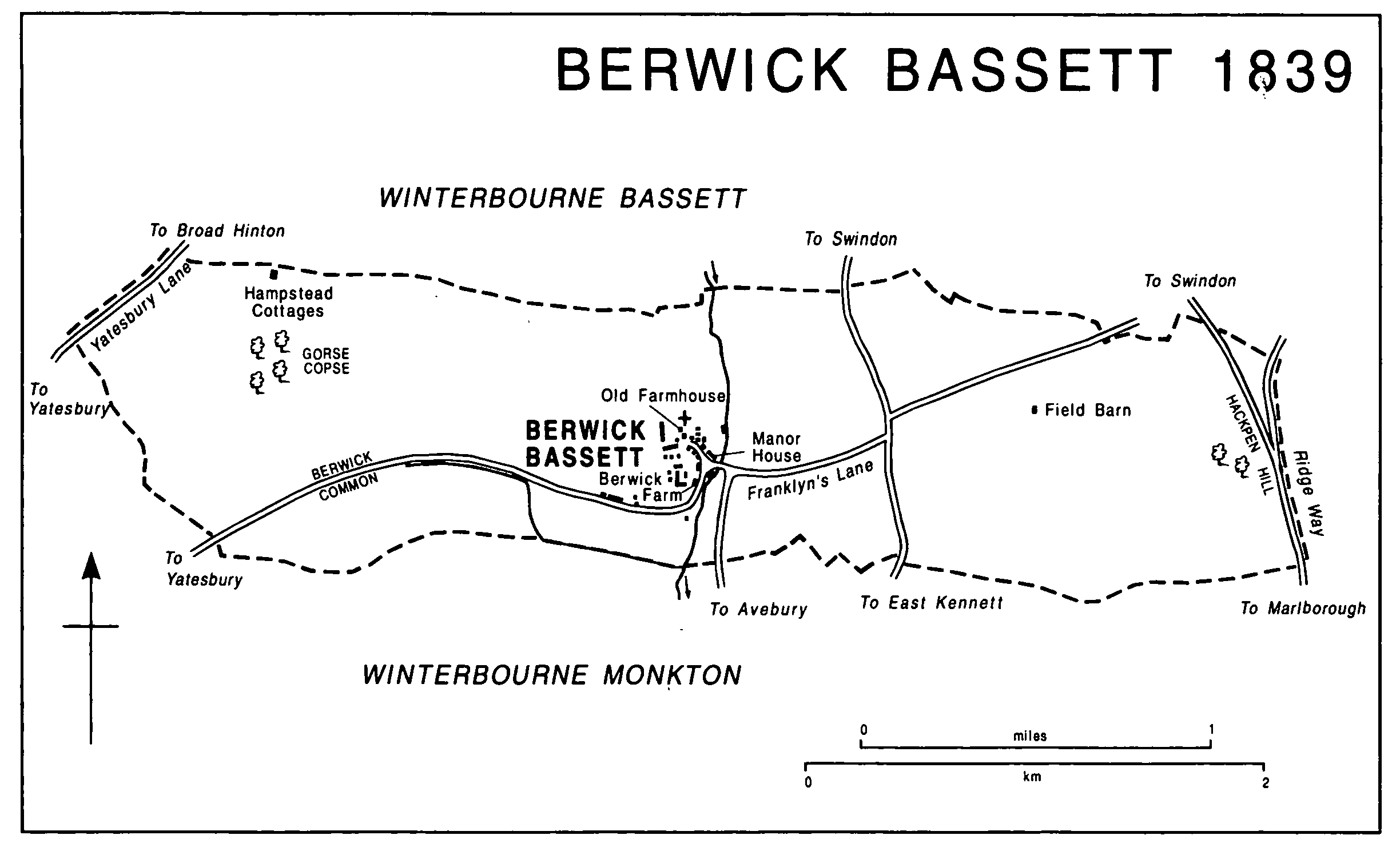
Berwick Bassett 1839
The Crown's interest in the manor was held by Queen Isabel, (fn. 50) and was presumably resumed on her defeat in 1330. Its estate in Berwick Bassett was in the keeping of Gilbert of Berwick (d. 1361) in 1331, (fn. 51) and probably before 1338 was granted to him in fee. The estate passed to Gilbert's daughter Agnes and her husband John de la Roches (fn. 52) (probably d. by 1376). (fn. 53) It descended to the Rocheses' son Sir John (d. 1400), (fn. 54) whose estates were held for life by his relict William and divided at her death in 1410 between his daughter Elizabeth, the wife of (Sir) Walter Beauchamp (d. 1430), and his grandson (Sir) John Baynton. (fn. 55) The estate at Berwick Bassett was apparently assigned to Elizabeth and was held at his death in 1457 by her son Sir William Beauchamp (from 1449 Lord St. Amand). (fn. 56) Sir William's relict Elizabeth, Baroness St. Amand, later the wife of Sir Roger Tocotes, held it until her death in 1491, when it passed to Sir William's son Sir Richard Beauchamp (Lord St. Amand from 1491). (fn. 57) At Richard's death in 1508 it probably reverted, with Roches manor in Bromham, to Sir John Baynton's grandson John Baynton (d. 1516), whose son Sir Edward held an estate in Berwick Bassett at his death in 1544. Sir Edward's son Andrew (fn. 58) sold the estate in 1557 to John Goddard and John's son Thomas (fn. 59) (d. 1581). Thomas's son John (fn. 60) (d. 1635) settled it in 1615 on the marriage of his son Edward (d. 1625), and it passed from Edward's relict Anne (fl. 1635) to their son John (fn. 61) (d. 1688), who devised it to his daughters Mary, Susanna, later the wife of Caleb Bailey, and Hannah or Anna Goldney, later the wife of Robert Maundrell, in common. Mary had conveyed her interest to her sisters by 1690, (fn. 62) and in 1708 the Maundrells conveyed theirs to Caleb Bailey. (fn. 63)
Stanley abbey's estate in Berwick Bassett passed to the Crown on the dissolution of the abbey in 1536, and in that year it was granted to Edward Seymour, (fn. 64) Viscount Beauchamp (cr. earl of Hertford 1537, duke of Somerset 1547). (fn. 65) In 1547 Seymour gave it back to the Crown in an exchange, (fn. 66) and in 1560 the Crown granted it to Thomas Powell and Elizabeth, the wife of Cuthbert Vaughan. (fn. 67) About 1562 Elizabeth, to whom Powell quitclaimed his interest in 1560, and Cuthbert conveyed the estate to Thomas Saunders alias Mills, (fn. 68) who gave it to his son Thomas c. 1568. (fn. 69) It again passed to the Crown on the younger Thomas's attainder in 1586 and was granted in 1588 to Richard Mompesson, (fn. 70) who sold it in 1590 to Walter Dunche (fn. 71) (d. 1594). Dunche's son William (fn. 72) sold it in 1633 to John Popham (d. 1636) and John's wife Mary, who survived her husband. John's heir was his brother Alexander Popham (fn. 73) (d. 1669) whose son George (d. 1687) owned the estate in 1675. George's son John (fn. 74) sold it to Caleb Bailey in 1709. (fn. 75)
Bailey (d. 1749) devised the whole manor of Berwick Bassett to his cousin Giles Bailey (fl. 1753) and Giles's issue, with reversion to Thomas Nalder, John Nalder, Ambrose Lanfear, and Elizabeth Mace. (fn. 76) Giles had evidently died without issue by 1767. (fn. 77) By will proved 1756 Thomas Nalder devised his interest to John (fn. 78) (will proved 1768), (fn. 79) who bought Elizabeth Mace's interest in 1762 and was succeeded by his son John. (fn. 80) The younger John Nalder and Thomas Lanfear owned the manor in 1767, (fn. 81) and by 1814 Nalder had acquired Lanfear's interest. (fn. 82) Nalder (d. 1821) (fn. 83) was succeeded by his son John (d. 1832), whose daughters Mary, Elizabeth, Sarah, and Martha inherited Berwick Bassett manor as tenants in common. Mary, wife of Henry Stratton, Elizabeth, wife of Robert Cooper, and Sarah, wife of Robert Gibbons, shared Martha's interest after her death in 1837, (fn. 84) and they or their heirs or trustees sold the manor in 1875 to Sir Henry Meux, Bt. (d. 1883). The manor passed to Meux's son Sir Henry Meux, Bt. (d. 1900), whose relict Valerie sold the land as Manor farm, c. 720 a., in 1909 (fn. 85) to F. G. Smyth (d. 1927). In 1939 Smyth's son F. W. L. Smyth sold the farm to R. H. Glyn, from 1942 Sir Richard Glyn, Bt., who sold it in 1951 to Hosier Estates. In 1965 it was bought from Hosier Estates as a farm of 760 a. by Mr. D. F. T. White, who in 1973 conveyed it to his son Mr. D. G. White, the owner in 1994. (fn. 86)
Its position near the church and its unusual plan suggest that the Old Farmhouse was used by priests serving the church, (fn. 87) but the house is more likely to have been the principal one on the Goddards' part of Berwick Bassett manor. It has a long east-west range of c. 1500 with walls of stone on the ground floor and of timber framing above. (fn. 88) No wall of so early a date survives on the ground floor inside, but a 16th-century timber screen divides the western third from the rest. On the first floor, which was open to the roof, there were three rooms each with a central arch-braced truss. Original fireplaces survive in the east and west gable walls on the ground floor, and there were fireplaces above them on the first floor, but no provision appears to have been made for heating the central rooms. There were north and south doorways immediately east of the screen; a south porch was incorporated in 19th-century additions. East of the porch there is a doorway which may have led to the original staircase, and opposite that doorway, on the north side of the house, stands a small wing with a jettied upper floor. Another wing, to the south-west, was built in the 19th century and, presumably when that wing was built, a doorway and a window were taken from the house to Vastern Manor in Wootton Bassett. (fn. 89)
The Manor (formerly Manor House), probably the 'fair dwelling house' recorded on George Popham's portion of Berwick Bassett manor in 1675, (fn. 90) comprises two stone ranges. An older north-west and south-east range is of c. 1600 and has at each end an external stack and a large ground-floor room; between those two rooms there was a smaller, unheated, room. The range returns to the south-east, forming an entrance hall which is joined to a long early 17th-century east-west range. The eastern end of the later range may originally have provided service rooms; it has many blocked windows and in 1994 was used partly as stables. The house was apparently lived in by Caleb Bailey in 1728. (fn. 91)
An estate in Berwick Bassett which was the origin of BERWICK farm was evidently held by the Templars and may already have been held by them when, before 1172, Adam de Port gave 1 yardland there to them. (fn. 92) The estate presumably passed with Temple Rockley manor in Preshute to the Hospitallers and after the Dissolution to members of the Baynton family, and it descended with the manor from 1595 to 1754. (fn. 93) In 1595 Henry Baynton sold it to Thomas Hutchins, (fn. 94) at whose death in 1607 it passed to Thomas Baskerville, (fn. 95) and from 1614 it descended with Winterbourne Bassett manor. From Baskerville (d. 1621) it passed in turn to his son Francis (d. before 1685), Francis's son Thomas (fl. 1707), Thomas's son Richard (d. 1739), and Richard's grandson Thomas Baskerville. (fn. 96) In 1754 it was sold by Thomas to trustees of Charles Lennox, duke of Richmond (fn. 97) (d. 1750), and in 1760 was held by Richmond's daughter Georgiana and her husband Henry Fox (cr. Baron Holland 1763, d. 1774). (fn. 98) Berwick farm descended, still with Winterbourne Bassett manor, in the direct line to Stephen, Lord Holland (d. 1774), Henry, Lord Holland (d. 1840), and Henry, Lord Holland (d. 1859), who devised the farm, 529 a. in 1843, to his relict Mary (d. 1889). Mary devised it to her husband's nephew Leopold Powys (fn. 99) (d. 1893), from 1890 Leopold Fox-Powys. It passed to Leopold's brother Thomas Powys, Lord Lilford (d. 1896), and to Thomas's son John, Lord Lilford, (fn. 100) who in 1902 sold it to James Horton (d. 1926). It presumably passed, as Winterbourne Bassett manor did, to James's son John and by sale in 1938 to the Gaunts Estate Company, which held it on behalf of Sir Richard Glyn, Bt. In 1951 Sir Richard sold Berwick (later Berwick House) farm, 419 a., and a further 155 a., part of Whyr farm based in Winterbourne Bassett, to Hosier Estates, which sold those lands in 1964. With the rest of Whyr farm the 155 a. was bought in 1964 by Mrs. D. King and in 1970 by Mr. M. R. Young, the owner in 1994. Berwick House farm was bought in 1964 by Cyril Humphreys, in 1968 by R. Stewart Hunt, and in 1982 by Mr. Jonathan Powell, who owned 420 a. in the parish in 1995. (fn. 101)
Tithes from Berwick Bassett were presumably among the possessions of Calne church when it was given to Salisbury cathedral in 1091 and when, no later than 1116, its estate was used to endow a prebend in the cathedral. (fn. 102) Between c. 1199 and 1221 the tithes were held by the rector of Winterbourne Bassett for 2s. a year paid to the prebendary. In 1221 they were confirmed as part of the PREBENDAL estate in Berwick Bassett. (fn. 103) Between 1220 and 1227 the estate passed to the treasurer of the cathedral and in 1841 to the Ecclesiastical Commissioners. (fn. 104) In 1843, when the estate included 46 a., the tithes were valued at £305 and commuted. (fn. 105) In 1874 the land was transferred to the united benefice of Winterbourne Monkton with Berwick Bassett. (fn. 106)
ECONOMIC HISTORY
In the Middle Ages Berwick Bassett almost certainly had extensive areas of open field east and west of the village with, beyond them, commonable pastures on Hackpen Hill to the east and on gently sloping downland to the west. There may have been 800-900 a. of open fields, and Hackpen Hill was presumably rough pasture for sheep. (fn. 107) The land was almost certainly worked from farmsteads in the village, and there is no evidence that the land of any estate was confined to either half of the parish.
In 1271 the demesne of Berwick Bassett manor included 250 a. of arable, 6 a. of meadow, and pasture for 24 oxen and 6 ewes. (fn. 108) In 1281 there was said to be grazing for 56 oxen and 250 sheep. Carrying services on the demesne were then valued at 4s., ploughing works at 12d. (fn. 109) About 1328 the demesne was evidently divided into two portions. (fn. 110)
In the earlier 16th century the two areas of open field were called East field and West field. The demesne of Lord Hertford's estate then included a nominal 247 a. in them, and his four copyholders had a nominal 204 a. Both the demesne and the copyholds included grazing rights on a pasture called West leaze and on Hackpen Hill. The copyholders could feed 460 sheep; 10 a. of a cow down, presumably in the west, provided several pasture for the demesne cattle from 2 February to 11 November. (fn. 111)
Much of Berwick Bassett's land was inclosed between the earlier 16th century and 1728, evidently before 1675. (fn. 112) In 1728 the commonable land was East field, 412 a., which extended from the head stream to Hackpen Hill, West field, 80 a. west of the village, a common of 5 a. including the green and extending north and south along the stream, and a common of 25 a. consisting of the track west of the village which widened in the extreme west. Some of East field lay in very large pieces: one was of 81 a., two were of c. 50 a., and three were of 13-17 a. East of East field Hackpen Hill, 157 a., had been made several by 1675, and in 1728 there was 15 a. of inclosed meadows between part of East field and the stream and there was 68 a. of inclosed arable north of Franklyn's Lane. West of the village there was c. 630 a. of arable and pasture in closes, including c. 100 a. north and south of the village and, in the extreme west, 55 a. of what were called common grounds. Some of the closes suggest that part of West field had lain in large pieces before it was inclosed. (fn. 113)
There may have been a large farm on each of the three principal estates in Berwick Bassett in the 17th century. In 1635 the estate owned by the Goddards was a single farm with land in the open fields, what was probably a 47-a. close of arable north of Franklyn's Lane, 95 a. of inclosed pastures, 67 a. of inclosed meadows, and feeding in common for 160 sheep, 16 cattle, and 3 horses. (fn. 114) In 1675 the demesne farm owned by the Pophams (formerly Lord Hertford's) lay entirely east of the village; it included the whole of Hackpen Hill as several pasture, 12 a. of pas ture elsewhere, and 200 a. of arable, of which most lay in three large pieces. (fn. 115) Those two farms were merged, probably in or soon after 1709. (fn. 116) In 1728 the combined farm, later Manor farm, had 651 a. including Hackpen Hill, 241 a. in East field including the three largest pieces, 19 a. in West field, 97 a. of arable in closes, and 131 a. of pasture in closes; it was worked mainly from the buildings immediately south of the church. Berwick (later Berwick House) farm was then of 269 a. including 107 a. in East field, 29 a. in West field, 50 a. of arable in closes, and 82 a. of pasture in closes. There were two other farms worked from the village, one of 110 a. and a 45-a. copyhold of the Prebendal estate, both with buildings beside the track leading west from the village. Hampstead Farm was built in the north-west corner of the parish, perhaps soon after the land was inclosed, and in 1728 a compact, several, and mainly pasture farm of 123 a. was worked from it. In 1728 the land of other holdings, c. 130 a., may have been worked with the five farms. (fn. 117)
In 1728 many of the strips in the open fields were of less than 1 a. (fn. 118) It was noted c. 1760 that there was no set time for breaking the fields, and in 1761 the boundary marks had to be renewed. (fn. 119) Common husbandry was apparently ended in 1782 when it was agreed that lands would be exchanged and that the farmers would feed animals on only their own land, (fn. 120) and in the earlier 19th century the Prebendal estate's 23 a. of arable remained in 25 scattered parcels as vestiges of the open fields. (fn. 121) In the later 18th century Manor farm comprised 643 a., (fn. 122) in 1808 Hampstead farm 121 a., and in 1810 Berwick farm c. 400 a. (fn. 123)
In 1843 the parish included 787 a. of arable, c. 75 a. of meadow, and c. 490 a. of pasture. Manor farm, which lay chiefly east of the village, measured 727 a. including c. 390 a. of arable, Hackpen Hill, 156 a., and 155 a. of meadow and pasture. Berwick farm, c. 448 a., lay chiefly west of the village and was two thirds arable and a third grassland. The farmstead of Hampstead farm had been converted to cottages and its lands, 149 a. including 67 a. of arable, were probably worked from Winterbourne Bassett as part of Whyr farm. (fn. 124)
Between 1843 and 1994 the size of Manor farm and of Berwick (Berwick House) farm, and the area of Berwick Bassett in Whyr farm, changed little. (fn. 125) By 1906 much of Manor farm had been converted to pasture, (fn. 126) and in 1951, when an attempt was being made to cultivate Hackpen Hill, the farm's 759 a. included c. 400 a. of grassland. (fn. 127) In 1994 wheat was grown on c. 400 a. and there was a dairy herd of 250. (fn. 128) Berwick farm had 130 a. of arable, mostly in the east half of the parish, in the 1930s, 260 a. of arable and 130 a. of pasture in 1951, when it supported a Friesian dairy herd. (fn. 129) It remained an arable and dairy farm in the later 20th century. (fn. 130) Whyr was a dairy farm in the 1920s and, apart from Gorse copse, its 155 a. in Berwick Bassett was grassland in the 1930s and 1951. The farm was wholly arable in the later 20th century. (fn. 131)
The parish was little wooded in the 18th century. (fn. 132) In 1843 it had 7 a. of woodland, of which 5 a. stood as Gorse copse to the west and 2 a. as a plantation on Hackpen Hill, (fn. 133) and in the late 20th century it had c. 20 a., including new plantations south of Gorse copse and on Hackpen Hill. (fn. 134)
There was a weaver in the parish in 1689. (fn. 135) There was a brick kiln on Hackpen Hill in 1828, (fn. 136) and in the 1880s there was also a brickyard. Both had been closed by 1899. (fn. 137)
LOCAL GOVERNMENT
The right to hold a court and a view of frankpledge passed with Stanley abbey's portion of Berwick Bassett manor. (fn. 138) Records of a manor court and view survive for 1737, 1750, 1761, 1783, 1814, and 1835. A tithingman was elected and a jury presented. Most presentments concerned property needing repair, and in 1761 the lack of covers for three wells was reported. In 1835 the tithingman was required to provide a set of hand-bolts. No tenurial business was recorded. (fn. 139)
In 1775-6 the parish spent £29 on poor relief. In 1802-3, when the poor rate was a little above the average for the hundred, £111 was spent, 9 people received occasional relief, and 11 adults and 23 children received permanent relief. (fn. 140) Expenditure reached a peak of £207 in 1814, although the numbers relieved were similar to those in proximate years when costs were lower. Between 1815 and 1835 spending on the poor fluctuated; it was highest in 1817 at £172 and lowest in 1827 at £91. (fn. 141) Berwick Bassett became part of Marlborough poor-law union in 1835, (fn. 142) of Kennet district in 1974. (fn. 143)
CHURCH
Berwick Bassett church was built between c. 1199 and 1221. It was disputed between the rector of Winterbourne Bassett, whose church the inhabitants of Berwick Bassett attended until theirs was built, and the prebendary of Calne, who owned the tithes arising in Berwick Bassett and may have built Berwick Bassett church. The dispute was resolved in the prebendary's favour, (fn. 144) and provision for Berwick Bassett church to be served was made until 1841 by the treasurer of Salisbury cathedral, to whose dignity the prebend of Calne was annexed from between 1220 and 1227, and from 1841 to 1854 by the bishop of Salisbury. (fn. 145) In the early 15th century, and perhaps from when it was built, inhabitants of Berwick Bassett had rights to receive all sacraments in their church and to be buried in its graveyard. (fn. 146) In 1658 Berwick Bassett chapelry was detached from Calne and united to Winterbourne Monkton. (fn. 147) That union survived until c. 1662, (fn. 148) but, presumably about then, (fn. 149) Berwick Bassett again became a daughter church of Calne. It was separated from Calne in 1853-4 when the bishop of Salisbury licensed a clerk to a perpetual curacy of Berwick Bassett, (fn. 150) a living to which the Ecclesiastical Commissioners added a small endowment. (fn. 151) From 1865 to 1929 the curacy was united to Winterbourne Monkton vicarage, and from 1929 to 1951 instead to Winterbourne Bassett rectory; (fn. 152) it was added to the benefice of Avebury with Winterbourne Monkton in 1970, when the three parishes were united. (fn. 153) In 1975 that benefice and others were merged as Upper Kennet benefice. (fn. 154) Berwick Bassett church was declared redundant in 1972, (fn. 155) and passed in 1973 into the care of the Redundant Churches Fund (later the Churches Conservation Trust). (fn. 156)
The bishop of Salisbury was patron of the perpetual curacy (fn. 157) and of the united benefice created in 1865. (fn. 158) Magdelen College, Oxford, was patron of the benefice of Winterbourne Bassett with Berwick Bassett, (fn. 159) and from 1951 the bishop has been patron of Berwick Bassett and of the united benefices of which it has been part. (fn. 160)
In 1650 the curate of Berwick Bassett received a stipend of £30 from the lessee of the tithes of the parish, in the mid 18th century one of £40. (fn. 161) From 1853 the Ecclesiastical Commissioners, the owners of the tithe rent charge, gave an additional £12 a year to the curate; (fn. 162) in 1874 they gave part of their estate in Berwick Bassett, 46 a. and the tithe rent charge from that land, to the incumbent of the united benefice, and in 1880 they gave another part of their estate in Berwick Bassett, tithe rent charges totalling £232, to the incumbent. (fn. 163) Between 1920 and 1923 c. 20 a. was sold, and in 1995 the Salisbury diocesan board of finance owned 8 a. (fn. 164) Other land and the tithe rent charges given in 1874 and 1880 were transferred to other livings in 1929. (fn. 165) There was a house for the chaplain of Berwick Bassett in 1405, (fn. 166) and in the 16th century priests may have lived in the Old Farmhouse. (fn. 167) In 1650 there was evidently no house for the curate. (fn. 168) A new house was completed in or soon after 1864 for the incumbent of the benefice of Winterbourne Monkton with Berwick Bassett; it was built halfway between the two villages and was sold in 1940. (fn. 169)
In 1331 Gilbert of Berwick gave the income from 1 yardland to provide daily masses in Berwick Bassett church. (fn. 170) An obligation on the treasurer of Salisbury cathedral to provide two processional candles and a candle for the high altar was not met in 1405 or 1409, and a lamp, which should have been provided by the rector of Winterbourne Bassett in return for 2 a. in Berwick Bassett, was also missing in 1409. (fn. 171) Before the Reformation the churchwardens of Berwick Bassett held 1 a. for a lamp. (fn. 172)
The church may not have been well served by the chaplains and curates appointed by the treasurer or the vicar of Calne. In 1633 it contained no book other than a Bible and, perhaps, the Thirty-Nine Articles; having no prayer book, the churchwardens claimed that they did not know what other books were required. (fn. 173) Woolston Miller, who served the church in 1650, and Francis Hubert, who served it c. 1662, were expelled, presumably for failing to conform. (fn. 174) In 1783 a curate who lived at Wroughton served Berwick Bassett, Broad Hinton, and Wroughton churches, (fn. 175) but in 1829 Berwick Bassett may have had its own curate. (fn. 176) In 1864 the perpetual curate, who lived in the schoolhouse while the new glebe house was being built, held two services each Sunday and additional services on Ash Wednesday, on Wednesdays and Fridays in Lent, and on Good Friday, Ascension day, and Christmas day; communion was celebrated on Christmas day, Easter day, Whit Sunday, and the first Sunday of each month. The average congregation at the Sunday services was said to exceed the parish's population, and there were 20 communicants. (fn. 177) From 1929 the incumbent did not live in the parish; (fn. 178) between 1952 and 1970 Berwick Bassett was held in plurality with Avebury with Winterbourne Monkton, (fn. 179) and from 1975 was served by a team ministry. (fn. 180)
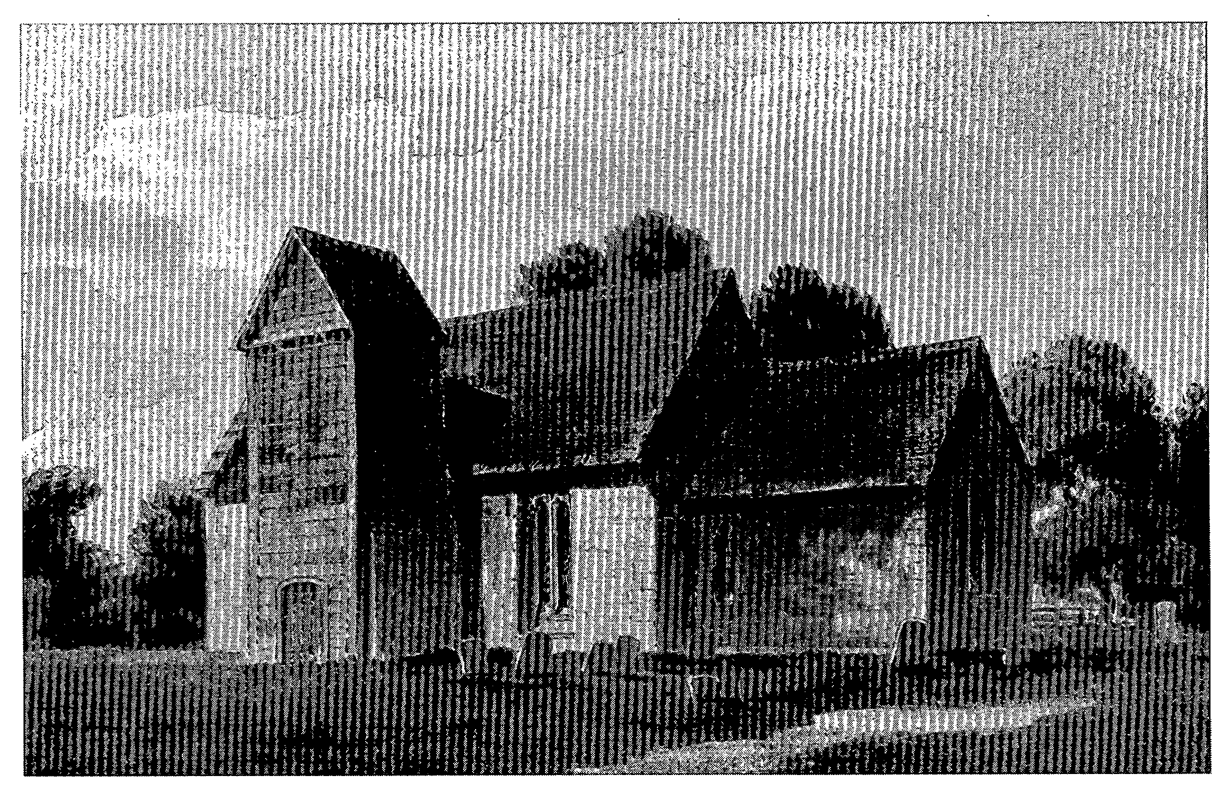
St. Nicholas's Church from the south-east in 1807
The church of ST. NICHOLAS, so called in 1331, (fn. 181) is built of rubble and red brick with freestone dressings and has a chancel and a nave with a south porch surmounted by a tower. The present chancel was standing in the 13th century, although facing with brick in the 18th century and partial rebuilding in the 19th have obscured most 13th-century features. The nave was rebuilt in the 14th century and given new windows in the 15th. In the 18th century the porch and the tower were built, or rebuilt, mainly in wood. In 1857, under the direction of T. H. Wyatt, parts of the walling of both the chancel and the nave were rebuilt, a new chancel arch was built, and the tower was replaced in stone. A vestry, built in 1857 on the north side of the chancel, was standing in 1912 but not in 1994. A 13th-century font and a 15thcentury rood screen, which formerly had a loft, (fn. 182) remain in the church.
Plate weighing 1 oz. was confiscated in 1553, and a chalice of 7 oz. was left in the church. A chalice and a paten given in 1775 were still held for the church in 1994. (fn. 183)
There were three bells in the church in 1553. A bell of 1605, one of 1663 cast by Roger Purdue, and one of 1694 by Robert Cor hung there in 1994. (fn. 184)
Registers of baptisms and marriages survive from 1674, of burials from 1676. (fn. 185)
NONCONFORMITY
There were presumably nonconformists at Berwick Bassett in the 1660s, when Francis Hubert was ejected from the living (fn. 186) and two ministers ejected from other Wiltshire livings preached there. (fn. 187) Caleb Bailey (d. 1749), the lord of Berwick Bassett manor, bequeathed money to train dissenting ministers and to maintain local meeting houses, (fn. 188) but no dissenters' meeting house is recorded in the parish before 1819, when a room was licensed for Independents. In 1834 a house was licensed for meetings of Primitive Methodists, and another meeting house was licensed in 1848. (fn. 189) In 1864 there was no nonconformist place of worship although there were 10 dissenters. (fn. 190)
EDUCATION
Henry Webb (d. 1766) bequeathed the income from £350 to pay for poor children of Berwick Bassett to be taught. (fn. 191) In 1818 the charity school had 10 pupils; (fn. 192) in 1833, when the endowment yielded £13, it had 28. (fn. 193) In 1847 a National school, incorporating a teacher's house, was built south of the church; it received the income from Webb's charity, £11 4s. in 1906. (fn. 194) The school had 15 pupils in 1871 (fn. 195) and was closed in 1897 because there were too few pupils for it to be kept open. (fn. 196) It was reopened and in 1907 average attendance was 22. Average attendance remained c. 20 until the school's final closure in 1922. (fn. 197)
CHARITY FOR THE POOR
Under the will of Sarah Hawkins proved 1856 £179 was invested for the poor of the parish. In the later 19th century and the earlier 20th the charity's income was used to buy coal: £6 13s. 6d. was spent in 1907. In 1951 a similar sum was distributed in cash, (fn. 198) and in the earlier 1990s no distribution was made. (fn. 199)