A History of the County of Wiltshire: Volume 18. Originally published by Boydell & Brewer for Victoria County History, Woodbridge, 2011.
This free content was digitised by double rekeying. All rights reserved.
'Historic Parishes - Ashton Keynes', in A History of the County of Wiltshire: Volume 18, ed. Virginia Bainbridge (Woodbridge, 2011), British History Online https://www.british-history.ac.uk/vch/wilts/vol18/109-140 [accessed 30 April 2025].
'Historic Parishes - Ashton Keynes', in A History of the County of Wiltshire: Volume 18. Edited by Virginia Bainbridge (Woodbridge, 2011), British History Online, accessed April 30, 2025, https://www.british-history.ac.uk/vch/wilts/vol18/109-140.
"Historic Parishes - Ashton Keynes". A History of the County of Wiltshire: Volume 18. Ed. Virginia Bainbridge (Woodbridge, 2011), British History Online. Web. 30 April 2025. https://www.british-history.ac.uk/vch/wilts/vol18/109-140.
In this section
ASHTON KEYNES
ASHTON KEYNES village stands 8 km. south of Cirencester (Glos.), 5.5 km. west of Cricklade, and 14 km. north-west of the centre of Swindon. (fn. 1) The affix Keynes, the surname of the family which held the Rectory estate in the later 13th century, (fn. 2) is first recorded in 1490. (fn. 3) The parish is flat land drained by the upper Thames and is notable for the gravel extraction which has taken place there since the Second World War; in 2010 more than half the surface of the parish consisted of water-filled pits, now part of the Cotswold Water Park, a tourist attraction.
In the Middle Ages both the parish and manor of Ashton Keynes included the land of Leigh. Churches existed at Ashton Keynes by the 12th century and at Leigh by the 13th, the latter a chapel of the former. In 1548, however, holdings of land worked from farmsteads at Leigh were severed from Ashton Keynes manor and held as the manor of Leigh, and from the 16th century or earlier Leigh church had its own wardens. (fn. 4) In 1884 Leigh became a separate civil parish. (fn. 5)
Some Leigh farmsteads included land in Ashton Keynes, (fn. 6) and the vestry of Ashton Keynes allowed the rates levied on this land to be paid to Leigh. In 1778, on the eve of inclosure, most of this land was evidently commonable, and it was replaced by c. 120 a. of allotments in the south-east corner of Ashton Keynes. But 16 a. of land paying rates to Leigh had been inclosed before 1778; this became part of Leigh parish and lay as four islands within Ashton Keynes parish. The 120 a. or so allotted in 1778 separated a 16-a. island of Ashton Keynes from the main parish. (fn. 7)
A similar intermingling of lands existed in the Middle Ages with the manor of Shorncote (Glos. from 1896) (fn. 8) Tithes and rates were paid to Shorncote on certain lands in Ashton Keynes which later became part of Shorncote parish. At inclosure, to rationalize holdings and compensate for the loss of commonable land, Shorncote owners were allotted land in the northwest corner of Ashton Keynes and this was transferred to the adjoining Shorncote parish. (fn. 9) East of Ashton Keynes village, 16 a. in two fields, evidently inclosed before 1778, remained as islands of Shorncote parish surrounded by Ashton Keynes. (fn. 10)
Until 1778 the men of Ashton Keynes shared common pastures with the men of Somerford Keynes and Minety, and in that year, as Ashton Keynes's southeast and north-west boundaries with Leigh and Shorncote were revised, its west boundary with Somerford Keynes and Minety was redefined. (fn. 11) From 1778 Ashton Keynes parish measured 2,799 a. (1,133 ha.). In or about 1884 all the islands of land were transferred to the parishes which surrounded them, and Ashton Keynes parish increased in area to 1,137 ha. (2,810 a.). (fn. 12) Of the 120 a. or so allotted in 1778 to those paying rates to Leigh, 34 a. was transferred from Leigh parish to Ashton Keynes in 1984, thus increasing Ashton Keynes parish to 1,151 ha. (2,844 a.). (fn. 13)
Boundaries
Much of Ashton Keynes's boundary followed watercourses. On the north-east, the long boundary with South Cerney (Glos.) followed a head stream of the Thames called Shire ditch and had been set by 999. (fn. 14) On the south-east the boundary with Leigh followed the Thames for c. 3 km.; (fn. 15) after the boundary revisions of 1778 and c. 1884 it followed it for c. 1.5 km. and was otherwise irregular. Most of the irregularities were removed by the boundary revision of 1984, from when the boundary with Leigh followed the Thames for c. 2 km. On the south the boundary with Leigh followed a tributary of the Thames, Swill brook, for c. 500 m. (fn. 16)
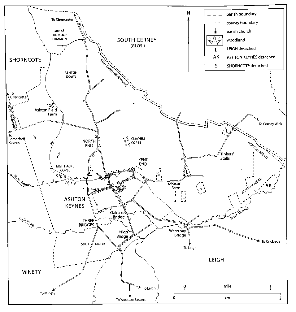
MAP 11. Ashton Keynes parish in 1875, showing detached parts of Shorncote (Glos.) and Leigh. More than half the surface of the parish now consists of water-filled pits left by intensive gravel extraction.
Although Ashton Keynes may have had a recognized boundary on the south-west with Minety and on the west with Somerford Keynes, (fn. 17) in both cases the boundary ran across common pasture shared with its neighbours and was redefined in 1778; (fn. 18) the new lines of the boundary are straight. Until 1778 the northern part of the boundary with Somerford Keynes followed a north–south road. A small section still followed the road after the boundary with Shorncote was revised in that year; the rest was diverted north-eastwards, became a boundary with Shorncote, and followed irregular field boundaries to a watercourse which runs into Shire ditch. A stone stood beside that watercourse to mark where Ashton Keynes, Shorncote, and Siddington (Glos.) met, and another, called Shire stone, stood beside Shire ditch where Ashton Keynes, South Cerney, and Siddington met. (fn. 19)
Landscape
The gravel quarried at Ashton Keynes had been deposited on clay by the Thames and its tributaries and head streams, and covered most of the parish. Near the watercourses alluvium overlies the gravel, and between two of the watercourses there are two low clay ridges. The land lies at c. 85 m., slopes gently downwards from west to east, and is almost flat. The two ridges rise in the west part of the parish: Ashton down, to the north, reaches 105 m., and the second, between Ashton down and the village, lies at a little above 90 m. The Thames enters the parish from the west at c. 86 m. and leaves the parish boundary on the east at c. 83 m. Swill brook, a southern tributary, crosses the parish, and there are two northern head streams: Shire ditch (otherwise called Wick water), which marks the parish boundary, and a watercourse along the west side of Ashton down. (fn. 20)
Ashton Keynes had large open fields and commonable pastures and, especially beside Shire ditch and the Thames east of its confluence with Swill brook, was rich in meadow land. Sheep-and-corn husbandry was practised in the parish, and cattle rearing and dairy farming were favoured by the extensive low-lying grassland. (fn. 21)
From c. 1960 much farmland north, east and west of Ashton Keynes village has been sacrificed to gravel extraction, and the resulting water-filled pits have been managed as lakes for recreation and wildlife. (fn. 22) In 2005 lakes covered most of the 1,022 ha. (2,525 a.) of Ashton Keynes and some were used for waterskiing and fishing. (fn. 23)
Communications
No major road has crossed the parish. West of Ashton Down, a north–south Romano-British trackway served the settlement there, and probably connected the area with Roman Corinium, later Cirencester. (fn. 24) The village was linked by radiating lanes to Cirencester, Cerney Wick (in South Cerney), Cricklade, Leigh, Minety, Somerford Keynes, and Shorncote before the inclosure of common lands in 1778, when the pattern was changed. (fn. 25)
The two oldest parts of Ashton Keynes village were linked to Cirencester by north–south lanes which converged at the north end of the village. The western branch may be the older and have been superseded by the eastern, called High road in 2005, which serves the more populous part of the village; as part of a Cirencester and Wootton Bassett road the eastern was turnpiked in 1810 and disturnpiked in 1864. (fn. 26) At inclosure in 1778 Gosditch, an east–west street in the village, was extended westwards to join the western branch, which was improved from that junction south to the crossing of Swill brook called Three Bridges; new straight roads were then made from Three Bridges south-eastwards to the Wootton Bassett road and southwards to the Ashton Keynes to Minety lane. (fn. 27) Since the late 20th century north–south through traffic has been directed to bypass the more populous parts of Ashton Keynes village by using the western branch of the old road, the improved road between the west end of Gosditch and Three Bridges, and the new southeasterly road from Three Bridges.
The lane which linked Ashton Keynes and Somerford Keynes may have run close to the house lived in by the lord of Ashton Keynes manor, north of which there lay a small park in the 18th century. (fn. 28) In 1778 it was replaced by a new road which, along two straight sections, linked Somerford Keynes to the Cirencester road at North End. The road which marked part of Ashton Keynes's boundary with Somerford Keynes, Spratsgate Lane, linked Cirencester and Minety, and from 1778 that road and the new Somerford Keynes road probably took the traffic between Ashton Keynes and Shorncote. (fn. 29)
At the south end of Ashton Keynes village the lanes from Cricklade and Minety ran across common pastures until inclosure in 1778, when they were set out mainly on new courses. The road from Cricklade, which crossed the Thames on Waterhay bridge, was evidently remade as three straight sections, including one running south-west to join High Road at the south end of the village; that from Minety was diverted to the new road running south from Three Bridges. East of Ashton Keynes village that part of the Cerney Wick road in which there were several right-angled corners may also have been set out on a new course in 1778. (fn. 30) Ashton Keynes and Leigh are linked by lanes which diverge from the Cricklade and Wootton Bassett roads.
To exclude lorries from most of Ashton Keynes village, to improve access to the gravel pits and to the country park, a new road, Spine Road (East), was opened in 1971. (fn. 31) It linked the London-Gloucester road in Latton parish to the Cirencester and Wootton Bassett road at North End. West of North End the Somerford Keynes road was improved (fn. 32) and given the name Spine Road (West), and to serve the gravel pits and a factory in the east corner of Ashton Keynes parish a new north–south road, given the name Fridays Ham Lane, was built along the course of an old lane between Spine Road (East) and the Cerney Wick road. (fn. 33)
Population
There were 207 poll-tax payers at Ashton Keynes in 1377, (fn. 34) and an adult population of c. 300 in 1676. (fn. 35) At the 1801 census the population numbered 764. It rose at each successive census until 1861, when it numbered 1,070; thereafter it fell at each census until 1921, when it numbered 744. It increased again as new houses were built in the village from the 1920s, to 774 by 1931, to 959 by 1951, (fn. 36) and to 987 by 1971. Between 1971 and 1991 the population rose by 42 per cent to 1,399, and in 2001 it stood at 1,420. (fn. 37)
SETTLEMENT
Early Settlement
Archaeological investigation in advance of gravel extraction has recovered widespread evidence of prehistoric and later farmsteads and settlements within the parish. West of Ashton Down, and lying partly in Shorncote (Glos.) a multi-period farm was occupied from the Early Bronze Age through the Iron Age and Romano-British periods. It was modified and reconstructed from c. 300 when new masonry-footed buildings and a large enclosing ditch were constructed; a further reordering took place probably in the 7th century with the building of post-built halls and sunken huts. (fn. 38) At Cleveland farm an extensive high-status Iron Age settlement, comparable in status with nearby oppida, continued into the Roman period, was reconstructed c. 300, and did not fall out of use until c. 500 or later. (fn. 39) Other Iron Age or Romano-British farmsteads have been discovered between Rixon Gate and Waterhay; south-east of Ashton Down; and at Ash Covert, on the boundary with Somerford Keynes. (fn. 40) Evidence for field systems, trackways, enclosures and the ring ditches of former barrows is scattered across the parish, and most such features, although undated, are of probable prehistoric or Roman date. (fn. 41) All are not necessarily contemporary, and considerable settlement shift, abandonment and reconstruction may have occurred here, as elsewhere in the fertile upper Thames valley, as a result of river-flooding, tribal allegiance, and the Roman administration. (fn. 42) Although few finds of later Anglo-Saxon date have been made, (fn. 43) the Domesday assessment of 36 tenant households (including Leigh) implies that the area of the later parish was well populated. (fn. 44)
Ashton Keynes Village
The medieval village had a complex polyfocal plan comprising at least four elements which have coalesced and have been extended to create the modern settlement. An early focus, indicated now by the position of the parish church, mill and Church Farm, lay close to the Thames crossing of an early north–south route. (fn. 45) There was already a water mill by 1086, (fn. 46) and this part of the village developed south of the site occupied by the church from the 12th century. The church may have been served at first by a rector, (fn. 47) and in the early Middle Ages the principal buildings of the Rectory estate probably stood on the site now occupied by Church farm, which later became the demesne farm of Ashton Keynes manor. (fn. 48)
A second, defensive, focus was created further east, in the area later known as Halls close. Here a moated ringwork, adjoining a sub-rectangular bailey and closes associated with it running south, has yielded tiles and pottery of early 12th–13th century date. (fn. 49) It may be the castle, described as at South Cerney (Glos.), which was captured by Stephen in 1139. (fn. 50) Its strategic importance must have declined thereafter, but it possibly continued in use as the demesne farmstead of the manor.
After Tewkesbury abbey (Glos.) acquired Ashton Keynes manor in c. 1102, (fn. 51) the abbey apparently replanned the settlement, which grew in the 12th century in two main parts. East of the present mill and along the north bank of the Thames, an east–west street lined with buildings developed, now Back Street and Church Walk, and this was intersected by an alternative north–south route, the present High Road. South west of the ringwork, the east–west lines of buildings along what is now Fore Street and Gosditch probably represent a more ambitious extension to the village plan. The effect of these developments, which may have included the digging of channels to bifurcate the river for water management, was to create a simple gridded street plan, perhaps with the unrealized intention of promoting a market where Gosditch broadens near its western end.
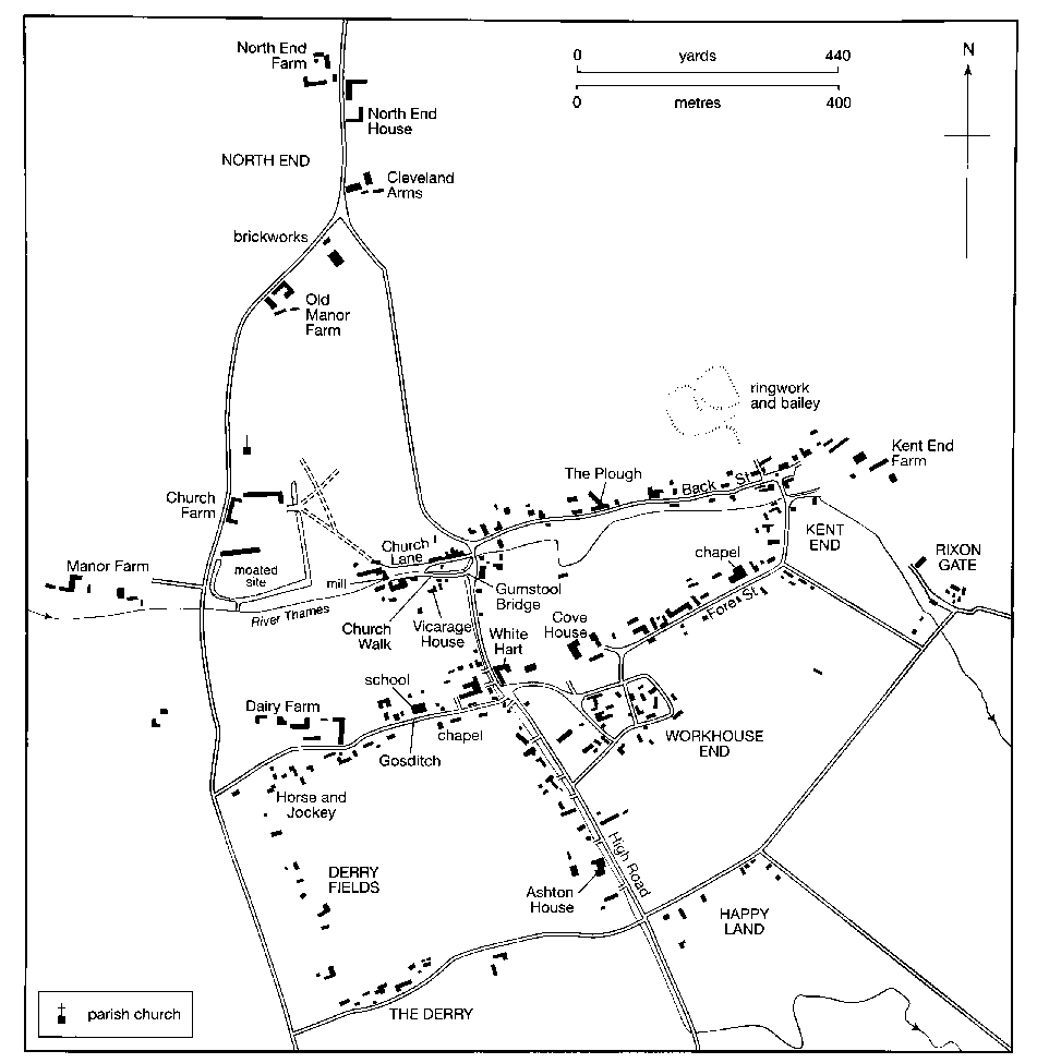
MAP 12. Ashton Keynes village in 1875. Settlement grew up around earthworks near Church farm and Kent End. Tewskesbury abbey re-planned the settlement along an east–west street, now Back Street and Church Walk, intersected by High Road. Fore Street and Gosditch probably represent an extension to the plan. Squatter settlements grew up on the outskirts.
Between the late 12th or early 13th century and the early 14th century a small manor, which was part of the Rectory estate, was held by members of the Sandford family and their descendants. The manor almost certainly included the buildings of Church Farm, standing on an unusually large rectangular moated site, which appears to have extended west of the present road, and by the 19th century was entered from the village. In the later 13th century the manor house was probably occupied by the Keynes family, which is remembered in the name of the parish. In the early 14th century Tewkesbury abbey, as the appropriator of Ashton Keynes church, proved its right to the small manor, (fn. 52) and by the 16th century the abbey had apparently merged the demesne of the small manor with the demesne of Ashton Keynes manor, of which it remained lord. Any buildings of the demesne farmstead of Ashton Keynes manor, which may have stood on the site of the ringwork, were abandoned and Church farm became the principal farmstead of the united demesne. In the 16th century the site of the ringwork was called Hall Close and was part of the demesne. (fn. 53) A large house was built as a manor house within a park north of the Thames near the church, probably c. 1714, and parts were converted to a farmhouse c. 1831. (fn. 54)
In the main part of the village the tenements held freely or customarily of Ashton Keynes manor evidently stood along the east–west streets. The village was populous, and the tenements were numerous; in 1604 there were c. 100 houses and cottages in the village. (fn. 55) The number of farms worked from buildings in the street almost certainly declined in the 17th and 18th centuries, (fn. 56) and in the 19th century and earlier 20th some of the houses were lived in by private residents and some, presumably incorporating workshops or shops, were used for trade or retail. (fn. 57) A new vicarage house was built in Church Walk in 1584. (fn. 58) In the 19th century a Nonconformist chapel and a school were built in Gosditch, a Nonconformist chapel and a manse were built in Fore Street, there were public houses in Gosditch and Back Lane, and small houses or cottages were built in all four parts of the east–west streets.
The earlier course of the Cirencester and Wootton Bassett road probably ran to the west of Ashton Keynes church and an eastern branch diverted from it to serve the village after its streets became lined with buildings, perhaps in the earlier 12th century. The eastern branch crossed both east–west streets and, because it was more used than the western branch, it became the main Cirencester and Wootton Bassett road until the late 20th century. Where it crossed the northern street, dividing it into Back Street and Church Walk, it was diverted eastwards to skirt the garden of the vicarage house built in 1584. In the 19th century an inn stood beside the main road near that junction, another inn stood where the road crossed the southern street, dividing it into Fore Street and Gosditch, and two smithies stood beside the road south of Fore Street and Gosditch. (fn. 59)
From the east end of Church Walk the Thames flows through the village in two courses, the first eastwards a little south of Back Street, and the second which became the main course, along the west side of High Road. The main course was altered as the village developed in the 17th, 18th, and 19th centuries: the river was channeled into a small canal and was bridged in many places, several large houses were built on the south side of Church Walk and the west side of High Road, and on the south side of Church Walk the vicarage house was largely rebuilt. Church Walk crosses the river on Gumstool bridge, which was rebuilt and lengthened in 1812. Also in 1812 a new bridge was made over the river in Church Walk (fn. 60) to improve pedestrian access between the church and the main part of the village; the footpath between the mill and the church was lined with trees by 1875. (fn. 61) The large houses on the west side of High Road, and some of their outbuildings, were approached by bridges across the canalized river; in the late 19th century there were four footbridges and eight bridges wide enough for a carriage or cart. South of Gosditch the road was apparently widened. In the later 19th century the house at the south end, Ashton House, had a small park on the east side of the road, and by then that part of the village had been gentrified. (fn. 62) The narrow bridge by which Gosditch crosses the river was rebuilt in 2005. (fn. 63)
Four crosses apparently stood in the south-east part of the village in the Middle Ages. One stands at each crossing of the east–west streets and the Cirencester road, and a third stands in Park Place off Fore Street. Each of those crosses is on a stepped base and is 14th- or 15th-century. (fn. 64) In 1812, when the bridges nearby were rebuilt, the cross at the Back Lane and Church Walk crossing was rebuilt on a site very near to its earlier one. (fn. 65) Blackwell cross, at the Fore Street and Gosditch crossing and so called in 1778, (fn. 66) was moved and restored in or soon after 1958. The fourth cross stands in the churchyard and was made in the late 19th century or early 20th from stones found in several buildings in the village and thought to have been parts of a former cross. The cross in the churchyard was rededicated as a war memorial in 1917. (fn. 67)
Buildings
The village buildings are typical of the
area. There is evidence of timber framing in the houses
built before the 17th century: three pairs of crucks in a
cottage at the west end of Back Street (fn. 68) are the only
medieval fabric known to have survived in the village.
The other oldest houses to survive were built very late
in the 16th century or in the early or mid 17th: they
include a house of one storey and a half with a central
chimney stack and now part of Dairy Farm in Gosditch,
a house on an L-plan adjoining the Grove in High
Road, a two-storeyed house now subsumed in Cove
House, and Mill House in Church Walk. Only Mill
House retains datable external features such as
mullioned windows. From the 17th century to the 19th
typical houses were built of coursed limestone rubble
with timber lintels. Roofs were covered with stone slates
or thatch. Little dressed stone was used and, until the
19th century, almost no brick. Even in the 19th century,
when they were made at North End, bricks were used
sparingly and mainly for chimney stacks.
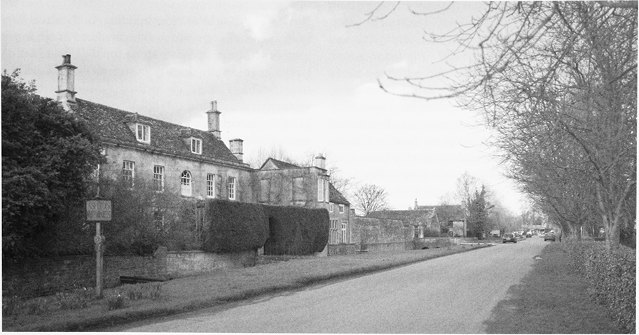
15. View of High Road looking north, showing the path of the Thames and the bridges across it to the houses on the west side.
The larger 18th-century houses in the village were built on what was apparently an established local pattern, with two storeys, attics, end stacks, and two or three rooms on each floor. Such houses include Brook House in Church Walk, Amcross Cottage in Fore Street, and, in High Road, the Long House, London House, and the Grove; the Grove has an outbuilding in which a 14th-century window has been reset. Cottages and smaller houses of the late 17th century or the 18th survive at Kent End, and a very small thatched cottage of one storey and attic survives at The Derry. Outside the village the larger houses built in the 18th century were of a standard local type. They include the farmhouses at Kent End farm, North End farm, and Rixon farm.
In the mid-late 19th century several villa-style houses were built in the village: they include Melton Lodge in Back Street (c. 1852–60), the manse (c. 1870s) in Fore Street, and Park House in Park Place which is notable for applied neo-classical detail. (fn. 69) Some 18th-century houses were altered to serve as inns and others were doubled in size, for example, a parallel range was added to a house in Gosditch and to Ashton Field farmhouse; a wing of new service rooms was added to Old Manor Farm; and Brook House was united to Brook Cottage by means of a linking range and given a detached coach house and stables.
Most 18th- and 19th-century buildings to survive are cottages of two storeys and of two or three bays. Those of the 19th century are taller, and of them the earlier ones are distinguished by stone voussoirs to segmental windows and the later ones by dressings or facades of ashlar. Many these cottages stand on sites apparently chosen at random. In some parts of the village dwellings may have been converted from outbuildings or workshops and in some cases one stands behind another. In the 20th century many private detached houses which replaced older buildings, or filled spaces between them, were built on a similar irregular pattern.
In the streets of the village, where the housing is largely undifferentiated, only a small proportion of the houses are of more than three bays. Some of the larger ones stand in High Road and there are others at the farmsteads on the periphery of the village. A number of buildings are of architectural interest, notably Cove House in Fore Street, Ashton House in High Road, the Congregational chapel and manse in Fore Street, and the 19th-century school in Gosditch. The village was designated a conservation area in 1974. The designated area was revised in 1994. (fn. 70)
Overall around 200 new houses were built in Ashton Keynes between c. 1920 and 2005, on new estates and on individual plots between older buildings. (fn. 71) There was also piecemeal conversion of non-domestic buildings to residential use. The houses built by Cricklade and Wootton Bassett Rural District Council in the early 1920s and late 1930s at Kent End, were in cottage-style, and those built in the late 1920s were of concrete blocks. (fn. 72) The houses built at The Mead in the late 1940s were of the Airey type, and those built in the early 1950s were of concrete blocks. (fn. 73) In the later 1960s the council built houses and bungalows with stuccoed fronts in Harris Road. From the 1960s on many houses were built by private speculators and the later ones were built of simulated stone in simulated traditional style. Development took place in Eastfield, the Lotts, and Milling Close in the late 1970s and early 1980s, and in Ashfield and Harris Road in the early 1990s. In Richmond Court, the houses built in the 1970s are in Scandinavian style, hung with tiles, and have open front gardens. In the 1980s and 1990s many small detached houses were built on individual plots, mostly of blocks of simulated stone and some dressed with brick. Culde-sacs were built behind the main streets: The Leaze and Richmond Court off Back Street in the 1960s and 1970s; Thames View off Park Place in the 1960s and Birch Glade in the 1990s; and Sadlers Field off Fore Street in the 1990s.
South-east of the church
The church and adjacent
moated manorial site and mill are approached from the
village by lanes on either side of the river. Church Lane
is the path running along the north bank of the Thames
parallel to Church Walk. Thatched buildings stood
beside the path in 1810. (fn. 74) An 18th-century cottage
survived in 2005 and three houses and a pair of cottages
from the 19th- or early 20th-century. (fn. 75)
In Church Walk, a short street, three large houses stand on the south bank of the Thames: the old vicarage house, Brook House, and Brook Cottage. The mill house stands at the west end, and a former outbuilding has been converted into another house. Little survives of the 16th-century vicarage house: stabling dates from the 18th century, and the house was much altered then and later. (fn. 76) Brook House is an 18th-century double-pile two-storeyed house with a two-bayed main front, which originally had a central doorway. Brook Cottage is a late 17th-century two-storeyed house with casement windows and timber lintels. Brook House has early 19th-century stabling, and the converted outbuilding is of the 18th or 19th century and may have been the stables of Brook Cottage. The Mill House dates to the late 16th or 17th century. The house was built to a high standard, suggesting the miller was wealthy. Two gabled units project north, each with a large chimney stack and in the 19th century the house stood attached to a long west range and to the mill, which spanned the river to the south. Milling ceased in c. 1900 and the mill was demolished by 1913. Afterwards the house was restored, (fn. 77) and it was enlarged in 1933–4. (fn. 78) J. Merrit Poulton designed a new south wing to match the existing building, which almost doubled the domestic accommodation and included a drawing room and a library. (fn. 79)
Back Street
Most older buildings in the street have
been altered. Exceptions are the former Plough inn, a
large house bearing a date stone for 1694, and Melton
Lodge, a mid-19th-century house set back from the
street. The Plough, a gentry residence of five
symmetrical bays and two tall storeys, has attic rooms
lit by dormers in a hipped roof. The entrance is to the
east of a central chimney stack with back-to-back
flues, which emerge as a pair of chimneys. 19thcentury timber cross windows probably replaced
earlier ones of a similar type. A long range of stables
and outbuildings was built at the rear in the 19th
century. Pilgrim Cottage, at the east end of the street,
possibly originated in the 17th century as a small
farmhouse, was used as two cottages in the 19th
century, (fn. 80) and was a single house in 2005; by then what
were apparently farm buildings immediately east of it
had been converted for residence. Immediately west of
Pilgrim Cottage a house built in the early 19th century
with an attached industrial building had also been
converted for residence. At the west end of the street a
house on the north side is apparently 18th-century and
incorporates a mullioned window which may be
older, and a thatched cottage on the south side
incorporates crucks, and may be of the 15th or 16th
century. (fn. 81) In 2005 about half of the buildings in the
street were detached houses built in the 20th-century.
Fore Street
Only Cove House (fn. 82) and a few former
farmhouses survive. Amcross Cottage, which probably
originated as a farmhouse, and the Old Schoolhouse
both date to the 18th century. Most of the other houses
were built in the 19th and 20th centuries. (fn. 83) A shop and
a post office were open in Fore Street in 2005.
Gosditch
As in Fore Street, there is little evidence
in Gosditch of the farmsteads which almost certainly
lined the street in the 17th century and earlier. Only one
farmhouse survived: Dairy Farm at the west end of the
street was partly 17th-century and partly 19th-century.
The houses built from the later 17th century were
mostly small, detached, and standing in their own
gardens. On the south side of the street Lancresse
Cottage may be late 17th-century, and on the north side
Ivy Cottage is 18th-century. Some other houses date
from the 18th or 19th centuries. On the south side at the
west end of the street the Horse and Jockey, built in the
later 18th century, is unusual for the village as it is tall
and narrow and has a mansard roof. It was extended
westwards and doubled in size in the 19th century. Near
the east end of the street the Nonconformist chapel was
built on the south side in 1839–40, and on the north side
the school and schoolhouse was built in 1871.
Drummond Villas, a pair of houses in which
fashionable half-timbering is incorporated, was built a
little west of the school in 1904. (fn. 84) In the later 20th
century five houses were built on the south side of the
street and three on the north. About 1985 Dairy
Farmhouse was divided into two houses and the farm
buildings were replaced by 12 houses. (fn. 85)
High Road
In the 17th century or earlier High
Road developed as a residential area. Several large
houses stand on the west side with the Thames flowing
between them and the road, and most have large
outbuildings. They were probably built not as
farmhouses, (fn. 86) but for tradesmen or retailers. The Long
House, a former inn near Gumstool bridge, is of five
wide bays, two storeys and attics and has a stone-slated
roof. The northern end dates from the 17th century and
the southern end was rebuilt in the 19th century. (fn. 87) The
Grove, south of the junction with Gosditch, is of two
storeys and attics; it adjoins an L-plan house of the late
16th century or earlier 17th. The Grove and London
House were apparently built in the 18th century but
may have earlier origins. The Grove was used for
Baptist meetings in the late 19th century, and was
divided into two houses by 2005. London House on the
junction of Fore Street and Gosditch, is of four bays
with two storeys and attics. The premises belonged to a
succession of mercers: it may have been the 'shophouse'
of Anthony Ferris in 1604; by 1650 it was Richard
Marsh's shop, and became part of the Cove House
estate in 1667 when his widow married Oliffe
Richmond, who sold the house to John Saye, who
extended it to form Overbrook House by 1693; the shop
remained part of the Cove House estate and was a
mercery until c. 1750, and later a grocer's shop until it
closed in the 1970s. (fn. 88) The junction with Fore Street and
Gosditch, where one of the medieval crosses stood,
became a quasi village centre. Three other houses,
including the White Hart, were built there in the
decades around 1800, and a half-timbered village hall
was built nearby on High Road in 1914.
Ashton House stands at the south end of High Road on the west side of High Road. It was presumably built for a tanner as a complex of industrial buildings stood on the west bank beside it. (fn. 89) The site may have been chosen so that contaminated water flowed away from the village. In the late 18th or early 19th century, the house was given a classical five-bayed east front of two storeys with an attic lit by dormers, and inside a conventional plan with rooms arranged around a central staircase hall. In the mid 19th century the tannery was closed and the house became a gentleman's residence; by 1875 the house had been enlarged, new stables and outbuildings erected, and a 6-a. field on the east side of High Road laid out as a park. Two northern ranges were built parallel to High Road; the east incorporated part of the tannery building, and the west was a large service range. (fn. 90) In 1911 the south-west corner of the house was rebuilt in Jacobean style to provide a hall with a boudoir and a bathroom above it, (fn. 91) and in 1933, to designs by A. P. Dowglass of Cirencester, a new entrance block was built at the south-east corner. (fn. 92) A four-arched bridge to the house apparently survives from the 18th century and a two-arched bridge from the 19th century. (fn. 93) In the 20th century outbuildings of Ashton House and the Grove were converted for residence and smaller private houses were built on individual plots along both sides of the road; in the mid 1960s the stables south of Ashton House were converted for residence by the addition of a second storey; the new work was of brick and designed by Roderick Gradidge. (fn. 94)
Outlying Settlement
By the 19th century seven pockets of settlement had grown up on the edges of Ashton Keynes village, two of which were centred on large farmsteads. Although squatters apparently built most of the houses and cottages, they were generally of higher quality than those found in squatter settlements elsewhere.
North End
The name of the settlement beside the
Cirencester road by 1773, it apparently consisted of
North End farm, North End House, and a building
used as an inn in the 19th century. (fn. 95) The farmhouse at
North End farm was built in the 18th century and given
a west wing in the 19th; in the 19th and 20th centuries
there were farm buildings on both sides of the
Cirencester road. (fn. 96) North End House was built on the
east side of the road, apparently before 1773 and later
extended. (fn. 97) It is symmetrical, of three bays, and two
storeys, and built of squared limestone rubble with
ashlar dressings. A building on the east side of the road,
apparently built in the 18th century as a house and
attached cottage, was altered in or before the 1820s
when it became the New Inn: its four northernmost
bays were given wide sash windows, a rear staircase
tower, and flanking outshuts in brick, and a brewhouse
or bakehouse was built at the south end. One of the
outbuildings may have been built as a barn in the 17th
century. (fn. 98)
At the junction of the two branches of the Cirencester road there was a brickworks in the 19th century, in the mid 20th century a small telephone exchange and wooden and corrugated iron factory buildings were erected, and in the 1970s a small industrial estate was built on the site of the brickworks. (fn. 99) Only two new houses were built at North End in the 20th century. By 2005 an outbuilding at North End Farm had been converted for residence; the other buildings, 19th- and 20th-century, were only partially used.
Kent End
Growing east of Back Street, possibly
named after a family of tenants c. 1327, (fn. 100) it included a
pottery before 1650. (fn. 101) A farmstead stood there by c. 1700. (fn. 102)
The farmhouse was apparently built in the late 18th
century, and a large stone barn may be contemporary.
The other outbuildings which survived in 2005 were
20th-century and largely disused. West of Kent End
Farm several houses were built beside a path running
east as an extension of Back Street, and several more
beside a lane linking the east ends of Back Street and
Fore Street. Beside the path stood a house of c. 1700, a
larger 18th-century house, and a much altered 19thcentury cottage; beside the lane stood a cottage,
probably of 17th-century origin, and two other much
altered buildings, one which may have originated as a
pair of 18th-century houses, and another as four 19thcentury cottages. (fn. 103) The other houses at Kent End were
built in the 19th and 20th centuries. Cricklade and
Wootton Bassett Rural District Council built eight
semi-detached houses in 1921, six more in 1929, four
more in 1938, (fn. 104) and four bungalows in 1963.
Workhouse End
Parish property there housed the
poor: in 1611 the vicar of Ashton Keynes claimed that
seven tenements were held of him at will. (fn. 105) The
tenements were probably those a little south of Fore
Street described in 1778 as the church houses, on the
road now called Park Place. (fn. 106) In the late 18th and early
19th centuries one of these was the parish workhouse, (fn. 107)
and in the early 20th century the area was called
Workhouse End. (fn. 108) A long building, Long House and
Long Cottage, was built in 1765, (fn. 109) and the building
immediately south of it, possibly the former
workhouse, (fn. 110) may also be 18th-century. By 1899 more
cottages and small houses had been built, (fn. 111) and a few
were demolished in the 20th century. On the outer side
of the road, one cottage may survive from the 18th
century, several small houses were built in the 19th
century, and a few houses were built in the 20th. Park
House, a villa-style house, was built in the early 19th
century. One of the medieval crosses stands at the west
junction of Park Place and Fore Street.
Rixon Gate
The name of the area south-east of Kent
End, it grew up in the 19th century. In 1899 a dozen or
so cottages or small houses stood near the entrance to
the common pasture called Rixon, (fn. 112) about half of
which, altered and extended, survived in 2005. One
small house was built in the 19th century in 17thcentury style. A new farmstead, Guest Farm, was built
nearby c. 1925, (fn. 113) and several houses were built in the
later 20th century. Nearly all the land between two
straight roads, called Kent end and Rixon Gate in 2005,
bounded by Fore Street to the north, was developed in
the 20th century. Cricklade and Wootton Bassett Rural
District Council built 14 houses at The Mead in 1948–9,
another four in 1952, and two bungalows in 1957. (fn. 114) In
the later 1960s it built nine houses and seven bungalows
in Harris Road. From the 1960s more houses were built
by private developers.
Happy Land
Growing up south of Ashton Keynes
village, on the south side of the Cricklade road, which
was set out in 1778, the settlement was called Happy
Land in the 19th century. In 1899 there were a dozen or
so cottages and small houses on plots, presumably
allotted in 1778, running south-east from the road, most
of which survived in 2005. (fn. 115) A house in the angle of the
Cricklade and Wootton Bassett roads is probably of the
late 18th century; the others are apparently 19thcentury. A terrace of small houses with continuous
slated porches was built c. 1925, (fn. 116) and three houses were
built in the later 20th century.
The Derry
The Derry settlement on the south-west
edge of the village in 1778. (fn. 117) It probably consisted of
squatters' cottages, which except for two 18th-century
cottages, one with thatch and one with a single storey
and attic, were replaced by larger 19th-century cottages
and houses. A dozen of these houses stood there in
2005, some having been altered and enlarged.
Derry Fields
The 20th-century name of a line of
buildings leading south from the Horse and Jockey in
Gosditch, it lies parallel to the western branch of the
Cirencester road. In the late 19th century and early 20th
there were two small farmsteads, (fn. 118) one of which had a
new house built in 1886, (fn. 119) and three pairs of cottages in
1899. (fn. 120) By 2005 most of the houses and cottages had been
altered and extended, and no building appeared older
than the 19th century. In the later 20th century several
houses were built between Derry Fields and the western
branch of the Cirencester road.
Other Settlements
Historic settlement outside the
village consists of farm buildings. East of the village
Rixon Farm was built in the 17th or 18th century on
land probably inclosed in the 1590s. It incorporates a
range of buildings of the 17th or 18th century and a
farmhouse of the late 18th century; (fn. 121) a pair of cottages
was built nearby in 1904. (fn. 122) North of the village Ashton
Field Farm (formerly Westham Farm), where a barn is
dated 1779, was built apparently soon after the
inclosure of 1778. A cowshed and stables are also of the
late 18th century; (fn. 123) a pair of cottages was built nearby
in the mid 19th century and a pair was built beside the
Somerford Keynes road between 1890 and 1899. (fn. 124) The
farm belonged to the Cotswold Bruderhof 1936–41: the
farm buildings were converted for other uses and
many new buildings were erected near them by the
Bruderhof and later institutions which occupied the
site. Smaller farmsteads outside the village came into
use in the 20th century. Beside the Cerney Wick road
each of Wheatley's Barn Farm, Cleveland Farm, and
Wickwater Farm stands on or near a site where there
was a barn in the 19th century. (fn. 125) South of the village
Wheatley's Farm is also a 20th-century farmstead on
the site of a barn of the 19th century or earlier, (fn. 126) and
beside the Cirencester road north of the village, where
a few cottages had been built by 1875, (fn. 127) farm buildings
called the Downs Farm were erected in the later 20th
century. (fn. 128)
MANORS AND OTHER ESTATES
Tewkesbury Abbey (Glos.) and its successors held an estate in Ashton Keynes which comprised almost the whole parish and its great tithes. In the mid 17th century this estate was broken up and portions descended as separate estates. In 1778 each portion which held the right to keep animals on common pasture was increased in area as the pastures were inclosed, and each was reduced as land was allotted to the vicar of Ashton Keynes to replace tithes. In the mid 16th century, there were six small freeholds, (fn. 129) and the sale of Church farm and individual copyholds in the mid 17th century apparently created many more. Four of the freeholds were united or reunited with Ashton Keynes manor in the 1770s; two became the nucleus of the Cove House estate; Church farm and others were added to the Cove House estate in the 18th and 19th centuries; and a few remained as separate estates in the early 20th century. (fn. 130) In the 19th century the Cove House estate, Westham farm (a rump of Ashton Keynes manor), and the vicar's glebe were the principal estates.
In the early 20th century the Cove House estate was sold in portions, and in the mid 20th century there were c. 12 individually owned large or medium-sized farms in the parish. In the later 20th century most of the land was bought by companies for gravel extraction.
ASHTON KEYNES MANOR
An estate called Ashton given by King Alfred (d. 899) to Ælfthryth, his youngest daughter, (fn. 131) has been identified as that later called Ashton Keynes, (fn. 132) which in 1066 was held by the abbey of Cranborne (Dorset). (fn. 133) In 1102 Cranborne became a cell of the newly founded abbey of Tewkesbury (Glos.), (fn. 134) to which its endowments, including the estate at Ashton Keynes, were transferred. Ashton Keynes manor included Leigh, and the demesne of the small manor which was part of the Rectory estate was evidently merged with it in the later Middle Ages. It belonged to Tewkesbury abbey until, in 1540, it passed to the Crown on the dissolution of the abbey. (fn. 135)
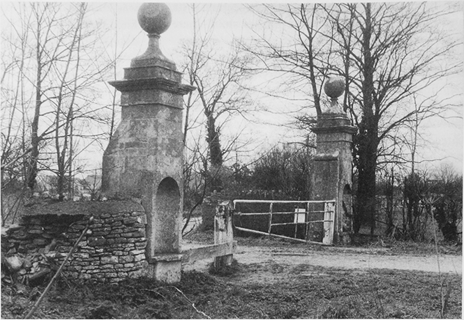
16. Manor Farm, gate piers at the entrance to the drive.
The Crown held Ashton Keynes manor until 1605; the land of Leigh was severed from it and sold in 1548. (fn. 136) A 98-year lease of the Ashton Keynes part of the manor granted in 1538 by Tewkesbury abbey to Sir Anthony Hungerford (fn. 137) was superseded by an 87-year lease granted in 1550 by the Crown to Sir Anthony (d. 1558); the new lease descended in the direct line with the manor of Down Ampney (Glos.) to Sir John Hungerford (d. 1582), Sir Anthony (d. 1589), and Sir John (d. 1635). (fn. 138) In 1605 the reversion was bought from the Crown by Sir Philip Herbert (earl of Montgomery from 1605), (fn. 139) who in 1612 sold it to Sir John Hungerford. (fn. 140) In 1623 Sir John sold the manor, and presumably surrendered the leases, to Sir Thomas Sackville, (fn. 141) who in 1632 sold the manor to George Evelyn (d. 1636). (fn. 142) The manor descended to George's son Sir John Evelyn (d. 1685), (fn. 143) who between the 1640s and the 1670s sold over half the manor, (fn. 144) including the part of the demesne later called Church farm. Most of the copyholds were sold individually. (fn. 145)
The reduced manor was devised by Sir John Evelyn to his daughter Elizabeth, widow of Robert Pierrepoint. Her heir was her son Evelyn Pierrepoint (marquess of Dorchester from 1706, duke of Kingston-upon-Hull from 1715), (fn. 146) who in 1714 sold the manor to Hawkins Chapman (d. 1768). (fn. 147) In 1770 the manor was settled on Henry Whorwood, a relative of Chapman's cousin Anne Chapman, who married Thomas Whorwood. By 1778 Henry Whorwood had increased the size of the manor by restoring or adding to it four estates. In 1772 he bought an estate sold by Sir John Evelyn to Henry Hawkins (d. 1658), of perhaps c. 100 a. from Evelyn's descendent Richard Hippisley Cox; (fn. 148) he also bought a larger estate, perhaps c. 150 a., from John Bristow, and two smaller ones, perhaps c. 30 a. and c. 15 a. respectively, from Samuel Teal and Somerset Wickes. (fn. 149) In 1779 Whorwood released the manor to trustees for sale, (fn. 150) and in 1781, after inclosure and the allotment of land to replace tithes, the estate covered c. 1,270 a.; (fn. 151) by 1785 it had been bought from the trustees by Henry's principal mortgagee John Paul. (fn. 152)
In 1781 the manor consisted mainly of four farms, Westham (later Ashton Field), Manor, Dairy, and North End. (fn. 153) Paul (d. 1787) devised it to his nephew Josiah Paul Tippetts (d. 1797), who took the surname Paul. Under John Paul's will the manor passed to Josiah's son John Paul Tippetts (later John Paul Paul) when the son reached the age of 24. (fn. 154) In 1796 North End farm, 311 a., was sold to Robert Nicholas, (fn. 155) and in 1808–9 John Paul Paul sold the lordship of the manor and Manor and Dairy farms, 509 a., to Nicholas. (fn. 156)
Manor House
The original demesne farmstead of
the manor was probably the moated ringwork known
as Halls Close. (fn. 157) A large house which stood on the north
bank of the Thames south-west of the church, may have
been built in the 18th century, perhaps soon after 1714,
the year in which a reduced Ashton Keynes manor was
bought by Hawkins Chapman, a member of a local
family. Until c. 1780 the house was lived in by the lord
of the manor (fn. 158) and was described as a mansion house. (fn. 159)
Gardens and 29 a. of parkland then lay north of the
house, (fn. 160) and a pair of earlier 18th-century gate piers
which stand beside the western branch of the
Cirencester road presumably mark where an east–west
drive from the house met the road. From the early 1780s
the house was not lived in by the owner, who in 1786
said it was too large to maintain from the income of the
estate and that part of it would be demolished. It fell
into disrepair and most of it was demolished between
1797 and 1802. In 1802 only a stable range and part of the
kitchen were said to remain. (fn. 161) In the 19th century the site
was redeveloped as a farmstead called Manor Farm: the
18th-century stone stable range, well-built with short
end wings and simple classical detail, was partly
converted; the northern wing, a carriage house, was
made into a barn, and buildings were added along the
west side; (fn. 162) new farm buildings were erected; and the
farmhouse was converted from the remains of the
mansion soon after 1831. (fn. 163)
The remains of the mansion house probably determined the size and plan of Manor farmhouse, which is an awkward L-shape with a large central chimney stack. The main block has two symmetrical piles of rooms of two storeys and attics, and a short south wing which has a hipped roof with a dormer. The east and west walls and part of the roof may be 18thcentury; the western side, which appears truncated, and the north wall were rebuilt with plain sash windows. In the 19th century a short brick east wing was added, and a long detached south-eastern range, (fn. 164) which had been demolished by 2005. In 2007 the stable range stood to the west of the dilapidated farmhouse.
Church Farm Estate
The estate later called Church farm was originally part of the rectory estate but by the 16th century had been merged in the main manorial estate and was probably the demesne farm. In 1655, when it was sold by Sir John Evelyn to Henry Hawkins (d. 1658) (fn. 165) it comprised c. 187 a. and the principal farm buildings. The estate seems to have descended to Henry's son John Hawkins (d. 1687) and have been settled on the marriage of John's daughter Joanna and Jasper Chapman. In 1738 the Chapmans' daughter Joanna and her husband Thomas Master (d. 1770) held the 187-a. farm, (fn. 166) and in 1787 their grandson Thomas Master sold it to Robert Nicholas. (fn. 167)
A second estate, perhaps 100 a. bought by Hawkins c. 1654, (fn. 168) probably also descended to his son John, and thereafter to John's daughter Elizabeth Cox and her descendants, (fn. 169) who sold it in 1772 to Henry Whorwood, lord of Ashton Keynes manor. (fn. 170)
Church farm descended as part of the Cove House estate, until 1913 when the farm, then 118 a., was bought by A. W. Bowley (fn. 171) (d. 1957). (fn. 172)
Church Farm buildings
By the 16th century the
demesne farm was focused upon Church Farm, on the
north-east corner of the moated site just south of the
parish church. The present house has two parts, both
possibly containing medieval fabric and arranged in an
L. A two-storeyed, south-eastern range of the mid-16th
century or slightly later is linked to a taller, mainly early
18th-century north-western range of four irregular bays
by a short return which combines fabric of both dates.
The south-eastern range has been much altered, but
details suggest that in the later 16th century, when the
manor belonged to the Hungerford family, it was part
of a fairly high-status dwelling. It was apparently a
chamber block in which heavy beams with vase stops
and unmoulded joists support an upper floor reached
by an inserted timber winder staircase. A four-light
timber mullioned window in the south wall, blocked by
the addition of an 18th-century extension connected
with farm use, lies adjacent to a small stone
chimneypiece ornamented with brackets and with a
lion rampant and the initials 'E R' in plasterwork on the
wall above. South-west of the house the farm buildings
include a barn which may be contemporary with the
north-western range of the house; they were converted to
dwellings in the late 20th century. Part of the manorial
demesne, including Church farm, was sold as a separate
estate in 1655 and perhaps then or later a farmstead, from
which the remaining demesne may have been worked,
was built north of the church. The farmstead was later
called successively Manor Farm and Old Manor Farm,
and a new farmhouse was built c. 1800. (fn. 173)
Westham (Ashton Field) Farm
Westham farm, 458 a. in 1890, (fn. 174) passed as a rump of Ashton Keynes manor from John Paul Paul (d. 1828) to his son Walter Matthews Paul (fn. 175) (d. 1861), who devised it to his wife Elizabeth. (fn. 176) The farm passed to their son A. G. Paul (d. 1912), who devised it to his wife Loetitia. (fn. 177) The farmstead, which was probably built in 1779, was called Ashton Field Farm by 1875. (fn. 178) The farmhouse, a standard type of four bays and two storeys, was doubled in size in the 19th century with the addition of a parallel range. In 1914 Loetitia Paul sold the farm to Hubert Cowley (d. 1916), in 1919 Cowley's executors sold it to William Haynes, and in 1920 Haynes sold it to Clements Cowley. By 1921 Clements Cowley had sold the farm in portions. The farmhouse and 201 a. were bought by Brig.-Gen. R. E. H. Dyer (d. 1927), 204 a. was bought by Giles Gobey (d. 1925), and 59 a. was bought by P. A. Read, the owner of Dairy farm. Ashton Field farm passed from Dyer to his widow Frances, who conveyed it to their son G. E. M. Dyer in 1930; in 1936 Dyer sold it to the Cotswold Bruderhof. In 1939 Gobey's land, called Ashton Downs farm, was sold by his surviving executor to the Bruderhof, which also owned Old Manor farm. (fn. 179)
COVE HOUSE ESTATE
A freehold estate in Ashton Keynes had emerged as a gentry residence c. 1700. It was probably held by Oliffe Richmond (d. 1691), and Bridget Richmond (d. 1701) who bought land there including Kent End farm. Bridget devised her estate to her son Oliffe Richmond, (fn. 180) probably the Oliffe Richmond who died in 1757. The younger Oliffe's heir was his son Oliffe (d. c. 1768, without issue), whose estate in Ashton Keynes covered c. 340 a. and was divided between his nephew Edward Nicholas and sisters Joanna (d. 1768 unmarried) and Jane (d. 1773 unmarried). Joanna's share was divided between Edward and Jane, (fn. 181) and in 1778 the whole estate was held by Edward's sons Robert and John, both minors. (fn. 182) Robert acquired John's share by exchange in 1785, (fn. 183) bought Church farm in 1787, North End farm in 1796, and the lordship of Ashton Keynes manor and Manor and Dairy farms in 1808–9. At his death in 1826 Robert Nicholas owned an estate of c. 1,400 a. based on Cove House, (fn. 184) later called the Cove House estate. (fn. 185)
Under an Act of 1827 the Cove House estate was vested in trustees, (fn. 186) and it was later sold pursuant to decrees in Chancery. About 900 a. was bought in 1846 by Harry Vane (from 1864 Harry Vane Powlett, duke of Cleveland), and 502 a. was bought by Vane in 1857. (fn. 187) The estate passed in 1891, on the duke's death, to his grandnephew Arthur Hay (from 1900 Arthur Hay-Drummond). In 1913 HayDrummond sold it to L. B. Woodford, who sold it in portions between then and 1917. (fn. 188)
Cove House
Situated on the north side of Fore
Street, it apparently originated as an L-plan twostoreyed house of the late 16th or early 17th century.
It became a gentry residence c. 1700 and was
extended to the south, after which four rooms on
each floor were arranged around a pair of central
chimney stacks. (fn. 189) Ashlar gate piers of the early 18th
century stand at the south entrance. Around the mid
1780s, Robert Nicholas (fn. 190) had the whole south range
encased to create a main block of five by five
irregular bays with an attic in the hipped roof; the
north range of the original house was adapted as a
service wing. Fore Street was diverted around an
allotment awarded to Robert Nicholas at inclosure
in 1778, which was laid out as a garden to the south
of the house by 1828. A walled kitchen garden and a
small park were laid out north of the house. (fn. 191)
Classical stables and a coach house were built east of
the house by 1831. (fn. 192) Around that time, the house was
given new sash windows and a top-lit staircase. In
1901–2 the house was again renovated and enlarged,
and additional stabling and accommodation for male
servants was built around a quadrangle east of it; (fn. 193) by
1920 a ballroom had been added at the south end of
the east front. (fn. 194) In the Second World War the house and
its park were requisitioned for use as a military camp,
and huts were erected in the park. For a few years after
the war the rural district council housed civilians in the
huts. (fn. 195) In 1950 the outbuildings were converted for
residence and Cove House became two dwellings. (fn. 196) To
the east of Cove House, an early 19th-century stone
farmhouse, with a large stone barn behind, belonged to
Cove House by the early 20th century, when it had been
enlarged and divided into cottages. (fn. 197)
RECTORY ESTATE
Ashton Keynes church was possibly among the endowments of Cranborne abbey (Dorset) transferred to Tewkesbury abbey (Glos.) in 1102; it was appropriated by either one of the abbeys and, like Ashton Keynes manor, was an endowment of Tewkesbury abbey until the Dissolution. (fn. 198) The rectory estate presumably at first consisted of all tithes from Ashton Keynes and Leigh and of a small manor. The rectory estate was presumably reduced when Tewkesbury abbey gave an estate of tithes to the vicar of Ashton Keynes. This had probably taken place by the later 13th century. In the 16th century the vicar paid a yearly pension of 4 marks to Tewkesbury abbey, in return for the revenues from this estate. (fn. 199)
An estate at Ashton Keynes, apparently a small manor, was held in the early 13th century by Thomas of Sandford (d. by 1242), who held the lordship of Chelworth (Cricklade). The estate at Ashton Keynes was held as dower by Thomas's widow Agnes, passed to his nephew and coheir Adam of Purton (d. c. 1265), who was said to hold it of Tewkesbury abbey, and passed to Adam's grandson and coheir Robert de Keynes (d. in or before 1281); Robert's heir was his son Robert, a minor. (fn. 200) In 1305–6 the small manor was disputed between Tewkesbury abbey, which claimed it as part of the Rectory estate, and Robert, who claimed it as a lay fee. The dispute was resolved in favour of the abbey. (fn. 201) By the 16th century the abbey had evidently merged the demesne of that manor with that of Ashton Keynes manor, of which it was lord.
In 1540, when Tewkesbury abbey was dissolved, the Rectory estate passed to the Crown, (fn. 202) and it descended with Ashton Keynes manor to Sir John Evelyn. (fn. 203) In the 1640s and 1650s Sir John apparently sold tithes with copyholds from which they arose, (fn. 204) and in 1672 he sold the remainder of the estate to John Hawkins (d. 1687). The reduced estate apparently consisted of a small holding, which may formerly have been a copyhold of the small manor, and of about half the great tithes of the parish. (fn. 205) It passed to Hawkins's daughter Mary (fl. 1719), the wife of Thomas Warner (d. 1736), and Thomas held it in 1705. After the death of Mary and Thomas it was held by trustees for the benefit of Francis Wyatt and Joanna Boughton, the younger children of their daughter Joanna Wyatt. (fn. 206) The trustees apparently sold the estate, which by 1777 had been bought from Benjamin Adamson of Bath by Henry Whorwood, the lord of Ashton Keynes manor. At inclosure in 1778 Whorwood received an allotment of 107 a. to replace his rectorial tithes from Ashton Keynes, an allotment of 8 a. to replace the commonable land of the small holding, and 14 a. at Ashton Keynes from the vicar in exchange for his rectorial tithes from Leigh. The 129 a. was added to Ashton Keynes manor. (fn. 207)
OTHER ESTATES
Bowley Estate
A. W. Bowley, the owner of Church
farm since 1913, (fn. 208) and of other land in Ashton Keynes,
bought Kent End farm, 166 a., and Rixon farm, 142 a. in
or soon after 1917, the same year that he purchased the
lordship of Leigh manor. (fn. 209) He sold both farms between
1924 and 1927, but by 1933 had acquired Wheatley's
farm, 36 a. (fn. 210) In the late 1930s Bowley sold Church farm
to one Lieberman, from whom he bought it back c. 1952.
The farms descended to his son A. W. Bowley (d. 1981)
and to his son Mr A. K. Bowley. In 2005 Mr Bowley
owned c. 200 a. in the parish, Church farm and
Wheatley's farm. (fn. 211)
Old Manor (formerly Manor) Farm
Formerly part of
Cove House estate, it was sold in 1914 to Mr Vizor. In
the 1920s it was acquired by M. J. Habgood, (fn. 212)
apparently the owner in 1934, (fn. 213) and in 1939 it was sold
by Francis Telling to the Cotswold Bruderhof, the
owner of Ashton Field farm. In 1941 the Bruderhof sold
the land of the farm to the London Police Court
Mission, (fn. 214) which in 1942 sold it to G. B. Young. Later in
the 1940s 14 a. of it was bought by A. W. Bowley, who
added that land to Church farm; then or c. 1950 the
remainder, from most of which gravel has since been
extracted, was bought by M. C. Cullimore or a
company controlled by him. In 2005 those lands
belonged to Mr. A. K. Bowley and Moreton C.
Cullimore (Gravels) Ltd. respectively. (fn. 215)
Manor (otherwise Coppice) Farm
Formerly part of
the Cove House estate, in 1913 it was sold to Sarah
Freeth, widow of Joseph Freeth. (fn. 216) By 1928, when it was
called Manor farm, it had passed to R. G. Freeth. (fn. 217) In
1969 Freeth sold it to Moreton C. Cullimore (Gravels)
Ltd., a company which afterwards owned it in 2005. (fn. 218)
Bruderhof Estate/Ashton Approved School
In 1941 the
Cotswold Bruderhof sold its estate of 494 a. acquired in
1939, consisting of Ashton Field farm, Ashton Downs
farm and Old Manor farm to the London Police Court
Mission, (fn. 219) a charity which used the buildings of Ashton
Field farm as an approved school and its land as a farm
on which the boys who lived at the school worked. The
management of the school was transferred to Wiltshire
County Council, which in 1973 bought the estate.
Before and after 1973 portions of the estate were sold,
mainly for gravel extraction, (fn. 220) and in 2005 the council
sold the buildings and the farm, 260 a., to the National
Children's Homes. (fn. 221)
Dairy Farm
Another portion of the Cove House
estate, 161 a., was sold in 1913 to P. A. Read, (fn. 222) who sold it
to Moreton C. Cullimore (Gravels) Ltd. in 1955, the
company which still owned the land in 2005. (fn. 223)
North End Farm
Acquired by Frederick Chamberlain
from L. B. Woodford, purchaser of the Cove House
estate, it covered 279 a. when purchased in 1917. (fn. 224) It
passed to Douglas Chamberlain (fn. 225) who, apparently in
the 1950s, sold most of it to E. H. Bradley & Sons Ltd.
for gravel extraction. (fn. 226)
Kent End Farm
A. B. Fletcher acquired the farm
between 1924 and 1927, presumably by purchase from
A. W. Bowley, (fn. 227) and owned it until, in the period
1965–71, he sold it in portions to Moreton C. Cullimore
(Gravels) Ltd.; the company owned it in 2005. (fn. 228)
Rixon Farm
Between 1920 and 1924, again
presumably by purchase from Bowley, Rixon farm
passed to Aubrey Seymour, (fn. 229) who owned it as a 237-a.
farm in 1929. (fn. 230) Seymour (d. 1967) (fn. 231) was succeeded by his
son Arthur, who sold most of the farm to E. H. Bradley
& Sons Ltd. and 18 a. to Moreton C. Cullimore
(Gravels) Ltd. (fn. 232)
E. H. Bradley & Sons
This gravel-working company,
operating in Swindon since c. 1900, (fn. 233) acquired North
End farm in the 1950s and most of Rixon farm, c. 1970.
Moreton C. Cullimore (Gravels)
The Stroud (Glos.)
haulage company, established c. 1927, (fn. 234) acquired for
gravel extraction Old Manor farm, c. 1950, Dairy farm
in 1955, Manor (Coppice) farm in 1969, and Kent End
farm 1965–71. It also acquired 18 a. of Rixon farm c. 1970.
The company still owned these properties in 2005.
ECONOMIC HISTORY
AGRICULTURE
In 1086 there were 15 ploughteams on the estate called Ashton, and enough cultivated land for one more. The lord's demesne land was worked by only two teams and five servi, and the tenants shared the other 13 teams. There were 20 households of villani, 12 of bordars, and four of coscets, or cottagers. There were 200 a. of meadow and ½ square league of pasture. (fn. 235) The estate almost certainly included the land which became Leigh parish and the farmsteads of some of the tenants stood on that land. (fn. 236)
Before Inclosure
Most of Ashton Keynes's agricultural land was used in common until 1778. Some of its common pastures lay open to common pastures of other villages and to the king's woodland in Braydon forest, and intercommoning took place. West of Ashton Keynes village a common pasture lay open to Somerford Keynes, and south-west of the village one called South moor lay open to Minety and probably to Leigh; (fn. 237) animals might pass and repass across the common pastures of Minety and Leigh between Ashton Keynes, Chelworth (in Cricklade), and the uninclosed land of Braydon forest south-west of Chelworth. (fn. 238) In 1256 the area of pasture shared by Ashton Keynes and Somerford Keynes was restricted or altered by an agreement between the lord of each manor, (fn. 239) and in 1387 the king's commissioners found that the men of Ashton Keynes might feed all their animals in Braydon forest except goats; pigs were excluded from the forest in the fence month and sheep were restricted to the lawns and excluded from the coverts. (fn. 240) North of Ashton Keynes village a 163-a. pasture called Tudmoor was shared by Shorncote, Siddington St Mary (Glos.), and Siddington St Peter (Glos.), and in the 17th and 18th centuries the men of Ashton Keynes also claimed the right to feed animals on part of it. (fn. 241)
In 1086 and throughout the Middle Ages a small proportion of Ashton Keynes's land apparently lay in demesne. (fn. 242) About 1210 the stock on the demesne of Ashton Keynes manor included 16 oxen, six cows, 150 sheep, and 27 pigs, (fn. 243) and in 1281 the demesne of the small manor which formed part of the Rectory estate included 102 a. of arable, 42 a. of meadow, and feeding for 16 oxen. (fn. 244) The two demesnes had apparently been merged by the 16th century and, c. 1550, besides the demesne nearly all of Ashton Keynes's land was shared by six free tenants of Ashton Keynes manor who held c. 150 a. and by c. 53 copyholders of the manor with tenements in Ashton Keynes. (fn. 245) A small proportion of the land was held by tenants of the manor with tenements in Leigh, (fn. 246) and 20 a. of meadow was part of Shorncote manor. (fn. 247) Both the demesne and the copyholds with tenements in Ashton Keynes consisted mainly of open-field arable, commonable meadow, and rights to feed animals in the common pastures. The demesne included a farmstead and c. 265 a., of which 152 a. was arable and 107 a. was meadow; 40 copyholders farmed c. 1,200 a. in holdings of between 83 a. and 6 a. and there were c. 13 cottagers. Typically the copyholds included twice or three times as much arable as meadow. (fn. 248)
Some of Ashton Keynes's commonable land was inclosed around the 1590s, this apparently included arable near the village, pasture called Rixon east of the village, meadow land near Waterhay bridge, probably in Leigh, and meadow on Ashton down north of the village. (fn. 249) On the eve of inclosure in 1778 Ashton Keynes had c. 2,130 a. of commonable land, 818 a. of open fields, 475 a. of commonable meadow, and 837 a. of common pasture. The arable lay in three fields, North, c. 317 a., East, c. 235 a., and West, c. 266 a., roughly north, northeast, and north-west of the village; the strips were small, the 168 a. belonging to Oliffe Richmond in the mid 18th century lying in 174 strips. The meadow, Ashton mead, lay east of the village beside the Thames and Shire ditch. The demesne plots in Ashton mead were evidently of 6–12 a. but most plots were smaller: Richmond held 21 plots totalling 39 a. in all. There were eight common pastures, all of which lay in the south-west part of the parish. The two largest were South moor, 341 a. south of Swill brook, and the Common, 285 a. apparently mainly west of the village. Home common, 117 a., Broadhurst, 36 a., Mare leaze, 24 a., and Startlets, 23 a., lay immediately south and south-east of the village; the other two common pastures were of no more than a few acres. (fn. 250)
In 1604 the demesne farm was of 332 a. and included Church farm, 75 a. in nine closes, 166 a. of open-field arable, and 91 a. of apparently commonable meadow; the closes included 32 a. inclosed about the 1590s, 20 a. of the down and 12 a. of Rixon. (fn. 251) In the mid 17th century it was apparently divided into holdings later called Church and Manor farms, and new buildings c. 200 m. north of the church may have been erected on Manor farm. In the early 18th century 187 a. was held with Church farm; it consisted of 40 a. in six closes, 100 a. of apparently open-field arable, and 47 a. of commonable meadow. (fn. 252) There remained many smaller farms with farmsteads in the village, probably still c. 40 in 1604. Of c. 55 copyholds there were 14 of between 30 a. and 60 a. assessed at 1 yardland, and nine of between 20 a. and 35 a. assessed at ½ yardland; the other copyholds were smaller. (fn. 253) In 1614 the vicar's glebe included farm buildings, 20 a. in closes, a nominal 75 a. in the open fields, and 6 a. of commonable meadow. (fn. 254) Outside the village Rixon Farm was built in the 17th or 18th century on land probably inclosed around the 1590s. The high proportion of meadow and lowland pasture in the parish favoured animal husbandry, and presumably the smaller farms could support flocks and herds larger than those on many farms of similar acreage elsewhere.
Inclosure
The animals of Ashton Keynes were excluded from Braydon forest without compensation when the Crown disafforested it in 1630. The men of Ashton Keynes were debarred from the right of common by the court of the Exchequer, which permitted the inclosure by decree, on the grounds that the land which they held had formerly been Crown land and that the right had not been part of Ashton Keynes manor when the Crown sold it in 1605. (fn. 255) Intercommoning by the men of Ashton Keynes was further restricted in 1767, when the common pasture of Leigh was inclosed, (fn. 256) and apparently ceased in 1780. The land of Ashton Keynes was inclosed under an Act of 1777 and in 1778 the commissioners allotted 147 a. of South moor to the men of Minety, who had shared that pasture until then, and set a boundary between Ashton Keynes and Somerford Keynes where common pastures had lain open to each other. (fn. 257) In 1780 the commissioners authorized the inclosure of 113 a. of Tudmoor, which they deemed to be the Siddingtons' proportion of it; the men of Ashton Keynes were excluded from that part, (fn. 258) and the remainder of the common was considered Shorncote's land. (fn. 259)
Common husbandry in Ashton Keynes ceased in 1778 when, under the Act of 1777, the open fields, common meadow, and common pastures were divided, allotted, and inclosed. Exchanges of land were made (fn. 260) and the larger farms became generally compact; (fn. 261) outside the village a second new farmstead, Westham (later Ashton Field) Farm, was built apparently soon after 1778. The vicar received land in place of tithes and, by exchange, a farmstead in Leigh, (fn. 262) and from the late 18th century most of the glebe was worked from Leigh as Glebe farm. (fn. 263) In the early 19th century there were eight principal farms: in 1831 Westham was of 417 a., Manor 240 a., Church 113 a., North End 265 a., Kent End 103 a., Rixon 391 a., Dairy 192 a., and Glebe c. 186 a. (fn. 264) Besides those of Westham, Rixon, and Glebe, each of which stood outside the village, all the farmsteads stood on the village's periphery. There apparently remained smaller farms based in the village. In 1778, 14 proprietors were awarded allotments of between 45 a. and 10 a., most of whom presumably owned small farms; (fn. 265) in 1831 Wheatley's farm was of 79 a., and there were farms of 62 a., 33 a., and less. (fn. 266)
Farms and Farming
Probably from the earlier 18th century to c. 1780 the lord of Ashton Keynes manor lived in the mansion house south-west of the church, and in 1781 the farmstead c. 200 m. north of the church apparently lacked a farmhouse. About 1800 a new house was built at that farmstead, which in 1831 was probably the principal one of Manor farm. (fn. 267) By 1856 Manor farm had been divided into two. Evidently soon after 1831 buildings on the site of the mansion house were converted for farming and a new farmhouse was built there, and in 1856 Coppice (later Manor) farm, 166 a., included that farmstead, and Manor (later Old Manor) farm, 130 a., included the farmstead north of the church. (fn. 268) By 1845 Rixon farm had been reduced to 236 a.; 106 a. of Ashton mead which had formerly been part of it was then a separate holding on which a cowhouse stood on the site of buildings later called Tinkers' stalls. (fn. 269)
The principal farms with over 100 a. in c. 1850 remained the same in the mid 20th century, (fn. 270) and throughout this period there was more grassland than arable. In 1845 the 457 a. of Rixon, Church, and Kent End farms included only c. 160 a. of arable, and all the 106 a. held with the cowhouse was then meadow; in 1856 the 331 a. of Manor and Dairy farms included only c. 100 a. of arable. Of the 818 a. of arable inclosed in 1778 most remained arable in the 19th century. North End farm included 187 a. of arable in 1845 and Coppice farm 113 a. in 1856; (fn. 271) Westham farm, a sheep-and-corn farm c. 1890, was of 458 a. including c. 300 a. of arable. (fn. 272) Westham farm was divided in three in 1921 and, as Ashton Field farm, was increased to c. 490 a. c. 1939. (fn. 273) Most of the other farms were mixed or dairy farms in the earlier 20th century, (fn. 274) and in the mid 1930s the arable, mainly north-west of the village, was much less extensive than the pasture. (fn. 275) Between 1936 and 1941 Ashton Field farm was used for mixed farming by the Cotswold Bruderhof. (fn. 276)
Besides the eight or nine principal farms, there remained small farms in the parish throughout the 19th century and in the earlier 20th. In 1895 there were 14 people described as farmers, (fn. 277) and in the 20th century small farmsteads developed outside the village. In 1910 Wheatley's farm was of 96 a. and included a farmyard south of Oaklake bridge and another between Kent End Farm and Tinkers' stalls, (fn. 278) and in 1910 and c. 1940 there were smaller farms and smallholdings with buildings at North End, Kent End, Rixon Gate, Happy Land, The Derry, and Derry Fields. Cattle, pigs, and poultry were kept on the smaller holdings. (fn. 279) Also in the later 19th and earlier 20th centuries there was c. 45 a. of orchards in the village. (fn. 280)
Large scale mechanized gravel extraction from farmland began c. 1944: the exhausted pits filled with water, which by 2005 covered much of the parish. From the 1940s to the 1960s Ashton Field farm was cultivated partly by the boys who lived at the approved school there. In the 1970s it was an arable and dairy farm of c. 300 a. and from the 1980s it was an arable and sheep farm of 260 a. (fn. 281) The only other farmland in 2005 was south of the village and immediately north of it. Church farm and Wheatley's farm were then worked together from the buildings south of Oaklake bridge and from Bridge Farm in Leigh (formerly Cricklade) parish; the composite farm was a 500-a. dairy farm of which c. 300 a. lay outside Ashton Keynes parish and on which as many as 250 cows were sometimes kept. (fn. 282)
WOODLAND
The place-name suggests that ash-wood was obtained or worked nearby in the late-Saxon period. (fn. 283) In 1086 there was woodland assessed at ½ square league on the estate called Ashton, (fn. 284) and in 1330 a wood belonged to the lord of Ashton Keynes manor. The manor included Leigh, and at both dates the woodland almost certainly stood at Leigh; unlike Leigh, Ashton Keynes never lay within the boundaries of Braydon forest, and in 1330 the wood was said to have been recently disafforested. (fn. 285)
Ashton Keynes parish was sparsely wooded, and in 1604 Ashton Keynes manor had too little wood for the tenants to have firebote, housebote, ploughbote, or cartbote. (fn. 286) In 1827 the owner of the Cove House estate held 38 a. of woodland in hand. (fn. 287) In 1875, besides orchards, there was c. 40 a. of woodland in the parish; Clayhill copse, 8 a., stood north of the village; Eight Acre copse and adjoining woodland, c. 20 a., stood along the Thames west of it; and two smaller copses stood north-west of it. Clayhill copse survived, unchanged in area, in 2005. New covert, 5 a. beside the east boundary of the parish, was apparently rough ground in 1875 and was woodland later. Between 1899 and 1920 Freeth's wood, 7 a. south of the Thames and beside the west boundary of the parish, was added to the woodland adjoining Eight Acre copse, (fn. 288) and in the later 20th century Eight Acre copse was grubbed up to make gravel extraction possible. New covert, Freeth's wood, and the two copses north-west of the village all stood almost surrounded by water-filled pits in 2005. (fn. 289)
TRADE AND INDUSTRY
Mills
A mill at Ashton Keynes in 1086 (fn. 290) probably
stood on the site of the water-powered grain mill
belonging to Ashton Keynes manor, (fn. 291) on the Thames
south east of the church. (fn. 292) From c. 1550 or earlier it
was held by members of the Ferris family, as lessees
and afterwards as freeholders. In 1719 Thomas Ferris
settled it on the marriage of his daughter Elizabeth and
Thomas Wilkins (d. by 1744) and it passed to their son
Thomas (d. 1789) and to his son Thomas Wilkins. In
1760 the second Thomas Wilkins built an additional,
wind-powered, mill on Home common apparently
c. 200 m. east of Ashton House. (fn. 293) This may have gone
out of business c. 1793: (fn. 294) the windmill was no longer
used c. 1800 (fn. 295) and had been demolished by 1828. (fn. 296) The
water mill was worked by William Habgood in the
early 1820s, (fn. 297) and a William Habgood was in business
as a miller and maltster there until c. 1880. In the 19th
century water power was evidently supplemented by
steam power. Milling ceased c. 1900. (fn. 298)
Cloth making
Weavers were recorded in the village
in 1379, 1584, (fn. 299) and c. 1700; silk weavers in 1699 and
1712; (fn. 300) and a yarn maker in 1728. (fn. 301) London House was a
mercer's shop between c. 1604 and 1750. (fn. 302)
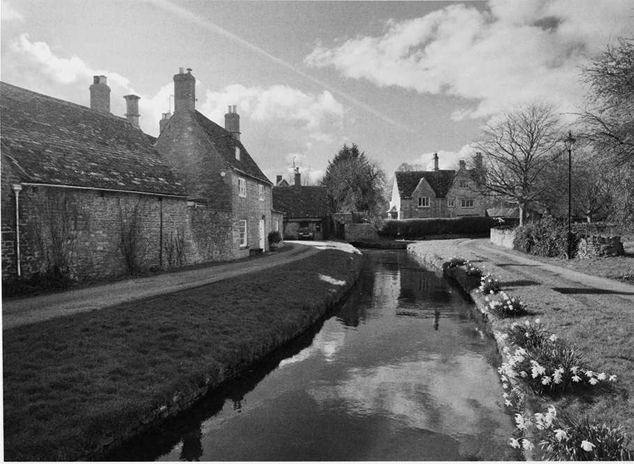
17. Church Walk looking west and leading to the site of the parish church, the moated site of Church Farm and a mill mentioned in Domesday Book. The 17th-century mill house closes the view.
Leather trades
These were more prominent. There
was a glover in 1379 and a tanner in 1577, (fn. 303) and both
trades persisted. There were two tanyards in the 18th
century. John Bennet was a tanner in 1701, a tanyard at
Ashton House descended in the Bennet family, and
around the 1760s Maurice Bennet (d. 1778) built a bark
mill near the house powered by water flowing over a
low weir built across the Thames. The complex
included drying sheds. In the later 18th and early 19th
centuries a second tanyard descended in the
Chapperlin family. Maurice Bennet (d. 1831) and
William Chapperlin were the tanners c. 1825. (fn. 304) Tanning
had apparently ceased by 1848. (fn. 305) Thomas Hobbs was a
glover at his death in 1704. (fn. 306) William Boulton, whose
relatives were later glovers at Westbury Leigh, was a
glover at Ashton Keynes in the 1850s, (fn. 307) and Ann and
Mary Boulton were glovers there in 1875. There were
glovers in Ashton Keynes until the early 20th century, (fn. 308)
and in the mid 19th century outworkers sewed for
glovers of Cricklade. There were 55 glove makers in the
village in 1851 and a similar number in 1861. By 1901,
when there were only 5 glove sewers in the village,
glove making had declined as a cottage industry there,
and it died out in the 1930s. (fn. 309) There was a currier in the
village in 1702 (fn. 310) and a currier's shop in the late 18th
century and early 19th. (fn. 311) There was a fellmonger in the
earlier 18th century; (fn. 312) William Boulton was both a
glover and fellmonger in the mid 19th century; (fn. 313) and
John Heaven was a fellmonger in 1861. (fn. 314) Shoemakers
worked in the village from the 16th to the 20th
centuries. (fn. 315)
Clay-Based Industries
Already made in the Middle
Ages, (fn. 316) pottery was produced by Barbar Vincent at Kent
End from c. 1650 or earlier. (fn. 317) William, Thomas, and
Henry Taylor alias Corver were potters in the early 18th
century, (fn. 318) and members of the Taylor family were
potters until c. 1825 or later. (fn. 319) In the late 18th and early
19th centuries there was a second pottery there. In the
early 19th century members of the Telling family were
potters, (fn. 320) and Edward Turner worked as a potter until c.
1860. (fn. 321) Clay pipes for tobacco smoking were made in the
late 17th and early 18th centuries. (fn. 322) A brickworks at
North End, where clay outcrops, was open in the 1840s. (fn. 323)
Bricks were made there until 1890 by members of the
Turner family. (fn. 324)
Carriages and Coaches
J. S. Ellison and W. J. Ellison
built carriages and coaches from the late 1870s until
the Second World War. (fn. 325) In the later 20th and early
21st centuries Ellisons was a private coach hire
company with a depot in the south angle of High
Road and Fore Street.
Agricultural Engineering
In 1918 Walter Powell
started an agricultural engineering business at North
End, and in the 1920s and 1930s he specialized in
electrical generators and water pumps. From 1939 W. J.
Powell Ltd. made parts for diesel engines, and c. 1947 its
premises were enlarged. The company's agricultural
business closed in 1950. Parts for both diesel engines
and petrol engines were made in buildings of wood and
corrugated iron until 1985, when the business was
closed; (fn. 326) in 2005 the buildings were largely disused. Also
in 2005 c. 10 businesses providing miscellaneous
services occupied premises in the small industrial estate
built in the 1970s on the site of the brickworks. (fn. 327)
Gravel Extraction
Most of the parish lies on gravel
and sharp sand deposited by the Thames and its
tributaries. (fn. 328) Gravel was dug for local use, from pits
near Dairy Farm in 1797, (fn. 329) and those beside the
Cricklade road in 1910. (fn. 330) Large scale commercial gravel
extraction apparently began in 1944 and was continuing
in 2005: in the 1940s and 1950s pits were opened on land
of North End, Dairy, Old Manor, and Ashton Field
farms mainly north-west and west of the village, and
c. 1965 a large building for the manufacture and storage
of building materials was erected beside the Cirencester
road; by 1966 some of the pits had been exhausted. (fn. 331)
Most gravel-working was undertaken by the firms of
Moreton C. Cullimore (Gravels) and Edwin H. Bradley.
From the late 1960s gravel was taken from the land of
Kent End farm and Cleveland farm, both east of the
village, from other land east of the village, and from
Manor farm west of it. (fn. 332) Buildings in which readymixed concrete was produced were erected on Dairy
farm in 1969, (fn. 333) a new road, Spine Road (East), was built
to link the gravel pits and the London-Gloucester road
in Latton parish, additional buildings were erected
beside the Cirencester road, and a factory in which
gravel was used in the manufacture of concrete blocks
and paving slabs was built beside the Cerney Wick road.
In 1986 c. 1 million tonnes of gravel and sharp sand was
extracted. By 1994 many pits north, east, and west of the
village had been exhausted; in one east of the
Cirencester road and in the extreme north of the parish
the gravel was replaced by refuse. Pits south of Rixon
Farm being worked in 1994 (fn. 334) had been largely exhausted
by 2001. (fn. 335) In 2005 gravel was being extracted from land
either side of Fridays Ham Lane, south-east of the
village near Waterhay bridge, south-west of the village,
and north of Ashton Field Farm.
Service Trades and Industries
Ashton Keynes was a
large village and the inhabitants engaged in a variety of
trades and services. There was a soap maker in the
village in the early 18th century, (fn. 336) and candles were
made from the mid 18th century to the 1850s. (fn. 337) There
were two tailors in 1379, (fn. 338) seven dressmakers in 1851,
and two laundries in the late 19th century and early
20th. (fn. 339) There was one malthouse in the 18th century, (fn. 340)
three malthouses in 1831, (fn. 341) and there was a small
brewery at the New Inn in 1845. (fn. 342) There were bakehouses
until the 20th century, (fn. 343) and, at a time when there were
many orchards in the village, cider mills in 1912; (fn. 344) in 1851
there were nine bakers and nine butchers. In the 19th and
20th centuries there were builders, stonemasons,
carpenters, plasterers, plumbers, smiths, saddlers, and
wheelwrights. Shops, including those of grocers and of
drapers, were kept in the 19th and 20th centuries. (fn. 345) In the
later 20th century their number fell, from five in 1964 to
two in 1991. (fn. 346) In 2005 there was one shop and a separate
post office adjacent. In 2007 the parish had a hairdresser,
several alternative health therapists, and professionals
offering assistance with small businesses and home
maintenance. (fn. 347)
SOCIAL HISTORY
Throughout its recorded history most residents of the parish lived in the roads and lanes of the nucleated village which grew up south and west of the church and manor house. Monastic ownership throughout the medieval period may have controlled the settlement's orderly development and limited agricultural change. Physical proximity and shared work strengthened social ties: some wealthy parishioners set up charities for the more numerous poor whose incomes were too high to qualify them for parish poor relief, but were nevertheless precarious; and members of the parish elite were responsible for the careful administration of the poor law and the workhouse. The vicar and churchwardens condemned innkeepers for encouraging drunk and disorderly behaviour in 1841, (fn. 348) and John Jefferies, a Baptist who came to live in Ashton Keynes in 1850, criticised the 'low state of morals in this dark village' in his journal. (fn. 349) Nevertheless, many residents gave small donations, which, added to larger sums given by the lord of the manor and the vicar, made possible the restoration of Holy Cross church in 1866–7. (fn. 350) From the late 19th century numerous clubs and societies flourished and a village hall was planned in 1914, but was not built because of the outbreak of the First World War. (fn. 351) In 1919 peace was celebrated with a tea, followed by dancing and singing, and after a trial of the Kaiser had found him guilty of horrible crimes his effigy was burnt on a bonfire. (fn. 352) The hall was eventually built in High Road in 1939, (fn. 353) near the junction with Fore Street, and remained open in 2005. During the Second World War, the village was fairly united in its hostility to the Cotswold Bruderhof, refugees who refused to assimilate into the community, and whose unwillingness to conform to accepted standards of behaviour and appearance on religious grounds was as threatening as their apparent economic success. In the later 20th century the village was largely inhabited by commuters working outside the parish. A lively sense of community helped to create a parish website in 1999, which continued to flourish in the early 21st century. (fn. 354)
INNS
There may have been three alehouses at Ashton Keynes in the 1580s. (fn. 355) In 1629 a judge at the Wiltshire assizes permitted a single alehouse to continue and suppressed two or more others. (fn. 356) The inn called the Holy Lamb in the early 18th century was called the Lamb in 1764, (fn. 357) and there was another inn or alehouse in the mid 18th century. (fn. 358) The Horse and Jockey was an alehouse in 1781, (fn. 359) which was one of four inns or alehouses in the mid 1820s; the others being the Cordwainers Arms, the Jolly Butcher, and the New Inn. (fn. 360) In 1841 the minister and churchwardens castigated the licensees for opening at prohibited times and thus failing to prevent drunkenness. (fn. 361)
Between the 1840s and the early 20th century there were several inns or beerhouses at any one time. The New Inn (from c. 1870 called the Cleveland Arms) stood at North End; on the High road the Cordwainers Arms (from c. 1850 called the White Hart) stood at the junction with Fore Street, and the King's Head stood at the junction with Back Street. The Star occupied Amcross Cottage on Park Place briefly c. 1871; the Horse and Jockey stood at the west end of Gosditch, and the Plough inn was opened c. 1875 in Back Street. The Cleveland Arms was closed c. 1914, and the King's Head, open in 1891, was demolished by c. 1910. The Plough remained open until the late 20th century, (fn. 362) the White Hart until the early 21st century, and the Horse and Jockey in 2008. (fn. 363)
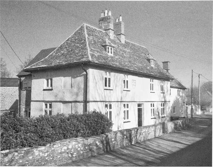
18. The former Plough inn, a late 17thcentury house in Back Street which became an inn c. 1875.
COMMUNITY ACTIVITIES
Clubs and societies, health care and recreation facilities developed in the 19th century. The Victoria Medical Institution and Benefit club was founded in 1836 to help members when they were sick and 1867–85 there were c. 75 members. (fn. 364) A coal club was formed in 1846, which delivered 59 tons of coal in 1847, (fn. 365) and remained active in the early 20th century. There was a clothing club in the late 19th and early 20th centuries. (fn. 366) In 1891 a penny bank was opened for adults and children who wished to save sums of up to £5. It was managed by Thomas Gleed who opened his home, Long House in High Road, for an hour each Friday afternoon to accept or return savings. Interest was paid on accounts of 10s. or more and the vicar personally gave extra interest to encourage saving. The money was deposited in the Post Office Savings Bank in the name of the penny bank, and those with savings of over £1 were encouraged to open an account there in their own names. In 1905 the penny bank had deposits of £152; its later history is obscure. At his house Gleed also managed a lending library of c. 200 books which was open for the same hour as the penny bank; members of the library paid 1d. a month. (fn. 367)
A workingmen's club and reading room was opened in rented rooms in High Road in 1884. Daily and weekly newspapers were taken and the rooms included one for drinking coffee and one for smoking; no woman was allowed in the club after 5 p.m. (fn. 368) The club apparently continued until the later 1930s. (fn. 369) There was a village band in the 1890s and early 20th century; Ashton Keynes, Somerford Keynes, and Leigh Horticultural Society was formed in 1895; and there were clubs for football and cricket in the early 20th century. (fn. 370)
An infant welfare clinic run by a voluntary association opened in 1923. In 1964 Ashton Keynes had a doctor's surgery, a baby clinic and a visiting library. (fn. 371) Between 1979 and 1989 a toddlers' play area was provided at the recreation ground, and two playgroups used the village hall. (fn. 372)
The recreation ground on the east side of High Street was given to the parish council in 1977, who leased it for 99 years to a charity called the Ashton Keynes Playing Field Committee; it remained in use in 2005. (fn. 373) A private sports field with a pavilion was opened at the east end of the village by E. H. Bradley & Sons Ltd. in 1975, called the Bradstone sports ground. In 1993 it was bought by the parish council and ownership was vested in the National Playing Fields Association, which leased the ground to the council. (fn. 374) In 2005 the field was used by Ashton Keynes's football and cricket clubs.
In 1991 there were clubs for cricket, football, bowls, tennis, badminton, darts, music and gardening, a branch of the British Legion, two old people's societies, two women's groups and a youth club. (fn. 375) There was also a village choir in 2005. (fn. 376)
The Cotswold Water Park
Because the water table is high, and because clay underlies the gravel deposits, in the upper Thames valley the pits from which gravel was removed have filled with water, and by the 1960s water-filled pits were a prominent feature of the landscape there. Gravel extraction catalysed a change from agricultural to recreational use, and many lakes were used by clubs for water sport or fishing. In 1967 Gloucestershire and Wiltshire County Councils designated the land from which gravel had been, or was expected to be, extracted as the Cotswold Water Park and set up a joint committee to promote the use of the park for sport, by naturalists, and as a general public amenity; nature conservation was later of increasing concern. The park lies in two sections, the Ashton Keynes section, straddling both counties and including all but the south-west corner of the parish, and the Fairford section, wholly in Gloucestershire; the committee consisted of representatives of the county councils and of Cirencester, and Cricklade and Wootton Bassett, Rural District Councils. The local authorities proposed to control activities in the park by means of the planning process. (fn. 377)
Keynes Country Park
Lakes which lay partly in
Ashton Keynes and partly in Somerford Keynes were
bought by Gloucestershire County Council and opened
as Keynes Country Park in 1970. (fn. 378) The later addition of
a 26-a. lake in Somerford Keynes increased the country
park to c. 135 a., of which c. 38 a lay in Ashton Keynes. A
new road opened in 1971 facilitated access to the
country park, where the lakes were used for bathing,
boating, and angling and there were facilities for other
leisure activities. In 1970 Wiltshire Wildlife Trust
bought a 7-a. field, north of Brook farm beside
Manorbrook lake, as a nature reserve, which it named
Upper Waterhay.
The Cotswold Bruderhof
The Cotswold Bruderhof was formed at Ashton Keynes in 1936. Its members were a Christian Mennonite group inspired by the German theologian Eberhard Arnold (1883–1935), (fn. 379) whose work derived from the teachings of Jacob Hutter (d. 1536); most were refugees from communities in Germany and the Netherlands, which had been suppressed by the political authorities. (fn. 380) They rejected private property amongst themselves and refused military service; (fn. 381) men were bearded and wore knee-length breeches, and women wore full-skirted peasant dresses with matching bonnets. (fn. 382) In 1936 they formed a company which purchased Ashton Field farm and other land. (fn. 383) By 1938 over 200 adults and children of different nationalities, including Britons, were following a self-sufficient communal lifestyle, living and working on the farm. (fn. 384) The community cared for destitute adults, Jewish refugees, and orphaned children. (fn. 385) Their main income came from dairying, for which they used the Hosier system; sheep, pigs, and over 1,000 poultry were kept; rye was grown, milled, and baked into bread; and orchards and bee-keeping were developed. The community diversified into trade; laundry and a printing works were established, and hand-crafted wood and ivory articles were made and sold. (fn. 386) In the face of hostility shown to their German origins and pacifist views following the outbreak of war, they left Ashton Keynes and emigrated to Paraguay in 1940.
New buildings were erected by the community and the large stone barn dated 1779 was converted into a chapel with a dining hall above. This retained many of the barn's original features and was given mullioned and transomed windows. Other stone farm buildings and a timber-framed cowshed were converted to living accommodation, a wood and asbestos hut was used as a dining room, two railway carriages became a printing works, and other buildings were used for woodwork. West of them, new ranges of living accommodation were built on three sides of a quadrangle and new utilitarian farm buildings were erected. The new ranges are of concrete blocks and in a spare style inspired by the domestic revival taste then popular in England and Germany. A printing works and single-storeyed workshops were also built of concrete blocks; other new buildings, including a kindergarten, school, bungalows, and laundry were simple, single-storeyed, and weatherboarded. (fn. 387)
The Cotswold Community
In 1941 Ashton Field farm was bought by the London Police Court Mission, a charity later called the Rainer Foundation, (fn. 388) and became an approved school for boys. In 1944 three existing buildings were converted into dormitories and a fourth dormitory was built. When the school opened in 1945 the farmhouse had become the headmaster's house, five bungalows and two pairs of cottages had been built for other staff, and more buildings had been converted or built to provide an assembly hall, library, schoolroom, dining hall, a kitchen, and other facilities. (fn. 389) The headmaster c. 1945–60 was C. A. Joyce. In the 1950s and early 1960s the school housed up to 100 boys, mainly from London. Boys were required to work on the farm, (fn. 390) and the emphasis was on correction. (fn. 391)
From 1967, when Richard Balbernie became principal, the emphasis changed to therapeutic treatment; (fn. 392) the school was re-named the Cotswold Community; and in 1969 its management was transferred from the Rainer Foundation to Wiltshire County Council. (fn. 393) In the late 1960s the community housed 60 or more boys, who were offered the options of education and training as well as farm work. (fn. 394) In the late 1970s the boys were aged between 12 and 16, and there were usually fewer than 40 in the 1980s. Most boys then were from outside London but very few were from Wiltshire, (fn. 395) and in 1997 the County Council transferred the management of the Cotswold Community to the National Childrens' Homes charity. (fn. 396) In 2004 the Cotswold Community, described as a residential community with education for boys, cared for up to 24 boys and had a staff of c. 55. The boys aged between 9 and 13 were categorized as emotionally disturbed as a result of early deprivation and stayed for an average of three years. (fn. 397)
EDUCATION
In 1674 a poor man was teaching small children to read. (fn. 398) There were six dame schools in 1819, when 87 children were taught; (fn. 399) four of the schools had evidently closed by 1833. A new school was opened in Fore Street in 1823 by the British and Foreign School society, and another school began in 1826. The first was run on the pupil-teacher system devised by Joseph Lancaster and in 1833 was attended by 50 boys and 25 girls. In 1833 the school opened in 1826 was attended by 7 boys and 20 girls, and two other schools had 13 pupils. (fn. 400) In the 1850s the school in Fore Street had 50–60 pupils and was probably a National school. In 1859 a school with c. 30 pupils was held in the Bethesda chapel, and a former farmer, reputedly a scholar, taught 15 boys in his house. (fn. 401)
A new National school and a master's house were built in elaborate gothic style in Gosditch in 1871. The school, a block of three classrooms, originally with a bellcot, could accommodate 150 children including 60 infants. In the early 1870s a night school was held there four evenings a week. Inhabitants of Leigh contributed to the cost of the building, and children from Leigh attended the school (fn. 402) until 1894, when a school was opened at Leigh. (fn. 403) Average attendance at Ashton Keynes school in 1906 and 1920–1 was 134; it declined to 94 in 1937–8, (fn. 404) when c. 110 children were on the school roll. In the Second World War the school was attended by evacuees, in September 1941 by as many as 56. In 1947, after the evacuees left, there were only 83 children on the roll. The number on the roll was reduced from 92 to 68 in 1957, when children over 11 were transferred to a secondary modern school at Highworth; (fn. 405) from 1963 children attended a secondary school at Purton. (fn. 406) The number of children attending the village school increased as the population rose in the late 20th century (fn. 407) and after 2004, when Leigh school was closed. In 2004 Ashton Keynes school had 140 children aged 4–11 on its roll. (fn. 408)
In 1871, what was described as an adventure school was attended by six boys and ten girls. (fn. 409) A grammar school for boys, held in 1895 in a house in Park Place, had by 1899 been moved to Swindon. (fn. 410) A school was opened at Ashton Field Farm c. 1936 for the children living at the Cotswold Bruderhof community. In 1938 it had 14 trained teachers, about half of whom were English, although most of the teaching was in German. The Bruderhof sold Ashton Field Farm in 1941 and went to South America. (fn. 411) From 1944 the farmstead was the site of an approved school, from the late 1960s called the Cotswold Community, which housed boys from outside the parish.
CHARITIES FOR THE POOR
Bridget Richmond (d. 1701) gave £10 by will to benefit the poor; the interest was to be spent on bread given to poor families at Easter. Oliffe Richmond (probably he who died in 1757) also gave £10 by will for a similar purpose. (fn. 412) Those gifts were probably the origin of a charity with £14 capital ascribed in 1786 to an unknown donor. (fn. 413)
Alice Hawkins (d. 1711) gave £100 by will to the second poor, those not receiving parish relief. Half the charity's income was to be given as doles, half as apprenticeships. The trustees bought 6 a. in Somerford Keynes with feeding rights there, and at inclosure in 1807 they received an allotment of 3 a. to replace the feeding rights. In 1829 the land was leased for £20, and in the early 1830s the rent was spent on doles and apprenticing. The trustees also distributed, as doles, the income of the charity ascribed to an unknown donor. About 1868 Hawkins's charity had an income of £26, that of the unknown donor one of 8s. 2d. (fn. 414)
Sybilla Chapman (d. 1756), Alice Hawkins's granddaughter, gave £600 by will to the second poor of Ashton Keynes. The income from the capital was reserved to Sybilla's brother Hawkins Chapman (d. 1768) for his life and, to replace the £600, in 1757 Chapman gave a rent charge of £30 payable to the trustees of the charity from his death. The charity was to spend £10 every other year on apprenticing and to divide the rest of its income equally among 40 of the second poor. In the early 1830s each of 40 people was given 12s. 6d. on 21 December each year. None might receive a dole from both Hawkins's and Chapman's charities in one and the same year. The £5 a year from Chapman's charity allocated for apprenticing was combined with the apprenticing money of Hawkins's, and in the early 1830s an apprenticeship was paid for in most years. (fn. 415)
In 1778, at the inclosure of Ashton Keynes's commonable land, 25 a. was allotted in trust for the second poor of Ashton Keynes as compensation for loss of benefits. The income from the 25 a. was distributed yearly on Christmas day to all the second poor, including beneficiaries of Hawkins's and Chapman's charities. In 1833, when the charity's income was c. £40, there were 59 beneficiaries, each of whom received between £1 14s. and 7s. About 1868 the income was £51 10s. (fn. 416)
In the early 20th century the vicar of Ashton Keynes and representatives of the parish council managed all four charities. Money was distributed about Christmas time each year, preference being given to those who had lived in the parish for more than a few years: in 1904 each of 40 people received 12s. 6d., each of 92 received 9s. 6d., and each of 14 received 5s. Between 1902 and 1905 three apprenticeships were paid for. (fn. 417) In 1926 the charities' income was £120 and in 1946, when it was £108, each of 102 people received 20s., each of four new claimants received 5s., and £15 was transferred to an apprenticing fund. From 1966 there were gifts of coal in addition to those of money. In 1968 the 25 a. allotted in 1778 and the 3 a. allotted in 1807 were sold to companies for gravel extraction. The proceeds of the sales were invested and the charities' income rose. In 1970, when the income was £1,551, the charities gave away £275 in cash and coal worth £45. (fn. 418)
In 1979 the four charities were united as the Ashton Keynes charity by a Scheme which provided for the trustees to include the vicar of Ashton Keynes and two nominees of the parish council. Under the Scheme the charity might, if it were needed, give £15 a year to help people under 25 years old to enter a trade or profession; the rest of its income was to be used generally to relieve need or provide benefit in Ashton Keynes. (fn. 419) In 1982 the rent charge was sold to the owner of the land from which it arose. In 1985, when the income was £4,535, the charity paid £100 towards an apprenticeship, contributed £3,000 towards the cost of land purchased for the village hall, gave £400 to hospitals, and made 56 gifts of £20 to parishioners at Christmas. (fn. 420) In 2003, when the charity retained the 6 a. at Somerford Keynes, its income was £6,800 and it spent £5,000. (fn. 421)
John Bowley (d. 1911) gave £300 by will, the interest on which was to be used to benefit old people in Ashton Keynes, six men and six women. (fn. 422) In the 1920s £12 was given away each year, and in 1948 the charity's income, nearly £12, was given away in 12 equal portions. (fn. 423) In the late 20th century and early 21st the income was allowed to accumulate. (fn. 424)
LOCAL GOVERNMENT
MANOR
The abbot of Tewkesbury withdrew his men of Ashton Keynes from the courts of Cricklade hundred. An attempt to compel him to return them, made in the early 1220s by the lord of the hundred, (fn. 425) apparently failed and, besides the manor court, the abbot held a view of frankpledge in respect of Ashton Keynes manor. (fn. 426) In the later 13th century he successfully claimed a tumbrel, gallows, and the right to enforce the assize of bread and of ale. (fn. 427) The men of Leigh were subject to Ashton Keynes manor courts until 1548, and in both places certain tenants were obliged to serve as tithingman. (fn. 428) In 1600 a gallows was said to have stood on the parish boundary south of the village. (fn. 429) From 1538 to the early 17th century the manor court and the view were held by members of the Hungerford family under a lease of the manor; from the later 17th century there was little land held of the manor by copyhold tenure and the manor court probably had little business. (fn. 430) No records of the manor court or the view of frankpledge between the late 18th century and the early 19th century have so far been found.
A combined court and view met in the autumn yearly from 1825, at the New Inn (later the Cleveland Arms) or the Cordwainers Arms (later the White Hart) except for the last meeting in 1912, which was at the Plough. The court appointed a constable, tithingman, and a hayward and from 1831 appointed two haywards. It heard presentments of public nuisances, most caused by the condition of roads, bridges, and, especially, watercourses; the court ordered that the nuisances should be amended, and made other orders to restrict the use of the lanes and waste ground for cattle and horses. (fn. 431)
PARISH
In the year to Easter 1776 the parish spent £235 on poor relief, and in the three years to Easter 1785 an average of £310. In 1802–3, when at 3s. 6d. the poor rate was about average for the hundred, £626 was spent on permanent relief for 60 adults and 45 children and on occasional relief for 37. (fn. 432)
Ashton Keynes had two overseers of the poor, each of whom, in the early 19th century, relieved the poor for six months. (fn. 433) By 1790 the parish had a workhouse, (fn. 434) which in 1797 had a kitchen, a brewhouse, a room equipped for yarn to be made, three other rooms, and a garret; (fn. 435) the building gave its name to the pocket of settlement in which it stood, 'Workhouse End'. (fn. 436) There is no evidence of a master or mistress and, in so small a workhouse, the inmates may all have been women. Overseers' accounts, which exist for the early 19th century, show then that the parish provided food and other necessities for inmates, and in addition wool to be carded and spun. Most relief, however, was outdoor. The parish gave weekly doles, met extraordinary expenses, and sometimes set men and women to work. It paid for clothing and shoes and met expenses relating to childbirth, medical care, and funerals. It owned a house called the Red House or the Lot House which was sometimes used as an isolation hospital, and in 1808 it paid a salary of 12 guineas to a doctor. (fn. 437) In 1832 the vestry expressed its willingness to help families to emigrate. (fn. 438) Although the parish owned the workhouse until the 1840s or later, (fn. 439) from c. 1805 raw materials may not have been provided for the occupants and the building may have become a poorhouse. (fn. 440)
In 1812–13, when expenditure was £960, 56 people were relieved permanently and 43 occasionally. (fn. 441) By 1815–16 expenditure had fallen to £446 and it was below £1,000 throughout the 1820s. In the four years ending at Easter 1833 expenditure was over £1,000 in each, reaching a peak of £1,123 in 1831–2. (fn. 442) The parish joined Cricklade and Wootton Bassett Poor Law Union at its formation in 1835 (fn. 443) and remained part of it as it became a rural sanitary authority and a rural district. (fn. 444) From 1974 until 2009 the parish was part of North Wiltshire district. (fn. 445)
PUBLIC SERVICES AND UTILITIES
A county police officer lived at Ashton Keynes from c. 1865, and there was a police station in the village from the early 1920s (fn. 446) to the 1950s. (fn. 447) Later the parish was patrolled from Cricklade. (fn. 448) There was a post office from the later 1870s. (fn. 449) A telephone exchange was installed in 1924, and a new one built at North End in 1955, (fn. 450) was superseded in the late 20th century by a new building by the Cirencester road further north. Electricity was supplied to the village from 1929. A deep well, a pumphouse, and a water tower were built 1929–31 between Church Farm and Dairy Farm, and pipes were laid to premises in the village. The waterworks were enlarged to supply water to other parishes 1937–9 and two new wells were sunk in the 1950s. Street lighting was provided in 1950. (fn. 451)
RELIGIOUS HISTORY
PARISH CHURCH
The present church at Ashton Keynes was standing in the later 12th century. There was probably an earlier church on this large ecclesiastical estate, built either by Cranborne abbey before 1102 or afterwards by Tewkesbury abbey. (fn. 452) The parish covered the manor of Ashton Keynes, which included Leigh. A church, built at Leigh by the 13th century was a dependent chapel of Ashton Keynes. (fn. 453) At Leigh baptisms and marriages took place, but there was no right of burial for the inhabitants. (fn. 454) Ashton Keynes church was endowed with a small manor in Ashton Keynes and the church was originally served by a rector, whose income presumably derived from this estate and the tithes of Ashton Keynes and Leigh. The church was appropriated, either by Cranborne abbey before 1102 or by Tewkesbury abbey after 1102. Tewkesbury abbey held the Rectory estate until the Dissolution, (fn. 455) and appointed a vicar to serve the church. (fn. 456)
From 1778 the great tithes of corn, wool, and lambs collected from Leigh were payable to the vicar of Ashton Keynes, who was sometimes referred to as the rector of Leigh. (fn. 457) After Leigh church was licensed for burials in 1865, (fn. 458) the vicar was sometimes described as the perpetual curate of Leigh, (fn. 459) and the vicarage of Ashton Keynes church, to which Leigh church remained annexed as a chapel, was sometimes referred to as a united benefice. (fn. 460) In 1987 the benefice of Ashton Keynes with Leigh was dissolved, and a new benefice of Ashton Keynes, Leigh, and Minety was created. (fn. 461) In 2007 Ashton Keynes became part of a new benefice of Ashton Keynes, Leigh, Cricklade St Sampson and Latton, led from Cricklade, leaving Ashton Keynes without resident clergy for the first time in 700 years.
Advowson
Early medieval rectors were presumably presented to the living by Cranborne abbey, or after 1102, by Tewkesbury abbey. After the church, and its income, was appropriated, vicars were presented by the appropriator. The advowson, or right of presentation to the vicarage, certainly belonged to Tewkesbury abbey from the early 14th century until it passed to the Crown in 1540, when the abbey was dissolved. (fn. 462)
In 1538 Tewkesbury abbey leased the advowson with Ashton Keynes manor and the rectory estate for 98 years to Sir Anthony Hungerford, (fn. 463) having earlier granted a turn to Sir John Porte. In 1543 Sir John's assignee Thomas Leigh presented Richard Porte, (fn. 464) and in 1570 and 1579 Sir Anthony's son (Sir) John Hungerford presented. (fn. 465) The advowson descended with the manor and was bought by Sir Anthony's great-grandson Sir John Hungerford in 1612. (fn. 466) In 1623 Sir John sold the advowson and the manor to Sir Thomas Sackville, (fn. 467) to whom he apparently surrendered the lease of the advowson. In the same year Jonas Hill of Hinton Waldrist (Berks.) presented John Hill, presumably by grant of a turn, and in 1625 a vicar was presented by Sackville. (fn. 468) The advowson descended with Ashton Keynes manor until 1672, when Sir John Evelyn sold it to John Hawkins (d. 1687). (fn. 469) In 1675, for a reason that is obscure, the king presented. (fn. 470) The advowson may have been settled on Hawkins's daughter Alice, the wife of Toby Chapman, and it passed to Alice's son Hawkins Chapman, who bought Ashton Keynes manor in 1714. Edward Foyle presented in 1719 by grant of a turn and Hawkins Chapman presented in 1724. (fn. 471)
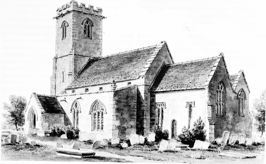
19. Parish church of Holy Cross from the south-east, c. 1810. Largely 14th-century externally, the church was built in the 12th century and probably replaced an earlier church on this large ecclesiastical estate.
The vicarage was moderately wealthy and from 1748 to 1885 the advowson was sold six times; in five cases the purchaser's apparent purpose was to re-sell it after making a single presentation. In 1748 Hawkins Chapman sold it to Revd Thomas Croome Wickes, who was instituted vicar on his own petition in 1783. (fn. 472) Wickes (d. 1786) devised the advowson to trustees for sale, in 1786 the trustees presented William Lea Briscoe as vicar, and in 1788 completed the sale of the advowson to him. (fn. 473) In 1802 Briscoe sold the advowson to Joseph Pitt, who in 1832 sold it to his son Charles and in 1834 presented Charles as vicar. (fn. 474) In 1866 John Swinford (d. 1869) bought the advowson from Charles Pitt and presented his son Smithett (d. 1884) as vicar. In 1884 John's son Thomas Swinford contracted to sell the advowson to John Milling and presented as vicar Milling's son Matthew (d. 1937). In 1885 Swinford completed the sale to John (fn. 475) (d. 1889), whose trustees sold the advowson in 1937 to a representative of the bishop of Bristol. In 1938 the advowson was transferred to the bishop, (fn. 476) who from 1987 has been the sole patron of the benefice. (fn. 477)
Value and Property
Before the appropriation of the church in the early Middle Ages, the rector would have derived a rich living from a small manor, which comprised the rectory estate, and from the tithes of Ashton Keynes and Leigh. (fn. 478) After the appropriation, the vicarage was endowed with both tithes and land. The vicar was entitled to a third of the great tithes, all tithes of hay, and all other small tithes of Ashton Keynes and Leigh. (fn. 479) Because Ashton Keynes and Leigh lay in the part of north Wiltshire where there was extensive grazing for cattle and dairy farming was important, (fn. 480) the vicar's tithes were valuable. The vicarage was valued at £5 in 1291, (fn. 481) £15 in 1535, (fn. 482) an average of £325 c. 1830, (fn. 483) and c. £555 in 1866. (fn. 484) A pension of 4 marks paid to the owner of the Rectory estate was said in 1535 and 1604 to be in recognition of the vicar's right to his tithes. (fn. 485)
In Ashton Keynes in 1611 the vicar held as glebe a mansion house, a barn, a stable or an oxhouse, a nominal 75 a. in the open fields, 6 a. of commonable meadow, feeding rights in common pastures, and 22 a. in closes; he claimed that the occupants of eight tenements, one with a 3-a. close, were his tenants. In the 17th century the vicar held no land in Leigh. (fn. 486) In 1778, at the inclosure of the commonable lands of Ashton Keynes, 191 a. was allotted to him to replace his tithes from Ashton Keynes, and 68 a. was allotted to him to replace his open-field arable, commonable meadow, and feeding rights. Also under the inclosure award Henry Whorwood, the owner of the Rectory estate, gave the remaining great tithes of Leigh to the vicar in exchange for 14 a. at Ashton Keynes; Whorwood also gave Weeks farm, a farmstead and 46 a. at Leigh, to the vicar in exchange for 79 a. at Ashton Keynes. (fn. 487) From 1778 all tithes from Leigh, where 188 a. was tithe-free, were payable to the vicar; they were valued at £287 10s. in 1839 and commuted in 1840. (fn. 488) After the exchanges of 1778 the vicar held 253 a. of glebe, of which 184 a. belonged to Weeks farm in 1801. (fn. 489) In 1783 no more than quit rents were being paid in respect of the tenements from which the vicar claimed rent in 1611. (fn. 490)
Weeks farm continued to be leased out, and the rest of the glebe was leased in portions. (fn. 491) All but the vicarage house, two other houses, and 9 a. was sold c. 1920. Weeks farm, which included the farmstead and 46 a. in Leigh, and 138 a. in Ashton Keynes, was bought by Harry Smith. (fn. 492) In the 20th century it was called Glebe farm and later Vicarage farm. (fn. 493)
In the mid-16th century a house, a garden, and a 2a. close were held by the church as the tenant at will of the lord of Ashton Keynes manor. (fn. 494) The income from the house and land may have been applied to church expenses. In 1783 the vicar complained that c. 1777 the lord of the manor had pulled the house down without compensating the church, and implied that no income was being received from the land. (fn. 495) Other land or feeding right in Ashton Keynes was replaced by a 4-a. field which was allotted to the parish at inclosure in 1778. (fn. 496) The income from the land was given to the church, and in 2005 the rent paid for it was £280. (fn. 497)
The registers date from 1582 and are apparently complete. (fn. 498)
The Vicarage House
The mansion house which
stood on the glebe in 1611 was built in 1584 by Thomas
Aubrey, vicar 1579–1623, and is probably the present
three-bayed two-storeyed house with attics and end
stacks. (fn. 499) The date stone on the north front inscribed
'TA' 1584 was later enclosed in a timber-framed porch.
In 1611 the house was 50 ft. long, of stone with a stoneslated roof, and of three storeys; on the ground floor it
had a hall, parlour, kitchen, buttery, and another room;
on the first floor two rooms and a study; and on the
second floor two rooms described as fair; it had four
chimneys and 12 glazed windows. (fn. 500) The house was so
heavily remodeled in the 18th century and later that no
earlier features remain, although the detached east
service and stable range has one re-used ovolomullioned window and the remains of another. In the
earlier 19th century sashes and casement windows were
inserted in the south front of the house, which was
rendered and given a bay window; a central staircase
was built, and a north-east kitchen wing added or
adapted from an earlier addition. It was sold in 1975,
and c. 1976 a new house in Richmond Court was built
for the vicar. (fn. 501)
RELIGIOUS LIFE
Middle Ages and Reformation
In the Middle Ages a
vicar served both Ashton Keynes and Leigh churches,
although in the 16th century a curate was employed to
serve Leigh. (fn. 502) Adam of Purton (d. c. 1265), who held the
Rectory estate, gave land in Chedglow (in Crudwell
parish) to endow a chantry, where a priest appointed by
the vicar of Ashton Keynes, could pray for Adam's soul
and the souls of his wives. The chantry was in a private
chapel on his manor, probably near the present church
at Ashton Keynes, but the arrangement had fallen into
abeyance by the early 16th century. At the Reformation
the land was confiscated by the Crown and, despite a
claim by the vicar that it was part of his glebe, it was
sold in 1549. (fn. 503) Lights burned before an image of the
Crucifixion in the church in the Middle Ages. (fn. 504) In 1553
commissioners left an 11-oz. chalice in the church and
2½ oz. of plate was taken for the king. The church had
four bells in 1553. By 1563, 5 a. of land given to fund
lights which had burned before the crucifix and which
was subsequently held by the Hayward, was also
confiscated by the Crown. (fn. 505)
Thomas Aubrey, vicar 1579–1623, employed a curate in 1584, the year Aubrey built a new vicarage house, where he may afterwards have resided. The curate was apparently reluctant to embrace Protestant practices, as he failed to wear the square cap required by Parker's Advertisements of 1566, and was said by the parishioners to be 'no preacher'; one parishioner, who failed to receive the sacrament in 1584, may have been a Dissenter. (fn. 506) Alan Bishop (d. 1664), vicar from 1625, was hostile to parliament, was accused of preaching too little, and had been sequestrated by 1658; he was replaced by Jacob Brent, who apparently served the church until his death in 1672. (fn. 507)
1660–1800
Isaac Gwinnett, vicar 1675–1719, and his
son John, vicar 1719–24, apparently both resided in the
parish. (fn. 508) About 1890 the church had a pewter flagon
dated 1665 and a silver chalice and paten cover each
hallmarked for 1732. (fn. 509) In 1683 the church lacked the
Book of Common Prayer. (fn. 510) Four new bells were cast by
Abraham Rudhall of Gloucester in 1707. Three of them
were still hanging in 1993, with another bell cast by
Rudhall in 1713. From 1724 to 1783 the vicar was Samuel
Barnes, who also apparently resided. From 1772, when
Barnes was aged 77, to 1788 the church was served by
curates. (fn. 511) The vicar 1783–6 was Thomas Croome
Wickes, (fn. 512) also vicar of Tetbury (Glos.). In 1783 the
churches at Ashton Keynes and Leigh were served by a
curate who, at Ashton Keynes, held two services each
Sunday between Lady Day and Michaelmas and one
each Sunday in the rest of the year. The curate preached
once every Sunday, held services on holidays and at
festivals, held communion services four times a year
with 20–30 communicants, and catechized in Lent. (fn. 513)
William Lea Briscoe, vicar 1786–1834, lived at Cricklade
in 1787, when he declared his intention to move to
Ashton Keynes. (fn. 514)
19th and 20th Centuries
Charles Pitt, vicar 1834–66,
lived at Malmesbury, where he was also vicar, and
Ashton Keynes was served by curates during his
incumbency. (fn. 515) About 1850 the curate held two services
each Sunday between Easter and Michaelmas, one each
Sunday in the rest of the year. A sermon was preached
at each service, and communion services were held six
times a year with c. 40 communicants; children were
still catechized. (fn. 516) On Census Sunday in 1851 there were
two services in the church, a morning one attended by
c. 200 and an evening one attended by 300–400.
From 1866 the vicars were all resident at Ashton Keynes, (fn. 517) and in 1876–7 the church was restored. (fn. 518) The vicar from 1884 to 1937 was M. J. T. Milling; his was the fourth recorded incumbency of over 40 years. (fn. 519) Milling served both Ashton Keynes and Leigh and usually employed an assistant curate. (fn. 520) For much of the 20th century services in Ashton Keynes church were held more frequently than they had been in the 18th and 19th centuries. (fn. 521) The vicar of Ashton Keynes continued to serve Leigh church. From 1982 he served Minety as priest-in-charge and from 1987 as vicar of the new benefice. In 1994 the bells, which still included three of those cast by Rudhall, and a treble bell cast by James Wells of Aldbourne in 1809, were rehung, and the ring increased to six by a new bell cast by John Taylor of Loughborough (Leics.). A sanctus bell dated 1649 also hung in the church in 1993. (fn. 522) The vicar continued to live in Ashton Keynes and in 2004, when Sunday services in Ashton Keynes church were normally attended by 33, a curate in training lived at Minety. (fn. 523)
CHURCH BUILDINGS
Holy Cross Church
20. The 12th-century font in Holy Cross church.
The church, known as the church of the Holy Cross by 1491, (fn. 524) is built of stone and consists of a chancel with north chapel, a nave with north and south aisles and north and south porches, and a west tower. (fn. 525) It was standing in the later 12th century, when a new chancel arch, enriched with chevron and diaper, and a north arcade were built. (fn. 526) The arcade, of four bays, was built in two sections at different dates; the pier and responds of the two eastern bays were later made octagonal. The later 12th-century font is also carved with chevrons. In the early 13th century the south aisle was built with a four-bayed arcade and traceried windows, and the east end of the church was altered. The south and east walls of the chancel were rebuilt, a traceried a traceried east window was inserted, and the chapel was built; the chapel, which has trefoiled triple lancets, a trefoiled piscina, and a credence shelf, is of high quality. In the 14th century the tower and the north porch were built, the clerestory was inserted, and the walls of the aisles and all the roofs were rebuilt: the exterior of the church retains its largely 14th-century appearance. A fragment of a reredos or tomb of the 14th century is set in the east wall of the north aisle, and a screen of that date may have stood across the west end of chancel and the chapel and have been lit from a high north window. In the later 15th century the south porch was built and the south doorway altered. (fn. 527) Also in the 15th century some windows were replaced, and fragments of 15th-century glass remain in the east window. The chapel was reroofed in the 17th century.
The church was restored in 1876–7 to designs by William Butterfield. The east end of the chancel was embellished: the altar was raised and given brass rails, above the altar ribs and bosses were added to form a vault, which was painted, and polychrome brickwork was added to the walls in a lattice pattern. To make that new work more conspicuous the chancel arch was widened. Most of the medieval fabric was otherwise treated conservatively, and very plain furnishings were installed. Bosses were fixed to the ceiling of the south porch, and the ceiling of the north porch was altered to match it. (fn. 528) Since 1877 alterations to the church have been minor; they included the fitting of an oak screen to the tower arch in 1947. (fn. 529)
Dissenting Chapels
There were Dissenters at Ashton Keynes in the later 17th and early 18th centuries: Anthony Whitfield, who would not attend church or allow his children to be baptized, had been excommunicated by 1670, as had two more parishioners by 1683, when two others refused to pay church rates. They may all have been either Baptists or Quakers, (fn. 530) and in 1732 a house at Ashton Keynes was licensed for Quaker meetings. (fn. 531) An Independent meeting house was registered for worship in 1776, (fn. 532) and one inhabitant in the 1780s was a Roman Catholic. (fn. 533)
Protestant Nonconformity was apparently stronger in the early 19th century. Houses were registered for Methodist worship in 1811 and 1813, and in 1838 for Primitive Methodist worship; in 1839–40 a simple gabled stone-fronted chapel with brick dressings was built in Gosditch. (fn. 534) In 1823 a house was registered for meetings of Independents, and in 1838 the Bethesda chapel, another simple gabled stone-fronted building with an adjacent manse, was erected in Fore Street for Congregationalists; (fn. 535) in 1839 the chapel was registered for the solemnization of marriages. (fn. 536)
On Census Sunday in 1851 there were afternoon and evening services at the Primitive Methodist chapel attended by 110 and 118, and morning and evening services at the Bethesda chapel attended by 35 and 42. (fn. 537) The Primitive Methodist chapel was renovated in 1863. (fn. 538) In 1869 John Jefferies, who had earlier attended meetings of Primitive Methodists and from 1850 to 1854 had preached at the Bethesda chapel, opened a house in High Road called the Grove for meetings of Strict Baptists. A Strict Baptist church was formed in 1874, where Jefferies was pastor until his death in 1891. The cause did not long survive Jefferies's death. (fn. 539) There was a resident pastor at the Bethesda chapel until the mid 20th century. (fn. 540) The chapel was closed in 1970, and the Primitive Methodist chapel closed in 1933, when it was sold to Robert Ellison and turned into a bakery. (fn. 541)