A History of the County of Wiltshire: Volume 18. Originally published by Boydell & Brewer for Victoria County History, Woodbridge, 2011.
This free content was digitised by double rekeying. All rights reserved.
'Historic Parishes - Minety', in A History of the County of Wiltshire: Volume 18, ed. Virginia Bainbridge (Woodbridge, 2011), British History Online https://www.british-history.ac.uk/vch/wilts/vol18/224-244 [accessed 30 April 2025].
'Historic Parishes - Minety', in A History of the County of Wiltshire: Volume 18. Edited by Virginia Bainbridge (Woodbridge, 2011), British History Online, accessed April 30, 2025, https://www.british-history.ac.uk/vch/wilts/vol18/224-244.
"Historic Parishes - Minety". A History of the County of Wiltshire: Volume 18. Ed. Virginia Bainbridge (Woodbridge, 2011), British History Online. Web. 30 April 2025. https://www.british-history.ac.uk/vch/wilts/vol18/224-244.
In this section
MINETY
MINETY parish lies c. 8.5 km. east-north-east of Malmesbury and c. 13 km. west-north-west of Swindon. (fn. 1) In shape it is roughly circular with an irregular southward extension into the former Braydon forest. Within a poorly drained parish of scattered farmsteads, the two main foci, Upper and Lower Minety, lie nearly 2 km apart; Upper Minety, the older settlement, is centred on the parish church, whereas Lower Minety grew informally in the 19th century along lanes leading to its railway station. John Aubrey's suggestion that the parish name derives from the abundance of wild mint (Mentha aquatica) which still grew there in the 17th century is probably correct, Minety therefore meaning 'mint island'. (fn. 2)
For most of its history the parish was a detached portion of the Gloucestershire hundred of Crowthorne and Minety, (fn. 3) although the parish church with the rectory and some other houses and c. 40 a. of land always lay in Wiltshire. This area is described on a map of 1777, and comprised the land east of Wiltshire Row between the vicarage to the north and the Green to the south. (fn. 4) The whole parish became part of Wiltshire under the terms of the Great Reform Act of 1832 and the Detached Parishes Act of 1844. (fn. 5) In 1884, 95 a. of land was transferred from Oaksey parish and in 1888 the total acreage of the parish was 1,528 ha. (3,778 a.). (fn. 6) In 1984 land to the south of Derry brook was transferred from Cricklade St Sampson parish to Minety, bringing the total area to 1,746 ha. (fn. 7)
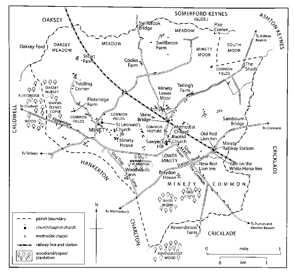
MAP 18. Minety Parish in 1875. Ancient settlement clustered around the church at Upper Minety; a new settlement grew around the railway station at Lower Minety. Until 1844, all but an island of land around the church was in Gloucestershire.
Boundaries
Minety is surrounded by the parishes of Ashton Keynes and Leigh to the north and east, Cricklade, Purton and Braydon parishes to the east and south-east, Hankerton to the west, and Oaksey to the north-west. (fn. 8) Boundaries to the north, east and south follow watercourses. To the north the parish boundary follows the course of Swill brook from the west to Pike Corner in the east, where it turns south and then east past Shades farm to join Derry brook. The boundary follows Derry brook from its most easterly point to the southern tip of the parish just north of Ravensroost wood. (fn. 9) Braydon forest lay south-east of this boundary until its disafforestation in the 17th century. (fn. 10) From the southern tip of the parish the boundary proceeds in a general north-western direction across Minety common, to the west of Kemble's and Woodwards farms, across Hankerton Road and into Flisteridge wood, where it meets Swill brook. (fn. 11) The parish boundary across areas of common between Minety and neighbouring parishes has been changed: 165 a. of South moor at Minety's north-eastern corner was transferred from Minety manor to Ashton Keynes manor in 1778, (fn. 12) and 95 a. of Oaksey common on Minety's north-western boundary was formally transferred from Oaksey parish to Minety in 1884. (fn. 13) In 1884 Minety farm, which comprised c. 275 a. and had belonged to Garsdon manor until c. 1800, was formally transferred to Minety parish. (fn. 14) Derry brook no longer marks the southern parish boundary, following the transfer of land beyond it from Cricklade St Sampson parish to Minety in 1984. (fn. 15)
Landscape
Minety is an area of flat land which drains into the river Thames c. 3.5 km. to the north. The north-east of the parish lies between 85 and 90 m. above sea level. In the south-west there are low rises of c. 120 m. at Kemble's farm and south-west of Braydon Hall. The soil is mainly Oxford Clay, known locally as Minety clay. (fn. 16) The terraces of the river Thames extend into the far north of the parish and alluvial soil lies along Swill brook and extends south towards Lower Moor in a triangle between Swill and Derry brooks. (fn. 17) Minety lay close to the heart of the early medieval Braydon forest, and Minety woods, which belonged to the abbot of Cirencester were recorded in the 12th century and parcels of its woodland and wood pasture remain as small copses and woods. (fn. 18) The heavy clay soil is unsuitable for arable crops and farming was mainly pastoral until the late 20th century. (fn. 19)
Communications
Roads
The Malmesbury to Cricklade road is the
main east-west artery running through the parish. (fn. 20) It
was turnpiked in 1755–6 and disturnpiked in 1876. (fn. 21)
Minety common turnpike stood at the junction of
Malmesbury Road and Silver Street. (fn. 22) It was demolished
in the 1990s to make way for housing. (fn. 23) Minety station
turnpike, now called Swiss Cottage, was located further
east on Malmesbury Road. (fn. 24) The Old Toll House at the
junction of Flisteridge and Wiltshire Row at Upper
Minety may have stood on a later turnpike road to
Crudwell. (fn. 25) In 1817 a turnpike road extending south
from Cirencester through Minety to the junction with
the Malmesbury to Cricklade road was proposed but
apparently not implemented. (fn. 26)
Upper Minety is linked to Hankerton, Crudwell and Oaksey by a number of minor roads extending west. Before inclosure in 1813 material for road repair came from Charlton Common. (fn. 27) The inclosure award set aside a plot of land near the border with Ashton Keynes parish at Shade's farm as a stone and gravel pit for repairing Minety's public roads. (fn. 28) In 1813 the parish had nine public roads and fourteen private roads. (fn. 29) Flisteridge road extends east connecting Upper Minety to Lower Minety. In Lower Minety a road branches off to the north to Sawyers Hill and follows a north-east route through Lower Moor to Ashton Keynes. Until the railway was built the road through Lower Minety continued east towards Cricklade, but it was terminated and the main road through Lower Minety turns southeast down Silver Street. After this road crosses the Cricklade to Malmesbury road to cross Minety common, it is known as The Common. The stretch of the Cricklade to Malmesbury road heading east from the crossroads with Silver Street and The Common is known as Station Road. Its route was altered when the railway was built, leaving London Lane as a dead end.
Railways
Minety station lies on the former
Cheltenham & Great Western Union Railway, which runs
north-west through the parish from Swindon to Kemble
and Cirencester (Glos.). Both the line and Minety station
were opened in 1841 and became part of the GWR in
1844. (fn. 30) At Lower Moor the railway passes over Rigsby's
Lane and there is a level crossing further north at
Brandiers. (fn. 31) The station was renamed Minety and Ashton
Keynes station in 1905. (fn. 32) When it was built the station had
cattle and milk loading facilities, which allowed local
farmers to transport their goods to urban consumers,
transforming the nature of the local economy. (fn. 33) Land was
acquired for dealing with slips at Minety in 1932, (fn. 34) and a
warehouse was erected in 1936. (fn. 35) The station closed to
goods in 1963 and to passengers in 1964. (fn. 36)
Population
In 1327 there were 29 taxpayers, (fn. 37) and 18 taxpayers were assessed in 1546. (fn. 38) In 1608 there were 46 adult males. (fn. 39) In 1650 there were c. 100 families, and in 1676 there were probably c. 220 adults. (fn. 40) In 1801 the population was 479 and it increased to 585 in 1841. (fn. 41) It peaked at 812 in 1861 but had fallen to 718 in 1881, a decrease attributed to emigration, and it declined to 652 by 1901. (fn. 42) The population averaged c. 700 in the early 20th century, but after the Second World War it rose steadily from 727 in 1951, to 1,398 in 2001. (fn. 43) In 1991 Lower Minety was said to be three times more populous than Upper Minety. (fn. 44)
SETTLEMENT
Before 1600
Evidence of early settlement has been found at Upper Minety and Lower Moor. Possible early Iron Age currency bars were found north-west of Upper Minety. (fn. 45) Near the boundary with Crudwell, between Oaksey Nursery and Braydon Brook, a Roman brick and tile kiln with associated buildings was discovered, possibly of the late 1st century A.D. (fn. 46) Fragments of Roman building material have been found near Mill Farm, Upper Minety, and potsherds there and at Osborne's Farm east of Minety church. (fn. 47) A pagan Anglo-Saxon bronze brooch was found north-west of Upper Minety, (fn. 48) and Anglo-Saxon artefacts, including part of a cross shaft, were found at the parish church. (fn. 49)
Settlement at Upper Minety apparently lay at the centre of a five-hide estate, which Æthelwulf king of the West Saxons granted to Malmesbury abbey, probably in the late 830s. (fn. 50) The Wiltshire enclave of land surrounding the church, which became the Rectory estate, preserves substantial traces of settlement earthworks and ridge and furrow cultivation. It is possible, therefore, that these are the vestiges of a late Anglo-Saxon village established by Malmesbury abbey, which subsequently atrophied once most of its lands reverted to royal ownership and after 1100 came into the possession of Cirencester abbey. (fn. 51) Medieval house platforms associated with pottery manufacture have been identified near Osborne's Farm south-east of the parish church. (fn. 52) At Lower Moor a pottery kiln and house platform date to the 13th century and there was at least one medieval farmstead. (fn. 53) There was also medieval settlement west of Lower Minety, near Moor farm and Gibb's Farm north of Lower Minety, and probably south of Swillbrook bridge, near the boundary with Somerford Keynes (Glos.). (fn. 54) All these farms and possible hamlets were presumably associated with Cirencester abbey's manor of Minety within Braydon forest. Woodwards farm was perhaps originally the residence of the abbot's woodward. (fn. 55)
After 1600
By the 17th century there were farmsteads on the sites of Hovington House, (fn. 56) The Mansells, Lyngrove Farm and the Old Inn at Upper Minety, and at Orchard House, Moor Farm and Lower Moor Farm at Lower Moor. (fn. 57) The Mansells was built on the site of medieval buildings. (fn. 58) It was probably named after a family of tenants: in 1706 John Mansell was tenant of a copyhold property belonging to Minety Manor. (fn. 59) The core of the present building dates to 1656 and was probably built for Edward Pleydell. Adjacent to it there is an early 18th-century timber barn. In c. 1900 William Oliver remodelled the house in Gothic style, by building a new wing with half-timbered fancy work and adding 15th- to 17th-century woodwork, brought in from elsewhere. (fn. 60) Telling's farmhouse and Askew Bridge House at Lower Moor date to the 18th century. (fn. 61) Buildings erected up to the 19th century, as elsewhere in north-west Wiltshire, were traditionally constructed of limestone rubble with thatched or stone slate roofs. By 1983 most roofs had been replaced with slates and only one thatched cottage remained at Emmett Hill, Upper Minety. (fn. 62) Upper Minety and Lower Moor remained the main areas of settlement in the 18th and early 19th centuries. (fn. 63)
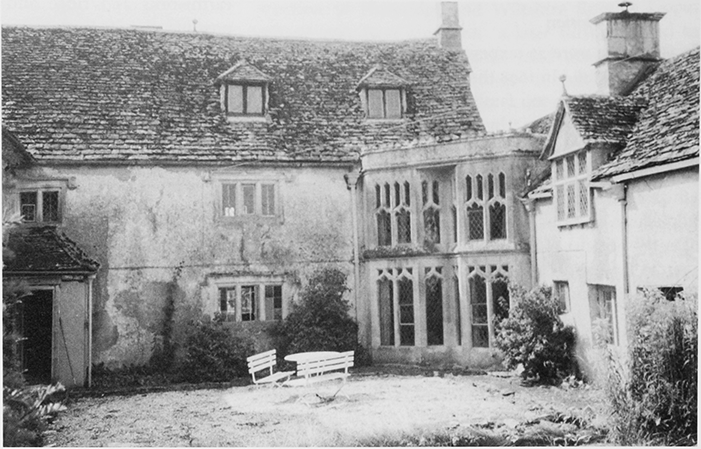
34. The Mansells, showing the elaborate medieval style work added c. 1900 to the 17th-century house.
Development in the 19th and 20th centuries transformed both the physical layout of the parish and its socio-economic structure. The two main areas of settlement are now Upper Minety, centred on the parish church, and Minety or Lower Minety, which lies just over 1 km. to the east. Lower Minety grew up after Minety railway station opened in 1841. New houses and cottages were built of brick soon afterwards along Station Road, (fn. 64) red-brick houses were built along the east side of Silver Street, and the west side of the street was developed in the 1890s. By 1898 Silver Street was described as a 'hamlet' comprising 'a number of small farmsteads and cottages', as well as flourishing businesses. (fn. 65) In the 20th century more housing was built at Lower Minety both along and behind Station Road and Silver Street and up Sawyer's hill. There was significant infill development on the north side of Flisteridge Road as it enters Lower Minety and at Clarke's Field on the east side of Silver Street near the junction with Malmesbury Road. Housing at Sawyers Close and Sawyers Rise off Sawyers Hill, Oakleaze and Silver Close off Silver Street, and Derry Park off Station Road has all been built since the 1950s as a mix of both private and council housing. Both Upper and Lower Minety were still expanding in 2007 and five new affordable homes were built at Sawyers Hill.
MANORS AND ESTATES
Minety lay in Gloucestershire because it was a detached portion of the royal manor of Cirencester (Glos.); it was the part of Braydon forest where hunting rights were reserved exclusively for this manor. From c. 1100 to 1539 it was held by the abbey of Cirencester. However, a parcel of land around St Leonard's church belonged to Malmesbury abbey and subsequently to the diocese of Salisbury. By the mid 12th century, the earls of Warwick possessed an estate assessed at half a hide in Minety which was later granted to Llanthony Secunda priory.
After the Dissolution, Cirencester abbey's estate was sold by the Crown and became known as Minety manor. In the 18th and 19th centuries new estates were built up, focussed upon Minety House and Braydon House.
MALMESBURY ABBEY ESTATE
Æthelwulf king of the West Saxons granted a 5-hide estate at Minety to Malmesbury abbey, probably in the late 830s. The grant was confirmed in 855. (fn. 66) By c. 1199 Malmesbury abbey also possessed the right of patronage to Minety church. (fn. 67) In 1270 the abbot and convent surrendered the estate to the bishops of Salisbury. The estate, which supported the office of the archdeacon of Wiltshire, was the property of Salisbury diocese until c. 1848, when it passed to the Ecclesiastical Commissioners. (fn. 68)
Rectory Estate
This belonged to Malmesbury abbey by c. 1199. (fn. 69) The estate, like the rest of the abbey's property, lay in the Wiltshire portion of the parish. (fn. 70) It too passed to Salisbury diocese and financed the office of archdeacon of Wiltshire. In 1609 it was leased to the Read family. (fn. 71) It was sold by order of Parliament in 1649. (fn. 72) After the Restoration it was returned to diocesan ownership. In the 1670s the estate comprised the 'parsonage' house, land which had been taken out of the churchyard, and c. 44 a. including a separate tenement called Reads and several small houses with gardens. (fn. 73) It also included small inclosures, given in lieu of common rights when part of Braydon forest was inclosed. In the 18th and early 19th centuries it was leased to the Calley family. (fn. 74) In 1838 the estate contained 60 a. (fn. 75) By 1848 ownership had been transferred to the Ecclesiastical Commissioners, (fn. 76) who leased it, and sold it by 1867 to William Perry Keene of Minety House. (fn. 77)
The rectory, or parsonage, house stood on a moated site close to Hovington House. The house was rebuilt in late 19th-century gothic style by Mr Moore, an estate agent, re-using stone and panelling and renamed St Leonard's Hall. In 1935 it was renamed Hovington House by the new owner Capt. G. Hovington Raimes. The house and its outbuildings have since been modified and extended. (fn. 78)
CIRENCESTER, LATER MINETY, MANOR
Before the Conquest, Minety, apart from the area around the parish church, was a detached part of the royal manor of Cirencester (Glos.). In 1066 ownership of Cirencester manor passed to the Norman kings, although Minety itself is not mentioned in Domesday Book. In the early 1100s, Henry I gave the manor to Cirencester abbey, but the Crown retained certain rights, including the right of pleas of the Crown and the use of Minety forest. (fn. 79) In the early 12th century Minety was part of the abbey's manor of Barton. (fn. 80) The abbey's rights over Minety were confirmed by Richard I and other subsequent monarchs. (fn. 81) The abbots of Cirencester acquired more land in Minety in the late 13th and early 14th centuries, (fn. 82) including 120 a. in 1314. (fn. 83) The right to tax tenants was a source of dispute between the Crown and the abbey in the 13th and early 14th centuries. (fn. 84) However, in 1343 Edward III confirmed the abbey's right to levy tallage on its tenants of ancient demesne, including those at Minety. (fn. 85) Cirencester abbey became involved in a number of lawsuits with local landowners in order to protect its property at Minety. (fn. 86)
After the dissolution of Cirencester abbey in 1539 the estate passed to Henry VIII, who granted it in 1544 to Edmund Bridges (Baron Chandos from 1557, d. 1573) and his wife Dorothy. (fn. 87) After Edmund's death, the estate passed to Dorothy for her life, (fn. 88) and then to Edmund's heirs, the barons of Chandos: to his sons Giles (d. 1594), and William (d. 1602), to William's son, Grey (d. 1621) and to Grey's son George, who held the estate until his death in 1655. In 1657 George Bridge's widow Jane, Lady Chandos, married George Pitt (d. 1694) of Stratfield Saye (Hants.) and in 1673 she settled the property on their descendents. (fn. 89)
The manor, or reputed manor of Minety descended to their son Edward (d. 1695), to his son George of Stratfield Saye (d. 1734), to his son George of Shroton (Dorset) (d. 1745) and to his son George Pitt, (fn. 90) (Baron Rivers of Stratfield Saye from 1776, Baron Rivers of Sudeley from 1802, d. 1803). Minety manor passed to his only son George Pitt (d. 1828), Baron Rivers, who died unmarried. (fn. 91) The property apparently passed to Joseph Pitt, who had rights in the property from c. 1792. (fn. 92) By the early 19th century the estate had become heavily mortgaged and in 1842 Joseph Pitt sold the manor, with c. 396 a. to Joseph Randolph Mullings. (fn. 93) It passed to Richard Mullings in 1859, when some land was sold to Revd John Edwards, vicar of Minety. (fn. 94) The manor descended with the Mullings family through Arthur Randolf Mullings, John Mullings, and Richard Mullings who died in 1956. (fn. 95)
LLANTHONY SECUNDA PRIORY ESTATE
Llanthony Secunda priory (Glos.) was granted a halfhide of land in Minety, free of all service, by Earl Waleran of Warwick (1184–1203), an estate which had earlier been granted by his brother, William, earl of Warwick (1153–84), to Hugh of Linguire for an annual rate of 12d. (fn. 96) This estate was sold into private hands in 1539. (fn. 97) It included a small property, known as Pynnrews in 1543. (fn. 98)
OTHER ESTATES
Minety House Estate
In the late 19th century Minety House estate was the largest in the parish. The Maskelyne family, resident in Minety by 1649, built up an estate which comprised copyhold and free land. (fn. 99) In 1770 Minety House belonged to Joseph Maskelyne (d. 1770), who left it to his brother Henry Maskelyne. (fn. 100) It subsequently belonged to the Keene family, whose memorials in the parish churchyard date from 1785, and their descendants the Perry-Keenes. (fn. 101) The Keene family owned property in the parish by 1805, (fn. 102) and in 1840 William Perry-Keene's estate comprised c. 220 a. in Minety and Hankerton parishes. (fn. 103) He was said to be the principal landowner in Minety. (fn. 104) When Col Perry-Keene sold the estate in 1879, it covered c. 530 a. in Minety and Hankerton and included pleasure grounds, wooded park land, and several farms. (fn. 105) In 1954 the estate covered c. 500 a. and there were three farms in Minety. (fn. 106) In the late 20th century lands were sold off and the estate contracted to 240 a. in 1971 and 36 a. in 1990. (fn. 107) In the late 20th century the house was renamed Minety Park. (fn. 108)
Minety House
In the late 18th and early 19th
century the site of Minety House was occupied by two
large buildings at right angles to each other. (fn. 109) These
have been incorporated in the central block of the
present house, which was built soon after 1840 for
William Perry-Keene, who lived there until his death
in c. 1885. (fn. 110) It is built of squared and coarsed limestone
rubble with blocked ashlar dressings and stone quoins,
hipped stone slate roofs and tall ashlar chimney stacks.
It has an L-shaped plan: at the centre stands the threestorey, three-bayed 19th-century block, with a central
advanced stone porch with a pediment. In the early
20th century two-storey, one-bay flanking wings were
added to the south front and a projecting wing at the
rear. (fn. 111) Henry Whatley-Estridge, who resided at Minety
House in 1895, may have been a relation of the Revd
Estridge who received a mortgage of Minety manor in
1821. (fn. 112) The house was occupied by Mrs Kirby in 1931,
and Douglas H. West in 1939. (fn. 113) Soon after the Second
World War the Minety House estate was purchased by
Major and Mrs M. H. Crocker, who still owned it in
1975. (fn. 114) The house changed hands several times in the
late 20th century. (fn. 115)
Braydon House (later Hall) Estate
At the heart of the Braydon House estate was an ancient freehold, which belonged to Joseph Keene senior in c. 1799. (fn. 116) In 1813 much of what is now the Braydon Hall estate was freehold property owned by his son, Joseph Keene junior including Waits wood and Old copse. (fn. 117) After his death in 1827 the estate passed to his son Thomas, (fn. 118) whose wife, Mary Pacey Keene lived there in 1848. (fn. 119) In 1854 the estate comprised c. 242 a. of almost exclusively pasture land, including land which became part of Distillery farm. (fn. 120) Henry Hibberd acquired the estate in 1856 for £5,000 and sold it between c. 1859 and 1867 to Mrs Fitzgerald, who remained in possession until c. 1890. (fn. 121) In the late 19th and early 20th centuries the estate had a succession of owners and tenants. In 1900 it was owned by Henry Workman. By 1903 it was the home of Herbert Horatio Nelson, viscount Trafalgar, who died there in 1905. (fn. 122) The estate belonged to Frederick Ziegler by 1920, (fn. 123) and in 1925 it covered c. 197 a. including 69 a. of woodland and wild sporting ground, and c. 10 a. of pasture. (fn. 124) In 1939 the owner was Major Geoffrey Henry Barrington Chance. (fn. 125) The estate comprised 197 a. in 1977, and by 1982 it had been enlarged to c. 317 a. (fn. 126)
Braydon House
Later known as Braydon Hall, it was
apparently erected on the site of an earlier building; a
plaque in the Hall states it was built in 1751 by George
Pitt, lord of Minety manor. In 1773 'Pound House'
stood on the site, a dwelling associated with the pound
for stray animals, located to the north. (fn. 127) It seems likely
that Joseph Keene senior incorporated parts of Pound
House in Braydon House, which would explain the
thick wall at the west end and the ragged joint to older
stonework on the north elevation. (fn. 128) It was called
Braydon House in 1799 when Keene's widow Sarah
lived there, although it was referred to as Pound House
in 1810. (fn. 129) In 1813 Braydon House was at the centre of
farming operations on the estate and had five main
blocks of outbuildings. (fn. 130) In 1854 it had 10 bedrooms
'and all the usual offices', and was described as being 'in
the centre of the finest fox-hunting country in
Europe'. (fn. 131) The house had a succession of tenants in the
late 19th and early 20th century and the stables were
rebuilt some time after 1900. (fn. 132) In c. 1920 Frederick
Ziegler employed architects Ernest and William
Newton to make considerable alterations to the house. (fn. 133)
By 1925 the residence comprised an entrance, lounge
hall, three reception rooms, fifteen bed and dressing
rooms, two bathrooms, and offices, surrounded by a
pleasure ground and a park. There was also stabling for
thirteen horses, two cottages, and a farm. (fn. 134) When
Braydon Hall was offered for sale in the 1980s the
property was said to have been recently 'totally
refurbished and no cost spared', and it then consisted of
four reception rooms, five bedroom suites, and a
nursery wing with five further bedrooms. (fn. 135)
St Bartholomew's, Gloucester Estate
St Bartholomew's hospital, Gloucester, had a small estate in Minety from c. 1245, which was still in its possession in 1731. (fn. 136)
ECONOMIC HISTORY
For most of its recorded history Minety was a rural parish and its inhabitants earned their living from the land. Pastoral farming predominated until the mid 20th century. In the late 20th century mechanisation and intensive farming techniques allowed more arable crops to be grown. Some former farmland is now used for housing and for wildlife conservation. Distillery meadows is a Wiltshire Wildlife Trust nature reserve on poor soil which was once part of Braydon forest. (fn. 137) Swillbrook lakes, lakes 46 and 48 of the Cotswold Water Park, are also nature reserves. (fn. 138) Minety had an important Roman and medieval pottery industry. After the coming of the railway in 1841, various shops and small businesses were established, few of which survived in the late 20th century. Late 20th- and early 21st-century development transformed the parish into a commuter village supplying workers for a far wider geographical area.
AGRICULTURE
Pre-Inclosure
Arable
In 844 Malmesbury abbey's estate at
Minety was assessed at 5 hides. (fn. 139) In 1312 Cirencester
abbey's tenants cultivated 6½ yardlands of arable land. (fn. 140)
In 1314–15 property which Cirencester abbey had
recently bought was said to include one yardland, and
38 a. of arable land leased out in small parcels. (fn. 141) In 1342
assarting, or clearing the waste or woodland of Braydon
forest for agriculture, was taking place in and around
Minety. (fn. 142) In the early 16th century the abbey's demesne
land was let out to lay tenants. (fn. 143) Pre-inclosure common
fields lay to the east of the churchyard, also around
Flisteridge farm, (fn. 144) and to the west of Shades farm. (fn. 145)
Pasture
In 1312, 48 households owned a total of
60 cows, 674 sheep, 44 horses and 38 pigs, which grazed
at Minety. (fn. 146) In 1314–15 Cirencester abbey had recently
bought property which included 21 a. pasture. (fn. 147) In 1488
the abbey kept a herd of cows on its pastures, (fn. 148) which
included one called the Sterte. (fn. 149) Minety moor, an area of
pasture between Minety and Ashton Keynes, was
grazed by animals from both parishes in the autumn
and winter months. (fn. 150) Common pasture at South moor,
south-west of Ashton Keynes village, was shared with
Minety's parishioners, (fn. 151) and the 1777 inclosure award of
Ashton Keynes allotted them 147 a. of South moor. (fn. 152) In
the 16th and 17th centuries large numbers of cows,
sheep and pigs fed on Minety's common pastures.
Many were bought by local farmers at fairs or from
drovers to be overwintered and fattened in Minety
before being sold on again to dealers. (fn. 153)
Meadow
Small areas of meadow land were located
by watercourses, mostly along Swill brook, the parish's
northern boundary. (fn. 154) Some meadow belonged to the
main estates and other parcels belonged to free tenants,
who gave them to Cirencester abbey in the 12th and 13th
centuries. (fn. 155) In c. 1221–1230 Cirencester abbey had meadow
at Wellmead, Brugham and Salemead. (fn. 156) Before c. 1300
Clement, vicar of Ashton gave part of Hawksbrook
meadow to the abbey, (fn. 157) and c. 1300 Robert de Keynes gave
the abbey his portion of Hawksbrook, which lay between
the woods of 'Huly' and 'La Sterte'. (fn. 158) In Hawksbrook
there was a water-meadow called Westham. (fn. 159) In 1301 there
was a dispute between the abbey and its tenants over 12 a.
of meadow. (fn. 160) In 1314–15 property which Cirencester abbey
had recently bought was said to include 11½ a. of
meadow. (fn. 161) Before Glastonbury abbey's dissolution, the
customary tenants made hay for their landlords on
meadows called The Acres, Broadmead, Pyeham, and
Courtleose. (fn. 162) Oaksey meadow belonged to Minety
manor and the manor's tenants had feeding rights in
1639, when it comprised of 30 a. of meadow and pasture.
Oaksey meadow lay along Oaksey brook between Oaksey
and Minety parishes, (fn. 163) and was later known as Lammas
mead. (fn. 164) There was a meadow called Stewards mead in
1758. (fn. 165) Swillbrook lakes were meadows on Swill brook,
which were dug out for gravel in the 1960s are now lakes
no. 46 and no. 48 of the Cotswold Water Park. (fn. 166)
Inclosure
Inclosure of common resources by landowners took place piecemeal in the 17th and 18th centuries. (fn. 167) George Bridges, lord of the manor, claimed in 1637 that his attempts to improve 1,200 a. of waste land were hindered by his tenants' rights. (fn. 168) Despite violent protests, (fn. 169) by 1651 he had inclosed c. 600 a. of the purlieu of Braydon forest. (fn. 170) Disputes over common rights in the former forest continued into the 18th century. (fn. 171) In 1811 an Act of Parliament provided for the inclosure of 728 a. of remaining common land, around one fifth of the parish. South moor, Lower moor, Sawyers hill, The Common, Flisteridge lane and Tidling corner were inclosed in 1813 and the main beneficiaries were Joseph Pitt, lord of the manor, who was awarded 174 a., William Maskelyne 82 a., William Keene 64 a., and Joseph Keene 58 a. (fn. 172)
After Inclosure
Farms and Farming
Several farms were based
on pre-inclosure freehold or copyhold properties. (fn. 173)
Pleydell's, Cooles, (fn. 174) and Osborne's farms probably took
their names from former inhabitants; in 1634 Nicholas
Pleydell owned farmland which was once part of
Braydon forest. (fn. 175) New farmsteads were built on parcels
of land inclosed in 1813, including Common Farm,
South Farm and New House Farm, built on Minety
common. (fn. 176) L. J. Manners of Moor farm wrote an
account of late 19th and early 20th-century farming in
Minety, before it was changed radically by
mechanisation and the use of chemicals. (fn. 177)
Minety House Estate
The estate owned five farms
in Minety in 1879: Home, Church, Flisteridge,
Woodwards and Osborne's. Minety House and
grounds together with a portion of Home farm
contained c. 189 a. and the remaining property was let to
tenants. (fn. 178) In 1941 the farms were leased out. (fn. 179) In 1954 the
estate covered c. 500 a. It included Minety farm, Home
farm, and The Elms. There were prestigious new farm
buildings designed by Stillman and Eastwick-Field. (fn. 180) By
1971 lands had again been sold off and the estate had
contracted to 240 a. although there were still nine fulltime farm workers in 1975. (fn. 181) By 1990 all the land had
been sold except 36 a. (fn. 182)
Stert Farm
The farm occupied a slight
promontory or 'tail' of land (from which the name
derives) in the north-west of the parish by 1777, but its
origins were probably much earlier. (fn. 183) In c. 1258–79
Richard of the Stert occupied a farmstead and a halfyardland holding. (fn. 184) When Cirencester abbey acquired
'La Sterte' in the late 13th century, it was an area of
pasture and woodland. (fn. 185) In 1544 it was a leasehold
property, (fn. 186) which belonged to Minety manor and at
that date it was pasture land. (fn. 187) The Stert was owned by
the George family in the early 17th century and
subsequent owners included the Blackwell family in the
late 17th and 18th centuries. In 1772 Richard Hippesley
Cox sold Stert and Swillbrook farms to Robert
Maskleyne. (fn. 188) In 1844 it was owned by Maurice
Maskleyne and leased to Henry Hiscock, when the farm
buildings were 'a good deal out of repair'; the farm was
divided by the railway line, but the fields were
connected by an archway under the railway. (fn. 189) In 1874
Henry Hiscock was tenant of c. 150 a. of pasture and
arable land. (fn. 190) In 1941 Stert farm was a dairy farm of 179
a. with some poultry, owned by the executors of A. P.
Read and leased to members of the Read family. (fn. 191)
Swillbrook Farm
The farm stood on its present site
by 1828, near the former site of Swill Brook House,
where Swillbrook bungalow now stands. (fn. 192) Swillbrook
and Stert farms and c. 85 a. were sold by Richard
Hippesley Cox to Robert Maskleyne in 1772. (fn. 193) In 1786
Robert Maskelyne (d. 1793) bequeathed the estate to his
nephew William Maskelyne. (fn. 194) In 1846 Maurice
Maskelyne owned Swillbrook farm and rented it to
Thomas Coole junior and Henry Hiscock. (fn. 195) In 1885
Swillbrook farm was a dairy and pasture farm of c. 87 a. (fn. 196)
In 1941 Swillbrook farm belonged to Cirencester
Conservative Benefit Society. It was the largest farm in
the parish with c. 221 a. Although the soil was 95 per
cent clay, c. 25 a. was farmed as arable and there were 79
cattle, pigs and poultry, and farm horses. (fn. 197)
Telling's Farm
The farm, which lies in the northeast of the parish on the north side of the road to
Ashton Keynes, near Moor farm, probably took its
name from yeoman Robert Telling and his descendents
who lived in Minety in the 17th and 18th centuries. (fn. 198) In
1914 Telling's farm was a productive dairy farm
comprising over 113 a. occupied by Mrs Mary Ann
Greenslade, a yearly tenant. (fn. 199) In 1941 James Ellison
owned the farm and kept a small number of cattle,
poultry and pigs on c. 109 a. (fn. 200)
Shades Farm
Lying on the north-east parish
boundary, it may be of ancient origin, as scead is an Old
English term for boundary. (fn. 201) In 1941 Shades farm was 110
a. leased by Mrs Prior of Silver Street to Mr T. Read,
who kept 49 cattle and 405 poultry. (fn. 202)
Grange Farm
Before the First World War, Albert
Prior of Shades farm bought a house in Hankerton
parish and re-erected it on the opposite side of the road
to Shades farm, where it became known as Grange
Farm. (fn. 203) The two-storey house was of prefabricated
construction, dating to c. 1860–80, of T-shaped timber
frame clad in corrugated iron with inner matchboard
lining. The space between the two skins was infilled
with sawdust. (fn. 204) The house was demolished in 2007 while
a new farmhouse was being constructed.
Farming after 1800
In 1838 there was 150 a. of
arable. (fn. 205) In 1870 c. 319 a. was used to grow corn crops and
c. 430 a. to grow green crops, particularly turnips and
swedes. (fn. 206) Corn and green crop farming declined
dramatically thereafter. In 1894 there were only c. 20 a.
of arable crops. (fn. 207) By 1900 only c. 22 a. was given over to
corn farming and c. 9 a. to green crops. (fn. 208) There were
village allotments on what are now Minety Church of
England primary school playing fields. (fn. 209) In the later 19th
century, after the coming of the railway, nearly all the
land was converted to pasture to feed 'hundreds of
cows and hundreds of pigs'. (fn. 210) Traditional cheese
production was replaced by the production of liquid
milk for the urban consumer market, (fn. 211) distributed from
the industrial yard at Minety station. (fn. 212) Dairy farming
dominated the local economy and in 1870 there were
561 mature cattle and 325 under two years old. (fn. 213) In 1910
there were c. 3,592 a. of permanent grass feeding 1,190
cattle and 338 pigs. (fn. 214) Sheep farming also continued;
there were 442 sheep and 196 lambs in 1870, 40 sheep in
1880, (fn. 215) and 219 sheep in 1910. (fn. 216)
In 1870 there were 73 farms and smallholdings in Minety; eight were more than 100 a. and 21 were less than 5 a. In 1891, 64 out of 74 farmers rented their land; in 1900, 821 a. was owner-occupied and 2,432 a. was rented, and in 1910 638 a. was owner-occupied and 2,988 a. rented. (fn. 217) In 1941 cattle and poultry farming predominated, with some pig farming. (fn. 218) In 1983 16 farms had dairy herds, while a small number kept beef cattle or poultry. Poultry houses were built on the east side of Silver Street in the 20th century. Poultry houses were also erected in the west of the parish just south of Hankerton Road in the 1970s. This site was purchased by Poultry First in 1992 and its buildings were modernised in 2005. (fn. 219) By 2006 most of the farmhouses had been detached from their land and sold as private homes. Dairy and beef farming continued and some arable crops were grown. (fn. 220)
WOODLAND
The whole of Minety parish lay within the bounds of Braydon forest, as defined in 1225 and 1279, and forest law had been enforced there as early as 1184–5. (fn. 221) By the mid 13th century the parish accounted for c. 3,778 a. of the total 31,393 a. of the forest. (fn. 222) Richard I allowed Cirencester abbey sufficient green and dry wood for the community's needs, and pannage for their pigs and other animals in the wood or forest of Minety: these rights were confirmed by subsequent monarchs. (fn. 223) In the late 13th century Katherine Paynell and her nephew, Robert de Keynes, gave the abbey Stert wood and he also gave a wood called 'Huly'. (fn. 224) Although by the time of the Braydon forest perambulation in 1300, Minety woods, among many others, were disafforested, they clearly continued thereafter still to be regarded as in some sense part of the forest. (fn. 225) In 1314–15 Cirencester abbey had recently bought 20 a. of woodland, which was leased to Robert de Keynes. (fn. 226) By 1573 part of Minety was outside the bounds of Braydon forest and a map of c. 1632 refers to land north of Derry brook as Minety common. (fn. 227) This area may have been part of the Charlton and Minety purlieu, one of four purlieus surrounding Braydon forest, where deer could roam and where animals belonging to the commoners were allowed to graze. (fn. 228) George Bridges, lord Chandos, had inclosed c. 600 a. of the purlieu by 1651. (fn. 229)
In the 19th century Minety had only small areas of woodland: in 1838 there were 75 a., (fn. 230) and in 1873 c. 93 a. of woods, coppices and plantations. (fn. 231) In 1871 Flisteridge plantation covered over 11 a. and was well stocked with oak and young larch. (fn. 232) In 2007 there were two main areas of wood in the parish, Flisteridge wood, Oaksey nursery and Maskelyne's copse in the west, and Waits wood and Old copse in the south, part of the Braydon Hall estate. (fn. 233) What was called Browning Oak in 1591, (fn. 234) is now Brownockhill plantation south-west of Lower Minety. In the early twentieth century herb gatherers from Minety collected medicinal herbs from the woods. (fn. 235)
TRADE AND INDUSTRY
Mills
A water mill once stood at the west end of
Chapel lane, where there was a relatively steep drop
from Sawyers hill. The hollows of the mill leat may still
be seen there. (fn. 236) The adjacent land was called Mill Pond
Ground in 1813, (fn. 237) and c. 1 km. north-west lay Great
Windmill ground, which may correspond with the
residence known as Windmill House in 1788. (fn. 238)
Pottery
Minety's Oxford Clay provided suitable
potting material: John Aubrey described the fullers
earth at the Gogges on Minety common 'as black as
black marbled polish'. (fn. 239) As early as 75 A.D. Minety may
have taken over brick and tile manufacture from the
Roman kilns at Brinkworth. (fn. 240) In the Middle Ages
Minety was a well-known centre of pottery production
known as 'Minety ware'. (fn. 241) The Minety pottery industry
may have developed 'a near monopoly' in the
Malmesbury area in the 14th and 15th centuries,
gradually supplanting wares from Cirencester and
Wootton Bassett. (fn. 242) Osbornes farm was at the centre of a
hamlet dedicated to pottery production. (fn. 243) Pottery was
probably still produced in the early 16th century. (fn. 244) The
market for Minety ware included the towns of
Cirencester, Tetbury, Malmesbury, Wootton Bassett
and Cricklade, all within a seven mile radius. (fn. 245) 'Minety
ware' has also been found further away at Bulkington, (fn. 246)
Burderop Park, (fn. 247) Broad Town, (fn. 248) and Old Town,
Swindon. (fn. 249)
Distilling
After Henry Hibberd purchased Braydon
Hall estate in 1856, he and William Keene established
the Wiltshire and Gloucester Agricultural Distillery
company, a limited company in 1857. Their aim was to
refine sugar from root crops such as beet, and turn it
into alcohol. They built a house and a distillery on 75 a.
of land. The enterprise failed and the company was
dissolved by 1859. (fn. 250) Distillery cottage and its land were
sold off by 1873, (fn. 251) and by 1898 it was known as Distillery
Farm. (fn. 252) The enterprise gave its name to Distillery
meadows, the Wiltshire Wildlife Trust nature reserve. (fn. 253)
SOCIAL HISTORY
In 1313 there were 48 households of taxpayers, (fn. 254) and in 1327 there were 29 households wealthy enough to be taxed. (fn. 255) The abbots of Cirencester and subsequent lords of the manor were non-resident and did not apparently exert strong influence over the community; although members of the Hungerford family may have rebuilt and redecorated Minety church in the 15th century, and the church contains Hungerford tombs. (fn. 256) Braydon forest seems to have provided cover for robberies in the 13th century, when several men from Minety were accused of robbing the abbot of Malmesbury's reeve and other crimes. (fn. 257) In the 16th century, a small number of minor gentry families lived in the parish. In 1522, 29 men were assessed for military service: the richest were the abbot of Cirencester, whose lands were valued at £8 18s. and Sir John Bridges, with lands worth £4 17s.; goods belonging to John Ridler were assessed at £30, William Hawkins at £26, Robert Riche at £20, and John Little at £16. (fn. 258) Around that date, between 12 and 20 yeoman families farmed most of the land, including Leonard Hawkins, whose estate was valued at £125 4s. 4d. in 1537, (fn. 259) and there was a small number of cottagers. A military muster roll of 1608 lists 46 men, five aged around 20 and the rest aged around 40; 24 were labourers, six butchers, four yeomen, and two carpenters. Some were wealthy enough to own military equipment including corslets and musket furs. (fn. 260) In the 18th and 19th centuries the main social division was between owners and occupiers of the land, and agricultural labourers. (fn. 261)
Ninety-five men from Minety served in the First World War. (fn. 262) During the Second World War a dummy aerodrome was built on the moor, north of Ashton Keynes road, just south of Swill brook. Search lights were erected in Minety park and there was a Royal Observer Corps listening post in the field next to Silver Street school. A Nissen hut from Cricklade was dismantled and re-erected near Minety station to serve as a British Legion HQ. (fn. 263) Many roads in Minety including sections of the Malmesbury to Cricklade road were closed off to store army reserve vehicles. (fn. 264) Prisoners of war were held at Minety and many worked on local farms. (fn. 265)
Between the two World Wars, local authority housing was built for rural workers at Upper Minety. In the later 20th century, many homes for middle class families were built in both Upper and Lower Minety. Farm houses were converted into exclusive homes for professional families and most residents commuted to work outside the parish. In the late 20th and early 21st centuries the parish had a strong community spirit: in 1991 a local government questionnaire raised the issue of the division between the two hamlets of Upper and Lower Minety, the parish council's response was 'We object to our village being designated as Upper and Lower – WE ARE MINETY'. (fn. 266)
INNS
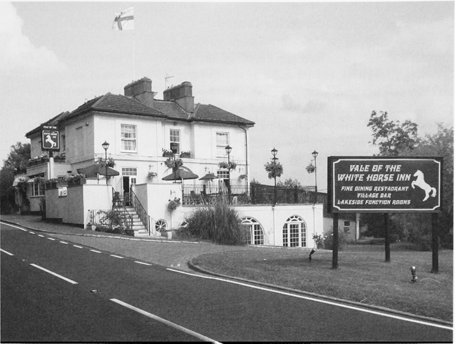
The Old Inn at Upper Minety stands c. 100 m. south of St Leonard's church. (fn. 267) The former church house was an inn commonly called the Carpenters' Arms by 1789, when John Cole leased it from George Pitt, lord of the manor. (fn. 268) Parish administration was conducted at the Old Inn: in 1838 landowners met there to discuss the commutation of tithes and it was used for public auctions. (fn. 269) The present building has 17th-century origins and is now a private house. (fn. 270) In 1848 it was known as the Axe and Compass and there were two other inns on the Malmesbury to Cricklade road: the Red Lion, later renamed the Posting House at the crossroads between Silver Street and The Common; and the Old Red Lion at Minety railway station. (fn. 271) The Old Red Lion belonged to Stroud Brewery Co. in 1898. (fn. 272) It was a private residence by 1983. (fn. 273) The Red Lion, or the New Red Lion, was owned by Luce and Co. of Malmesbury in 1898. (fn. 274) It was renamed the Turnpike in the late 20th century. (fn. 275) The Railway Hotel, later called the White Horse and now the Vale of the White Horse, was a purpose-built station inn and stood on the Malmesbury to Cricklade road near Minety station by 1853. A large three-storey building, it had a travellers' floor at the top, a 'navvies', or workmen's floor below, and goods storage on the lower levels. (fn. 276) In 1898 it was owned by Cripps brewery of Cirencester. (fn. 277) In the 1970s it became a hotel. (fn. 278)
35. The New Red Lion, now the Turnpike inn, one of three public houses built along the Malmesbury to Cricklade road in Minety.
COMMUNITY ACTIVITIES
By c. 1900 a number of shops and businesses had their premises along Silver Street, including a drapers, an oil and ammunition retailer, an insurance broker, and a stationer. (fn. 279) A post office was opened in the grocers in 1900. (fn. 280) In 1939 there were two garages, a wheelwright, two shops, a butcher, baker, carpenter, builder, blacksmith, cobbler, printer, timber merchant and haulier. The Wiltshire Gazette had an office at Minety, a physician and surgeon visited the village on Wednesdays and Saturdays and a coal merchant was located at the railway station. (fn. 281) In 1961 a mobile shop visited twice a week and most inhabitants worked in Swindon, whilst a few worked in Crudwell or Malmesbury. In 1964 there were three shops, two selling food, a post office and a garage. (fn. 282) Deliveries by a fishmonger and a butcher ceased in 1970 and 1981 respectively. (fn. 283) In 1989 Upper Minety had a combined shop and post office and Lower Minety had a shop, a separate post office, a DIY store and a petrol station. In 1991 there were still post offices at Upper and Lower Minety and Lower Minety had a food shop, a general store and a petrol station. (fn. 284) Lower Minety's shop and post office closed in the late 1990s and the petrol station closed in the early 21st century. Upper Minety's post office closed in 2008, but operated with restricted hours from Minety playing field pavilion in 2010. (fn. 285)
E. E. Taylor established the printers, Taylor's and Son, on Silver Street in 1884, which published Taylor's Directory of local businesses until the 1940s. In 1975 it was the largest employer in the parish with a staff of 19. (fn. 286) Telser Transport, a hauliers company was the second largest employer in 1975 with 10 employees. (fn. 287) Carpenters and sawyers had their premises at Lower Moor, below Sawyers Hill. (fn. 288) In the early 1980s there were several small factories and workshops, producing steel fabrics, double glazing and kitchen units. (fn. 289) In the late 20th century Home farm, which in 1941 was a relatively small pasture farm, was transformed into Home Farm Business Centre to house a range of small business, offices and workshops. (fn. 290)
In the 19th century hunting with the Vale of the White Horse hunt and the Duke of Beaufort's foxhounds was a popular pastime. (fn. 291) A lending library, which opened in the early 1900s, was by 1939 a Wiltshire county library, based at St Leonard's school. (fn. 292)
A servant working at Braydon House recorded that Minety football club held an event in the park on Saturday 5 May 1923. 'Sports and ties' was the dress code and 'the gov'nor gave away the medals for the club.' (fn. 293) By 1939 Minety also had a cricket club, (fn. 294) which played on a private field. (fn. 295) Minety Playing Fields Association was established when the parish bought the public recreation field west of Silver Street in 1974. (fn. 296) In 1983 there were rugby, football, hockey and cricket teams, as well as tennis courts. (fn. 297) In 1987 a new sports pavilion was built on the playing fields with the help of volunteers. (fn. 298)
The Minety summer show at Braydon Hall park included an 'ankle competition' in 1923. (fn. 299) In 1960 the local branch of the British Legion held its twelfth summer show there. (fn. 300) In 1983 local organisations included a playgroup, boys brigade, guides, brownies, bell ringers, handbell ringers, Women's Institute, Church Guild, Mothers Union, over 60s club, British Legion, Minety Playing Fields Association, and Minety community bus. (fn. 301) In 2007 the Minety Women's Institute and Minety, Ashton Keynes and Leigh Mothers' Union were still active, and St Leonard's church handbell ringers raised money for charity. (fn. 302)
In the 1920s Havilah William Miles of Silver Street gave land at Hornbury hill to the parish, on which to build a village hall. The wooden village hall was opened in 1930 by Cecil Gouldsmith of Minety House (fn. 303) and redevelopment was planned in 1954. (fn. 304) The hall was a focus of social activity in the village. Silver Street School used the building for school lunches which generated income, and it was used by a range of local groups, including the Women's Institute, the Minety Players and the Pantomime Club. (fn. 305) In 1963 Maria Jonas gave £1,000 towards rebuilding, which was completed with financial assistance from the Community Council for Wiltshire. The new village hall was opened in 1967 and is well used by a wide range of local groups. (fn. 306)
EDUCATION
In 1847 the vicar and churchwardens gave a parcel of glebe land south of the churchyard to the parish and a school was built on the site by 1848. (fn. 307) Minety school was a National school with one uncertificated teacher in 1858, who was paid £5 p.a. from Betton's charity. (fn. 308) In the 1920s there were between 35 and 51 pupils, in the 1930s between 25 and 40, and in 1943 there 25 children of all ages. (fn. 309) In 1954 older pupils were transferred to Silver Street school. (fn. 310) St Leonard's school closed in 1968 and by 1983 it had been converted into a private residence. (fn. 311)
In 1872 there were school places for only 86 pupils, but around 718 of 850 parishioners were 'of the class whose children might attend the school'. It was estimated that accommodation was required for 144 children at the existing school and for another 58 children near Minety station. (fn. 312) Minety Silver Street National school and a teacher's house were built at the junction of Silver Street and Flisteridge Road in 1875. An extra classroom was added in 1898. Around 50 children, mainly infants, attended the school and a Sunday school was held there. (fn. 313) In the early 20th century the school became a public elementary school. (fn. 314) In the 1920s between 73 and 88 pupils aged five and over were registered. Numbers declined in the 1930s to between 66 and 81. (fn. 315) During the Second World War the school absorbed boys from an evacuated school although the evacuees were transferred in 1942. In 1943 there were 57 pupils. (fn. 316) The school used the Band hall, the former home of the brass band, as temporary classroom accommodation in 1954. (fn. 317) In 1955 the senior pupils were transferred to Malmesbury Bremilham county secondary school. (fn. 318) Following the closure of St Leonard's school, Minety Church of England primary school was built at Sawyer's Hill and opened in 1969. Classrooms for the infants were located in the former Silver Street school opposite, which was sold and became a private house in 1987. (fn. 319) Minety Church of England primary school currently has c. 100 pupils and Minety pre-school is located within its grounds. (fn. 320) A new school hall was built in 2007.
CHARITIES FOR THE POOR
The poor of the parish were supported informally by collections at church and by bequests in wills. (fn. 321) Several charities were also established. From c. 1712, the rent of the Poor's land, known as Moor ground and later Swillbrook ground, and from c. 1725 the rent of Joachim's house and orchard, were distributed among the second poor. In 1813 the poor were awarded a small piece of land to compensate for loss of common rights, which added to a total of nearly 4 a. In 1813 the sum of £71, originating from a donor whose name was unknown by then, was spent on buying a parish workhouse and garden. (fn. 322) The workhouse was located between Telling's farm and Field farm. (fn. 323) From 1838 Minety poor were sent to the union workhouse at Malmesbury. (fn. 324) Minety workhouse was converted into three cottages, known as Moor Cottages. (fn. 325) From the late 19th century between £30 and £40 of charity money was distributed each Christmas to the second poor. (fn. 326) In 1905 rent from the Poor's allotment, the Poor's land, Joachim's orchard and a parcel of land at Rigsby's Lane where a cottage had once stood, totalled £25. 1s. 3½d., distributed to 56 recipients, 42 men and 14 women. (fn. 327) In the mid 1970s there were c. 60 applicants each year for such gifts, but fewer than 10 in the early 21st century. (fn. 328) The parish council acts as trustee for a number of charity properties, which once included Allotment field opposite Silver Street school, Joachim's Field in the grounds of Minety House, Moor Cottages and the parish pound. (fn. 329) The parish poor charity owned Vicarage farm and 103 a. in 1941. (fn. 330) The parish pound was sold in 1974–5. (fn. 331) In 1989 the parish council addressed the lack of low-cost housing by transferring the charity houses to a housing association for rent. (fn. 332)
LOCAL GOVERNMENT
FOREST LAW
Forest law operated in the vill of Minety while it was part of the royal forest of Braydon. (fn. 333) Although excluded in 1300 and again in 1330, the abbot of Cirencester's woods were evidently regarded as in some sense subject to forest law in 1343, when Edward III pardoned the abbey's wastes and trespasses in their wood of Minety 'within the boundaries of my forest of Braydon'. (fn. 334) In the mid 13th century Minety was one of the vills summoned to attend forest inquisitions, (fn. 335) and inquisitions were held at Minety 1367–9. (fn. 336) Between 1361 and 1377 the justice of the forests south of Trent visited Wiltshire each year and presided over a forest court held at Minety. (fn. 337) In 1362 a constable of Minety procured victuals for the Black Prince. (fn. 338) Minety evidently remained within the forest in 1399, (fn. 339) and woodwards for Minety were still reporting to the Braydon forest Swanimote court in the 1620s. (fn. 340)
MANOR
The Crown retained certain rights over Minety manor after it was granted to Cirencester abbey. (fn. 341) Cirencester abbey's tenants were subject to the abbey's manorial jurisdiction. (fn. 342) Minety tenants were bound to do suit every three weeks at Cirencester manor court and at the view of frankpledge twice a year. The court controlled tenants' property transactions and they owed the abbot three day's work in hay and harvest time, although later this was changed to an annual payment. (fn. 343) In 1268 Cirencester abbey and Llanthony priory agreed that Llanthony's tenants would attend Cirencester abbey's manor court once a year. (fn. 344) Minety manor court continued to be held from the 1560s until c. 1830. The main business of the court throughout this period was to oversee the transfer of copyhold tenancies according to the custom of the manor, and the maintenance of watercourses. (fn. 345) The Pitt family, notably Joseph Pitt, presided over manor courts in the later 17th and 18th centuries. (fn. 346)
PARISH
Two churchwardens were chosen each year in Easter week, one by the minister, the other by parishioners, and this remained the procedure in the early 21st century. (fn. 347) They were elected from among the wealthier residents, for example, John Francome, a yeoman, in 1677, (fn. 348) William Coole (in 1671), Henry Telling (in 1800), (fn. 349) and Thomas Keene (in 1829), churchwardens. (fn. 350) In 1859 the choice of churchwardens was put to a vote after objections from Mr Keene. (fn. 351)
The overseers of the poor arranged apprenticeships for poor children, sometimes outside the parish boundaries. (fn. 352) In the early 19th century wealthy owners and occupiers of land such as William Keene, John Packer and William Telling served as overseers of the poor. (fn. 353) The parish poor rate raised £411 in 1813, £635 in 1814 and £492 in 1815; £340 was spent in 1813, £462 in 1814 and £341 in 1815. 26 people were relieved permanently in 1813, 25 in 1814 and 23 in 1815. Occasional out-relief was given to 12 people in 1813, 9 people in 1814 and 24 in 1815. (fn. 354) In 1814 a survey and valuation of property took place to ensure fair assessments for the poor rate. (fn. 355) In 1815 a rate of 10d. in the pound was collected. (fn. 356) In the early 1820s, the poor rate raised between £368 8s. and £411 15s. (fn. 357) Minety was transferred to Malmesbury hundred in 1844. The parish was in Malmesbury rural sanitary district from 1872 (Malmesbury Rural District Council from 1894), and in North Wiltshire district from 1974 until its abolition in 2009. (fn. 358)
PUBLIC SERVICES AND UTILITIES
Postal and telephone services were available in Minety by 1848 and 1934 respectively. (fn. 359) There were two post offices, one in Minety, which moved to Silver Street in 1956 and closed in the late 20th century, and one in Upper Minety, which closed in 2008. Mains water was supplied in 1936–7. (fn. 360) Braydon Hall received the first mains electricity in Minety in 1947, (fn. 361) and electricity became more generally available in the parish the following year. (fn. 362) Mains sewerage was not available until the late 1960s. (fn. 363)
In 1983 Minety had good bus services, including its own community bus, 'Our Bus', carrying passengers to Purton, Cirencester and Malmesbury. In 2007 bus services from Minety also went to Chippenham and Swindon. (fn. 364)
RELIGIOUS HISTORY
PARISH CHURCH
An Anglo-Saxon church, perhaps built by Malmesbury abbey, stood on the site of St Leonard's church. (fn. 365) Although formally a rectory, from 1276, after a change in the advowson, this right to present to the living, the parish was generally served by vicars appointed by the ex officio rector, the archdeacon of Wiltshire. This arrangement lasted until the 19th century, the archdeacon of North Wiltshire retaining the right to present until well into the 20th. (fn. 366) The church and churchyard, the vicarage and glebe land all lay in Wiltshire. The rest of the parish, although part of Gloucestershire, also belonged to the diocese of Salisbury. (fn. 367) Minety was part of Malmesbury rural deanery until 1866, Malmesbury South rural deanery 1866–87, and Chippenham rural deanery from 1887. It was successively under the jurisdiction of the diocese of Salisbury, Gloucester and Bristol, and Bristol. (fn. 368) In 1956 the rectory of Oaksey and the vicarage of Minety were amalgamated. (fn. 369) In 1987 Oaksey and Minety were severed and a new benefice of Ashton Keynes, Leigh, and Minety was created which in 2007 was part of the deanery of North Wiltshire. (fn. 370)
Advowson
The advowson belonged to Malmesbury abbey from at least 1199 to 1270 when the abbot resigned the right to the bishop of Salisbury, (fn. 371) who in 1276 resigned it to the archdeacon of Wiltshire. (fn. 372) In 1649 the advowson became the property of the State, and was sold with the parsonage estate. (fn. 373) Following the Restoration, the archdeacons of Wiltshire and then North Wiltshire presented incumbents of the vicarage until at least 1939. (fn. 374) From 1987 the bishop of Bristol was patron of the benefice. (fn. 375)
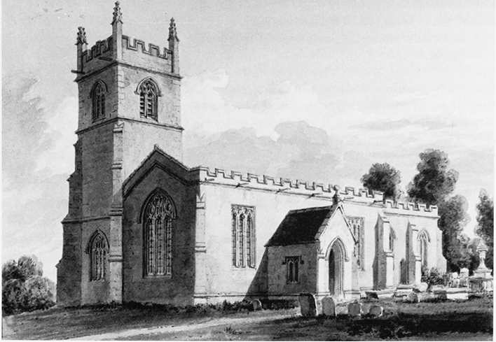
36. Parish church of St Leonard from the south-west, c. 1809.
Value and Property
In Minety there was both a rectory estate, (fn. 376) and a vicarage estate. In 1291 the rectory estate was valued at £26 13s. 4d. with profits of £6 13s. 4d. (fn. 377) In 1248 the tithes were worth 2 marks, (fn. 378) and in 1291 they were worth a total of £3 6s. 8d. (fn. 379) In 1340 the great tithes of grain, wool and lambs were worth £4. (fn. 380) In 1428 Minety church was assessed at 100s. and taxed at 6s. 8d. (fn. 381) Minety rectory was worth £6 annually in 1535. (fn. 382) In 1649 annual income from the Gloucestershire part of the parish was £55 and £4 from the vicarage house and glebe lands in Wiltshire: the great tithes of corn, grain and hay belonging to the rectory were worth £40. (fn. 383) In 1838 the tithes were worth £310, the tithes of the rectory estate were worth £5 and of the vicarage glebe £1. (fn. 384) By 1838 the great tithes had been sold and in that year tithe-rent charges were adjusted. (fn. 385) The rectorial tithe, worth c. £250 net in 1867, was transferred to the dean and chapter of Gloucester cathedral. (fn. 386) In 1939 the rectorial tithe, amounted to c. £177 annually. (fn. 387)
In 1535 the annual value of the vicarage estate, the great tithes of grain, wool, hay and the lesser tithes was £7 16s. 10d. (fn. 388) In the 17th century the vicar's glebe land included the churchyard, the adjoining 2 a. close and a ground in Flistritch field. (fn. 389) In 1663 the vicar received payments in kind and money for the lesser tithes and rent for the glebe. (fn. 390) In 1674 there was a tithe dispute between the vicar of Minety and the inhabitants of Oaksey, over the tithes on c. 6 a. of glebe land at Flisteridge in Braydon forest. The same enquiry also considered whether inclosures belonging to the lords of the manors of Garsdon and Grittenham were subject to vicarial tithes. (fn. 391) The income was so small it qualified for a supplementary investment of £200 from Queen Anne's Bounty in 1731 and the archdeacon of Wiltshire pledged an additional £12 annually. (fn. 392) In 1838 there were 10 a. of vicarial glebe land, (fn. 393) and in 1841 the living was valued at £120. (fn. 394) In 1843 the living was classed as a discharged vicarage, valued at £7 7s. 6d. with a net income of £166. (fn. 395) The vicar gave land from his glebe to the parish to build Minety Church of England School and schoolmaster's house in 1847. (fn. 396) In the later 19th century the vicarage had an annual value of c. £300. (fn. 397) In 1939 the vicarage was valued at £34 p.a. and there were 11 a. of glebe. (fn. 398)
The Vicarage House
Described as being in a poor
state of repair in the early 1550s, (fn. 399) by the 1670s the
vicarage house with its gardens apparently lay near the
churchyard. (fn. 400) The 'unfitness' of the vicar's glebe house
and the repairs which took place in 1840–1 forced the
incumbent to reside in Ashton Keynes. (fn. 401) The vicarage
stood on the site of what is now the church car park
until 1845. In that year a new vicarage was built, which
was altered in 1867, (fn. 402) and sold off to become a private
residence in the late 20th century. (fn. 403)
RELIGIOUS LIFE
Established Church
From 1276 services at Minety church were performed by a vicar appointed by the archdeacon of Wiltshire. (fn. 404) In 1304 a group of local men, who took over the church and the rectory estate on behalf of Peter of Savoy during a dispute, were excommunicated. Later the church was placed under an interdict and the parishioners were forced to attend Oaksey church until the matter was resolved. (fn. 405) In the mid 14th century the vicar and parishioners of Minety were recorded as processing around Minety moor chanting from the Gospels at the rogations before Pentecost. The moor was then being claimed by the abbey of Tewkesbury as appurtenant to the manor of Ashton Keynes and this was evidently an assertion that it belonged to Minety parish. (fn. 406)
In the 15th century an extensive scheme of stained glass was installed in the church windows, fragments of which have been fitted into the choir vestry screen. Those fragments, which include interlaced sickles and other heraldic devices associated with the Hungerfords, suggest they instigated the rebuilding and embellishment of the church. A north window, obliterated in the 20th century by the construction of a heating chamber, had the arms of Thomas Hungerford and his wife, and below it was a brass of Sir Nicholas Paulet (d. 1603), and his wife Mary who was a Hungerford; (fn. 407) a south window depicted a knight in armour, bearing the Hungerford arms, accompanied by three sons and three daughters in purple robes. Writing in the 1660s John Aubrey also noted the remains of the three kings of Cologne in a south window and armorial bearings of the Chiche and Clay families. He suggested that the seat of the lord of the manor was under that window and that the arms belonged to owners of Minety Court or to rangers or keepers of Braydon forest. (fn. 408)
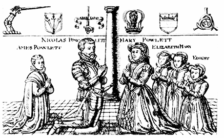
37. Funeral brass of Nicholas Paulet (d. 1603), in St Leonard's Church, painted by John Buckler, 1809.
By the early 16th century, when the tower was completed, the church had four bells. (fn. 409) In 1517 it had a high altar and several side altars. (fn. 410) Rent from small parcels of land maintained a hearse lamp or light for funerals, (fn. 411) and funded services in honour of the Virgin Mary. These practices were abolished at the Reformation, when the Crown confiscated 2 oz. of church plate, and sold off the parcels of land. (fn. 412) Only a chalice weighing 8 oz. was left for the use of the parish. (fn. 413) The church was given new furnishings in the early 17th century, including pews and a fine threedecker pulpit dated 1627, and the north aisle was reroofed. (fn. 414)
Minety's clergy were affected by the religious controversies of the interregnum: T. Leach, archdeacon of Wiltshire and rector of Minety in 1614, was listed among those clergy sequestered, or silenced in 1643; (fn. 415) Bernard Wayte, who became vicar of Minety in 1627, apparently lost his living. (fn. 416) Following the Restoration the church acquired a new chalice, dated 1663, which was in use together with pewter items in 1891, and in 2007. (fn. 417) The parishioners were reported to be reluctant to send their children to church despite the minister's attempts to explain the catechism each Sunday. (fn. 418) Parish registers survive from 1663 with details of marriages and burials and baptisms from 1673. (fn. 419)
The church invested in a new peal of five bells in the 1720s, (fn. 420) which were re-hung when the tower was restored in 1892, (fn. 421) and again, with a bell added, in 1958. (fn. 422) A Flemish brass chandelier was probably introduced later than its inscribed date of 1748 as it bears the names of two churchwardens not from Minety. (fn. 423) Religious observance was again poor in 1783. Although the curate took regular services, there were only four or five communicants at Easter. Children were catechised between Easter and Whitsuntide. (fn. 424)
An enquiry was made about repairs and reseating in 1846 but the 17th-century pews were retained. (fn. 425) Late in the 19th century piecemeal building work included reroofing the nave in 1884, restoring the tower and rehanging the bells in 1892, and lowering the pulpit to create a separate a reader's desk and part of new stalls. (fn. 426) Church life flourished under the Revd T. A. LudlowHewitt, vicar 1901–36, who was remembered warmly. A keen musician, he formed a church choir, which regularly won prizes for performances at local music festivals. Ludlow-Hewitt also organised major repairs and improvements to the church fabric, including the creation of a choir vestry in 1904. (fn. 427) The church tower was restored in 1906–7 with funds raised by public subscription. (fn. 428) Other repairs were made in the early 20th century. (fn. 429) In 1907 Col and Mrs Jones, parents of Mr Tudor Jones of Minety House, gave £52 10s. towards the underpinning of the church, (fn. 430) and C. C. Gouldsmith, a later resident of Minety House, put on fund-raising events for church repairs. (fn. 431) A sixth bell was added to the peal of five in 1958, (fn. 432) and further restoration work was needed in the 1960s. (fn. 433)
From 1987, the vicar of the new benefice of Ashton Keynes, Leigh and Minety lived at Ashton Keynes and in 2004 a trainee curate lived at Minety. (fn. 434) In 2007 services were held at Minety every Sunday, and church fellowship groups and a youth group attached to St Leonard's, held a range of regular activities in the local community. A church newsletter was distributed monthly around the parish. (fn. 435)
Nonconformity
Quakers were active in Minety in 1662 and in the early 18th century. (fn. 436) In 1676 there were 16 Protestant Nonconformists. (fn. 437) One Roman Catholic was reported in 1706. (fn. 438) In the 19th century a number of Nonconformist meeting houses were licensed. In 1812 Elizabeth Cove's house was licensed for religious worship. (fn. 439) Other residential houses were licensed for Baptist meetings in 1821, and in 1822 for Independent meetings. (fn. 440) At Sawyers Hill there were both Methodist and Baptist chapels. (fn. 441) A Primitive Methodist chapel was built in 1858. (fn. 442) It was renovated in 1916 with funds collected by the congregation. (fn. 443) It had been converted to a private residence by the early 21st century. (fn. 444)
A Strict Baptist chapel was established by 1840. It was inscribed 'Peculiar Baptist Chapel' allegedly because the builders made a mistake with the wording when it was rebuilt in the mid 19th century. The original building was wattle and daub with a thatched roof and stone floor. It was rebuilt with stone walls and a tiled roof. (fn. 445) In 1937 money was raised for work on the chapel and services were held in the band room at the Band Society while repairs were carried out. The congregation raised enough funds to maintain the chapel through collections, harvest festival sales, sacred concerts and 'special efforts' until the 1960s. In 1968 occasional Sunday services were still held there, but it closed soon after. The last burial in the graveyard took place in 1988. (fn. 446)
CHURCH BUILDING
St Leonard's church stands in Upper Minety. It has a nave with north aisle and chancel, a tower at the west end of the aisle, and a south porch. (fn. 447) The earliest evidence for a church on the site comes from fragments of an AngloSaxon cross shaft and an Anglo-Saxon oak tree coffin found there. (fn. 448) The present much-restored church dates mainly from the 14th and 15th centuries. The tower with battlements and pinnacles was built in c. 1517. (fn. 449) The nave has straight-headed windows and battlements on the south side, which also has an original traceried door; and the chancel also has battlements.
The chancel roof has moulded four-centred arches and head-corbels, (fn. 450) the north arcade has four bays and concave-sided octagonal piers and on the east wall of the north aisle is an angel corbel. There is an octagonal 15thcentury font, which is said to have been moved from the old parsonage house. (fn. 451) Tracery from a 15th-century screen has been reused on the present chancel screen and parts two 15th-century parclose screens enclose the east bay of the north aisle. (fn. 452) Fragments of the fine series of stained glass windows installed by the Hungerfords survive in a choir vestry window. (fn. 453) The present stained glass is 19th- and 20th-century, the east window a memorial to the Perry-Keene family. (fn. 454) Glazing in the south windows were renewed in the 1980s. (fn. 455) Sir William Penn (d. 1670), who founded Pennsylvania, was descended from William Penn of Minety, who is buried in the chancel near the south door. (fn. 456)