A History of the County of Wiltshire: Volume 6. Originally published by Victoria County History, London, 1962.
This free content was digitised by double rekeying. All rights reserved.
'The borough of Wilton: Introduction', in A History of the County of Wiltshire: Volume 6, ed. Elizabeth Crittall (London, 1962), British History Online https://www.british-history.ac.uk/vch/wilts/vol6/pp1-7 [accessed 30 April 2025].
'The borough of Wilton: Introduction', in A History of the County of Wiltshire: Volume 6. Edited by Elizabeth Crittall (London, 1962), British History Online, accessed April 30, 2025, https://www.british-history.ac.uk/vch/wilts/vol6/pp1-7.
"The borough of Wilton: Introduction". A History of the County of Wiltshire: Volume 6. Ed. Elizabeth Crittall (London, 1962), British History Online. Web. 30 April 2025. https://www.british-history.ac.uk/vch/wilts/vol6/pp1-7.
WILTON
The Anglo-Saxon founders of Wilton chose their site to meet the two-fold needs of defence and agriculture: west of Salisbury the long ridge, traversed by the great Ridgeway, and parting the valleys of the Wylye and the Nadder, drops down to a fertile level plain, and in the angle formed by the junction of these rivers the settlement was made. It was thus a settlement near rich agricultural land with the enclosing river system and nearby downland forming a natural fortification. Because of its site and proximity to a large monastic, later private, estate the town has always been limited in extent, never more than half a mile each way from the centre. The area of the parish in 1881 was 1,852 a., of which 25 a. comprised water. After the boundary changes, which enlarged the borough in the later 19th and earlier 20th centuries (see below) the total area was 2,676 a. (fn. 1)
The exact limits of the medieval town are not easy to determine, for the grounds of Wilton House have absorbed the southern suburb of Washern, and to some extent encroached on the town itself. Its western limit was marked by the hospital of St. John, Ditchampton, (fn. 2) which lies in West Street just outside the former West Gate, for the bounds of Grovely Forest came up to the hospital and no further. (fn. 3) From the West Gate the boundary was contained by the inner stream of the Wylye up to Cross Bridge on the one hand, and by the line of the Nadder up to Bull Bridge and the Bull Bridge Gate on the other. From Cross Bridge the boundary jutted out to the outer stream of the Wylye and then turned sharply south and south-east, skirting the former suburb of the Great Marsh to reach the Nadder in the south, whose course it followed up to Bull Bridge Gate. But this boundary cannot be fixed with precision.
The town together with its suburbs was of much more considerable extent, for these included Bulbridge, lying beyond the Bull Bridge Gate, Washern with South Ugford, the areas known as Great and Little Marsh, situated between the Wylye and Nadder to the east of the town, part of Fugglestone St. Peter, including Quidhampton and Burdens Ball, and Ditchampton. In the late 13th century South Newton was also regarded as one of these suburbs. Its history is not included in this volume, however, because it was a separate parish lying within the hundred of Branch and Dole, and its history belongs with that of the hundred. Fugglestone, as another separate parish in the same hundred, is also dealt with independently, but it is included within this volume (fn. 4) because its later history is inextricably linked with that of Wilton. The tithing of Quidhampton and the fee of Burdens Ball lay in Fugglestone and are described with the history of that parish, although by the early 19t century part of Burdens Ball formed a tithing in South Newton parish. At this date the chapelry of Ugford also lay in South Newton, and part of Ditchampton in South Burcombe, but details of their earlier history are mentioned here when more relevant to the history of Wilton. All the other medieval suburbs—that is, the manors of Bulbridge and Washern, the abbey manor of Ditchampton and the areas known as the Great and Little Marsh — were included within the parish of Wilton when it was united in the 16th century (fn. 5) and their history is inseparable from that of the borough.
Wilton was not included in schedules A or B of the Municipal Corporations Act of 1835. It was therefore denied the opportunity to secure a definition of its boundaries, although for parliamentary purposes, of course, those boundaries remained the same as they had been before the Reform Act. When it was re-incorporated in 1885, its boundaries were enlarged to include the Burcombe part of Ditchampton, and the parts of Fugglestone St. Peter and South Newton, which lay between the former South-Western railway station and Wilton itself, in addition to the whole ancient parish. In 1894 the parts of South Burcombe and South Newton within the borough were created separate parishes, known as Burcombe Within and South Newton Within, while the part of Fugglestone not within the borough was made into the separate parish of Bemerton. Later in the same year all the parishes within the borough were united for civil purposes into a single parish. The borough was enlarged again in 1934, when it acquired small parts of Bemerton, Burcombe, Netherhampton, and South Newton with a combined population of about 200. Before this enlargement the total population was 2,195, only 50 more than in 1801. There was a steady decline from 1801 until 1841, when the figure was 1,698, but it rose again to 1,804 in 1851. The population was almost stationary for the rest of the 19th and the first 30 years of the 20th century, because the slight increase after 1891 was mainly due to the enlargement of the borough. The most rapid increase was between 1931 and 1951, during which time the population rose to 2,858. Some of this increase was due to the establishment of the headquarters of Southern Command in the part of Wilton originally within Fugglestone, (fn. 6) but there were also a considerable number of new houses provided by the council during this period.
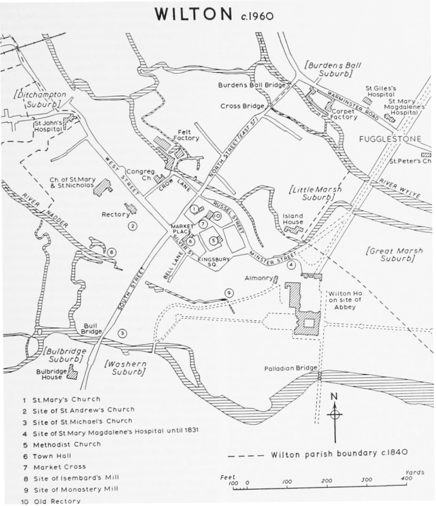
The medieval street plan of Wilton remains virtually unchanged, although some of the streets have been re-named within the last hundred years: (fn. 7) East Street is now North Street, and Frog Lane now Bell Lane. Kingsbury, the traditional site of the palace, linked by Minster Street with the former abbey, constituted the nucleus of the AngloSaxon settlement, but the centre of the later medieval borough lay at the intersection of the four main streets at Four Corners, and in the net-work of streets and lanes surrounding the Market Place and contained within the angle of Silver and South Streets.
Three churches surrounded the Market Place: (fn. 8) St. Mary's, Brede Street and Corn Street, stood on the north side of the square, and survives in a partly ruinous condition today; Holy Trinity faced the north side of the Guildhall, (fn. 9) but it disappeared during the 16th century; St. Nicholas in Atrio may have been situated on the south side, for it was eventually united with St. Michael's, Kingsbury, but its site cannot be identified. The Guildhall stood on the site of the present Town Hall: it was a twostory building with rows of shops underneath, a penthouse attached on the Market Place side, and an outside stairway on the northern side; nearby were the market stalls and shambles. A borough gaol existed by 1249, (fn. 10) and was ordered to be delivered in 1253–4, (fn. 11) 1280, (fn. 12) and 1284–5. (fn. 13) No further deliveries are known, but the prison itself remained in use. A keeper was appointed in 1322. (fn. 14) The town gaol, known in the 16th century as 'Brown's Bower', stood on the Kingsbury Square side of the Guildhall. (fn. 15) The market cross stood in the centre of the Market Place, and there the portreeve collected the tolls on behalf of the lord of the borough. (fn. 16) Dwelling houses faced the Market Place, and one of them was the home of the most prominent member of the 13th-century Jewish community of the town. (fn. 17)
By the 15th century the busy Market Place had fallen into decay and some of the streets and lanes leading off it had likewise decayed and disappeared, particularly in what must have been the earlier industrial quarter. Brede Street and Corn Street have been identified by their position in relation to the two churches of St. Mary and the Holy Trinity, (fn. 18) but the demolition of the houses on the south-east of Four Corners has obliterated the line of these streets. No attempt, however, can be made to identify Nedlers Street (almost certainly an industrial quarter), (fn. 19) Horenstreet, (fn. 20) or Glover Street, said to be in the neighbourhood of Mithilde Bridge; (fn. 21) all three streets were in existence at the end of the 13th century, but they do not appear to have been mentioned after this time.
By the end of the Middle Ages, and possibly earlier, the houses were mainly concentrated in a relatively small area well within the borough boundary; this more densely inhabited centre was surrounded by the meadows and marshes which lay along and between the rivers intersecting the town. The land on either side of East (now North) Street, known as Between Bridges, was mainly meadow land; beyond Crow Lane, with its mill and mill stream, known as Crow Mill Water, running alongside, were only withy beds; South Street was bisected by a stream running from Isembard's Mill in Mill Lane on the west side of the street down to Lovell's Mead and Monastery Mill on the east side. South of Mill Lane the millhams and rackmeads of Isembard's Mill joined those of the ancient Bulbridge Mill, which lay outside the borough, in a continuous succession of meadow lands intersected by many water courses; from Isembard's millrace up to the West Gate the outer limits of the borough were almost entirely meadow land.
The majority of the numerous churches of Wilton were naturally situated in the more densely populated parts of the borough. In addition to the three standing round the Market Place, there were at least six other churches within the borough: while South Street and East Street each contained only one church, the more populous West Street and Market Place contained the greatest number; and it was in West Street also that the Friars Preachers (fn. 22) built their church in the 13th century, and the attached meadow land, or Friars Mead, stretched towards Isembard's millrace.
The exact site of the abbey is not recorded, although it is reputed to have stood a little to the west of the later Wilton House. (fn. 23) If there is any truth in the legend that in Mary's reign the nuns returned to their former dwelling, (fn. 24) the building of the house, which was in progress by 1543, cannot have been the direct cause of the demolition of the abbey. Probably at the end of that reign, and certainly before c. 1568, the abbey buildings were destroyed, (fn. 25) with the exception of a building, still (1960) standing and known as 'the Almonry', which may have been the 'Bellhouse' court of the barony of Wilton. The hospital of St. Mary Magdalene stood opposite the abbey gate and the abbess's house stood to the south of the hospital, so that there is little difficulty in estimating the approximate site of the abbey, although its extent is not known.
In Saxon times the town was a natural centre of communications, linking the settlements which lay up the valleys of the Wylye, Nadder, and Avon. From Wilton the 'Port Herepath' (town highway) led through Bulbridge to South Burcombe, approximately along the line of the present road. (fn. 26) The road from South Damerham (Hants), which crossed the Ebble at Stratford Tony, was known as 'Wiltenweye', and presumably led ultimately to Wilton, although its immediate approach to the town has disappeared, possibly as a result of the inclosure of Wilton Park in the 16th century. (fn. 27) Another Saxon highway, known as 'Theod Herepath' (people's highway) led from Wilton across to the Avon valley via Lower Woodford. (fn. 28) The founding of New Salisbury temporarily gave Wilton a new importance, for, until the building of Harnham Bridge in 1244, (fn. 29) traffic coming from the west to the city had to make the river crossings at Wilton.
WILTON c. 1960
Early in the reign of Elizabeth I a survey made of Wilton and the other estates of William, First Earl of Pembroke, included a sketch map of the central part of the town. (fn. 30) This survey and map, together with a rental of 1598, revised for purposes of tax assessment in 1624, (fn. 31) provide data for the topography of the borough in the later 16th and early 17th centuries. The disappearance of the abbey although spectacular, was not the only change which had occurred, for the gradual decay of many buildings, above all churches, which had taken place in the course of the 14th, 15th, and 16th centuries had greatly altered the character of the town, leaving it with an empty and somewhat deserted air. The churches of the Trinity, St. Nicholas in Atrio, St. Michael's Kingsbury, St. Michael's South Street, St. Mary's West Street had all fallen into ruin or disappeared by c. 1568. (fn. 32) Many of the stones of the ruined churches were used for re-building and are visible today in some of the walls in South Street, where ancient chisel marks and sculptured stones can be identified. In 1548 permission was given by the mayor and his brethren for the repair of a decayed bridge and highway from building material from the church, (fn. 33) while in 1555 William Pountenay was expelled from the body of the burgesses for stealing three or four loads of ashlar from the church. (fn. 34)
In c. 1568 there were many tofts where houses had been demolished: 3 in East Street, 2 in South Street and 2 in West Street. Near the site of St. Michael's South Street the new tenant of Monastery Mill had built a barn; while shops which formerly had stood near the Bull Bridge had disappeared. (fn. 35) The meadow of the Friars Preachers, where houses had once been built, had been inclosed with a hedge by a wealthy clothier at the time of the Dissolution, and the houses had vanished. (fn. 36) Most of the houses which remained stood close together and their curtilages with orchards and gardens lay behind. They were still mainly concentrated in West Street and Kingsbury: the rental of 1624 listed 32 tenements in West Street, 28 in Kingsbury, 19 in South Street and 16 in East (now North) Street. (fn. 37) Nos. 25 North Street and 19 South Street are two small timber-framed medieval houses which have survived and can still be recognised in spite of later alterations. Both are of three bays, housed under a single roof, the central one originally an open hall, those at the sides of two stories. (fn. 38) In several refronted houses in West Street timber-framing is visible at the rear, suggesting that there may be medieval survivors here also. The Old Rectory, adjoining St. Mary's Churchyard, appears on the map of c. 1569 and may well retain medieval features behind its 18th-century brick front. It is evident, however, that by the 16th century there was little concentration of houses even at the centre of the borough and Leland writing of the Wilton of his day found a great contrast with its former greatness 'for afore Wiltown had twelve paroche churches or more, and was the hedde towne of Wileshir'. (fn. 39)
The c. 1568 survey and sketch also throws light on the local communications. A road, then old, had formerly led to Fugglestone; this road ran through Little Marsh, passing through the area now known as 'The Island', and continuing south of 'Crook Mead', an inclosed meadow still marked on the map of the 19th-century Inclosure Award. Apparently the road crossed the two streams of the Wylye by Mithilde Bridge and Fugglestone Bridge, and was called the Ystreet. (fn. 40) From Minster Street another road continued through Great Marsh to Quidhampton. Many small bridges, long since vanished, crossed the streams of the Wylye from Great Marsh: 'Huletesbridge' was frequently mentioned, (fn. 41) but the more important one was 'Walbornebridge', which linked Great and Little Marsh, not far from the abbey gate. (fn. 42) Even if any of these roads survived into the 18th century, none of them was ever turnpiked. Indeed, even the main roads—that is, the road from Salisbury to Warminster and the road branching from it at Wilton and going eventually to Mere — were not brought under the control of a turnpike trust until 1760. (fn. 43) In 1787–8 the road from Barford St. Martin to Whitesheet Hill was placed under another trust, and the trust which had managed the old Salisbury-Shaftesbury road along the downs lapsed; this marks the re-establishment of the route through Wilton which had fallen out of use after the building of Harnham Bridge in the 13th century. (fn. 44)
After the middle of the 17th century a process of rebuilding began which two hundred years later had obliterated nearly all traces of medieval Wilton although the street plan remained substantially unaltered. New bridges replaced most of the surviving but dilapidated medieval structures: in South Street the old Bull Bridge, long maintained by guild rents, had fallen into decay and the present triplearched bridge was built in the 17th century; while in the 18th century Cross Bridge and Burdens Ball Bridge in East (now North) Street were rebuilt in stone with twin arches and solid parapets, as they exist today. In the 17th century alterations were made to the medieval market cross in the Market Place, often called County Cross, although their purpose is not clear; upon the original base a column was built with four small balls supporting an urn or sundial, a purely decorative work which ignored the original use of the cross as a place for the collection of market tolls. Several 17th-century houses have survived, the earlier ones timber-framed such as the long thatched building, dated 1651, near the further end of West Street. The Chantry House to the south of Bull Bridge is a brick example dating from the late 17th century but with subsequent additions. A substantial house on the east side of South Street, perhaps built by a clothier, may also be of 17thcentury origin although its three-gabled front was altered after 1700. Another house which probably belongs to this century but which also received Georgian alterations occupies part of the south-west side of Kingsbury Square and is one of the few stone-fronted buildings in the town.
In 1738 a new Town Hall was built on the site of the former Guildhall. Traces of the original prison, however, remain on the Kingsbury side of the present Town Hall. Little is known of the medieval inns beyond the names of two of them, the 'Lion' in East Street, and the 'Saracen's Head'. (fn. 45) The 18th century witnessed the building of three of the inns of today, the Greyhound Inn in Kingsbury Square, the 'Wheatsheaf' in the Warminster road, and the 'Pembroke Arms' in Minster Street. Many of the larger houses of Wilton also belong to this century. Bulbridge House, beyond the bridge, is largely of 18th-century date but with a Regency addition. Almost opposite the entrance to Wilton House, the Island House is another fair-sized building of this period, while the Rectory in West Street has a fine late Georgian front of red brick with yellow brick pilasters and cornice. Many older houses were refronted at this time and a number of smaller ones were built, the latter consisting as a rule of twostoried cottages, their walls of brick, flint, or stuccofaced. Many of these, dating from the 18th and early 19th centuries, have survived — some in South and West Streets, more in Kingsbury Square, which, more than any other part of the town, presents a unified appearance. The centre of this square was planted with trees even in the Middle Ages and trees are clearly shown on the c. 1568 map, standing beside the old pound and stocks; the present pollarded limes continue this long tradition. Building of houses, some of which survive, also took place in the 18th century along the Shaftesbury road, while on the Warminster road the 18thcentury carpet factory was built.
The carpet factory, together with the development of other manufacturing interests, (fn. 46) undoubtedly helps to explain both the extensive building of artisans' dwellings, and of the larger more distinguished houses which characterized the period. A parish rate assessment of 1810 (fn. 47) shows the general distribution of smaller and larger houses, business premises, and workshops, which had to some extent transformed the appearance of the town. There were few small tenements, houses, or shops in Minster Street, but it contained some of the more considerable dwellings of the clothiers and brewers with offices and business premises attached. A new malt house had been built in addition to the old malt house. Cottages and gardens, the property of the Earl of Pembroke, had replaced the old buildings of the Magdalene Hospital. In Kingsbury Square clothiers had established three groups of offices, workshops and dye-houses, and they lived there alongside the gentry of the day in the more pretentious dwelling houses. Early-19th-century Kingsbury also contained some 15 shops together with 13 tenements, and 7 houses of less than £10 annual value. South Street and West Street including Crow Lane were essentially streets of small houses, with or without shops attached, together with workshops, combing shops, dye-and drying-houses. South Street contained 33 houses of under £10 annual value, together with 28 houses with shops attached, a fulling mill and many workshops; while in West Street, apart from the many workshops, there were 24 small houses and 19 houses with shops attached. The only sizeable house was that of the Congregational minister; the Congregational church, established in the early 18th century, together with its burial ground, lay in Crow Lane. (fn. 48) Penny's Lane and Bell Lane (the former Frog Lane) were of a similar character, but East (now North) Street with its 28 small houses and an equal number of houses with shops attached contained only one business house of any size.
The Inclosure Map of 1860 (fn. 49) shows that, despite the considerable building of the late 18th and early 19th centuries, much of what had constituted the medieval borough still consisted of meadow, pasture, and gardens. In the unusually long interval between the passing of the Act and its award some houses had been pulled down with little evidence of re-building, except for three or four houses in East Street. In South Street the Earl of Pembroke had acquired by exchange certain guild properties from the mayor and burgesses consisting of Londonderry House, and the tenements on each side of it; these had been taken down and the site thrown together with a large garden which lay behind, known in the medieval records as the 'void ground' of the mayor and brethren. Lord Pembroke had also acquired and demolished two more properties further down the street, and others on the north side.
Exchanges of property between the Rector of Wilton and Lord Pembroke, and between the rector and the Prior of St. John's Hospital served to enlarge the churchyard surrounding the new church of St. Mary and St. Nicholas; (fn. 50) and a tenement on the north-east corner of the churchyard, abutting on West Street, was demolished. The inhabitants of the hospital of St. Mary Magdalene were moved from the cottages on the site of the old hospital to six other cottages in Fugglestone. (fn. 51) Lord Pembroke also acquired by exchange the old burgage tenement belonging to King's College, Cambridge: the former 'Pembroke Arms' stood on this property in Minster Street; after the exchange it was taken down and the land inclosed within the Park. The present (1960) 'Pembroke Arms' stands on the opposite side of the street.
In the latter half of the 19th and during the 20th century much fresh building has taken place, but the areas developed have not been those of the old medieval borough. With the demolition of the buildings at the south-east corner of Four Corners, the Market Place has become a wide open space, with a new monument at the centre, slightly to the south-east of the old market cross; while with the building of the church of St. Mary and St. Nicholas in West Street, the old parish church of St. Mary, Brede Street and Corn Street has remained a partly-restored ruin, and its churchyard has become a public garden. (fn. 52) The many streets which formerly led off the square now appear as neglected lanes, where it is possible to trace them at all.
There has been some building in the 20th century on the former meadow lands on the south-east side of North Street. Outside the limits of the medieval borough expansion has been mainly to the northeast and north-west. The gas works built in 1854, (fn. 53) and closed in 1935, and the two Wilton stations, which served the former G.W. and L. & S.W. Railways stand on the far side of the Warminster road. The former G.W.R. station was closed in 1955. (fn. 54) The first reservoir and pumping station were built at Ditchampton. The cemetery, purchased c. 1890, lies on the south side of the Shaftesbury road. Along this road houses built between the two World Wars have followed a ribbon development. The council housing estates built after the First and Second World Wars respectively lie to the north-east and north-west of the centre of the town, and the senior school built in 1935 is also to the north at the Hollows. The council's most recent housing estate, however, is being built in 1960 on the south side of the town. A site between the Wylye and the Warminster road, once called the Hop Ground, was leased by the corporation from the Wilton House estate as a recreation ground and bowling green in 1912. (fn. 55)
Edward Slow, mayor of Wilton in 1892 and 1905, and for many years councillor and alderman, was a prolific author of poems and stories in the Wiltshire dialect, and also wrote a Chronology of Wilton. (fn. 56)
Wilton House. (fn. 57) Many of the Wilton Abbey lands and manors were granted to Sir William Herbert, later Earl of Pembroke, in 1541. (fn. 58) There is a tradition, but no proof, that he consulted Hans Holbein about the plans for the building of Wilton House. Holbein died in 1543, but the original quadrangled house, which was not completed until c. 1550, with two forecourts in front, was built on the lines which he may have suggested. (fn. 59) The entrance to the house was under an archway in the centre of the east front, through which coaches drove, to the inner quadrangle and thence by a porch to the north range which contained the Great Hall. The porch, known today as Holbein's porch, was in the early Renaissance style; at the beginning of the 19th century this building was removed to the garden by James Wyatt. The first survey of the Pembroke estates, made c. 1565–6, has a sketch of the house, which gives some indication of the early appearance of the present central portion of the east façade. (fn. 60)
Considerable additions were made to the original house in the early 17th century. Henry, the 2nd Earl, beautified and enriched the house, but it was chiefly on account of Mary Sidney, Countess of Pembroke, that Wilton House became so famous in this period. The countess and her brother, Philip Sidney, gathered around them an illustrious circle which, apart from the numerous royal and official visitors, included men such as Edmund Spenser, Philip Massinger the dramatist (1583–1640), member of an old Salisbury family, and Samuel Daniel. Aubrey described the house of this period as like a college, and noted the excellent library which was assembled during this time. The scientist, Adrian Gilbert, half-brother to Sir Walter Raleigh, was a frequent visitor, and he made the curious stone and brick wall on the west side of the Park, surrounding, according to Aubrey, 'Rowlington Park'. (fn. 61) In the first half of the 17th century the gardens were planned and there was extensive re-building of the house. The work was put in the charge of two Gascon brothers, Solomon and Isaac De Caux, and it is believed that they altered the south front of the house to bring it into harmony with the formal gardens, 400 ft. wide by 1,000 ft. long, which stretched over the Nadder. At the centre of these elaborate gardens was placed the great bronze statue of a gladiator, later removed to Houghton Hall (Norf.). Celia Fiennes, who visited Wilton in 1685, describes in some detail these formal gardens with their elaborate water devices. (fn. 62) In 1647, a disastrous fire destroyed almost all the house and contents. Shortly afterwards Inigo Jones, working in conjunction with John Webb, designed a new house, incorporating the Tudor centre of the east front which had survived the fire. The new south front contained a great series of seven state rooms, culminating in the Double Cube Room. In this wellknown room elaborate gilding and carving provided a fitting background to the great collection of Van Dycks which were brought there from London. John Evelyn recorded his impressions of Wilton House in a visit which he made in 1654: 'the most observable are the dining-room in the modern built part towards the garden, richly gilded and painted with story by De Creete; (fn. 63) also some other apartments, as that of hunting landscapes by Pierce; some magnificent chimney-pieces after the French best manner; also a pair of artificial winding-stairs of stone, and divers rare pictures. The garden (heretofore esteemed the noblest in all England) is a large handsome plain, with a grotto and water-works, which might be made much more pleasant were the river that passes through cleansed and raised, for all is effected by a mere force. It has a flower garden not inelegant. But after all, that which to me renders the seat delightful, is its being so near the downs and noble plains about the country and contiguous to it. The stables are well ordered and yield a graceful front, by reason of the walks of lime-trees with the court and fountain of the stable adorned with the Caesar's head'. (fn. 64)
For a short time during the Civil War Wilton House was garrisoned for the royalists: in October 1644, when the king advanced to Salisbury, he sent his great cannon on to Longford House and the rest to Wilton House, with a regiment of foot to guard them. (fn. 65) At the beginning of November a more permanent garrison seems to have been contemplated and a letter of the Parliamentary Committee of the Kingdom to the Committee of the Army stressed the danger of such a move. (fn. 66) In the negotiations leading to the Treaty of Uxbridge (1645) however, the Earl of Pembroke urged that it was reasonable to consent to all that Parliament had demanded, and it was alleged that Lord Pembroke would prefer that the king and his posterity should be destroyed rather than that Wilton should be taken from him. (fn. 67) Pembroke, at all events, did not suffer the loss of his estates during the Interregnum.
The 8th Earl formed a great collection of paintings and sculpture from Lord Arundel and Cardinal Mazarin, rare coins, and a notable collection of books. (fn. 68) Daniel Defoe described the house in 1722 as a museum of rarities with many fine paintings, for even the garrets contained good pieces; and he compared the house to the Luxembourg Palace in Paris. (fn. 69)
Henry, the 9th Earl, who succeeded to the title in 1733 and died in 1750, was known as the 'Architect Earl' and it was he who transformed the gardens into their present state. Evelyn had remarked on the great natural beauties of the landscape but at the time of the De Caux brothers this was not yet a factor to influence garden design. The course of the Nadder was deviated so as to run nearer the house, and spanned by the famous Palladian bridge, designed by Lord Pembroke and Roger Morris and completed in 1737. The east end of the Broad Water was also spanned by a bridge on which was placed a casino with a richly carved façade; eventually this casino was removed from the bridge and part of it still stands in the garden. From the Palladian bridge the landscape was unified and balanced by a triumphal arch, surmounted by a statue of Marcus Aurelius, set on the summit of a hill, with a classical temple set a little to the west below the brow of the hill, both designed by Sir William Chambers. The arch was later moved by James Wyatt to form the main entrance to the north forecourt of the house. (fn. 70)
The 10th Earl, also Henry, was a cavalry officer and he was responsible for the building of the riding school after the model approved by the continental riding master, Baron Eisenberg. It was built of brick and was set at the north-west corner of the house; kitchens and other quarters were made in it by James Wyatt, who carried out many alterations at Wilton between 1801 and 1814. He pulled down the north and west fronts of Inigo Jones, and built instead pseudo-Gothic façades with windows in the style of Salisbury Cathedral; he also removed the rooms on the west side to make room for a library, and reduced the size of the inner quadrangle by building a two-storied cloister round the house. The cloisters undoubtedly serve a useful purpose, but between 1913 and 1918 most of the other alterations were undone. The Gothic façade was removed from the north front, and the porte-cochère replaced by a Renaissance-style entrance. Thus despite much re-building and alteration, the form of the present quadrangled house is not greatly different from that originally conceived in the 16th century.
About ¼ mile to the south-east of Wilton House is Washern Grange, a group of buildings incorporating a large 14th-century barn which must originally have been one of the farm buildings of Wilton Abbey. In 1567 it was described as a large grange called Washern Barn containing ten bays of building and roofed with tiles. It was then used for storing grain and hay. At the same date there was apparently a stable for 80 horses adjoining the barn, and barn and stable with the courtyard then covered one acre. (fn. 71) In c. 1632–5 the De Caux brothers, in the course of their work at Wilton, are said to have rebuilt the stable court, retaining the barn on its east side. (fn. 72) When new stables were built nearer to Wilton House in the 18th century part of these 17th-century buildings were pulled down. (fn. 73) The group now consists of a square courtyard, the original barn consists of a square courtyard, the original barn with its stone buttresses and trussed-rafter roof forming the east side. The north range is of brick with stone dressings, having an arcaded front with circular windows above; it is flanked by two pavilions, one of which was enlarged in the late 19th century to form a small house. (fn. 74) The west side of the court now consists of an open arcade, while the barn wall opposite is faced with brick to match the style of the other buildings. A coach-house projects into the court in the centre of the south range.