A History of the County of Wiltshire: Volume 8, Warminster, Westbury and Whorwellsdown Hundreds. Originally published by Victoria County History, London, 1965.
This free content was digitised by double rekeying. All rights reserved.
'Teffont Magna', in A History of the County of Wiltshire: Volume 8, Warminster, Westbury and Whorwellsdown Hundreds( London, 1965), British History Online https://www.british-history.ac.uk/vch/wilts/vol8/pp74-78 [accessed 27 July 2024].
'Teffont Magna', in A History of the County of Wiltshire: Volume 8, Warminster, Westbury and Whorwellsdown Hundreds( London, 1965), British History Online, accessed July 27, 2024, https://www.british-history.ac.uk/vch/wilts/vol8/pp74-78.
"Teffont Magna". A History of the County of Wiltshire: Volume 8, Warminster, Westbury and Whorwellsdown Hundreds. (London, 1965), , British History Online. Web. 27 July 2024. https://www.british-history.ac.uk/vch/wilts/vol8/pp74-78.
In this section
TEFFONT MAGNA
FOR most of its history Teffont Magna, or Upper Teffont, has been a chapelry of Dinton. (fn. 1) Ecclesiastially it remained dependent upon Dinton until 1922, (fn. 2) but in the earlier 19th century it seems to have been regarded as a parish for certain administrative purposes. (fn. 3) In 1934 it was joined with Teffont Evias to form the civil parish of Teffont. (fn. 4) The ancient parish contained 1,734 a. (fn. 5) and extended about 2½ miles from north to south, and a mile from east to west. The Grovely Grim's Ditch formed its northern boundary, and the southern boundary ran along the present (1962) main road between Dinton and Teffont Magna as far as the Black Horse Inn. It then left the road and proceeded westward for about ½ a mile skirting Upper Holt Copse before turning north and running up to Grim's Ditch. (fn. 6)
Much the greater part of the ancient parish lay on the chalk downs that rise between the valleys of the Wylye and the Nadder. On top of the downs, in the extreme north of the ancient parish, the land reaches nearly 600 ft. It then falls gently southwards to a height of about 300 ft. on the lower chalk, but rises again to 450 ft. on the ridge of upper greensand that borders the chalk. At Springhead, towards the foot of the downs, a stream emerges from the chalk and forms a shallow valley through the greensand ridge as it flows southwards through the village to join the Nadder ½ mile beyond the boundary of the ancient parish. (fn. 7) The sandy land is well wooded on the Common, to the east of the stream, and at Upper Holt Copse to the west. Thickthorn Wood on the downs is the most westerly offshoot of Grovely Wood and in 1567 covered about 10 a. (fn. 8)
Neolithic and Bronze Age implements have been found on the downs behind the village, and finds indicating Roman occupation have been made at Upper Holt Copse. (fn. 9) The land of the ancient parish, being mostly chalk, was devoted mainly to sheepand corn-farming. (fn. 10) The parish boundary stopped short of the River Nadder by about ½ mile, so that Teffont Magna had but a small share of the clay and loam soils of the valley, and consequently could not exploit to the same extent the watermeadows which contributed so much to the farming of its neighbour, Dinton. (fn. 11) Perhaps this dearth of rich pasture land explains in some measure the interdependence which existed between the farming of the two manors of Dinton and Teffont Magna in the Middle Ages. In the 20th century this lack of naturally rich pasture has been overcome with the widespread use of fertilizers and mixed farming on the chalkland has become possible.
It is impossible to estimate the population of Teffont Magna before the 19th century. The chapelry contributed 100s. to the 15th of 1334 when Dinton contributed only 6s. more, and in 1377 there were 75 poll-tax payers in Teffont and 156 in Dinton. (fn. 12) In 1543 there was only one inhabitant of sufficient substance to contribute to the benevolence of that year while in Dinton there were 6, and in 1576 there were 12 taxpayers in Teffont and 18 in Dinton. (fn. 13) When the Census figures begin in 1801 the population of Teffont Magna was 199. It rose to 292 in 1881 but thereafter dropped until it reached 172 in 1931. In 1951 after Teffont Magna had been joined with Teffont Evias, the population of the parish of Teffont so formed was 297. (fn. 14)
The Roman road from the Mendip lead mines to Old Salisbury passes through the extreme north of the parish (fn. 15) and the green-way, called the Ox Drove, of possibly greater antiquity, runs in roughly the same direction just south of it. Until about the mid-19th century the main road from Salisbury to Hindon was that running along the top of the sandy ridge, north of Dinton village, and entering Teffont Magna almost opposite the church. (fn. 16) This road was turnpiked in c. 1760. (fn. 17) From the south, the village was approached either by the road running through the village of Teffont Evias, or by a track which led from Dinton across Teffont Common. (fn. 18) At the beginning of the 19th century the present (1962) main road between Dinton and Teffont Magna skirting the Common was made. (fn. 19)
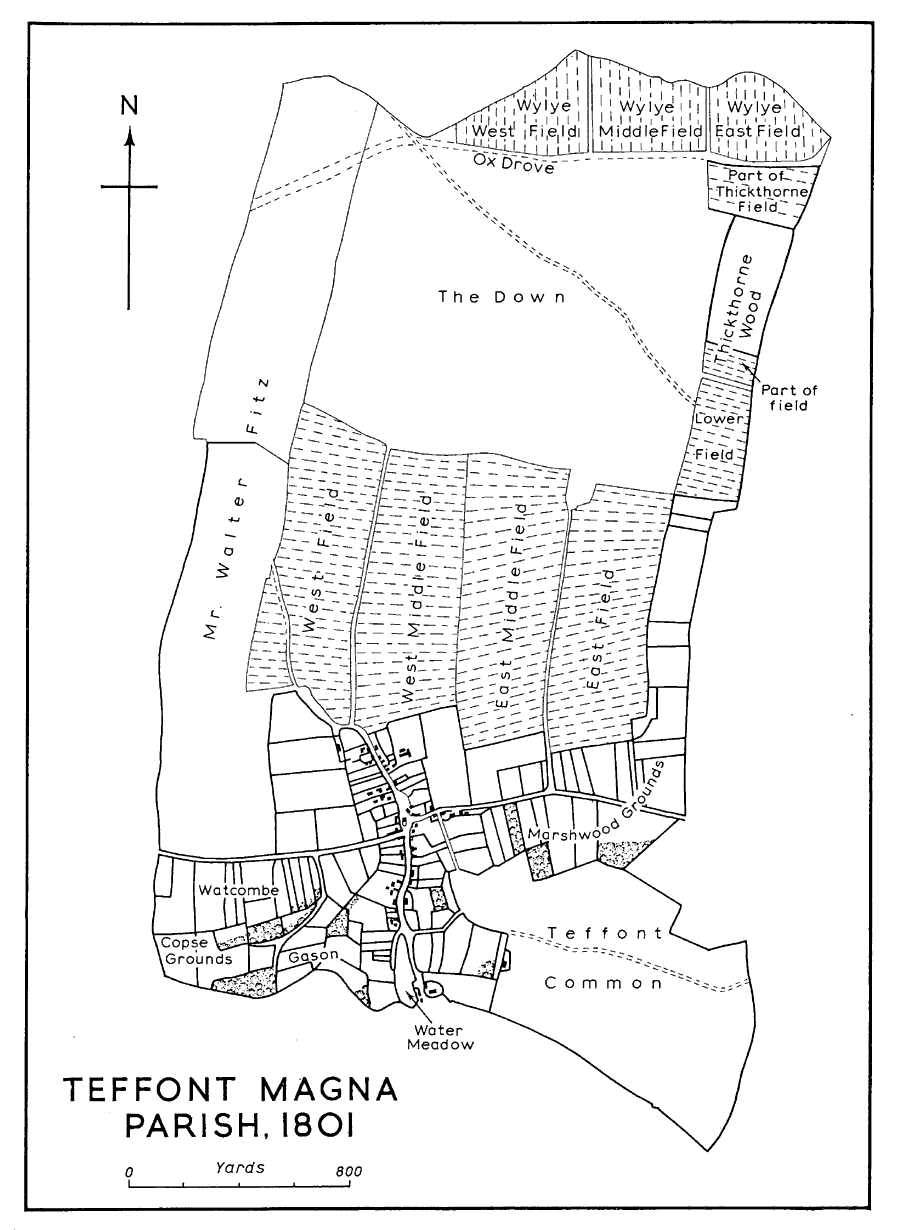
Teffont Magna Parish, 1801
Based on a map of the manor made for Lord Pembroke by John Charlton
The village lies along the main road and along the road which leads north from it towards the downs. Several of the cottages are built on the bank of the swift-flowing stream which borders the road and have stone bridges spanning the stream to the road. Many of them date from the 17th and 18th centuries and are built of local stone, and some in 1963 retained their thatched roofs. Few of the houses are larger than cottages. North-west of the church the house called (in 1962) Buck's Close was probably originally a small farm-house. In the late 19th and early 20th century it was an off-licence public house known as 'The Hole in the Wall', and a part of it was used as a malt house. (fn. 20) In 1962 it was a private house. Fitz House, the largest house in Teffont Magna, to the west of the village street, was a farm-house until the 1920's. The house, with an adjoining barn on the north, approximately covers three sides of a square. The main house, of squared rubble with dressed quoins and stone mullioned windows, is of late 16th- or early 17th-century date. In 1700 a projecting wing was added at the south end of the main house. This, which bears a tablet inscribed 'R. Fitz 1700', was originally built as a store house, according to local tradition, for wool, (fn. 21) and it was not converted for domestic use until the 20th century. (fn. 22) The 'Black Horse', an early 18th-century building with stone mullioned windows, at the south end of the village was also once a small farm-house. It became an inn in the 19th century after the present main road between Dinton and Teffont Magna was made. (fn. 23) An inn of the same name stood on the south side of the old turnpike road just as it left the village for Dinton. This 17th-century house of stone with thatched roof became a private dwelling when this road ceased to be a main road. (fn. 24) Manor Farm, the largest farm in Teffont Magna, lies to the north of the village at the foot of the downs. The farm-house is of early 19th-century date. The cottages beyond the farm at Springhead were built by the Pembroke Estate in the mid-19th century. (fn. 25) Apart from a few privately built bungalows, there has been very little building in the village in the 20th century and in 1962 there were no council houses. In c. 1896 water was piped from Springhead and brought to the village by standpipes at intervals all the way down the road. (fn. 26) Main water supply came to the village in 1962. (fn. 27)
MANOR.
Two charters relating to land in 'Teffont' are included in the 15th-century cartulary of Shaftesbury Abbey. (fn. 28) The earlier, dated 860, is a grant by King Æthelbald of 14 cassati to Osmund, a thegn. (fn. 29) The other is a grant by King Edgar of 5 cassati to his thegn Sigestan in 964. (fn. 30) It is not known to precisely what area of land these two charters relate, but they presumably represent Shaftesbury's title to the manor of TEFFONT MAGNA which it acquired some time before the Conquest. Teffont Magna is not mentioned in the Domesday Survey and is most probably included under Dinton, also a Shaftesbury Abbey manor. (fn. 31) It was treated as a part of Dinton throughout the Middle Ages and after the Dissolution passed with Dinton to William Herbert, later Earl of Pembroke (d. 1570). (fn. 32) The manor continued to descend as Dinton with the Pembroke title until 1919 when it was sold to Lord Bledisloe (cr. Viscount Bledisloe 1935). (fn. 33) In 1950 Lord Bledisloe's son, the Hon. Charles Hiley Bathurst, sold the estate to the Hon. J. J. Astor who sold it the following year in lots. (fn. 34)
Until the mid-17th century the demesne lands in Teffont Magna were considered part of the Dinton manorial estate and were farmed with that estate. (fn. 35) In 1650 the Teffont lands were leased separately for the first time when the lessee was John Rawlins. (fn. 36) In 1679 Richard Maddox was the lessee, and he was followed by his sons, Nathaniel and Samuel. (fn. 37) In 1705 the lease was assigned to Joseph Mould who was succeeded in Teffont by his sons, Joseph and John. (fn. 38) In 1781 the lease was granted to Oliver Smith and he, or a son of the same name, was still farming the lands in 1836. (fn. 39) The farm had a number of lessees in the later 19th century and until it was sold in 1919. (fn. 40) It was then bought with the rest of Lord Pembroke's lands in Teffont Magna by Lord Bledisloe, but Lord Bledisloe sold the farm, called Manor Farm, almost immediately to the tenant farmer. (fn. 41)
LESSER ESTATES.
Among the freeholders on the combined manor of Dinton and Teffont in 1567 two were said specifically to hold their lands in Upper Teffont. (fn. 42) They were Leonard Newe, and Thomas South, who also had a freehold estate in Dinton. (fn. 43) The South estate in Dinton passed in the late 17th century, as has been shown elsewhere, (fn. 44) to William Wyndham and the lands in Teffont were included in the conveyance. In 1567 the Teffont lands comprised 2 virgates called Westbyes and 4 called Sawcers. (fn. 45) The descent of Leonard Newe's estate has not been traced. The first mention found of the Fitz family in Teffont Magna is in 1656 when Walter Fitz conveyed land there to John Baverstock, a tailor. (fn. 46) In 1736 a descendant, Walter Fitz, was the most substantial freeholder in Upper Teffont. (fn. 47) By the beginning of the 19th century the Fitz estate lay in a compact block along the west side of the ancient parish, (fn. 48) and in 1837 comprised 286 a. (fn. 49) Towards the middle of the 19th century the estate was sold to William Wyndham (fn. 50) and remained part of the Wyndham estate in Teffont and Dinton until it was sold in c. 1920 to Lord Bledisloe. (fn. 51) It was sold with the rest of Lord Bledisloe's property in Teffont Magna in 1950. (fn. 52)
ECONOMIC HISTORY.
Teffont Magna is not mentioned in the Domesday Survey but was almost certainly included under the survey of Dinton. (fn. 53) It was indeed farmed by Shaftesbury Abbey as part of Dinton throughout the Middle Ages. No separate medieval surveys for Teffont Magna exist and its tenants are included in the mid-12th-century survey for Dinton contained in the early-15th-century Shaftesbury Abbey cartulary. (fn. 54) This shows some tenants with lands on both manors. The interdependence of the two estates is further emphasized by the fact that there was no mill at Teffont Magna and corn from there had to be ground by one of the Dinton mills. (fn. 55) Teffont Magna is not named among the lands of Shaftesbury Abbey in the Valor Ecclesiasticus and was again, no doubt, included under Dinton. (fn. 56)
It was surveyed with Dinton in 1567, shortly after both estates had passed to Lord Pembroke, and from this survey some information may be had about the agricultural organization of Teffont Magna as a separate unit. (fn. 57) At this date there was no separate demesne farm there. Teffont Magna had, however, its own three open arable fields and in these lay some 80 a. of Dinton's demesne arable. The Dinton demesne farm also had a small amount of meadow in Teffont and grazing for 300 sheep on Teffont Down. Of the seven freeholders, whose holdings are precisely located in this survey, two appear to have had lands in Teffont Magna and two in both Dinton and Teffont. The survey rarely locates the holdings of the customary tenants on the two estates, but, in the few cases where these are stated to be in Teffont Magna, they comprised a few small closes of meadow, an allotment of strips in the three common arable fields, and certain grazing rights for sheep and other beasts on the downs.
A survey of 1631 provides more information since the tenants of Upper Teffont are separately listed. (fn. 58) There was still no demesne farm, and the demesne farm of Dinton had 66 a. in Teffont's common fields, about 9 a. of meadow in the chapelry, and certain rights to fuel from Teffont Common. As in 1567, Dinton's demesne arable at Teffont was distributed among the open fields and was not, as it was by then in Dinton, consolidated into a single field. Inclosure was, however, proceeding, and was specifically given as the reason for the decline in the number of sheep that could be grazed upon the downs. Fifteen customary tenants are named at Upper Teffont, all holding by copy of court roll. Most, by this date, had small closes of arable, as well as their closes of meadow and their uninclosed strips in the common fields. Nearly all had, besides their grazing rights on the downs, an acre or so in Thickthorn Wood.
In 1650, for the first time, the demesne lands in Teffont Magna were leased as a separate estate. (fn. 59) They comprised a small close of arable in which stood a barn, a coppice, another small close, and 66 a. of arable in the common fields, namely 22 a. in West Field, 28 a. in Middle Field, and 16 a. in East Field. There was also grazing on the downs for 270 sheep and an allotment out of Teffont Common for fuel. There was a dwelling house attached to the estate. (fn. 60) Henceforward the Teffont demesne lands formed a separate estate which later was enlarged and became known as Manor Farm.
A map of 1801 shows the open fields still in being, although the three-field system had been slightly modified by a certain amount of subdivision. (fn. 61) The manor farm at about this time had 47 a. of inclosed arable and just over 100 a. of arable distributed between the three fields. Walter Fitz, the largest freeholder, had 32 a. of inclosed arable and 124 a. said to be in the common fields, but they had been largely consolidated in one field along the western boundary of the parish. (fn. 62) Consolidation of the rest of the lands was achieved by the joint Inclosure Award for Dinton and Teffont Magna in 1837. At this time Lord Pembroke's manor estate comprised 823 a. and his leasehold estate 282 a. William Wyndham had a freehold estate in Teffont Magna of 228 a., and other freehold estates there, including that of Walter Fitz, amounted to 309 a. (fn. 63)
In the 20th century the productivity of the chalk lands of Teffont Magna has been at least doubled by the use of artificial fertilizers. (fn. 64) The lack of much of the more inherently fertile lands along the river has thus been largely overcome. In 1956 there were two farms within the area of the ancient parish. Manor Farm, with over 1,000 a., had dairy and beef cattle, pigs, sheep, and a large number of chickens, and turkeys. Fitz Farm was also a mixed farm. (fn. 65) Agriculture has always been virtually the only employment available within Teffont Magna.
CHURCH.
The church of Teffont Magna was a chapel-of-ease of Dinton until 1922 and its history until then has been recorded with that of the church of Dinton. (fn. 66) No endowments were specifically allotted to Teffont Magna and the chapel was always served either by the Vicar of Dinton or by his curate. In c. 1870 a house was built in Teffont Magna so that the curate could live there. (fn. 67) In 1922 the chapel of Teffont Magna was detached from the church of Dinton and annexed as a chapelry to the church of Teffont Evias. (fn. 68) The chapel was then served by the Rector of Teffont Evias and the advowson of the church of Teffont Evias was shared by M.W. and G.F. Keatinge and the patrons of the church of Dinton. (fn. 69) In 1957 the advowson of Teffont Evias was transferred to the Bishop of Salisbury, already by then patron of the church of Dinton. (fn. 70) Since 1952 the church of Teffont Evias with the chapelry of Teffont Magna and the church of Dinton have been held in plurality. (fn. 71)
The church of Teffont Magna has no known dedication. It is a small rectangular building of local stone. It is mainly late 13th century in date, but fragments of a Saxon cross-shaft found reused in the walls suggest the possibility of an earlier church on or near the same site. The south porch was added in the 14th century and the jambs of the south doorway have representations of medieval ships scratched upon them, an unusual subject for an inland church. (fn. 72) The nave and chancel are structurally undivided but between them is a screen, probably of early 16th-century date. There is a 13th-century circular font bowl and on the south side of the chancel there was, in 1963, a 17th-century communion table. The church was restored in 1955. There is an Elizabethan cup with hall marks for 1571 belonging to the chapelry and a paten of pre-Reformation date. (fn. 73) One of the two bells was removed from the bell-cote in the west wall in 1930 and placed within the church. This is a narrow-waisted bell with no mark but thought to date from the late 13th century. (fn. 74) The present No. 1 bell was given to the church in 1947 and No. 2 bell, dated 1764, was recast at the same time. (fn. 75) Record of births, deaths, and marriages was kept in the registers of Dinton until 1852 when separate registers for the chapelry were begun. No ground was consecrated for burials until 1925. (fn. 76)
At the time of Dinton and Teffont Inclosure Award two small pieces of land lying ¾ mile north of the church were allotted to the chapel-wardens. (fn. 77) These were called Bell Halves and Bar Acre and the rent from them, which was 30s. in 1925, (fn. 78) was used for the general expenses of the church. In 1959 authority was given for the land to be sold. (fn. 79)
NONCONFORMITY.
In 1783 there were said to be no dissenters in the chapelry. (fn. 80) About 30 years later two houses in the village were licensed as nonconformist meeting places (fn. 81) and in c. 1820 a Primitive Methodist chapel was built. (fn. 82) In the later 19th century the Vicar of Dinton attributed the decline in the congregation from Teffont Magna to the successful activities of the nonconformists in the chapelry. (fn. 83) In 1905, however, the Primitive Methodist chapel ceased to be used and was closed. (fn. 84) It was subsequently converted into a private dwelling house.
SCHOOL.
In the early 19th century children from Teffont Magna attended the school in Dinton. (fn. 85) By 1859 there was a school in the village conducted by a dame in a roadside cottage and attended by about 40 children. (fn. 86) The National Society was giving support to a village school by 1871. (fn. 87) Some time before 1881 this school received a building grant from the Treasury. (fn. 88) In 1893 average attendance was 52. (fn. 89) The school was closed in 1936 and the children have since attended schools in Dinton or Wilton. (fn. 90) In 1962 the former school building was used for village meetings and social activities.
CHARITIES.
By his will proved in 1836 John Lush gave £50 to provide blankets every year for the two oldest poor in the chapelry. In 1906 the income from the investment was 25s. and 6 blankets were distributed. (fn. 91) In the 1950s the income of this charity was the same and was allowed to accumulate until a reasonably large sum was in hand. (fn. 92)
Edward Harris by his will proved in 1876 left £100 to provide coal at Christmas time for the poor of Teffont Magna. Subsequently the income on this was used as a donation to the parish coal club. (fn. 93) In 1952 it was spent on coal for 10 persons. (fn. 94) A scheme was drawn up in 1928 for the administration of this charity with that of John Lush (see above). By this the incumbent and two representatives of the parish council became trustees. (fn. 95)