Ancient and Historical Monuments in the County of Gloucester Iron Age and Romano-British Monuments in the Gloucestershire Cotswolds. Originally published by Her Majesty's Stationery Office, London, 1976.
This free content was digitised by double rekeying. All rights reserved.
'Coberley', in Ancient and Historical Monuments in the County of Gloucester Iron Age and Romano-British Monuments in the Gloucestershire Cotswolds(London, 1976), British History Online https://www.british-history.ac.uk/rchme/ancient-glos/pp33-34 [accessed 30 April 2025].
'Coberley', in Ancient and Historical Monuments in the County of Gloucester Iron Age and Romano-British Monuments in the Gloucestershire Cotswolds(London, 1976), British History Online, accessed April 30, 2025, https://www.british-history.ac.uk/rchme/ancient-glos/pp33-34.
"Coberley". Ancient and Historical Monuments in the County of Gloucester Iron Age and Romano-British Monuments in the Gloucestershire Cotswolds. (London, 1976), British History Online. Web. 30 April 2025. https://www.british-history.ac.uk/rchme/ancient-glos/pp33-34.
COBERLEY
(9 miles N.W. of Cirencester)
(1) Hill-fort (SO 927161), Crickley Hill, is a promontory enclosure of some 9½ acres, contained by a single rampart and ditch with occasional traces of a further ditch beyond. Within it a Neolithic earthwork cuts off about 3 acres at the tip of the Inferior Oolite spur. Axially the interior is almost flat between the Iron Age and Neolithic earthworks, but it rises gently W. from the latter; on either side of the axis there is a gentle slope down to N. and S. The N. edge comprises a very steep natural slope, now partly quarried. The S. edge has a similar sharp shoulder towards the W., but quarrying over most of this side has resulted in sheer cliffs.
Excavations begun in 1969 by Mr. P. Dixon indicate that the hill-fort dates from the beginning of the Iron Age and that there was occupation and some use of the rampart area in Roman times.
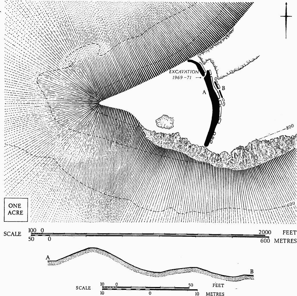
Coberley. (1) Hill-fort on Crickley Hill. Plan and profile.
The first phase is represented by post-holes and a rockcut drain, which underlie the rampart. The phase-2 fortification took the form of a timber-laced rampart with facing walls about 23 ft. apart. A berm some 2 ft. to 5 ft. wide lay between the rampart and a flat-bottomed ditch, about 24 ft. across and originally 6 ft. deep. There was an entrance with front and rear gates. Aligned on either side of the road from the entrance were rectangular timber buildings in the form of aisled halls, each about 24 ft. wide and ranging in length from 28 ft. to 80 ft. Two had central hearths. Associated pottery was coarse and undecorated. The buildings and the rampart had been burnt. In phase 3 the defences were rebuilt, perhaps in two stages. Solid bastions with irregularly curved walls flanked the gate, which was further protected by an out-turned hornwork with similarly curving walls and with its own ditch built partly over the pre-existing ditch. The original ditch was further modified by the construction, on the floor near the inner side, of a revetment wall retaining a rubble core between itself and the former line of the rampart. The ditch was widened on the outer side to a total of 40 ft. (Plate 40). In the interior a circular building replaced those of phase 2; it was 48 ft. in diameter and had a central hearth and a porch facing west. Pottery associated with this building and with the reconstructed rampart includes sherds with incised chevrons and white inlay. This phase also ended with an intense fire; afterwards the rampart entrance was not reconstructed. Evidence for occupation in the Roman period includes metal-working in the silted ditch and gateway.
C.U.A.P., OAP AIN 52–8.
P. Dixon, Crickley Hill: Third Report, 1971 (Committee for Research into the Iron Age in the North West Cotswolds, 1971). Antiquity, XLVI (1972), 49–52; XLVII (1973), 56–9.
(2) Probable Settlement, Romano-British, in Short Wood, is indicated by finds at two points. Two tesserae were found in a paved area (so 93101642) beside the corner of a boundary dyke, itself probably post-Roman. Other finds, including samian ware, come from a point ¼ mile N.N.E. (SU 93351680).
TBGAS, 83 (1964), 40–8.
(3) Romano-British Settlement (SU 967152), extending over about 12 acres on ground sloping gently W. to a steep edge, lies some 50 ft. above the R. Churn, between two re-entrant gullies down which springs occasionally send water. The ground between the gullies is almost flat and is demarcated on the S. by a sharp stone-covered scarp, up to 5 ft. high. Here, in an area measuring about 200 yds. E.-W. and 70 yds. N.-S., there are traces of platforms, spread rubble (some in lines), and a notable concentration of other debris including flue and roof tiles, fragments of pilae, tesserae and large quantities of sandstone. Lesser concentrations occur over most of the remainder of the modern arable field; they extend as far as the road on the E., but end sharply along the S. re-entrant gully. Small finds include samian and mortaria fragments, and painted plaster.
Information from Mrs. E. Gander, who drew our attention to the site.