Ancient and Historical Monuments in the County of Gloucester Iron Age and Romano-British Monuments in the Gloucestershire Cotswolds. Originally published by Her Majesty's Stationery Office, London, 1976.
This free content was digitised by double rekeying. All rights reserved.
'Dowdeswell', in Ancient and Historical Monuments in the County of Gloucester Iron Age and Romano-British Monuments in the Gloucestershire Cotswolds(London, 1976), British History Online https://www.british-history.ac.uk/rchme/ancient-glos/pp43-44 [accessed 30 April 2025].
'Dowdeswell', in Ancient and Historical Monuments in the County of Gloucester Iron Age and Romano-British Monuments in the Gloucestershire Cotswolds(London, 1976), British History Online, accessed April 30, 2025, https://www.british-history.ac.uk/rchme/ancient-glos/pp43-44.
"Dowdeswell". Ancient and Historical Monuments in the County of Gloucester Iron Age and Romano-British Monuments in the Gloucestershire Cotswolds. (London, 1976), British History Online. Web. 30 April 2025. https://www.british-history.ac.uk/rchme/ancient-glos/pp43-44.
DOWDESWELL
(11 miles N. of Cirencester)
Three 'camps' have been suggested in this parish, but only one of them can be accepted as a hill-fort of Iron Age date (see p. xxxiii).
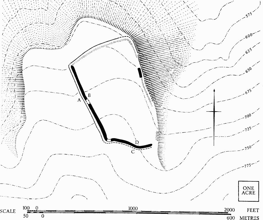
(1) Hill-fort (SO 999191), on Dowdeswell Hill, formerly called 'The Castles', (fn. 1) univallate, unexcavated, encloses 14½ acres of the E. side of a spur projecting N. from Dowdeswell Hill at about 700 ft. above O.D. The rampart has been extensively damaged on all sides except part of the S.W. The ditch has been filled on the S. and it appears to have slipped downhill on the steep E. side. The interior has been ploughed, perhaps since mediaeval times, accounting for the division of the area into two parts (Plate 38). A surface scatter of Romano-British potsherds is particularly noticeable in the N. half.
Dowdeswell. (1) Hill-fort on Dowdeswell Hill.
Dowdeswell. (1) Hill-fort
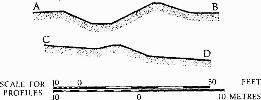
Profiles (plan, p. 43).
The rampart, where best preserved on the S.W., is 23 ft. across, 4 ft. above the interior and 8 ft. above the ditch fill. The ditch, 25 ft. across the top, has been disturbed by use as a track. On the N.W. side the ditch has been largely filled in, but there is a suggestion of a slight counter-scarp bank. On the E. side the bank has been almost totally levelled, but a terrace marking the line of the ditch extends S. for 450 ft. from the N.E. angle. Beyond this point the terrace extends outwards and downwards until, 700 ft. from the angle, it is 20 ft. below the scarp which marks the edge of the interior, and 50 ft. E. of it. The original entrance appears to have been at the S.E. angle.
Potsherds found in the N. half of the camp include fragments of samian ware, probably of the 2nd century, and of colour-coated mortaria from Oxfordshire kilns. Some mediaeval and later sherds were found in the S. half. The valley immediately on the E. is covered by strip fields.
Finds made in the course of investigation have been deposited in the Gloucester City Museum.
Witts (1883), No. 1.