Ancient and Historical Monuments in the County of Gloucester Iron Age and Romano-British Monuments in the Gloucestershire Cotswolds. Originally published by Her Majesty's Stationery Office, London, 1976.
This free content was digitised by double rekeying. All rights reserved.
'Northleach with Eastington', in Ancient and Historical Monuments in the County of Gloucester Iron Age and Romano-British Monuments in the Gloucestershire Cotswolds(London, 1976), British History Online https://www.british-history.ac.uk/rchme/ancient-glos/pp87-88 [accessed 1 May 2025].
'Northleach with Eastington', in Ancient and Historical Monuments in the County of Gloucester Iron Age and Romano-British Monuments in the Gloucestershire Cotswolds(London, 1976), British History Online, accessed May 1, 2025, https://www.british-history.ac.uk/rchme/ancient-glos/pp87-88.
"Northleach with Eastington". Ancient and Historical Monuments in the County of Gloucester Iron Age and Romano-British Monuments in the Gloucestershire Cotswolds. (London, 1976), British History Online. Web. 1 May 2025. https://www.british-history.ac.uk/rchme/ancient-glos/pp87-88.
NORTHLEACH WITH EASTINGTON
North Nibley. (1) Brackenbury Ditches Hill-fort.
(10) miles N.N.E. of Cirencester)
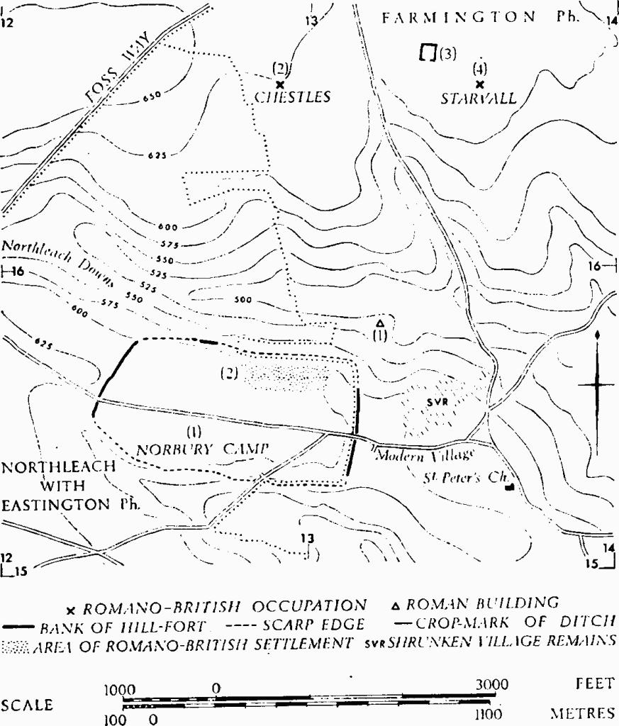
The notable series of linear ditches described under (3) is without close parallel in the area, although a comparable interrupted feature appears in Bagendon (1) and Yanworth (2). The Romano-British settlement (2) within Norbury Camp may represent the 'Farmington Villa' mentioned by Witts. (fn. 1) The Foss Way forms the N.W. boundary of the parish; its course on Leygore Hill is noted under (4).
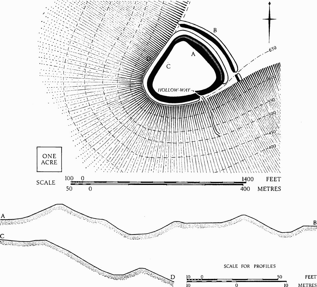
(1) Norbury Camp (SP 127155), univallate hill-fort, unexcavated, encloses 80 acres on a promontory between re-entrant valleys, 1 mile N.E. of Northleach. Plan, p. 89.
The W. and E. sides of the fort are defined by banks set along the extremities of a slight eminence; the N. and S. sides are defined by the edges of the promontory, accentuated in part at least by scarping. On the N., a low bank set on a terrace beneath the scarp edge and extending for about 220 ft. along the inner side of a track may be the northern 'mound' mentioned by Witts. The ploughed W. bank, 50 ft. wide, rises 1½ ft. above the interior and contains limestone blocks up to 3 ft. long; the ditch shows only as a crop-mark. The E. bank, about 16 ft. wide and 2 ft. high, ends 200 ft. S. of the steeply scarped N.E. corner; no ditch is visible. Original entrances, used by modern roads, may be represented by a gap near the centre of the E. bank and by a hollow-way in the S. scarp.
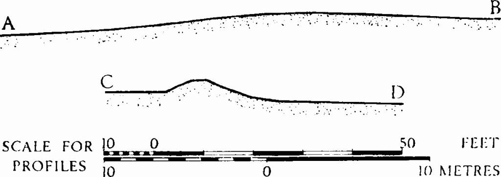
Norbury Camp. Profiles
(plan, p. 89).
N.M.R., OAP SP 1215/1/370–1.
Camden, Britannia (ed. Gough, 1789), I, 279. Playne (1876), 210, No. 17. Witts (1883), 37, No. 72. Bagendon, 25, n. 4.
Monuments in Farmington and Northleach with Eastington.
(2) Romano-British Settlement (SP 129156), within Norbury Camp (1), ploughed out, covers at least 6 acres along the 600-ft. contour in the N.E. quarter of the hill-fort. It is 400 yds. S.W. of Clearcupboard Villa (Farmington (1)), and 100 ft. higher.
Pottery of 1st-4th-century date, roof and flue tiles, dressed stones and wall foundations are reported. The finds, including part of a stone trough, are in a private collection.
TBGAS, 87 (1968), 205, No. 17. Also oral information from Mr. P. E. Gascoigne.
(3) Linear Ditches and Enclosures (SP 10061261– SP 11971345), undated, show as crop-marks on the plain, 1 mile S. of Northleach. The earthworks extend for 1¼ miles E. and N.E. from the Salt Way over generally level ground, but crossing one dry valley. It is possible that the lines which cross the 600-ft. contour about SP 116129 relate to natural jointing or fissuring (an opinion kindly given by Dr. G. A. Kellaway of the Institute of Geological Sciences). Plan, p. 90.
N.M.R., OAP SP 1112/1/358–72.
(4) Roman Road (SP 118159). The agger of the Foss Way on top of Leygore Hill was excavated by Mrs. H. E. O'Neil and proved to be 20 ft. wide between the ditches. A terrace-way E. of the modern road (117161) represents the original course of the Roman road down the hill slope to the north.
PCNFC, XXXIV (1964), 133–7.