An Inventory of the Historical Monuments in the County of Cambridgeshire, Volume 1, West Cambridgshire. Originally published by Her Majesty's Stationery Office, London, 1968.
This free content was digitised by double rekeying. All rights reserved.
'Lolworth', in An Inventory of the Historical Monuments in the County of Cambridgeshire, Volume 1, West Cambridgshire(London, 1968), British History Online https://www.british-history.ac.uk/rchme/cambs/vol1/pp170-172 [accessed 30 April 2025].
'Lolworth', in An Inventory of the Historical Monuments in the County of Cambridgeshire, Volume 1, West Cambridgshire(London, 1968), British History Online, accessed April 30, 2025, https://www.british-history.ac.uk/rchme/cambs/vol1/pp170-172.
"Lolworth". An Inventory of the Historical Monuments in the County of Cambridgeshire, Volume 1, West Cambridgshire. (London, 1968), British History Online. Web. 30 April 2025. https://www.british-history.ac.uk/rchme/cambs/vol1/pp170-172.
In this section
29 LOLWORTH
(O.S. 6 ins. aTL 36 N.E., bTL 36 S.E.)
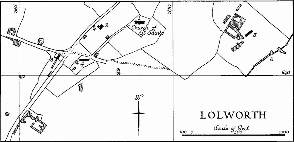
Lolworth is a village and parish 6 m. N.W. of Cambridge. The bounds form an approximate square, the N.E. side being the Huntingdon road; the boundary to the N.W. with Boxworth is indented, but the S.W. and S.E. boundaries are comparatively straight, the S.E. boundary being continuous with that of Childerley. The area is 1110 acres, with drainage to the N.E. from boulder-clay land between the 100-ft. and 200-ft. contours through gault and greensand to Kimmeridge and Ampthill clays. Along the road the height above O.D. drops in places below 50 ft.
The present village, a scattered and rather unrevealing remnant, lies on the edge of the boulder clay to the S. of the church. There are indications here of a triangular or wedge-shaped green, the tip of which was around N.G. TL 36556390. The enclosure map of 1845 (C.R.O.) shows this far end still surviving with a close immediately to the N. inscribed 'The Green'.
It seems possible that the original nucleus lay between the church and The Grange, where Lolworth Spring would have afforded a water supply. Here Long Lane was no doubt the old feeder to the high road, but as at Boxworth a quicker access to the N.W. is now used. The former road to Childerley from the S. extremity of the green is no longer made up.
The few houses in the village are nearly all mid 19th-century or later.
Ecclesiastical
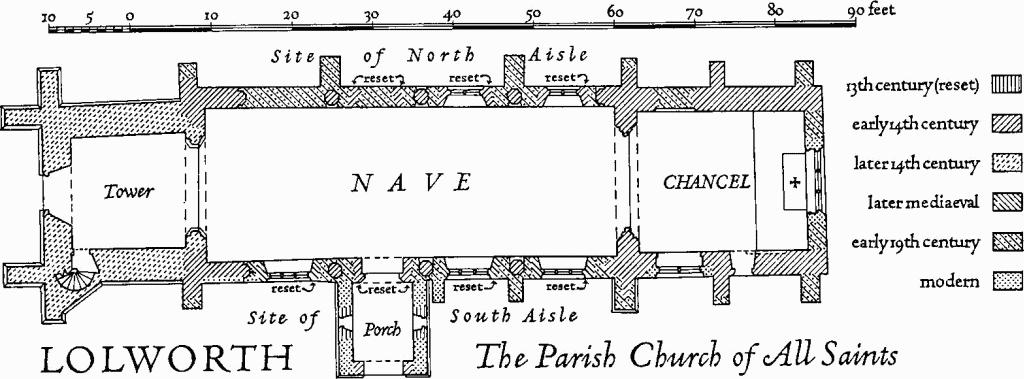
b(1) Parish Church of All Saints (Plate 11), at the N.E. end of the village on ground sloping down to the Huntingdon road, consists of a Chancel, Nave, now unaisled, with rebuilt S. porch, and West Tower. The tower is faced with limestone rubble, the remainder with field stones, brick and reused ashlar; dressings are of freestone and clunch; the roofs are slated.
Lolworth
Reused material includes some blocks with diagonal tooling and one clunch voussoir, W. of the S. door, worked with dog-tooth; two trefoiled windows reset in the S. porch are 13th-century. The fabric otherwise is generally 14th-century, the tower being later than the rest. The church is smaller now than it was. By 1852 the chancel had been shortened and reduced in height, the aisles demolished and the arcades blocked and buttressed. The church was restored in or about 1890.
Architectural Description—The Chancel (20¾ ft. by 17¼ ft.) has a modern E. window. At the W. end of the N. wall, which is partly refaced with brick, the sill of an early 14th-century window, now blocked, is visible outside; inside, the moulded splays and springers of the rear arch can be seen. In the S. wall are remains of two similar windows, the first, also blocked, with raised sill to allow for a priest's doorway, the second window obliterated, except for the splays and sill, by a modern one. The priest's doorway has continuous moulded jambs and head with a moulded label and has been restored. The 14th-century chancel arch is of three moulded orders, the outer two continuous, the inmost carried on attached semi-octagonal shafts with moulded caps; these are somewhat mutilated and the lower parts of the shafts are plastered up.
The Nave (51 ft. by 18½ ft. E. to 19 ft. W.) has on either side an early 14th-century blocked arcade of four bays with an inward label, the blockings being the full thickness of the walls except for small gaps inside and out which reveal parts of the octagonal piers with their moulded caps and of the two chamfered orders of the arches. Doorways have been reset in the blockings of the third arches, that to the N., blocked in turn, continuously moulded and with an external label, that to the S. of two continuous moulded orders. Under the remaining arches, except for the last on the N., are reset windows: those in the first two bays on the N. are 14th-century, of two lights with reticulated tracery; those on the S., of three graduated cinque-foiled lights in depressed four-centred heads, are later mediaeval; all have labels. The S. porch entrance incorporates a few old dressings, additionally to the reset windows mentioned above.
Lolworth, the Parish Church of All Saints
The West Tower (14 ft. square) has W. angle buttresses which rise in two stages to a string-course dividing the bell chamber from the body of the tower; a stair turret is contrived against the E. side of the S. buttress. The continuously moulded W. doorway and the W. window, of two trefoiled lights with a quatrefoil in a four-centred head, have lost their labels. Above the W. window is a lancet lighting the ringing chamber. The four windows of the bell chamber resemble the W. window. The parapet is plain. The tower arch is continuously moulded to the E. and of two chamfered orders to the W.
Fittings—Bells: three; 1st dated 1703, the remainder 18th-century; all, according to Raven (Church Bells of Cambs., 157), by Richard Keene. Bell frame: with pits for four, one cut away, perhaps contemporary. Benefactors' tables: on N. wall of ringing chamber of tower (1) recording gift of plate to the parish in 1740—see Plate (1) below; (2) recording 19th-century bequests by the Cotton family for the benefit of the poor of Lolworth. Brass: in chancel, consisting of a shield of ten quarters, Cutts impaling Brocket; and a detached inscription plate of Margaret (Brocket) Cutts, 1610. Brass indents: at W. end of nave (1) of rectangular inscription plate; (2) of two small figures and attached inscription plate, late mediaeval. Churchyard cross : Base only, loose in nave, square to octagonal, with angle stops and square socket for shaft, mass dial scraped on upper surface, mediaeval. Coffin lid: in tower, carved with a cross having head of eight arms flory and additional similar enrichment half way up the shaft, 13th- or 14th-century. Decalogue:—see Royal Arms below. Door: at foot of tower stair, of planks strengthened by a criss-cross of iron straps and studded with nails, 16th- or 17th-century. Font : of clunch, bowl panelled with quatrefoils and stem with window forms suggesting a late 14th-century date. Glass: in heads of N. window of nave, early 19th-century. Monument and Floor slabs. Monument :: Fixed to the E. wall externally a sarcophagus in freestone and composition, of Charles Humfrey, 1796, and Elizabeth his wife, 1819. Floor slabs: In chancel (1) of Sir John Cutt, with blank incised shield; (2) of James Bridgman, rector, 1631. In nave, at W. end (3) incised with a cross and a name, perhaps 'Iohannes', at foot; traces of black filling; 15th- or 16th-century; (4) worn and broken, with incised cross flory and marginal black-letter inscription '[hic iacet domin]us Thomas . . . quondam rector [huius ecclesiae] . . . (Cole, Inscriptions and Arms from Cambs., 110); probably 15th-century. Painting: at W. end of N. wall of nave (1) in red ochre, 'Incredulity of St Thomas', 14th-century, painted over since 1950. Some traces of geometrical painting on the N. arcade have also disappeared, although some still remain; on N. wall of chancel (2) wooden panel 'Raising of Lazarus', Flemish, 17th-century. Plate: includes a cup, paten and flagon, all London 1740 and inscribed and dated 1740. Royal Arms: in tower, pedimented panel in three bays with arms of George I and smaller side bays inscribed with Decalogue; in the pediment 'G.R. 1721'. Screen: Five major and a number of minor pieces of woodwork from a chancel screen still in situ in 1852 are preserved in the tower; included are the flowing tracery heads of two open window forms, 14th- or early 15th-century. Seating: incorporates some late mediaeval applied tracery including spandrels with a shield of St. George, and another (unidentified 12), also some 17th-century moulded and enriched panelling. Tiles: in sanctuary, geometrical and foliated pattern in red, yellow, black and blue in the ecclesiological manner c. 1850. Miscellaneous: Stonework lying loose in the nave and tower includes tracery fragments and a piece of cornice enriched with flower trail and ball-flower; mostly 14th-century.
Secular
b(2) Rectory, now secular, two-storeyed, of white brick with hipped slated roofs, much altered, c. 1850.
b(3) School and School house, to a T-shaped plan resembling a hall and cross wing, of white brick with tiled and gabled roofs. The School is a single open room with metal-framed, round-headed windows; the house is two-storeyed and has sash windows with cambered heads. Apparently erected between 1842 and 1845.
b(4) House (Class J), of one storey and attic; framed, plastered and thatched; of 17th-century origin.
b(5) Houses, two-storeyed terrace of four with coach house and loft at S. end; white brick and slate; 1842–1845.
Earthworks
b(6) Moated site (Class A1(b); N.G. TL 373641), to the S.E. of Lolworth Grange, on Kimmeridge clay sloping slightly N. Only the S.E. side remains of a trapezoidal moat, complete in 1842, when it was shown on the tithe map as measuring internally 238 ft. S.E., by 225 ft. N.W. The entrance was in the N.W. side. The remaining ditch, with a stream running along it, has been recut and its dimensions, 40 ft. wide and 8 ft. to 9 ft. deep, are probably greater than before. There are faint traces of the other three sides.
(7) Cultivation remains (not on O.S.). Slight traces of ploughed-out ridge and furrow can be seen on air photographs. The ridges were straight and 6 yds. to 7 yds. wide except E. of College Farm at N.G. TL 369647 where ridges 11 yds. to 13 yds. wide existed and N. of Roger's Wood at 368645 where they were curved. The access or head ways are traceable as curving soil marks 60 ft. to 70 ft. wide; one ran W. and W.S.W. from College Farm. In 1842 most of the parish was divided into three open fields, 'Beacon', 'Little' and 'Mill' Fields, with several access ways leading to the furlongs. The traces on air photographs fit the strip pattern shown on the tithe map exactly; this map also shows that the width of ridges varied with the holder.
(Ref: tithe map 1842 (T.R.C.); enclosure map 1845 (C.R.O.); air photographs: 106G/UK/1490/3343–6; CPE/UK/1952/4011– 13.)
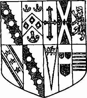
Lolworth Church. Brass
(Ht. 9¾ ins.)