An Inventory of the Historical Monuments in the County of Cambridgeshire, Volume 1, West Cambridgshire. Originally published by Her Majesty's Stationery Office, London, 1968.
This free content was digitised by double rekeying. All rights reserved.
'Papworth St. Agnes', in An Inventory of the Historical Monuments in the County of Cambridgeshire, Volume 1, West Cambridgshire(London, 1968), British History Online https://www.british-history.ac.uk/rchme/cambs/vol1/pp198-203 [accessed 30 April 2025].
'Papworth St. Agnes', in An Inventory of the Historical Monuments in the County of Cambridgeshire, Volume 1, West Cambridgshire(London, 1968), British History Online, accessed April 30, 2025, https://www.british-history.ac.uk/rchme/cambs/vol1/pp198-203.
"Papworth St. Agnes". An Inventory of the Historical Monuments in the County of Cambridgeshire, Volume 1, West Cambridgshire. (London, 1968), British History Online. Web. 30 April 2025. https://www.british-history.ac.uk/rchme/cambs/vol1/pp198-203.
In this section
34 PAPWORTH ST. AGNES
(O.S. 6 ins. aTL 26 N.E., bTL 26 S.E.)
Papworth St. Agnes
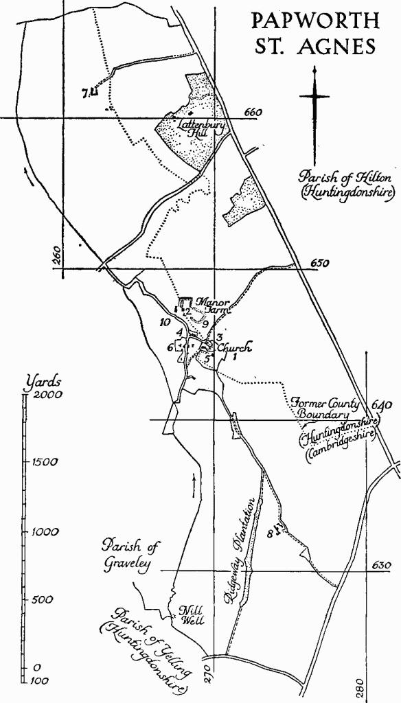
Papworth St. Agnes, formerly known as Papworth Agnes, is said to take its name from one Agnes de Papewurda (Reaney, 'Place-names of Cambs.', 171); it is also distinguished by the epithets 'Magna' and 'Olde'. The present extent of 1298 acres excludes 18 acres lost by modern boundary adjustments with Papworth Everard. Before 1895 some 586 acres in the N.E., including a part of the manor house (Monument (2)), were in Huntingdonshire. The S. end of the parish, which is long and narrow, lies fairly high and here Nil Well, a chalybeate spring, evidently shared with the neighbouring settlements of Yelling and Graveley, feeds a small brook draining N. which forms much of the W. boundary. On the E. Ermine Street separates Papworth St. Agnes from Hemingford Abbots and Hilton. The more low lying parts are Oxford clay with a patch of glacial gravel to the W. of the village on the E. side of the brook; the higher ground is boulder clay. The fact that a small estate here was held in the 13th century under the Bishop of Ely at a rent of 25 wooden trenchers (Lysons, Cambridgeshire, 246) suggests that the terrain had been sufficiently wellwooded to support an appropriate rural industry.
The village, now decayed, consists almost entirely of 19th-century estate-built cottages, interspersed with vacant and derelict closes, along a N. and S. trackway. This last seems to have been one of several intersecting in the area immediately to the W. of the church. Emparking associated with the manor house, and more recently with the rectory (Monument (5)), may to some extent have obliterated an earlier lay-out.
Ecclesiastical
b(1) Parish Church of St. John Baptist, which was being rebuilt in 1530 (will of Anthony Mallory; PCC 32 Byngeley) is now almost entirely modern; the tower (Plate 24) is stated to have been rebuilt again in 1848 (Ecc. Top. Cambs. (1852), No. 42), and the remainder in 1854. The walls are now faced with a chequer of reused ashlar and field stones.
The only certainly ancient part of the fabric is the early 16th-century W. door, which has moulded jambs, continuous depressed four-centred inner and square outer head with a moulded label and spandrels with blank shields. The tower and chancel arches may be copies, with additional embellishment, of corresponding old features.
Fittings—Bells: two by Thomas Norris, 1637, the second bearing the name 'Thomas Catar'; Bell frame: old, for three, reset. Font: in churchyard on S. side: shallow octagonal bowl on shaped and moulded quatrefoil stem; 13th-century. Monuments and Floor slab. Monuments: in tower—on N. wall (1) of Henry Sperling, rector, 1821, signed 'J. BACON FT LONDON'; (2) of Eliza Sperling, 1836; of HenriettaFrances Sperling, 1836; of Julia Sperling, 1822; of Mary Sperling, 1827; children of Henry Piper Sperling, signed 'WILLS NEW ROAD LONDON'; (3) of Elizabeth Vaughan, 1750—on S. wall (4) of Thomas and Elizabeth Rutherforth, 1747, pedimented tablet with flanking pilasters and apron having cartouche of arms. In the churchyard, a few 18th-century headstones N. of the nave. Floor slab: of William Hayes, 1673, and Daniel Hayes, his brother, 1704, both rectors. Plate: includes a paten, London 1669 and two identical cups, London 1772.
Secular
b(2) Manor Farm, house and buildings, is situated at the N. end of the village. Various earthworks (Monuments (9), (10) and (11)), adjoin but the relation of these to the standing remains is not clear, partly because of the disrupting effect of the road leading N. out of the village.
The House (Plate 122), that of the manor of Russels, of two storeys partly with attic, has hipped and gabled roofs covered with tiles. The plan is now approximately square except for modern additions to the N. The E. half, mostly of reused stone, is part of a small mansion of elaborated Class-H design, which was perhaps never completed. This E. half is said to have been built in 1585 (W. M. Palmer evidently thought so, Cambs. and Hunts. A. S. Trans. LX (1930), 416; his source has not been identified) for William Mallory, who died in the following year. The fine plaster ceilings in this part of the house were made either for him or for his son of the same name (d. 1614–5). Sir Henry Mallory, the first William's grandson, sold the property to the Caters at an unknown date before 1637 (C.U.L. Add. MS. 3905 (9); see inscription on 2nd bell in Church above). In the mid 17th century a block was added on the W. side of the hall, its S. elevation being carried across the end of the old work. There was further remodelling c. 1700 when the W. end of the 17th-century block was prolonged some 2 ft. and the house squared off to give a uniform W. front. There has been some modern restoration.
The E. front, all in stone and of the 16th century, consists of the projecting gable end of the N. cross wing and adjoining E. wall of the main range. This last has a window on either floor, each divided into five lights with hollow-moulded mullions and a transom. The oriel of the cross wing, with similar fenestration, is a modern replacement. Above a string-course at eaves level the gable has a parapet with plain kneelers and an original window of three lights. The N. side of the cross wing, like the W. front in stone, has two windows, each of five tall elliptical-headed lights; the upper one is 16th-century, the lower a modern restoration. Just short of the E. end of the wall is an original three-stage buttress.
The 17th-century S. elevation, rendered over brick, has five windows in stone, symmetrically disposed except for the short length of wall added when the W. front was built; in place of the middle window on the ground floor is a patch of modern brickwork. The windows are divided into two lights with ovolo-moulded mullions and transoms and have moulded architraves; the two lower windows have moulded cornices. At the E. end is a 16th-century doorway with chamfered jambs, four-centred inner and square outer head, leading into the demolished or uncompleted screens or service wing of the original house. A chimney on the W. side of the hall issues at the ridge in a stack of two shaped flues with conjoined capping.
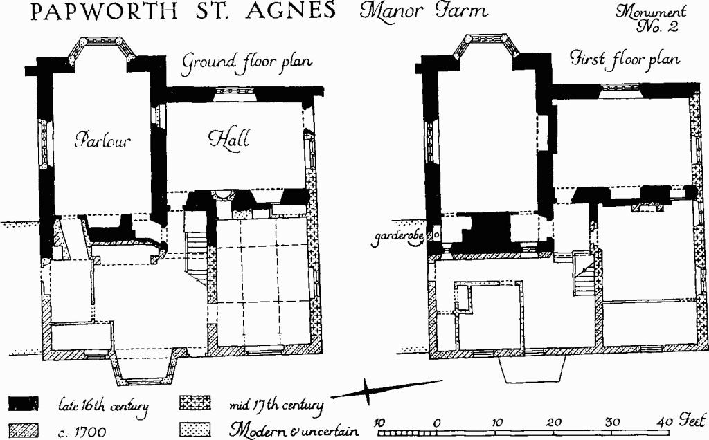
Papworth St. Agnes, Manor Farm
The W. front, of red brick, much of it reused and irregularly bonded, is of c. 1700, with moulded platband at first-floor level and moulded wooden cornice at the eaves. These are on a slightly lower level than on the S. side, due to the enlargement of the house when the W. front was built. Doors and windows are later than the front, but some of the windows are set in the old flat-arched openings.
The modern entrance hall incorporates a ground-floor room in the N.W. corner of the house, and, on the S.E. an original 16th-century square stair turret occupying the angle between the main range and the cross wing. The lower part of the W. wall of the turret and the stair itself have been removed, but the upper brick-built walls and gabled roof rising above the leads survive intact. There are original stone doorways out of the turret on either floor to the N. and E., those to the E. being in both cases at a slightly higher level, indicating that the stair ascended clockwise in a continuous flight; all four have stop-chamfered jambs with four-centred inner and square outer heads; a fifth, similar doorway on the first floor into the S.W. bedroom is a later intrusion. At the top of the turret, an original door in the E. gable communicates with the roof over the old main range; in the W. gable is an original window. The fireplace in the entrance hall is set under a stop-chamfered bressummer carried on 18th-century brick piers; the W. end wall of the cross wing has been thickened to accommodate the additional flue. The parlour, entered through a small lobby, has a moulded clunch fireplace surround at the W. end with four-centred inner and square outer head. In the S. wall is a mutilated and blocked doorway into the hall. The E. end of the room has remains of a 16th- or early 17th-century plaster ceiling of intersecting rectilinear ribs with pendants; lengths of frieze and cornice (Plate 124) also survive, the former enriched with palmettes and scroll-work. Both the ceiling and frieze retain traces of colour and, probably, some gilt.
The hall has a chamfered clunch fireplace surround with four-centred inner and square outer head, but the outer order has been cut back. The insides of the three doorways have wooden lintels, that out of the former turret being moulded. Some old panelling and cupboarding is adventitious. The 16th- or early 17th-century plaster ceiling, almost complete, has a pattern of curved and rectilinear ribs with paterae at intersections and trefoils at other angles; at intervals are cartouches of arms of Mallory, reversed by the plasterer. Below the moulded cornice is a frieze with a trail of clover ornament suggesting the letters 'WM'. W. of the hall is a room occupying the ground floor of the added 17th-century block. It has a ceiling divided into nine panels by intersecting primary cross and secondary longitudinal beams, all moulded; the middle panel is the largest; the others are somewhat irregular in shape and smaller, suggesting that the ceiling has been reset. On the W. the ceiling has been made out c. 1700 with short unmoulded lengths. The surround to the fireplace has been removed.
The bedroom over the parlour is entered through a lobby at the side of the parlour chimney. This last is screened off from the bedroom by a partition with wooden doorways at either end having moulded jambs and, originally, four-centred heads; the doorway at the S. end is for the lobby, that at the N. end opens into a garderobe (Plate 123), having a segmental-headed alcove in the N. wall in which is the original seat in the form of a heavy perforated wooden plank. On the N. face of the wall, originally outside but now giving on to a modern stair into the roof space, is a blocked segmental-headed opening in brick just below the level of the seat. The lobby and the garderobe were lit by windows in the gable end, respectively of two lights and one light, but these now face on to a landing. The bedroom has a fireplace in the S. wall with moulded surround having a four-centred inner and square outer head. At the wall head is a plaster frieze of palmettes and sprays with moulded cornice rising to an elaborate plaster ceiling (Plate 125) of the 16th or early 17th century. This is divided into square fields by a cruciform arrangement of volutes framing pendants and linked by cruciform twenty-sided panels; in the centre of each field is an achievement of arms, two unidentified coats (unidentified 14 and 15) quartering Mallory, flanked by the initials 'MW', the whole composition having been reversed by the plasterer.
The bedroom over the hall has a moulded clunch fireplace surround with four-centred inner and square outer head. S. of this a small doorway with stop-chamfered jambs, four-centred inner and square outer head, leads into a recess which may have been a garderobe. The ceiling (Plate 124) is similar in character to that of the hall, but simpler, and has, repeated at intervals, an achievement of quartered arms of Mallory reversed, as in the previous room. The frieze (Plate 124), which is incomplete, is a comparatively free arabesque.
A third bedroom, W. of the foregoing, has a wooden fireplace surround with elaborate bolection moulding.
The roofs over the 16th-century main range and cross wing are of queen-post construction, without collars, and with substantial wind braces to the side purlins. At the N.W. corner of the hall roof is the original entrance, already described, from the head of the former turret stair. The attic over the cross wing is boarded and lit from the E. by the three-light window described with that front. This end of the attic is enclosed by a studwork partition and ceiled; the enclosure is of uncertain age, but queen posts flanking the window are painted with tabernacle work in red, apparently of the 16th century, suggesting an oratory (Plate 123).
Loose stonework in the garden to the E. of the house includes a number of limestone fragments, 12th-century to late mediaeval, many worked to a clean face for re-use and resembling the walling of the house.
The Buildings comprise, W. of the house, a rectangular redbrick store or granary, probably of 17th-century origin, now ruinous. S. of the foregoing is a comparatively large red-brick barn with slits in the side walls and projecting porch to the E., also in ruins; the barn, which is 17th- or 18th-century, appears to have connected at the S. end, which is open, with a now vanished timber structure; the porch and the S. end are strengthened by angle buttresses.
S.E. of the house about 30 yds. and close to or on the fill of the moat is a pigeon house of c. 1700 with walls of red brick, diagonal dentilation at the eaves and pyramidal tiled roof having horizontal apertures in the N. and S. slopes; the inside has been gutted. W. of the pigeon house along the inside of the moat is some 60 ft. of walling in red brick, part with chamfered plinth, all diapered in black, standing to a height of about 5 ft., and 2 ft. 4 ins. thick. This may be the remains of stables or other offices, but could be a pretentious boundary wall. Garden walls to the E. of the house, less impressive, appear to be 18th-century.
b(3) School and School House, now a dwelling, combined in a single rectangular structure which originally included an outshut the length of the E. side. The walls are of rendered brick, the roof is tiled; the S. end towards the church is Tudoresque; c. 1840.
b(4) Bakehouse, communal, but now disused, standing on a small green in the village, of white brick with slated roof, c. 1850. The E. end is pedimented; the W. end has a tall industrial chimney. The interior of the building, which is said to have also been used for scalding pigs, has been altered.
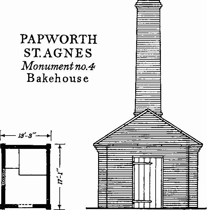
Papworth St. Agnes, Monument No. 4, Bakehouse
b(5) Rectory now alienated, two-storeyed and of white brick, erected for the Rev. H.J. Sperling in 1847–8 by a builder called John Bland at a price of £497, exclusive of timber which was to be supplied from the estate (MS. in house). The idiom is a free adaptation of Georgian with sash windows irregularly placed and hipped slated roofs of varying dimensions. The plan allows for two comparatively large ground-floor rooms on the S. or garden front separated by a smaller one. N. of this smaller room is the stair hall (Plate 109) flanked by offices and on the W. by the entrance hall.
Interior detail includes marble fireplace surrounds in rococo revival and a number of original cast-iron grates, some of Gothic design.
b(6) Passhouse Farm, L-shaped, partly two-storeyed and partly one-storeyed with attics, framed and plastered, with thatched roofs, gabled hipped and half-hipped, is of 17th-century origin. A number of structural timbers are exposed inside, including chamfered and stop-chamfered beams. The house conforms to no plan type and appears to have been much altered.
a(7) Dumptilow Farm consists of a two-storeyed Class-U house with attached farm building forming a single range; mid 19th-century. The combined front is to the E., in white brick broken by pilasters at irregular intervals; the roofs are slated.
b(8) Hill Farm consists of a house and buildings. The House (Class U) two-storeyed with attics and cellars, of white brick with two tiled roofs in parallel, is c. 1800. The Buildings, mostly to the W. of the house and of the early to mid 19th century include a low N. and S. range grouped around a two-storey centre block in brick with a pair of bull's eyes in the upper stage.
Earthworks
b(9) Moated Site (Class A3; N.G. TL 268647), at Manor Farm (Monument (2)), consisting of a moat, a secondary enclosure, and a hollow-way with building platform is that of the manor of Russels which was in the Mallory family from the 14th to the 17th centuries. The moat is probably defensive; the enclosure may have been added in the 17th century and represents gardens. The site is bounded by pasture fields except on the S.W. where the road separates it from Monument (10) with which it should perhaps be considered as a single complex. This road cuts ridge and furrow to the W. and may be relatively new. The moat once surrounded the house; the N. half, which is comparatively complete, has a wet ditch 35 ft. to 40 ft. wide, 3 ft. to 6 ft. deep, 15 ft. to 20 ft. wide at the water level and with 1 ft. to 2 ft. of water. It is trapezoidal and measures 240 ft. N., by 350 ft. E., by 180 ft. S., by 330 ft. W. The N. side, undisturbed except for extensions of the N. angles to form drinking places for cattle, has an outer bank 25 ft. wide and 4 ft. high. The S. half of the moat has been wholly or partly filled, perhaps as late as the 19th century; 17th- to 19th-century farm buildings, now ruinous, have encroached on the S.W. angle. Inside, 40 ft. to the E. of and parallel to the W. side is a pond 140 ft. long, 40 ft. wide, 4 ft. deep and holding 2 ft. to 3 ft. of water. Within the N. angles are circular mounds 30 ft. to 40 ft. across and 1½ ft. to 2 ft. high.
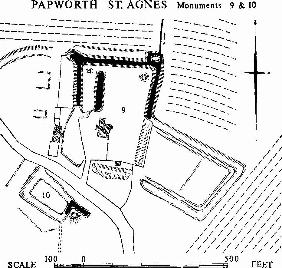
Papworth St. Agnes, Monuments 9 & 10
The enclosure, orientated W.N.W. to E.S.E., is attached to the S. end of the E. side of the moat; it is 320 ft. N., by 180 ft. E., by 260 ft. S., by 180 ft. W., with a ditch 30 ft. wide, 2 ft. to 3 ft. deep and 10 ft. to 11 ft. across the bottom. This ditch is boggy and may originally have been wet. There is an internal bank 12 ft. wide and 2 ft. to 2½ ft. high.
A curving hollow-way diverging to the N.E. from the road encloses with it a roughly triangular area to the W. of the moat; it is 36 ft. wide, 3 ft. deep, and 12 ft. wide across the bottom. Within the triangle are the ruined farm buildings alluded to above and, to the E., two platforms 1½ ft. high; that on the N. measuring 50 ft. N. to S., that on the S. 40 ft. E. to W. by 15 ft.
b(10) Moated Site (Class A1(a), N.G. TL 267646, not on O.S.), on flat glacial gravel S.W. of and adjoining the road which separates it from the foregoing site, of which it may be a part.
The moat encloses a trapezoidal area 63 ft. N.W. by 121 ft. N.E., by 36 ft. S.E., by 130 ft. S.W. and has a wet ditch 20 ft. to 37 ft. wide and 3½ ft. deep. The E. angle has been disturbed by the cutting of a rectangular pond, continuing the line of the N.E. side. Spoil from the pond has been heaped up on its S. side to form an irregular mound 50 ft. across and 5 ft. high, which has partly slipped into the S.E. side of the moat and narrowed its width.
b(11) Garden Remains (centre at N.G. TL 267645; ponds only on O.S.), in an elongated pasture field to the S.W. and W. of the village street. This field occupies an island of glacial gravel overlying the surrounding Oxford clay. It contains many earthworks but all except the moat (Monument (10)) seem to be later than the ridge and furrow running E. to W. There are five rectangular ponds and one L-shaped pond, three circular mounds 35 ft. to 50 ft. across and 2½ ft. to 4½ ft. high and several shallow irregular hollows. Trees, obviously intentionally planted, line the hedges and occur in clumps within the field. These suggest that the area was laid out as an extended garden or small park for the manor house (Monument (2)) after the ridge and furrow and the moat had been abandoned. The mounds and rectangular ponds probably belong to this operation, which perhaps took place in the 18th or 19th century. The hollows may be due to later gravel digging.
(12) Cultivation Remains (not on O.S.). Much ridge and furrow survives in the parish, being remains both of openfield furlongs and of old closes. The former have ridges 60 yds. to 570 yds. long, 6 yds. to 11 yds. wide and 9 ins. to 1 ft. high. Examples can be seen E. of Dumptilow Farm around N.G. TL 262661, 16 curving ridges; and around N.G. TL 262659, 19 curving ridges; S. of Lattenbury Hill around N.G. TL 269659, 45 straight ridges and N. of Manor Farm around N.G. TL 268649—three E. to W. furlongs with 20 to 24 straight ridges in each, and two N.E. to S.W. furlongs respectively with 4 and 15 curved ridges. To the N.E. of Manor Farm around N.G. TL 270648 is a block 80 yds. wide of 21 ridges running S.W. to N.E., 570 yds. long. These unusually long ridges are 9 ins. to 1 ft. high but vary greatly in width; at the S.W. end they are 5 yds. to 7 yds. wide for 130 yds., but after a slight curve widen to 7 yds. to 9 yds.; after another 130 yds. and a second curve some widen to 11 yds. to 12 yds. until, after a further 70 yds. to 130 yds. they narrow to 7 yds. to 9 yds.; there is a headland at the S.W. end 10 yds. wide. The length of this block and the changes in direction and width suggest that four furlongs each about 130 yds. long have later been ploughed as one.
S.W. of Manor Farm around N.G. TL 266646 the present road into the village seems to have cut five former closes with ridge and furrow running W.N.W. to E.S.E. which had been combined into one field. From N. to S. they contained respectively 11, 12 and 8 curving ridges, 20 straight ridges and 11 curving ridges. These were 70 yds. to 230 yds. long, 7 yds. wide and 9 ins. high with headlands 8 yds. wide at either end.
Traces of curving open-field ridge and furrow can be seen on air photographs elsewhere in the parish, but nowhere is a complete set of furlongs visible. The precise date of enclosure before 1839 is unknown, but the fact that the parish had for long been in a single ownership would have facilitated its enclosure. The former division of Papworth St. Agnes between Cambridgeshire and Huntingdonshire, lasting until 1895, does not seem to have affected the pattern of the cultivation remains.
(Ref: tithe map 1839; air photographs: 106G/UK/1490/ 3356–8, 3376–9, 4345–7, 4368–70; CPE/UK/1952/1280–5.)